Garfield County Emergency Communications Authority
9.27.25, 12:40 am – I-70 is open at mile marker 130 westbound, Dotsero.
Colorado Department of Transportation
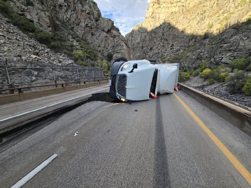
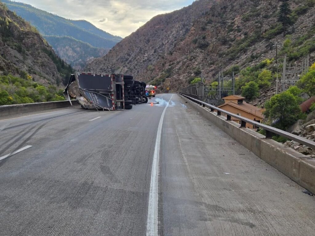
9.26.25, 9:03 pm – Westbound I-70 is closed to through traffic at Wolcott, Exit 157, due to a rolled over CMV crash that took place in Glenwood Canyon at around 6 p.m. this evening. CDOT and its partners worked tirelessly to avoid putting a detour in place — estimated to add four hours of travel time — but unfortunately, I-70 through Glenwood Canyon is an extremely challenging section of road with limited space for operations. There is no estimated time of re-opening.
The detour that is in place directs commuters onto US 6 via exit 157, Wolcott, north on HWY 131 toward Steamboat, west on US 40 towards Craig, south on HWY 13, and back on I-70 near Rifle.
Check COtrip.org or the #COtrip Planner app for more information and road updates.
Bureau of Land Management Colorado, Upper Colorado River District, Grand Junction Field Office
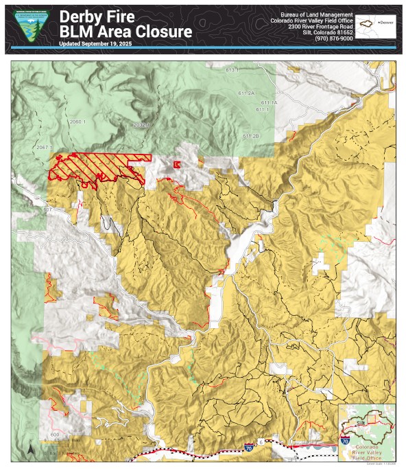
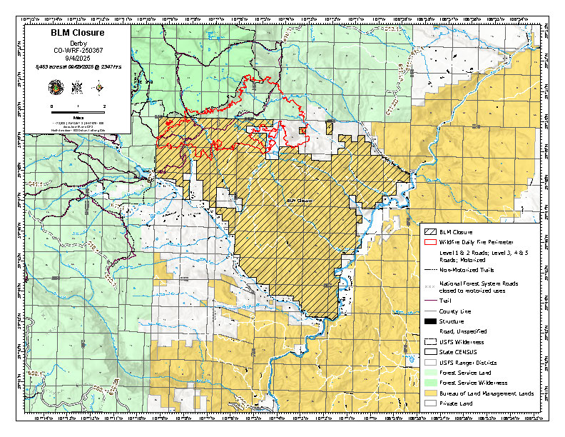
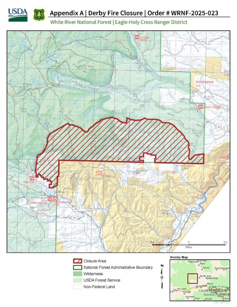
The Bureau of Land Management has reopened more public lands in Garfield and Eagle counties that were previously closed due to the Derby Fire. The updated closure order takes effect immediately.
Some areas inside the burned perimeter remain closed because they’re not safe. There are hazards like burned trees and ongoing work to repair damage from fighting the fire. See below and attached map for details. The closure order and map are also available on the BLM website.
This closure affects: BLM lands north and west of the town of Gypsum, Colorado, that are north of Sweetwater Road; west of the Colorado River; east of the White River National Forest boundary; and south of Derby Creek.
BLM issued the emergency closure Aug. 20 to ensure public and firefighter safety during fire suppression efforts and to reduce exposure to hazardous situations because of fire behavior of the Derby Fire.
This order will remain in effect until fire BLM rescinds the order. The public is to remain clear of the areas still closed. Please use caution and watch for firefighters when traveling in the area. Violations of this emergency order may lead to prosecution, with fines and possible imprisonment.
Thank you for your understanding as we focus on public safety and protecting natural resources.
Type 3 Incident Management Team Patrick Kieran, Incident Commander
The Derby fire is now 70% contained, but despite the fire activity lessening, it is still important to remember that this is an active fire. There is still a significant amount of firefighter traffic and work occurring, and the closures remain in place for the safety of both firefighters and the public.
Information: Eagle-Holy Cross Ranger District (970) 827-5715 (8 a.m. – 4 p.m.) Colorado River Valley Office (970) 876-9000 (8 a.m. – 4:30 p.m.)
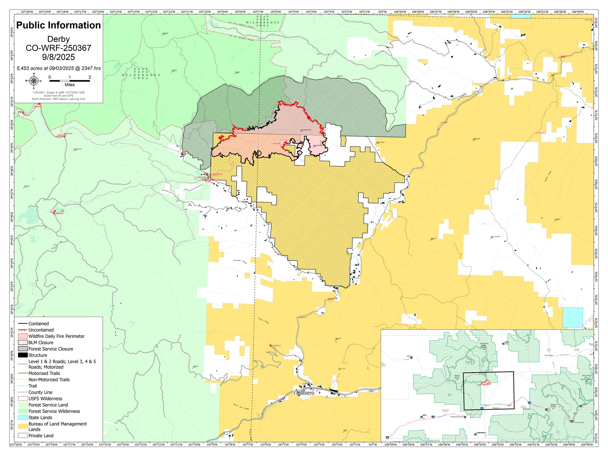
Start Date: 08/16/25 Location: 13 miles north of Dotsero, Colo. Cause: Lightning Size: 5,453 acres Containment: 65% Personnel: 206
Current Situation
The containment of the Derby fire has increased to 65 percent. Fire managers are not expecting further fire growth, and this is the last daily update unless the situation changes. Information will continue to be posted to the Derby Fire Colorado Facebook page, https://www.facebook.com/DerbyFire/, and Inciweb, https://inciweb.wildfire.gov/incident…/cowrf-derby-fire
The type 3 incident management organization will continue strengthening control lines as well as ongoing suppression repair work over the next several days. Fire managers will continue to downsize and remove equipment as needed.
We thank the local communities for their support during this firefighting effort.
Weather and Fire Behavior – Rain showers may occur, bringing along isolated thunderstorms. In the afternoon, gusty and erratic winds can be expected near isolated thunderstorms with potential for gusty outflow winds.
Evacuations and Closures
Fire restrictions and closures remain in place for Bureau of Land Management areas, https://www.blm.gov/ucr-fire-restrictions, and the White River National Forest, https://www.fs.usda.gov/r02/whiteriver/alerts/ . BLM Colorado River Valley Field Office, White River National Forest, and Garfield and Eagle counties are under stage 1 fire restrictions.
A Temporary Flight Restriction (TFR) is in place over the Derby Fire. All unauthorized aircraft (including drones) are prohibited from flying near the fire, as they can interfere with authorized air support operations. For more information, visit https://tfr.faa.gov.
———————————————————————-
Actualización final para el Incendio Derby 8 de septiembre de 2025
Equipo de gestión de incidentes tipo 3 Patrick Kieran, Comandante de Incidentes
Información: Distrito de Guardabosques de Eagle-Holy Cross (970) 827-5715 (8 a.m. – 4 p.m.) Oficina del Valle del Río Colorado (970) 876-9000 (8 a.m. – 4:30 p.m.)
Fecha de inicio: 16/08/25 Ubicación: 13 millas al norte de Dotsero, Colorado. Causa: Relámpago Tamaño: 5,453 acres Contención: 65% Personal: 206
Situación actual:
la contención del incendio de Derby ha aumentado al 65 por ciento. Los administradores de incendios no esperan un mayor crecimiento del fuego, y esta es la última actualización diaria a menos que la situación cambie. La información continuará publicándose en la página de Facebook de Derby Fire Colorado, https://www.facebook.com/DerbyFire/ y Inciweb, https://inciweb.wildfire.gov/incident…/cowrf-derby-fire
La organización de gestión de incidentes tipo 3 continuará fortaleciendo las líneas de control, así como el trabajo de reparación de supresión en curso durante los próximos días. Los administradores de incendios continuarán reduciendo el tamaño y retirando el equipo según sea necesario.
Agradecemos a las comunidades locales por su apoyo durante este esfuerzo de extinción de incendios.
Clima y comportamiento del fuego: pueden ocurrir lluvias, trayendo consigo tormentas eléctricas aisladas. Por la tarde, se pueden esperar vientos racheados y erráticos cerca de tormentas eléctricas aisladas con potencial de vientos racheados.
Evacuaciones y cierres:
las restricciones y cierres de incendios permanecen vigentes para las áreas de la Oficina de Administración de Tierras, https://www.blm.gov/ucr-fire-restrictions y el https://www.fs.usda.gov/r02/whiteriver/alerts/ del Bosque Nacional White River. La Oficina de Campo de BLM Colorado River Valley, el Bosque Nacional White River y los condados de Garfield y Eagle están bajo restricciones de incendios de etapa 1.
Existe una restricción temporal de vuelo (TFR) sobre el incendio de Derby. Todas las aeronaves no autorizadas (incluidos los drones) tienen prohibido volar cerca del incendio, ya que pueden interferir con las operaciones de apoyo aéreo autorizadas. Para obtener más información, visite https://tfr.faa.gov.
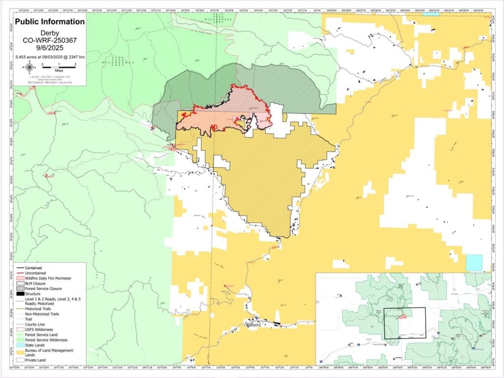
Fire Information: 970-355-3283 (8 a.m. – 5 p.m.) Start Date: 08/16/25 Location: 13 miles north of Dotsero, Colo. Cause: Lightning Size: 5,453 acres Containment: 62% Personnel: 344
Key Messages: A Type 3 Incident Management Team took command of the Derby Fire this morning. Firefighting resources continue to be downsized as containment increases. The Bureau of Land Management has reduced the size of its area closure, for more information visit : https://www.blm.gov/ucr-fire-restrictions.
Current Situation – The fire has seen minimal growth over the past several days. Firefighters are continuing to strengthen and patrol containment lines as well as back haul equipment. In areas with containment, firefighters are continuing suppression repair to restore areas disturbed by firefighting activities such as firelines, staging areas, and helipads. A heavy helicopter, light helicopter and unmanned aircraft systems (drones) are available to assist firefighters today.
The Incident Command Post at the Eagle Fairgrounds is being significantly downsized today.
Weather and Fire Behavior – Rain showers and thunderstorms are expected today and tomorrow but will likely decrease throughout the week. The showers will bring brief gusty winds, but overall winds are expected to remain light. With the incoming monsoon moisture, fire activity is expected to be low. Evacuations and Closures: Fire restrictions and closures remain in place for Bureau of Land Management areas, https://www.blm.gov/ucr-fire-restrictions and the White River National Forest https://www.fs.usda.gov/r02/whiteriver/alerts/. Fire restrictions have dropped to Stage 1.
A Temporary Flight Restriction (TFR) is in place over the Derby Fire. All unauthorized aircraft (including drones) are prohibited from flying near the fire, as they can interfere with authorized air support operations. For more information, visit https://tfr.faa.gov.
Actualización del Incendio Derby 6 de septiembre de 2025
Equipo de gestión de incidentes tipo 3
Patrick Kieran, Comandante de Incidentes
Información sobre incendios: 970-355-3283 (8 a.m. – 5 p.m.) Fecha de inicio: 08/16/25 Ubicación: 13 millas al norte de Dotsero, Colorado Causa: Relámpago Tamaño: 5,453 acres Contención: 62% Personal: 344
Mensajes clave: Un equipo de gestión de incidentes de tipo 3 tomó el mando del incendio de Derby esta mañana. Los recursos de extinción de incendios continúan reduciéndose a medida que aumenta la contención. La Oficina de Administración de Tierras ha reducido el tamaño del cierre de su área, para obtener más información, visite: https://www.blm.gov/ucr-fire-restrictions.
Situación actual: El incendio ha experimentado un crecimiento mínimo en los últimos días. Los bomberos continúan fortaleciendo y patrullando las líneas de contención y el equipo de retorno. En las áreas con contención, los bomberos continúan con la reparación de supresión para restaurar las áreas perturbadas por las actividades de extinción de incendios, como líneas de fuego, áreas de preparación y helipuertos. Un helicóptero pesado, un helicóptero ligero y sistemas de aeronaves no tripuladas (drones) están disponibles para ayudar a los bomberos en la actualidad.
El Puesto de Comando de Incidentes en el recinto ferial de Eagle se está reduciendo significativamente. Clima y comportamiento del fuego: se esperan lluvias y tormentas eléctricas hoy y mañana, pero es probable que disminuyan a lo largo de la semana. Las lluvias traerán breves vientos racheados, pero se espera que los vientos en general sigan siendo ligeros. Con la humedad del monzón entrante, se espera que la actividad del fuego sea baja.
Existe una restricción temporal de vuelo (TFR) sobre el incendio de Derby. Todas las aeronaves no autorizadas (incluidos los drones) tienen prohibido volar cerca del incendio, ya que pueden interferir con las operaciones de apoyo aéreo autorizadas. Para obtener más información, visite https://tfr.faa.gov.