City of Glenwood Springs to Host State of Public Safety Event

Community Q&A with city police and fire departments on Wednesday, June 10

Glenwood Springs State of Public Safety flyer

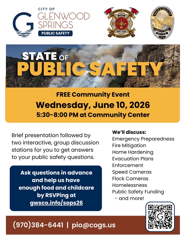
GLENWOOD SPRINGS, Colo. (June 3, 2026) – The City of Glenwood Springs is excited to announce its upcoming State of Public Safety event, taking place Wednesday, June 10, 2026, from 5:30 to 8 p.m. at the Community Center. Doors open at 5:30 p.m. for refreshments and socializing, then event presentations begin at 6 p.m. followed by the question-and-answer sessions.

The event is free and open to all community members, and RSVPs (gwsco.info/sops26) are strongly encouraged to ensure enough food for everyone. Spanish interpretation and childcare will be provided.

The evening sessions will begin at 6 p.m. with brief remarks by Chief of Public Safety Joseph Deras, followed by rotating, interactive Q&A sessions with police and fire department leaders. Residents will take turns asking questions and sharing feedback on topics including:

  • Emergency Preparedness
  • Fire Mitigation
  • Home Hardening
  • Evacuation Plans
  • Enforcement
  • Speed Cameras
  • Flock Cameras
  • Homelessness
  • Public Safety Funding

For anyone who might feel shy about expressing questions or comments in front of a group, there will also be lots of opportunities for written feedback. Questions and comments may also be submitted in advance at gwsco.info/sops26.

###

Contact: Bryana Starbuck, Communications & Engagement Officer, bryana.starbuck@cogs.us


La ciudad de Glenwood Springs celebrará una sesion sobre el estado de la Seguridad Pública

Sesión comunitaria de preguntas y respuestas con los departamentos de policía y bomberos de la ciudad, el miércoles 10 de junio.

Glenwood Springs State of Public Safety flyer in spanish

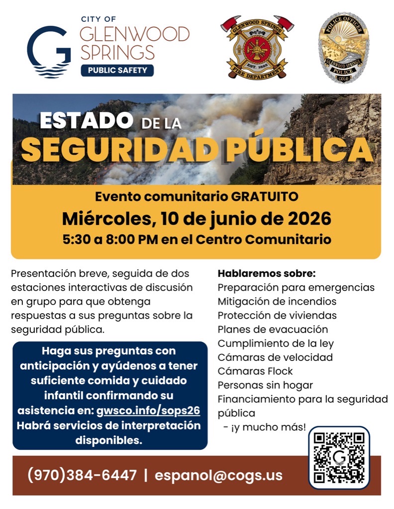
GLENWOOD SPRINGS, Colorado (3 de junio de 2026) – La ciudad de Glenwood Springs se complace en anunciar su evento sobre el estado de la seguridad pública, que tendrá lugar el miércoles 10 de junio de 2026, de 5:30 a 8 p.m., en el Centro Comunitario.

El evento comenzará a las 5:30 p. m. con bocadillos y una oportunidad para convivir. Las presentaciones comenzarán a las 6 p. m., seguidas de una sesión de preguntas y respuestas.

El evento es gratuito y todos los miembros de la comunidad están invitados. Se recomienda confirmar su asistencia para garantizar que haya suficiente comida para todos. Habrá servicio de interpretación en español y cuidado infantil.

Las sesiones de la tarde comenzarán a las 6 p.m. con unas breves palabras del jefe de Seguridad Pública, Joseph Deras, seguidas de sesiones interactivas rotativas de preguntas y respuestas con líderes de los departamentos de policía y bomberos. Los residentes tendrán la oportunidad de hacer preguntas y compartir sus opiniones sobre temas como:

  • Preparación para emergencias
  • Mitigación de incendios
  • Protección de viviendas
  • Planes de evacuación
  • Cumplimiento de la ley
  • Cámaras de velocidad
  • Cámaras Flock
  • Personas sin hogar
  • Financiamiento para la seguridad pública

Para quienes se sientan tímidos al expresar sus preguntas o comentarios frente a un grupo, también habrá muchas oportunidades para enviar comentarios por escrito. Las preguntas y comentarios también podrán enviarse con anticipación en gwsco.info/sops26.

###

Contacto: Bryana Starbuck, Oficial de Comunicación y Participación, bryana.starbuck@cogs.us

City of Glenwood Springs to Host State of Public Safety Event

Stage 1 Fire Restrictions begin June 10, 2026

Above average temperatures and dry conditions with no relief from rain in the forecast

GCSO PRESS RELEASE
June 9, 2026

The Garfield County Sheriff’s Office, Bureau of Land Management (BLM), and the seven fire districts in Garfield County are implementing Stage 1 Fire Restrictions effective at 1 a.m., Wednesday June 10, 2026. This applies to all of Garfield County.

This decision was made with thoughtful consideration. We look at the data, the potential for significant wildfires and balance it with the impacts to our community. Our concern, with the level of fire danger we are seeing; one spark could quickly spread into a dangerous wildfire threatening lives, property and natural resources.

Fire restrictions are implemented based on specific criteria to include moisture content of vegetation, weather outlooks, human risk factors, recent fire behavior witnessed over the past week and firefighting resource availability. It has been hot, dry, and unseasonably windy. So far this year, we have had several Red Flag Warnings. The National Weather Service is forecasting above average temperatures and dry conditions with no relief from rain anytime soon.

With increasingly dry vegetation, severe drought conditions, and more hot and dry conditions approaching, the danger for human caused wildfires increases even more.

What Stage I Fire Restrictions mean in Garfield County

  • Fireworks are not allowed under Stage I Fire Restrictions. Professional fireworks shows may be allowed through the permitting process.
  • All burn permits are postponed/Canceled until further notice.
  • Campfires are only allowed within designated fire grates in Developed Areas (i.e. a permanent in-ground containment structure or store-bought fire pit) A temporary fire pan and rock campfire rings will not be acceptable.
  • No fires of any type including charcoal in undeveloped areas.
  • No smoking except within a designated area, enclosed vehicle or building, a developed area or in an area free of combustibles.
  • No use of fireworks or explosive materials, including “exploding” targets or bullets and tracer rounds.
  • Exercise common sense and industry safety practice when welding or operation of an acetylene or other similar torch with open flame always cleared safe area of vegetation and combustibles.

Penalties
Causing a fire during fire restrictions can be a class 6 felony and can be punishable by fines. Other possible charges range from a Class 2 Felony to a petty offense depending on the value of the damage caused. You may be held financially responsible for damage caused.

Federal lands
The use of fireworks, flares, or other incendiary devices, including exploding targets, are always prohibited on federal lands.

By definition:
A “developed area” is an area, whether within city limits or rural, that is groomed, manicured and or watered, where grasses, brush and trees are regularly attended to by land owner. This includes residential and business areas, improved recreational areas, parks and other common areas.

An “undeveloped area” are lands that are not groomed, manicured, or watered, where grasses, brush and trees have been allowed to grow in a natural environment. This includes green belts that are not landscaped or manicured, open space lands, non-manicured park lands, and other areas where the fire hazard presented by the vegetation is determined by the authority having jurisdiction or designee to be an undue wildland fire hazard.

Stage 1 Fire Restrictions begin June 10, 2026

GSFD: Public Service Announcement

Glenwood Springs Fire Department

Public Service Announcement

April 1, 2026

To All City and Rural-Area Glenwood Springs Residents and Visitors,

We are all aware of the lack of significant snow and rainfall, along with unseasonably elevated temperatures, and recognize the risk of wildfire is at an all-time high this year. Your Glenwood Springs firefighters are prepared and ready to respond quickly to any reports of smoke or fire. We are asking for your help to prevent and reduce the possibility of any sources of ignition.

Please take note of the following:

  1. All Open Burn Permits have been canceled. Glenwood Springs Fire Department (GSFD) will not issue new permits until this winter.
  2. Pay close attention to Red Flag Days in addition to Staged Fire Restriction measures. Follow all local rules and laws- these may vary if you travel and inform any guests visiting you.
  3. Fires are preventable. Take an extra minute to check your trailer chains are not dragging, keep your smoking materials inside, and consider doing yard work early in the morning. Any activity that produces a spark or flame needs to be closely monitored. Save s’mores for winter nights!
  4. Sign up now for Emergency Alerts, city news, and view evacuation plans at www.GlenwoodFire.com
  5. Wildfire moves fast. Ready, Set, Go! Be at the ready for evacuation notices and have a plan for your family and pets. Live Wildfire Ready by preparing your homes and creating defensible space.

Our community continues to build wildfire resiliency through homegrown efforts. We are fortunate to work alongside many agencies and organizations that help us with our mission. There are also new building codes and standards that are being adopted locally and State-wide this month that will ensure long-term success.

For any questions or concerns, please contact our main office at 970-384-6480.

Thank you and be safe,
Robin Pitt
Fire Marshal, Fire Prevention Division

101 W. 8th Street, Glenwood Springs, Colorado 81601
970-384-6480  |  FAX 970-945-8506
SERVICE THROUGH DEDICATION, PROFESSIONALISM AND EXCELLENCE

Glenwood Springs Fire Department
Glenwood Fire website | facebook: #GlenwoodSpringsFireDepartment

GSFD: Public Service Announcement

CRFR: Press Release

Colorado River Fire Rescue

1850 Railroad Avenue | Rifle, Colorado 81650
Telephone, (970) 625-1243 | Fax, (970) 625-2963 | www.crfr.us

Press Release

To all CRFR burn permit users:

Effective 11:59 p.m. 3/26/2026

Due to dry vegetation conditions, many out of control burns, and lack of moisture in the ground. We at CRFR are Requesting all burns to be completed by 1:00 p.m. every day. As always, open burning is not allowed during Red Flag Warnings or wind conditions over 5 mph.

Please help us monitor this situation and maintain safety for all our citizens and their property.

We will continue to monitor the fuels and weather to determine the future of burn permits and open burning.

For additional information, please contact our main office at 970-625-1243.

Thank you.

Prevention Division Chief, Orrin Moon

Colorado River Fire Rescue
CRFR website | facebook: #ColoradoRiverFireRescue

CRFR: Press Release

Garco911: Highway 82 eastbound open

Garfield County Emergency Communications Authority

10.16.25, 9:35 am – Hwy 82 is open, both lanes, at mile-marker 13 EB, 2 miles east of Carbondale.

10.16.25, 9:17 am – Hwy 82 has one lane open at mile-marker 13 EB, 2 miles east of Carbondale, due to an accident.

10.16.25, 8:22 am – Hwy 82 is closed at mile-marker 13 EB, 2 miles east of Carbondale, due to an accident.

Garco911: Highway 82 eastbound open

Derby Fire: Closures remain in place

Type 3 Incident Management Team
Patrick Kieran, Incident Commander

The Derby fire is now 70% contained, but despite the fire activity lessening, it is still important to remember that this is an active fire. There is still a significant amount of firefighter traffic and work occurring, and the closures remain in place for the safety of both firefighters and the public.

For more information on the closures for Bureau of Land Management visit: https://www.blm.gov/ucr-fire-restrictions

For more information on the closures on the White River National Forest visit: https://www.fs.usda.gov/r02/whiteriver/alerts/

map of BLM land closure for Derby Fire
Map of National Forest Service land closure for Derby Fire
Derby Fire: Closures remain in place

Derby Fire: Final Update September 8, 2025

Type 3 Incident Management Team
Patrick Kieran, Incident Commander

Derby Fire final update document
Derby Fire final update document – Spanish
Derby Fire final update Map

Information: Eagle-Holy Cross Ranger District (970) 827-5715 (8 a.m. – 4 p.m.)
Colorado River Valley Office (970) 876-9000 (8 a.m. – 4:30 p.m.)

Start Date: 08/16/25
Location: 13 miles north of Dotsero, Colo.
Cause: Lightning
Size: 5,453 acres
Containment: 65%
Personnel: 206

Current Situation

The containment of the Derby fire has increased to 65 percent. Fire managers are not expecting further fire growth, and this is the last daily update unless the situation changes. Information will continue to be posted to the Derby Fire Colorado Facebook page, https://www.facebook.com/DerbyFire/, and Inciweb, https://inciweb.wildfire.gov/incident…/cowrf-derby-fire

The type 3 incident management organization will continue strengthening control lines as well as ongoing suppression repair work over the next several days. Fire managers will continue to downsize and remove equipment as needed.

We thank the local communities for their support during this firefighting effort.

Weather and Fire Behavior – Rain showers may occur, bringing along isolated thunderstorms. In the afternoon, gusty and erratic winds can be expected near isolated thunderstorms with potential for gusty outflow winds.

Evacuations and Closures

Fire restrictions and closures remain in place for Bureau of Land Management areas, https://www.blm.gov/ucr-fire-restrictions, and the White River National Forest, https://www.fs.usda.gov/r02/whiteriver/alerts/ . BLM Colorado River Valley Field Office, White River National Forest, and Garfield and Eagle counties are under stage 1 fire restrictions.

A Temporary Flight Restriction (TFR) is in place over the Derby Fire. All unauthorized aircraft (including drones) are prohibited from flying near the fire, as they can interfere with authorized air support operations. For more information, visit https://tfr.faa.gov.

derby fire map 9/8/25

———————————————————————-

Actualización final para el Incendio Derby 8 de septiembre de 2025

Equipo de gestión de incidentes tipo 3
Patrick Kieran, Comandante de Incidentes

Información: Distrito de Guardabosques de Eagle-Holy Cross (970) 827-5715 (8 a.m. – 4 p.m.)
Oficina del Valle del Río Colorado (970) 876-9000 (8 a.m. – 4:30 p.m.)

Fecha de inicio: 16/08/25
Ubicación: 13 millas al norte de Dotsero, Colorado.
Causa: Relámpago
Tamaño: 5,453 acres
Contención: 65%
Personal: 206

Situación actual:

la contención del incendio de Derby ha aumentado al 65 por ciento. Los administradores de incendios no esperan un mayor crecimiento del fuego, y esta es la última actualización diaria a menos que la situación cambie. La información continuará publicándose en la página de Facebook de Derby Fire Colorado, https://www.facebook.com/DerbyFire/ y Inciweb, https://inciweb.wildfire.gov/incident…/cowrf-derby-fire

La organización de gestión de incidentes tipo 3 continuará fortaleciendo las líneas de control, así como el trabajo de reparación de supresión en curso durante los próximos días. Los administradores de incendios continuarán reduciendo el tamaño y retirando el equipo según sea necesario.

Agradecemos a las comunidades locales por su apoyo durante este esfuerzo de extinción de incendios.

Clima y comportamiento del fuego: pueden ocurrir lluvias, trayendo consigo tormentas eléctricas aisladas. Por la tarde, se pueden esperar vientos racheados y erráticos cerca de tormentas eléctricas aisladas con potencial de vientos racheados.

Evacuaciones y cierres:

las restricciones y cierres de incendios permanecen vigentes para las áreas de la Oficina de Administración de Tierras, https://www.blm.gov/ucr-fire-restrictions y el https://www.fs.usda.gov/r02/whiteriver/alerts/ del Bosque Nacional White River. La Oficina de Campo de BLM Colorado River Valley, el Bosque Nacional White River y los condados de Garfield y Eagle están bajo restricciones de incendios de etapa 1.

Existe una restricción temporal de vuelo (TFR) sobre el incendio de Derby. Todas las aeronaves no autorizadas (incluidos los drones) tienen prohibido volar cerca del incendio, ya que pueden interferir con las operaciones de apoyo aéreo autorizadas. Para obtener más información, visite https://tfr.faa.gov.

Derby Fire: Final Update September 8, 2025

Derby Fire: Incident management team transition

Rocky Mountain Area Complex Incident Management Team 3

With the reduction in fire activity and resources assigned, the complexity of the Derby Fire is decreasing. In response, a Type Three Incident Management organization will officially take command of the Derby Fire on Saturday at 6:00 a.m. The Incident Commander will be Patrick Kieran. Rocky Mountain Incident Management Team Three would like to thank the citizens of Garfield and Eagle County for your hospitality. Rocky Mountain Incident Management Team Three Incident Commander Ben Sanders talks about our time at the Derby Fire.


Derby Fire official information

FACEBOOK – Derby fire @derbyfire
INCIWEB – Derby Fire
WHITE RIVER NATIONAL FOREST – facebook.com/whiteriverNF @whiteriverNF

__________________________________________
EAGLE COUNTY INFO
DERBY FIRE: EAGLE COUNTY EVACUATION MAP REGISTER FOR ALERTS – 911 alerts
INCIDENT UPDATES – EC Emergency or Reachwell app
FACEBOOK – facebook.com/eaglecountyso @eaglecountyso

___________________________________________

GARFIELD COUNTY INFO
DERBY FIRE: GARFIELD COUNTY INTERACTIVE EVACUATION MAP REGISTER FOR ALERTS – 911 alerts or Reachwell app
INCIDENT UPDATES / SUBSCRIBE – Garfield County emergency
FACEBOOK – facebook.com/garcosheriff @garcosheriff

Derby Fire: Incident management team transition

Derby Fire: BLM reduces size of land closure

BLM Colorado, Upper Colorado River District

BLM reduces size of land closure in Garfield and Eagle Counties for Derby Fire

BLM closure map

GRAND JUNCTION, Colo. —Today, the Bureau of Land Management issued a public land closure order to reopen some public lands in Garfield and Eagle Counties that were closed because of the Derby Fire. This modified order is effective immediately.

BLM issued the emergency closure Aug. 20 to ensure public and firefighter safety during fire suppression efforts and to reduce exposure to hazardous situations due to fire behavior of the Derby Fire.

This closure affects: BLM lands north and west of the town of Gypsum, Colorado that are north of Sweetwater Road; west of the Colorado River; east of the White River National Forest boundary, and south of Red Dirt Road.

Please refer to the map and closure order (on the BLM website) for detailed information on the lands that are closed.

This order will remain in effect until fire managers declare the Derby Fire controlled or BLM rescinds the order. The public is to remain clear of the areas still closed. Please use caution and watch for firefighters when traveling in the area.

Violations of this emergency order may lead to prosecution, with fines and possible imprisonment.

We appreciate your understanding as we prioritize safety and resource integrity during this critical time. For more information about the land closure, please call the Colorado River Valley Field Office front desk at 970-876-9000.

Derby Fire: BLM reduces size of land closure

Derby Fire: Evacuations lifted by the Garfield County Sheriff’s Office

Garfield County Sheriff’s Office

The two Garfield County ready (green) evacuation zones for the Derby Fire are lifted due to successful suppression efforts and moist weather conditions.

Zone 265 and zone 268 in Garfield County west and south of the Derby Fire containment lines are no longer in any evacuation preparation status. Stage 1 fire restrictions still apply in these areas, including in the White River National Forest.

As fire complexity decreases and assigned resources are scaled appropriately, crews remain on scene to continue suppression efforts with a goal of full containment. While fire suppression efforts continue, smoke is expected to remain visible throughout the season, likely until snowfall arrives.

Evacuation zones for the Lee Fire were lifted August 26, so no further zone statuses are in effect in Garfield County on either the Lee or Derby fires.

The Garfield County Sheriff’s Office offers a sincere thank you to our residents for preparing to evacuate and monitoring fire spread and official status updates in the Ready-Set-Go model during both the Lee and Derby fires. Garfield County Emergency Management will continue using this model for future evacuation updates to alert the community during incident management.

Garfield County Sheriff’s Office and staff, Garfield County Emergency Management, and Garfield County leadership and staff extend our deepest gratitude to Rocky Mountain Complex Incident Management Team 3, the Northern Rockies Complex Incident Management Teams 1 and 3, FDNY Incident Management Team, and the incoming Derby Fire Type 3 incident management team for their excellence in fire strategy and suppression on behalf of public safety for our residents.

INTERACTIVE EVACUATION MAP: https://arcg.is/S0u4G

READY – SET – GO evacuation status chart

Ready - Set - Go graphic for evacuation status

GO (red) = Evacuate immediately from your area. Leave now – danger in your area.

SET (yellow) = Short notice evacuation likely in your area. Prepare for sudden evacuations. Leave now if you need extra time.

READY (green) = Possible evacuation in your area. Prepare, monitor, and pack your valuables.

Garfield County: 
REGISTER FOR ALERTS – garco911.com
FACEBOOK – facebook.com/garcosheriff
INCIDENT UPDATES/SUBSCRIBE – garfieldcounty.net
Derby Fire information page: https://www.facebook.com/DerbyFire/

Derby Fire: Evacuations lifted by the Garfield County Sheriff’s Office