Derby Fire: Afternoon update

Northern Rockies Incident Management Team 3

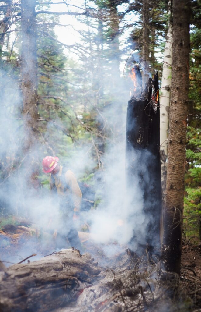
Heat lingers in heavy fuels in the higher elevation areas of the Derby Fire. The term “heavy fuel” refers to dead trees (also called snags) that are larger than 3 inches in diameter. Large stumps, standing snags and fallen logs are all included in this category.

The larger size of these dead trees makes them slow to ignite, but once smoldering, they’ll hold heat for extended amounts of time. It can take multiple weeks for them to adjust to changes to moisture levels in the atmosphere – earning them the label of “1,000 hour fuels.”

On Wednesday, August 27, 2025, firefighters worked to construct handline on the southeast side of the Derby Fire. When crews encounter burning snags as they construct control lines they use a variety of tools to extinguish the flames. S.Rawding/Derby Fire.

Derby Fire: Afternoon update

Derby Fire: Facts – August 28

Northern Rockies Complex Incident Management Team 3

Derby Fire Quick Facts: August 28, 2025
Total acreage: 5,723 acres
4% contained
824 personnel

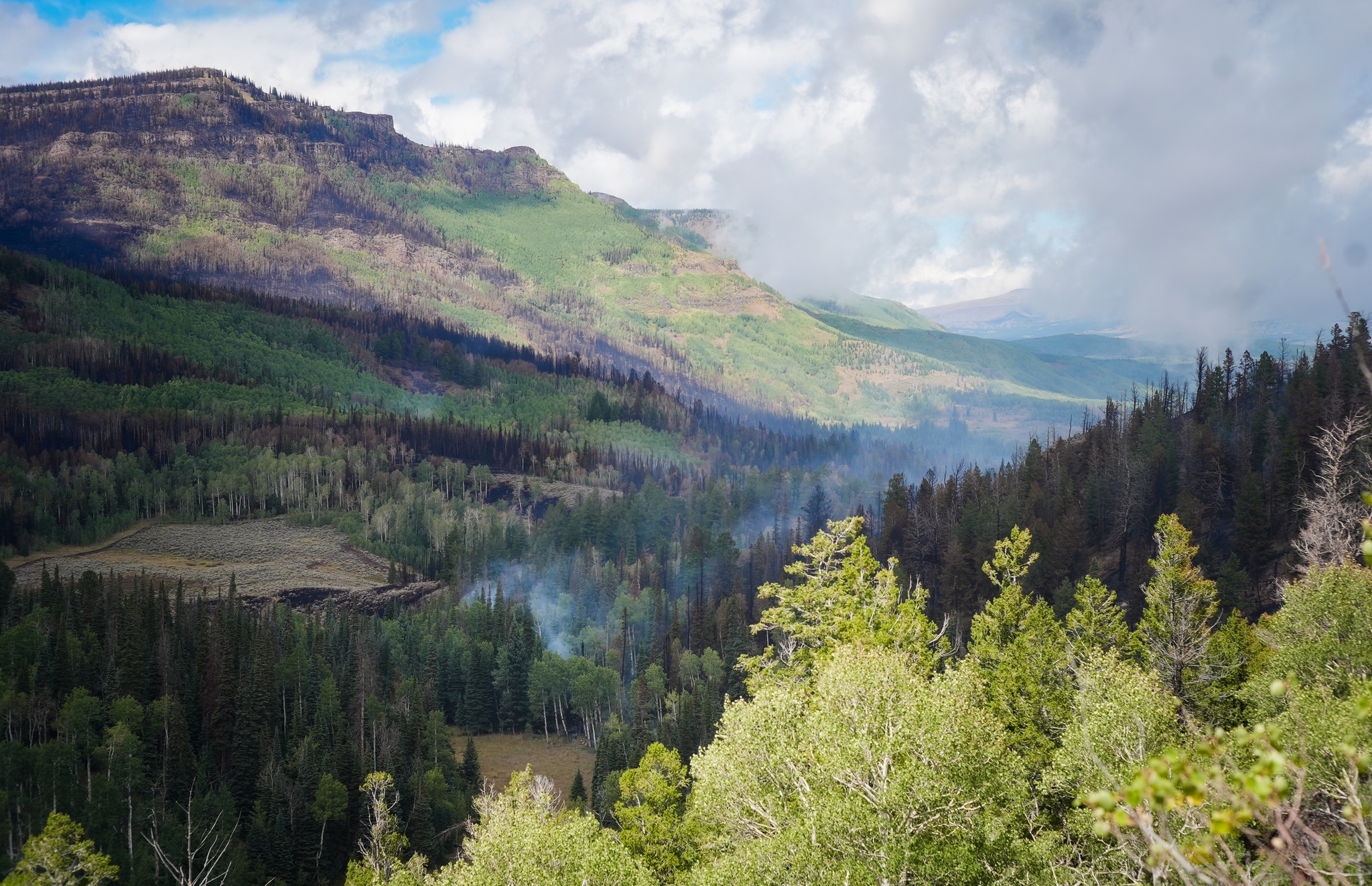
Firefighters continue to strengthen control line along the southeastern side of the fire. Within the fire footprint, smoke may be visible as sunlight rekindles isolated areas of smoldering timber. The mix of wetting and drying weather, varying winds, and patchwork fuel types lead to inconsistent fuel consumption across the incident. The rock outcrop in the rear of the photo is near the fire origin.

Photo: Looking northwest from Sugarloaf Mountain on the southeast side of the Derby Fire. S.Rawding/Derby Fire.

Derby Fire: Facts – August 28

Lee Fire: Update August 28, 2025

FDNY Incident Management Team

Incident Commander Mike Burke

Location: 11 miles south of Meeker, Colorado
Start Date: 08/02/2025
Cause: Lightning Size: Lee Fire: 137,758 acres
Containment: Lee Fire: 90%
215 Total Personnel; 9 Engines; 2 Hand Crews; 2 Water Tenders; 2 Dozers

CURRENT STATUS

Crews will continue patrols along the fire perimeter today to ensure it stays within its current footprint. Suppression repair operations are moving forward in close coordination with Resource Advisors and local agencies, following the approved Suppression Repair Plan.

Repair work is addressing areas disturbed by suppression activities, with crews working to stabilize firelines, restore ground conditions, and remove equipment no longer needed on the line. These efforts are an important step in reducing impacts and supporting long-term recovery efforts across the fire area.

Progress continues steadily as firefighters remain focused on these repair and patrol operations while working toward complete containment.

WEATHER AND FIRE BEHAVIOR

Storm chances remain in the forecast, with the highest potential for development on the southern portion of the fire. Storms are expected to track from the southwest to the northeast, with the best opportunity for development between 10:30 and 11:30 a.m. If skies clear during the late morning, storms are likely to form and bring rain, lightning, and the potential for localized flooding; if clouds remain in place, conditions may stay limited to lighter, scattered showers.

CLOSURES AND SPECIAL MESSAGES

For accurate up-to-date information on evacuations and road closures for Rio Blanco County go to the Rio Blanco County Sheriff’s Office Facebook page at: https://www.facebook.com/RioBlancoCountySheriffsOffice.

For Garfield County updates go to: https://www.garfieldcounty.net/.
USFS White River National Forest and BLM closure rescission information is available at: https://inciweb.wildfire.gov/incident…/cowrd-lee-fire

Lee Fire: Update August 28, 2025

Derby Fire: Facts – August 27

Northern Rockies Complex Incident Management Team 3

Derby Fire Quick Facts: August 27, 2025
Total acreage: 5,723 acres
2% contained
864 personnel

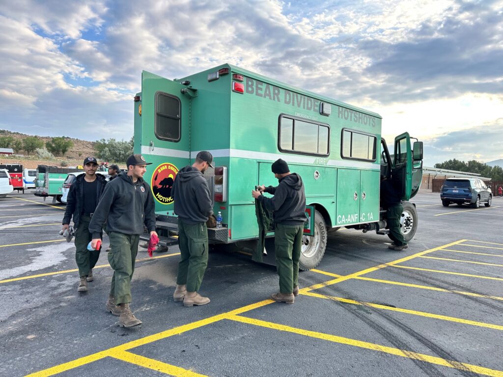
While not all Hotshot buggies are painted @U.S. Forest Service green, their shape and size is very recognizable! Hotshot crews are highly trained and specialized handcrews, often given the most physically demanding work on a large wildfire. Their transport vehicles are their “home away from home” on an incident and have just enough space for ten crew members and their gear.


Photo: The Bear Divide Hotshots from Santa Clarita, CA take care of their crew buggy and organize their gear. L.Edlund/Derby Fire.

Derby Fire: Facts – August 27

Derby Fire: Red Dirt Creek, Sweetwater, and Colorado River Roads open tomorrow

Eagle County and Garfield County Sheriff’s Offices

Garfield County zones remain in pre-evac (READY) status

News Release: 8.26.25 – Eagle/Garfield Counties – Beginning Wednesday, August 27, at 8 a.m., the Eagle County and Garfield County Sheriff’s Offices, in coordination with Derby Fire managers, will begin downgrading evacuation orders for Red Dirt Creek Road, Sweetwater Road, and Colorado River Road in phases throughout the day. After close collaboration with partner agencies and careful monitoring of conditions, these areas will move into pre-evacuation (ready) status. This allows residents to return home, but to still be prepared for risks while fire suppression continues.

“We’re extremely grateful for the work that has been accomplished by the fire crews in protecting our communities from potential devastation. Their hard work and effort are making it possible to return to a more normal pace,” said James Van Beek, Eagle County Sheriff.

Evacuation access will reopen in the following order:

Starting at 8 AM Wednesday:

All road closures will be lifted on Colorado River Road, including the closures near Coffee Pot Road and at Red Dirt Creek Road. Normal traffic will resume in both directions.

Sweetwater Road will remain closed to non-essential traffic, but a phased reentry process will begin

Sweetwater Road Reentry Schedule:

8:00 AM: Forest Service and Bureau of Land Management permit holders may begin accessing Sweetwater Road to transport gear, crews, and animals. Proof of a valid Forest Service or BLM permit will be required at the closure point.

12:00 PM: Residents may begin returning livestock and animals to their properties. An access card, proof of residency, or property ownership will be required at the closure point.

4:00 PM: The full closure on Sweetwater Road will be lifted, and the road will reopen to all traffic.

We understand how stressful and disruptive evacuations can be, and we sincerely thank our community residents for their patience and cooperation. While we are relieved to welcome residents back, it is important to remain alert and prepared.

Fire crews will remain active in the area, and heavy equipment will be positioned to provide structure protection as needed. We ask everyone to exercise extreme caution when traveling. Please yield to first responders at all times and limit non-essential movement to ensure crews have clear access to operate safely. You may find sprinklers, hoses, pumps, or water tanks on your property. Please do not move or drive over these items. If you need assistance with them, contact the Incident Management Team for help.

Recent rainfall has provided much-needed assistance in fire suppression efforts. However, with that rain comes new risks. Emergency managers are now closely monitoring for potential flooding and flash flooding in the burn area and surrounding communities.

We encourage all residents to stay aware of changing conditions, follow guidance from local authorities, and use caution when traveling through the area.

The safety of our community remains our top priority, and we are grateful for the teamwork of our partner agencies, emergency crews, and community members.

On Wednesday, the White River National Forest is reducing its public closure area. For more information, visit www.fs.usda.gov/r02/whiteriver/alerts.

***EN ESPAÑOL***

Comunicado de Noticias: 8.26.25 – Las carreteras Red Dirt Creek, Sweetwater y Colorado River volverán a abrirse el miércoles bajo estado de Preevacuación

Condados de Eagle y Garfield: A partir del Miércoles 27 de Agosto a las 8:00 a. m., las oficinas del alguacil de los condados de Eagle y Garfield, en coordinación con los gestores del incendio Derby, comenzarán a reducir las órdenes de evacuación para las carreteras Red Dirt Creek, Sweetwater y Colorado River por fases a lo largo del día. Tras una estrecha colaboración con las agencias asociadas y un cuidadoso seguimiento de las condiciones, estas zonas pasarán al estado de preevacuación (listo). Esto permite a los residentes regresar a sus hogares, pero sin dejar de estar preparados para los riesgos mientras continúa la supresión del incendio.

“Estamos extremadamente agradecidos por el trabajo realizado por los equipos de bomberos para proteger nuestras comunidades de una posible devastación. Su arduo trabajo y esfuerzo están haciendo posible volver a una vida más normal”, dijo James Van Beek, alguacil del Condado de Eagle.

El acceso para la evacuación se reabrirá en el siguiente orden:

A partir de las 8am del Miércoles:

Se levantarán todos los cierres de carreteras en Colorado River Road, incluidos los cierres cerca de la carretera Coffee Pot y en la carretera Red Dirt Creek. Se reanudará el tráfico normal en ambas direcciones.

La carretera Sweetwater permanecerá cerrada al tráfico no esencial, pero se comenzará un proceso de reentrada por fases.

Horario de reingreso a la carretera Sweetwater

8:00 AM: Los titulares de permisos del Servicio Forestal y de la Oficina de Gestión de Tierras pueden comenzar a acceder a la carretera Sweetwater para transportar equipos, personal y animales. Se exigirá la presentación de un permiso válido del Servicio Forestal o de la Oficina de Gestión de Tierras en el punto de cierre.

12:00 PM: Los residentes pueden comenzar a devolver el ganado y los animales a sus propiedades. Se requerirá una tarjeta de acceso, prueba de residencia o propiedad en el punto de cierre.

4:00 PM: Se levantará el cierre total de la carretera Sweetwater y se reabrirá en su totalidad.

Entendemos lo estresantes y disruptivas que pueden ser las evacuaciones, y agradecemos sinceramente a los residentes de nuestra comunidad por su paciencia y cooperación. Aunque nos alivia dar la bienvenida a los residentes, es importante permanecer alerta y preparados.

Los equipos de bomberos permanecerán activos en la zona y habrá maquinaria pesada para proteger las estructuras según sea necesario. Rogamos a todos que tengan extremo cuidado al trasladarse. Ceda el paso a los equipos de rescate en todo momento y limite los desplazamientos no esenciales para garantizar que los equipos tengan acceso libre para operar con seguridad. Es posible que encuentre aspersores, mangueras, bombas o tanques de agua en su propiedad. No mueva ni pase por encima de estos elementos. Si necesita ayuda con ellos, póngase en contacto con el equipo de gestión de incidentes.

Las recientes lluvias han proporcionado una ayuda muy necesaria en las labores de supresión del incendio. Sin embargo, con esas lluvias llegan nuevos riesgos. Los gestores de emergencias están ahora vigilando de cerca la posibilidad de inundaciones y riadas en la zona quemada y las comunidades de los alrededores.

Animamos a todos los residentes a que se mantengan al tanto de los cambios en las condiciones, sigan las instrucciones de las autoridades locales y tengan precaución al viajar por la zona.

La seguridad de nuestra comunidad sigue siendo nuestra máxima prioridad, y agradecemos la colaboración de nuestras agencias asociadas, los equipos de emergencia y los miembros de la comunidad.

El miércoles, el Bosque Nacional White River reducirá su área de cierre al público. Para obtener más información, visite www.fs.usda.gov/r02/whiteriver/alerts.

Derby Fire: Red Dirt Creek, Sweetwater, and Colorado River Roads open tomorrow

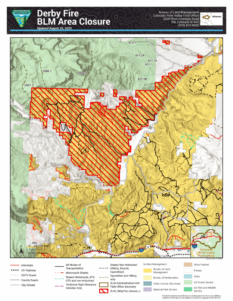
BLM reduces size of land closure in Garfield and Eagle Counties for Derby Fire

Notice of Public Closure
Press Release
Map

GRAND JUNCTION, Colo. — Today, the Bureau of Land Management issued a public land closure order to reopen some public lands in Garfield and Eagle Counties that were closed because of the Derby Fire. This modified order is effective immediately.

BLM issued the emergency closure Aug. 20 to ensure public and firefighter safety during fire suppression efforts and to reduce exposure to hazardous situations due to fire behavior of the Derby Fire.

This closure affects: BLM lands north and west of the town of Gypsum, Colorado, that are north of Sweetwater Road; west of the Colorado River; east of the White River National Forest boundary; and south of Derby Creek.

Please refer to the map on the following page and closure order (on the BLM website) for detailed information on the lands that are closed.

This order will remain in effect until fire managers declare the Derby Fire controlled or BLM rescinds the order. The public is to remain clear of the areas still closed. Please use caution and watch for firefighters when traveling in the area.

Violations of this emergency order may lead to prosecution, with fines and possible imprisonment.

We appreciate your understanding as we prioritize safety and resource integrity during this critical time. For more information about the land closure, please call the Colorado River Valley Field Office front desk at 970-876-9000. For more information about the Derby Fire, please call the fire information line at 970-355-3283.

BLM reduces size of land closure in Garfield and Eagle Counties for Derby Fire

Lee Fire: Daily update August 26

FDNY Incident Management Team

Incident Commander Mike Burke

Lee Fire update document

Location: 11 miles south of Meeker, Colorado
Start Date: 08/02/2025
Cause: Lightning Size: Lee Fire: 138,844 acres
Containment: Lee Fire: 90%
208 Total Personnel; 1 Helicopter; 10 Engines; 1 Hand Crew; 1 Water Tender; 2 Dozers

KEY MESSAGE
Today, crews are continuing repair work in areas affected by suppression activities, following agency standards and working closely with Resource Advisors. These efforts aim to reduce the impacts of firefighting operations while protecting important natural and cultural resources. Fireline is being restored to local and agency standards, and patrols are underway to ensure the fire remains secure within its current footprint. Suppression repair operations will continue under the approved Suppression Repair Plan, minimizing impacts and supporting progress toward full containment

CURRENT STATUS
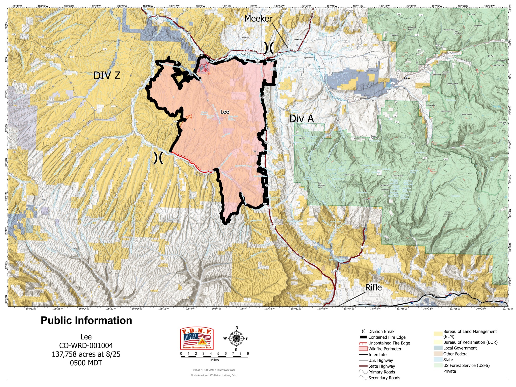
Yesterday, the FDNY Incident Management Team formally assumed command of the Lee Fire. Updated acreage was reported following the most recent infrared flight, which was completed after several earlier cancellations due to unfavorable weather conditions. This flight provided a clearer picture of current fire activity and perimeter status. Across all divisions, crews continued suppression repair, and debris removal, working closely with Resource Advisors to mitigate impacts and restore affected areas. These efforts remain a priority as containment objectives progress and conditions allow.

WEATHER AND FIRE BEHAVIOR
The monsoonal pattern remains firmly in place, with rainfall probabilities near 100% over the coming days. Widespread cloud cover with embedded showers is moving across the area. Should clearing occur by midday, stronger thunderstorms are likely to develop, increasing the potential for flash flooding. If cloud cover persists, conditions remain limited to lighter, intermittent rain with minimal lightning or heavy downpours.

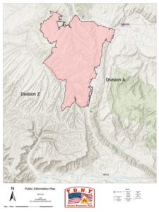
lee fire map 8-26-25

CLOSURES AND SPECIAL MESSAGES
For accurate up-to-date information on evacuations and road closures for Rio Blanco County go to the

Rio Blanco County Sheriff’s Office Facebook page
For Garfield County updates go to: https://www.garfieldcounty.net/
USFS White River National Forest and BLM closure rescission information is available
Lee Fire: Daily update August 26

Derby Fire: Facts – August 26

Northern Rockies Complex Incident Management Team 3

Derby Fire Quick Facts: Tuesday, August 26, 2025
Total acreage: 5,346 acres
0% containment
844 personnel

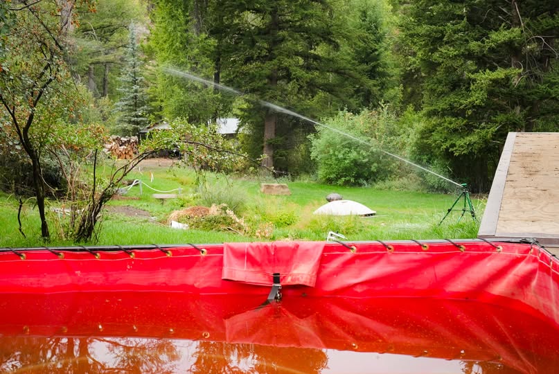
Firefighters tested structure protection systems yesterday in the Sweetwater Canyon area. In this photo, a sprinkler wets down the lawn of a resident, drawing water from a foldable water tank. The water tanks are filled by fire engines or water tenders.

Pumps push the water from the water tank through hose lays to the sprinkler systems. Photo by Stephen Rawding/Derby Fire.

Derby Fire: Facts – August 26

NWS: A strong thunderstorm will impact south central Garfield County

National Weather Service

Roan and Tavaputs Plateaus CO-Debeque to Silt Corridor CO-151 PM MDT Mon Aug 25 2025

Map of area

A strong thunderstorm will impact south central Garfield County through 2:15 p.m. MDT

At 1:51 p.m. MDT, Doppler radar was tracking a strong thunderstorm 18 miles northwest of De Beque, or 28 miles north of Grand Junction, moving east at 10 mph.

HAZARD
Wind gusts up to 40 mph and penny size hail.

SOURCE
Radar indicated.

IMPACT
Gusty winds could knock down tree limbs and blow around unsecured objects. Minor hail damage to vegetation and outdoor objects is possible.

This storm will remain over mainly rural areas of south central Garfield County.

PRECAUTIONARY/PREPAREDNESS ACTIONS

If outdoors, consider seeking shelter inside a building.

NWS: A strong thunderstorm will impact south central Garfield County