Issued for western Eagle and eastern Garfield Counties Issued at 7:56 AM MDT, Thursday, August 21, 2025
Issued by the Colorado Department of Public Health and Environment
Affected Area: Western Eagle and eastern Garfield Counties. Locations include, but are not limited to Sweetwater Lake, Dotsero, Gypsum, and Eagle.
Advisory in Effect: 9:00 AM MDT, Thursday, August 21, 2025 to 9:00 AM MDT, Friday, August 22, 2025
Public Health Recommendations: If smoke is thick or becomes thick in your neighborhood you may want to remain indoors. This is especially true for those with heart disease, respiratory illnesses, the very young, and older adults. Consider limiting outdoor activity when moderate to heavy smoke is present. Consider relocating temporarily if smoke is present indoors and is making you ill. If visibility is less than 5 miles in smoke in your neighborhood, smoke has reached levels that are unhealthy.
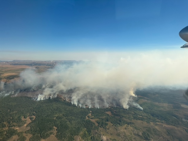
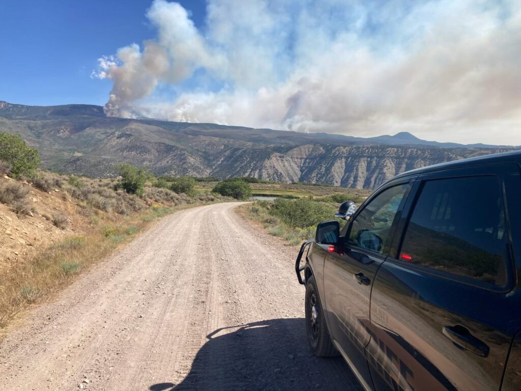
Outlook:Smoke from the Derby Fire is impacting central Colorado. The heaviest smoke is expected in areas near the fire and in low-lying areas.
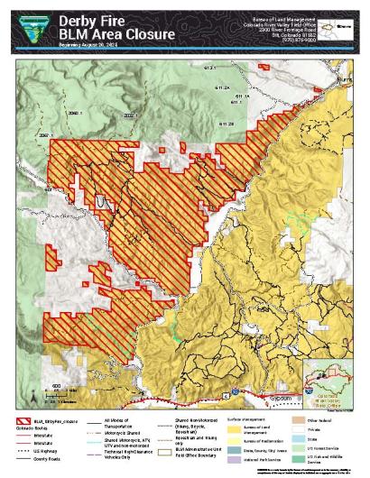
GRAND JUNCTION, Colo. — Today, the Bureau of Land Management issued an order closing BLM-managed public lands in Garfield and Eagle Counties because of the Derby Fire. BLM issued the emergency closure to keep the public and firefighters safe while fire activity is in the area. The order is effective immediately and the closure will remain until fire managers declare the Derby Fire controlled or BLM rescinds the order.
This closure affects BLM lands north and west of the town of Gypsum, Colorado, that are north of Coffee Pot Road; west of the Colorado River; east of the White River National Forest boundary; and south of Derby Creek.
Please refer to the map below and closure order (on the BLM website) for detailed information on the lands that are closed.
The temporary closing of the lands is to reduce exposure to hazardous situations due to the recent, rapid rates of spread and fire behavior of the Derby Fire. The public is to remain clear of these closed lands. Please use caution and watch for firefighters when traveling in the area.
Violations of this emergency order may lead to prosecution, with fines and possible imprisonment.
We appreciate your understanding as we prioritize safety and resource integrity during this critical time. For more information about the land closure, please call the Colorado River Valley Field Office front desk at 970-876-9000. For more information about the Derby Fire, please call the fire information line at 970-355-3283.
Northern Rockies Complex Incident Management Team 3
Overnight, diurnal wind increased fire behavior. The fire was active through the night increasing along the southern edge. Today, fire behavior was reduced with the lack of wind. We expect to have accurate acreage tomorrow after the infrared flight tonight.
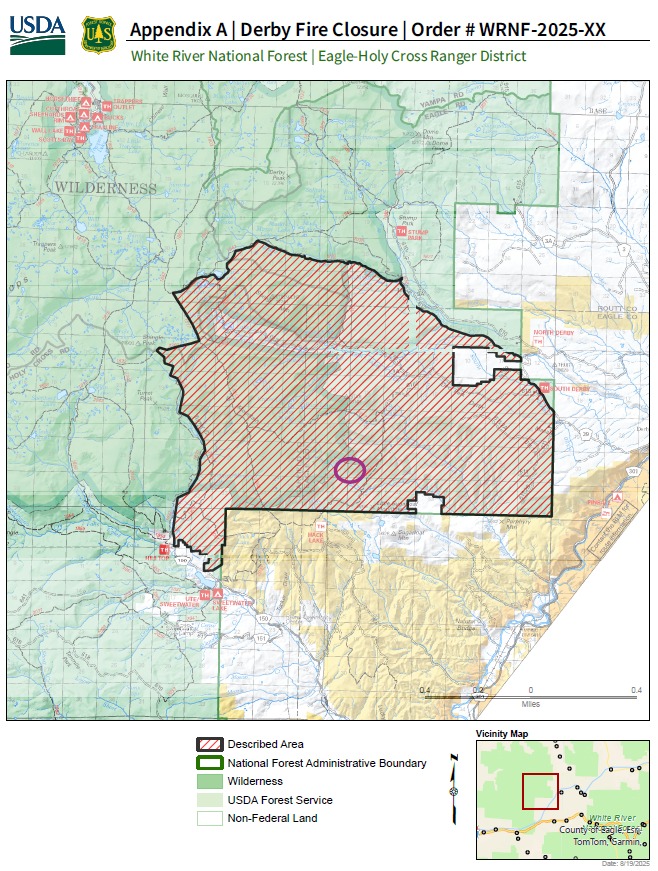
TEMPORARY AREA CLOSURE ORDER USDA FOREST SERVICE WHITE RIVER NATIONAL FOREST SYSTEM LANDS RESTRICTION EAGLE-HOLY CROSS RANGER DISTRICT
For the protection of health and safety to the public pursuant to 16 USC 551 and 36 CFR 261.50 (a) and (b), the following acts are prohibited within the White River National Forest, Blanco and Eagle-Holy Cross Ranger Districts, Eagle and Garfield counties, in the State of Colorado.
The restricted area is further defined as the area on National Forest System lands within the Blanco and Eagle-Holy Cross Ranger Districts located, starting north of Sweetwater Lake, following the Forest boundary north and east to the intersection of the Derby Loop Road (Eagle County Road 39). Then follow Middle Derby Creek generally northwest to Island Lakes. Then, generally south following the Island Lakes Trail (#1842), the W Mountain Trail (#1817), the Turret-Crescent Trail (#2269) and the Turret Creek Trail (#1838) back to Sweetwater Lake.
The following roads are located within the closure: National Forest System Roads 609.1; 611.1; 611.2A; 611.2B; 613.1; 613.1A; 616.1.
The following trails are located within the closure: Nellies (#1839); Johnny Meyers (#2067); Ute-Sweetwater (#2032); South W (#2060); W Mountain Trail (#1817) between Big Spring and Turret-Crescent Trail (#2269); Roberts Trail (#2076).
The attached map (Appendix A) shows the area of temporary closure order.
PROHIBITIONS:
Going into or occupying the temporary area closure within the National Forest System lands until order closure order is rescinded. See Attached Map. 36 C.F.R. 261.53(e)
EXEMPTIONS:
Pursuant to 36 C.F.R 261.50(e), the following persons are exempt from this order:
Any Federal, State, or local officer, or member of an organized rescue or firefighting force in the performance of an official duty;
Persons with a Forest Service permit specifically authorizing the otherwise prohibited act or omission.
This order shall remain in effect until rescinded or until December 31, 2025, whichever event occurs first.
Done at Glenwood Springs, this 19th day of August 2025
Northern Rockies Complex Incident Management Team 3
The Northern Rockies Complex Incident Management Team 3 assumed command of the Derby Fire at 6:00 a.m. today. It is currently estimated at over 839 acres. More resources are arriving on-scene.
Here is an operational update and more information will be forthcoming throughout the day.
GO (RED) EVACUATE zone 265 by noon today, including Sweetwater, Sweetwater Lake and CR 150 Road and sections of Colorado River Road from Sweetwater to Red Dirt Creek, both in Eagle and Garfield counties.
SALIR (ROJO) EVACUAR zona 265 al mediodía de hoy, incluyendo Sweetwater, Sweetwater Lake y CR 150 Road y secciones de Colorado River Road desde Sweetwater hasta Red Dirt Creek, ambos en los condados de Eagle y Garfield.
The Derby Fire started on 8/17/2025. The small, lightning-ignited fire was detected on a steep cliff above the West Fork of Red Dirt Creek late Sunday morning.
8.20.25, 7:45 a.m. – Evacuation Notice: Significant fire growth on the Derby Fire overnight.
Residents of Sweetwater Rd and areas of the Colorado River Rd from Sweetwater to Red Dirt Creek must leave the area by 12pm noon Wed, 8/20.
Derby Mesa Loop remains in pre-evacuation at this time.
An Evacuation Center is open and located at: – Two Rivers Community Center, 80 Lake Shore Drive, Dotsero. We are not accepting or in need of any donations at this time.
Livestock and animal evacuation support, please contact Connie Melzer of CSU Extension, 970-471-8043.
For support with smaller animals, dogs and cats, please call the Eagle County Animal Services #970-328-3647 and press 2.
More information and resources will be shared here on ECEmergency.org.
Información de seguridad pública del condado de Eagle
El incendio Derby comenzó el 17/8/2025. El pequeño incendio, originado por un rayo, se detectó en un acantilado escarpado sobre la bifurcación oeste del arroyo Red Dirt la madrugada del domingo.
8.20.25, 7:45 am – Aviso de evacuación: Crecimiento significativo del incendio en el incendio Derby durante la noche.
Los residentes de Sweetwater Rd y áreas de Colorado River Rd desde Sweetwater hasta Red Dirt Creek deben abandonar el área antes del mediodía del miércoles 20 de agosto.
Derby Mesa Loop permanece en pre-evacuación en este momento.
Hay un Centro de Evacuación abierto en el Centro Comunitario Two Rivers, 80 Lake Shore Drive, Dotsero. En este momento NO estamos aceptando ni necesitando donaciones.
Para recibir apoyo de evacuación de ganado y animales, comuníquese con Connie Melzer de CSU Extension, 970-471-8043.
Para obtener ayuda con animales más pequeños, perros y gatos, llame a los Servicios para Animales del Condado de Eagle al # 970-328-3647 y presione 2.
Se compartirá más información y recursos aquí en ECEmergency.org .
August 15, 2025, 6:26 p.m. – Important fire safety update:
The below press release from the U.S. Forest Service – Routt National Forest contains important information for anyone recreating in our area. Parts of Garfield County fall within the Routt National Forest, so please take a moment to read through the details before you head out.
Let’s all do our part to protect our beautiful lands and keep our community safe.
United States Forest Service
Sections of Routt National Forest are in Garfield County
Severe conditions put Routt National Forest in Stage 2 fire restrictions
Campfires are not allowed under these restrictions.
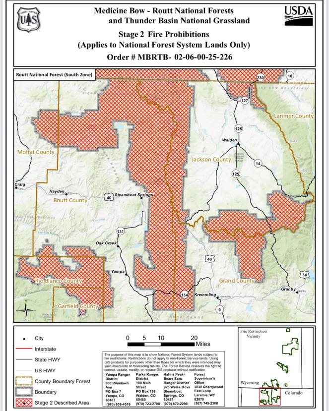
(LARAMIE, Wyo.) August 15, 2025 – Effective immediately, Stage 2 fire restrictions are in place for the Routt National Forest in northwest Colorado.
This includes National Forest System lands located in Garfield, Grand, Jackson, Moffat, Rio Blanco, and Routt counties.
The U.S. Department of Agriculture, Forest Service has communicated with all affected counties, state agencies, and neighboring federal land managers on the timing of the restrictions.
All criteria have been met for the Forest to move into Stage 2 restrictions and the USDA Forest Service is aligned with surrounding land managers regarding this action. Tightened restrictions are necessary due to extreme, dry fuel conditions that are receptive to fire, persistent fire weather patterns, and the danger of human-caused wildfires. Recent weather conditions have resulted in an elevated potential for wildfires. Fire restrictions will help protect public health and safety, as well as natural resources.
The Routt National Forest was last in Stage 2 restrictions in 2020 and has been in Stage 1 restrictions since July 10 of this year.
The following prohibitions are in effect until further notice:
Igniting, building, maintaining, attending, or using a fire, campfire, charcoal barbecue, or grill, except if using a device solely fueled by liquid or gas that can be turned on and off in an area barren or cleared of all flammable materials within three feet of the device.
Smoking, except in an enclosed vehicle or building.
Welding or operating an acetylene or other torch with open flame.
Using an explosive.
This includes but is not limited to fuses, blasting caps, fireworks, rockets, exploding targets, tracers, and incendiary ammunition.
Possessing or using a motor vehicle off NFS roads, except when parking in an area devoid of vegetation within 10 feet of the motor vehicle.
Personal, portable wood or charcoal burning fire pits/rings, often made of stainless steel, are not allowed under these restrictions. Only gas-fueled devices with an on/off switch may be used.
Operating or using any internal or external combustion engine without a spark arresting device that is properly installed, maintained, and in effective working order in accordance with USDA Forest Service Standard 5100-1.
For chainsaw use, it is recommended the operator have a chemical pressurized fire extinguisher (with a minimum 8 oz. capacity and rating of 2A) and a round point shovel with an overall length of at least 35 inches readily available for use.
Violation of the Stage 2 Fire Prohibitions is punishable as a Class B misdemeanor by a fine of not more than $5,000 for individuals and $10,000 for organizations, or by imprisonment for not more than six months, or both. Anyone negligently or willfully starting a wildland fire could also be held responsible for the costs of that fire.
Forest staff will continue to monitor conditions to assess the need for further action, including additional restrictions if weather remains hot and dry and lessening restrictions if a wetter and cooler weather pattern develops.
To report a wildland fire, please call the Northern Colorado Interagency Dispatch Center, (970) 295-6800.
Call your local office for site-specific information.
Hahns Peak/Bears Ears Ranger District, Steamboat Springs, Colo., (970) 870-2299
Parks Ranger District, Walden, Colo., (970) 723-2700
Information on the Medicine Bow-Routt National Forests and Thunder Basin National Grassland can be found on our website or on the Forests’ ‘X’ and Facebook accounts.