Garfield County Emergency Communications Authority
4.11.24, 10:38 a.m. – Highway 82 is open at mile marker 8 westbound.
4.11.24, 9:29 a.m. – Highway 82 is closed at mile marker 8 westbound, due to an accident.
REGISTER for emergency alerts at garco911.com
SUBSCRIBE for emails from this feed - click at upper right
VIEW: Inciweb wildfires | CDOT routes | NOAA storms | CAIC avalanches

Garfield County | Accessibility | Storm King 14
4.11.24, 10:38 a.m. – Highway 82 is open at mile marker 8 westbound.
4.11.24, 9:29 a.m. – Highway 82 is closed at mile marker 8 westbound, due to an accident.
March 7, 11:32 a.m. – Statewide — Eastbound Interstate 70 in Glenwood Canyon has reopened after a safety closure, due to a rockslide at mile point 123.5. The slide came down onto the outside westbound lane. All lanes were closed as a safety precaution. One lane of westbound I-70 is anticipated to reopen shortly. CDOT’s Geohazards team is en route to further assess the slope above the roadway.
The slide took place at approximately 10 a.m. this morning, and is located between Grizzly Creek (exit 121) and Hanging Lake (exit 125). The slide is located east of Glenwood Springs. See below for more photos. The slide is mostly rock. Crews immediately began clearing the slide with prepositioned equipment and are making good progress on clearing the roadway. CDOT anticipates crews will be able to quickly clear the slide from the roadway. An alternate route is not recommended at this time.
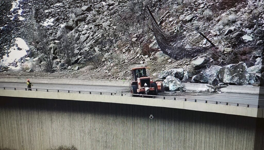
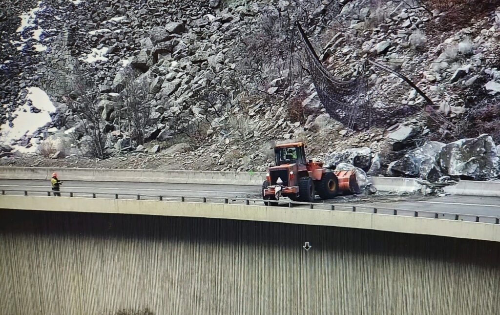
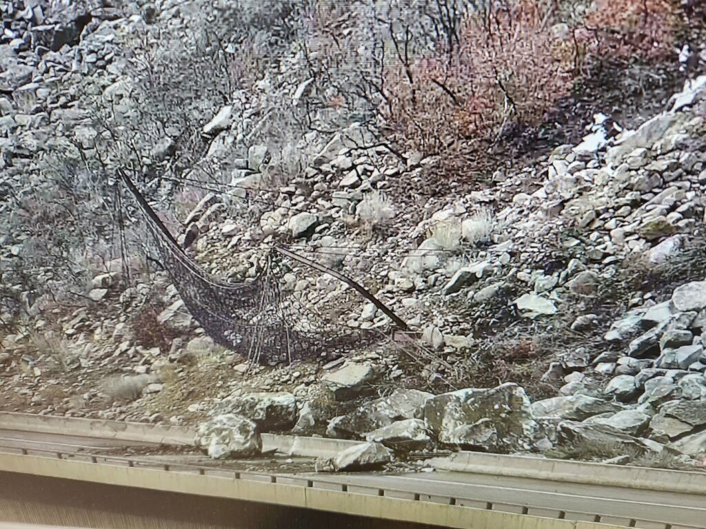
March 7, 2024, 11:36 a.m. – Interstate 70 has reopened to traffic in both directions.
March 7, 2024, 10:37 a.m. – Interstate 70 eastbound/westbound is closed due to a rockslide that occurred between exit 123 – Shoshone and Exit 125 – Hanging Lake. Road closed between MM 116 (Glenwood Springs) and MM 133 (Dotsero) expect delays
UPDATE 2.8.24, 8:32 a.m. – Today at 8:43 AM, Google reported a 5 min delay Eastbound. Between Exit 119: No Name and Exit 121: Grizzly Creek (1 mile east of No Name) from Mile Point 120 to Mile Point 120.5. The left lane is closed due to a crash. Slower speeds are advised.
2.8.24, 6:25 a.m. – I-70 is closed at mile-marker 116 eastbound, main Glenwood exit, due to an accident in Glenwood Canyon.
12.24.23, 11:07 a.m. – I-70 is open at mile-marker 116 eastbound (toward Denver).
12.24.23, 10:53 a.m. – I-70 is closed at mile-marker 116 EB, 116 eastbound (toward Denver), due to an incident.
12.8.23, 2:41 p.m. – Between exit 114: West Glenwood (Glenwood Springs) and Exit 129: Bair Ranch (7 miles west of Dotsero) from Mile Point 116 to Mile Point 126. Road closed expect delays due to a crash.
Comment: Pileup eastbound at Hanging Lake Tunnel. I-70 closed at Glenwood Springs.
Check CDOT cotrip for closures for updates when traveling.
12-8-23, 12:50 p.m. – Comment: At least 18 vehicles involved in pileup.
12-8-23, 11:13 a.m. – Interstate 70 is closed westbound between Exit 72: West Parachute (2 miles west of Parachute) and Exit 62: De Beque (De Beque) from Mile Point 72 to Mile Point 62. Road closed expect delays due to a crash.
I-70 through Glenwood Springs is completely open now. The collision scene has been cleared. Travel cautiously in the current severe weather conditions.
12-8-23, 11:39 a.m. – At Exit 114: West Glenwood (Glenwood Springs) at Mile Point 114.2. Road closed expect delays due to a crash. Slower speeds are advised.
Comment: Eastbound traffic being diverted around crash using the Exit 114 off-ramp and on-ramp.
12-8-23, 10:49 a.m. – Interstate 70 is closed in both directions in South Canyon between Exit 114: West Glenwood and Exit 111: South Canyon (Glenwood Springs) at Mile Point 114. Road closed expect delays due to a crash. Slower speeds are advised.
September 20, 2023, 3:26 p.m. – Interstate 70 is open at mile-marker 133, westbound, Dotsero.
September 20, 2023, 2:22 p.m. – Interstate 70 is closed at mile marker 133 westbound, Dotsero, due to an accident.
Aug. 27, 2023, 12:39 a.m. – Interstate 70 open between mile markers 116 and 133 in both directions, Glenwood Springs to Dotsero.
Aug. 26, 2023, 5:22 p.m. – I-70 is closed between mile markers 116-133, in both directions, Glenwood Springs to Dotsero, due to a flash flood warning.
8.25.23, 12:44 am: I-70 is open between mile markers 116-133 both directions, Glenwood Springs and Dotsero.
UPDATE I-70 Glenwood Canyon is open – 12:35 AM (8/25) – I-70 Glenwood Canyon all lanes are open.
UPDATE I-70 Glenwood Canyon remains closed – 9:55 PM (8/24) – Crews are performing a sweep of the canyon after the Flash Flood Warning was lifted around 9 p.m. The team is clearing debris and standing water in the eastbound lanes. There currently is no estimated time for reopening.
I-70 Glenwood Canyon CLOSED – 6:30 PM (8/24) – I-70 in Glenwood Canyon is closed due to a Flash Flood Warning for the Grizzly Creek burn scar area. **All updates will continue to be posted to cotrip.org, CDOT’s Twitter page, and available by dialing 511.**
Closure points for all traffic are Exit 133 (Dotsero), Exit 116 (Glenwood Springs), Exit 109 (Canyon Creek) and Exit 87 (West Rifle). The I-70 closure will stay in place through the Warning and then crews will review whether the canyon is safe to reopen. At this time the Flash Flood Warning is in effect until 9:00 p.m. per the National Weather Service.
8.24.23, 6:22 pm: I-70 is closed between mile markers 116 and 133 both directions, Glenwood Springs and Dotsero, due to a flash flood warning.
Flash Flood Warning
COC037-045-250300-
/O.NEW.KGJT.FF.W.0010.230825T0012Z-230825T0300Z/
/00000.0.ER.000000T0000Z.000000T0000Z.000000T0000Z.OO/

BULLETIN - EAS ACTIVATION REQUESTED
Flash Flood Warning
National Weather Service Grand Junction CO
612 PM MDT Thu Aug 24 2023

The National Weather Service in Grand Junction has issued a

* Flash Flood Warning for...
  The Grizzly Creek Fire Burn Area in...
  Western Eagle County in west central Colorado...
  East Central Garfield County in west central Colorado...

* Until 900 PM MDT.

* At 612 PM MDT, Doppler radar indicated thunderstorms producing
  heavy rain over the Grizzly Creek Fire Burn Area. Flash flooding
  is ongoing or expected to begin shortly.

Excessive rainfall over the burn scar will result in debris flow
moving through the Glenwood Canyon area. The debris flow can consist
of rock, mud, vegetation and other loose materials.

  HAZARD...Life threatening flash flooding. Thunderstorms
           producing flash flooding in and around the Grizzly
           Creek Fire Burn Area.

  SOURCE...Radar.

  IMPACT...Life threatening flash flooding of areas in and around
           the Grizzly Creek Fire Burn Area.

* Some locations that will experience flash flooding include...
  Glenwood Springs and Shoshone.

PRECAUTIONARY/PREPAREDNESS ACTIONS...

This is a life threatening situation. Heavy rainfall will cause
extensive and severe flash flooding of creeks...streams...and
ditches in the Grizzly Creek Fire Burn Area. Severe debris flows can
also be anticipated across roads. Roads and driveways may be washed
away in places. If you encounter flood waters...climb to safety.

Turn around, don`t drown when encountering flooded roads. Most flood
deaths occur in vehicles.

&&

LAT...LON 3965 10722 3967 10720 3965 10713 3963 10712
      3965 10709 3963 10707 3961 10711 3958 10708
      3957 10711 3955 10714 3954 10720 3954 10724
      3956 10731 3963 10729 3963 10726 3964 10725

FLASH FLOOD...RADAR INDICATED
FLASH FLOOD DAMAGE THREAT...CONSIDERABLE