GARFIELD COUNTY SHERIFF’S OFFICE – An IPAWS message sent by Moffat County was received by some residents in Garfield County and included information about lifted evacuations. This is NOT related to the Lee Fire and no statuses in Garfield County have changed.
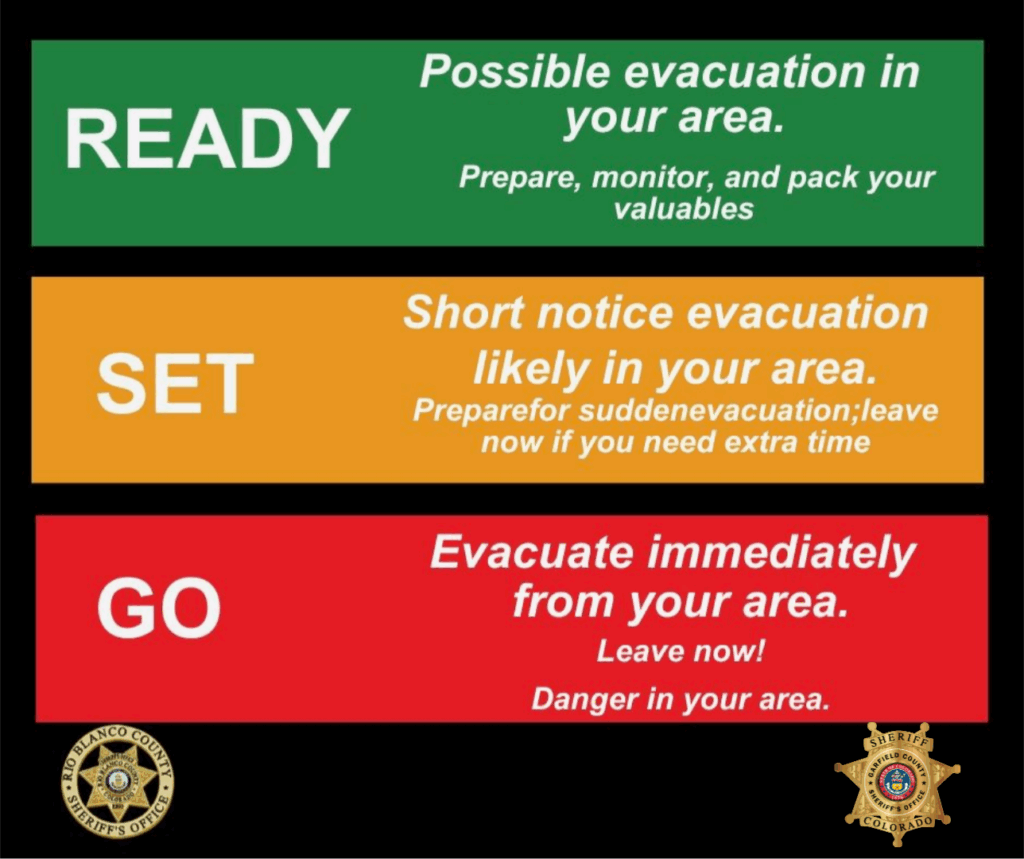
Current status by zone is as follows: Zone 70-GO Zones 71/80/81-SET Zones 72/73-READY
You will receive another message if your zone status is changed.
Garfield County Emergency Communications Authority
We’ve had lots of questions about the #GarCo911 Emergency Alerting System, so here’s what you should know:
Purpose – Alerts are sent only for serious threats to life or safety, when you need to take action (evacuate, shelter in place, avoid an area). The only exception is opt-in community messages like road closures or air quality updates. Alerts are not for general updates or information.
How It Works – Using geotargeting, alerts go to people with addresses in their Everbridge account identified as being affected by responders on scene. This may be a radius from an address or a shape drawn onto a map to capture specific roads, subdivisions, or areas described by responders.
Caller ID Tip – Messages won’t show “911” on caller ID. Save the number that sends you alerts in your contacts as GarCo911 so you recognize it.
IPAWS Alerts – Like Amber Alerts, these target phones near an incident using cell towers. It’s not perfect—some outside the area may get them, some inside may not. Make sure Emergency and Public Safety Alerts are ON in your phone settings.
Read the Whole Message – We always include location details so you can tell if it affects you.
No Service or Internet? – IPAWS alerts also play on AM radio via the National Weather Service.
Garfield County Emergency Communications Authority
Follow official sources
8.10.25, 3:00 p.m. – We know many people use WatchDuty to follow wildfire activity. It’s a fantastic tool for situational awareness, and we appreciate the dedicated volunteers who help keep it updated.
However, WatchDuty is a third-party app — meaning it is not an official emergency alert source. While it’s great for general awareness, the information is not verified by official sources and may be delayed or incomplete.
Emergency Notifications come directly from your local 911 center in coordination with responders on the ground. These alerts are:
Official and verified
Issued only for serious, confirmed threats to life or safety
Designed to tell you exactly what action to take (evacuate, shelter in place, avoid an area, etc.)
Bottom line:
WatchDuty can be used to monitor developing situations but should NOT be used in place of official, local sources. Be aware that information may not be timely, accurate, complete, and that things like maps are not coming directly from the official source.
Sign up for emergency notifications at garco911.com, follow @GarCo911 and @GarcoSheriff as well your local Police Department social media page, and check the Garfield County Emergency Operations Center website (www.garfieldcounty.net) for official instructions you can trust when seconds matter.
Make sure your Everbridge account is up to date and that Emergency and Public Safety Alerts are ON in your phone settings so you don’t miss critical messages.
Size: Elk Fire: 14,502 acres | Lee Fire: 88,755 Containment: Elk Fire: 8% | Lee Fire: 0% Total Personnel: 1,245 Cause: Lightning Resources: 13 Aircraft | 62 Engines | 21 Hand Crews | 13 Heavy Equipment Important Notes: All updates related to the Elk and Lee Fires will be posted at: https://www.facebook.com/elkleefire/.
Road closures and evacuation notices for Rio Blanco County will still be posted on the Rio Blanco Sheriff Facebook Page at https://www.facebook.com/RioBlancoCountySheriffsOffice.
Evacuation information for Garfield County will be posted on the Garfield County Sheriff’s Facebook page at https://www.facebook.com/GarcoSheriff.
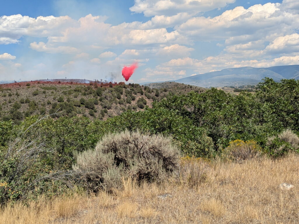
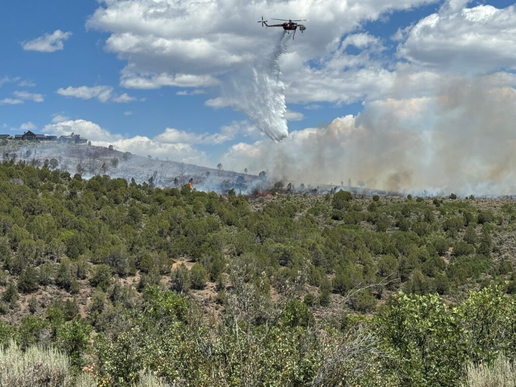
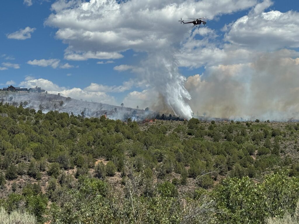
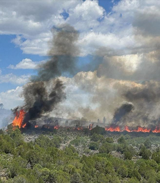
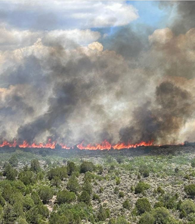
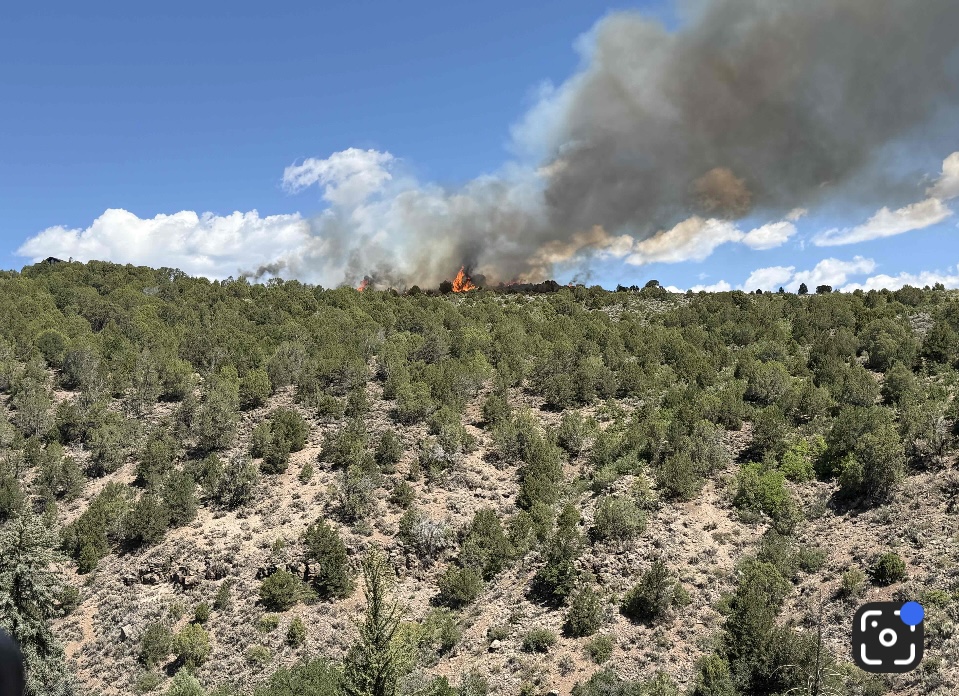
Yesterday: Lee Fire – Pyrocumulus clouds developed as a result of extreme fire behavior induced by high winds and extremely dry vegetation. It moved rapidly to the southeast, resulting in some spotting across CR 5. The fire did not cross into Garfield County however, the increase in activity initiated pre-evacuations in Garfield County. Aerial resources were utilized in the morning until increased winds in the early afternoon impacted the accuracy of water drops and eventually grounded the aircraft. Fire resources worked through the night to protect structures along CR 5. Firefighters conducted point protection around structures utilizing engines and dozers through the night.
Elk Fire: Smoke from the Lee Fire shaded the Elk Fire and reduced fire behavior allowing firefighters to further reinforce firelines. Structure protection resources continued monitoring and reinforcing around structures through the night.
Current Situation: Lee Fire – Firefighter and aerial resources are focusing on the spotting that occurred across CR 5 to contain the spots and keep the fire from spreading toward Hwy 13 and into Garfield County. Fire resources will continue structure protection around homes and other values at risk. Firefighters are patrolling and mopping up hot spots along the perimeter on the Hogback ridge.
Elk Fire: Firefighters will continue patrol and mop up containment lines to keep the fire from further spread. Structure protection resources will remain in place around residences and other values at risk. Weather & Fire Behavior: A Red Flag Warning is in effect from 11:00 a.m. – 8:00 p.m. Temperatures will range in the low to mid-80’s. Humidity’s will fall in the low teens. Winds will shift to the north/northeast mid-morning until early evening. These weather conditions along with the dry fuels are conducive to extreme fire behavior.
Evacuations and closures: Go to the Rio Branco County Sheriff’s Office Facebook page – https://www.facebook.com/RioBlancoCountySheriffsOffice – for accurate up-to-date information on all evacuations and road closures. To sign up for emergency alerts at: https://rioblancoalerts.genasys.com/portal/en.
For Garfield County go to: https://www.garfieldcounty.net/. White River National Forest closure information at: https://www.fs.usda.gov/r02/whiteriver/alerts. BLM White River Field Office closures information at: https://www.blm.gov/announcement/blm-colorado-issues-emergency-closure-public-lands-rio-blanco-county. Air Quality: Current air quality for your area can be found at fire.airnow.gov.
Elk and Lee Fire Information: Phone: 970-341-8665; Email: 2025.elkrbx@firenet.gov Facebook: www.facebook.com/elkleefire Iniciweb Lee Fire: https://inciweb.wildfire.gov/incident-information/cowrd-lee-fire Inciweb Elk Fire: https://inciweb.wildfire.gov/incident-information/cowrd-elk-rbx-fire
New zones moved to SET status
8.9.25, 10:01 am – Zones 70 and 71: Due to the Lee Fire, you are in SET status. Prepare for sudden evacuation orders issued by Garfield County Sheriff’s Office. You will receive another message if you are updated to GO status. Check your zone on this map.
Carbondale & Rural Fire Protection District, Garfield County Sheriff’s Office, Garco911, CDPHE
Carbondale & Rural Fire Protection District
Coulter Creek Fire final update
PRESS RELEASE 8.4.25, 4:19 p.m. – Firefighters have concluded their work on the Coulter Creek Fire. The fire is 100 percent contained.
Firefighters will continue to patrol the fire area over the next few days to watch for any remaining hot spots or flare ups.
County Road 113 between County Road 100 and County Road 121 has reopened.
The investigation into the cause of the fire is ongoing and the official cause is expected to be determined in the next few days. However, lightning in the area a few days before the fire started is believed to be the likely cause.
“The quick actions of firefighters combined with the support of air resources stopped this fire before it could cause greater damage,” said Fire Chief Rob Goodwin. “This was a strong team effort that demonstrates the value of our mutual aid partnerships and the training our crews do year round to prepare for these situations. I am grateful there were no injuries and no homes were lost in this fire.”
This is the final update on the Coulter Creek Fire unless conditions change.
PRESS RELEASE 8.4.25, 10 a.m. – Firefighters are on scene at the Coulter Creek Fire today. Their assignment is to construct containment lines and to cold trail the fire. The fire size has been updated to 107 acres with 20 percent containment.
Cold trailing is a mop up technique used to make sure the fire is completely out. Firefighters carefully inspect and feel along the fire’s edge to detect any remaining heat or hot spots.
Aggressive firefighting on the ground, along with water and retardant drops from the air, stopped the fire’s spread yesterday.
While the fire is only 20 percent contained, that number reflects that there is not yet a complete control line – whether dug by hand or created with a wetline – around the fire.
Once cold trailing is complete, firefighters will be able to provide an updated containment number. Crews expect to finish mop up operations today and achieve 100 percent containment.
County Road 113 remains closed between County Road 100 and County Road 121, but is expected to be opened later today.
Carbondale, Colo. – The Coulter Creek Fire is currently estimated at 115 acres with 0 percent containment.
Evacuation orders have been lifted. County Road 113 will remain closed between County Road 100 and County Road 121.
Firefighters will remain on scene overnight to monitor the fire. In the morning, crews will focus on cold trailing the fire. Cold trailing is a mop-up technique used to ensure the fire is fully extinguished by carefully inspecting and feeling along the fire’s edge to detect any remaining heat or hot spots.
No homes were lost, though one outbuilding was destroyed in the fire. No injuries have been reported. The cause is under investigation by Carbondale Fire’s investigation team, but is not believed to be suspicious.
“Firefighters on the ground worked aggressively to build fireline and protect homes while air crews made repeated water and retardant drops to slow the fire’s spread,” said Incident Commander Bill Gavette. “This was a true team effort. Ground crews worked with air crews attacking the fire from multiple angles. That coordinated response was key to stopping the Coulter Creek Fire.”
Assisting agencies included Roaring Fork Fire, Aspen Fire, Glenwood Springs Fire, Grand Valley Fire, Eagle River Fire, Vail Fire, Summit Fire EMS , Red, White, and Blue Fire Protection District, Steamboat Springs Fire, Garfield County Sheriff, Eagle County Sheriff, Pitkin County Emergency Management, Garfield County Emergency Communications Center, Holy Cross Energy, and Black Hills Energy.
8.3.25, 5:06 pm – From CARBONDALE FIRE: Panorama subdivision, residences east of County Road 100 to Upper Cattle Creek, and Ranch at Coulter Creek – the fire evacuation has been LIFTED. Roads in the area will remain closed to non-local traffic.
Sign up for emergency alerts at garco911.com. To receive alerts in your preferred language, download the Reachwell app from the Apple App Store or Google Play Store. Set your preferred language. Search and add Garco911.
Se levanta la evacuación
8.3.25, 5:06 pm – Desde el INCENDIO CARBONDALE: Subdivisión Panorama, residencias al este de la Carretera del Condado 100 hacia Upper Cattle Creek, y Rancho en Coulter Creek: se ha levantado la orden de evacuación por incendio. Las carreteras de la zona permanecerán cerradas al tráfico no local.
Regístrese para recibir alertas de emergencia en garco911.com. Para recibir alertas en tu idioma preferido, descarga la app Reachwell desde la App Store de Apple o Google Play Store. Selecciona tu idioma preferido. Busca y añade Garco911.
Carbondale & Rural Fire Protection District
8.3.25, 5 pm – UPDATE: The evacuation orders for the Coulter Creek Fire have been lifted. @carbondalefiredistrict or Carbondale Fire
8.3.25, 5 pm – ACTUALIZACIÓN – Las órdenes de evacuación para el Coulter Creek Fire se han levantado. @carbondalefiredistrict or Carbondale Fire
8.3.25, 4:30 pm – UPDATE – the fire has been mapped at 115 acres.
8.3.25, 4:30 pm – ACTUALIZACIÓN – el fuego ha sido mapeado en 115 acres.
Colorado Division of Public Health & Environment Air Pollution Control Division
Issued for central and eastern Rio Blanco, eastern Garfield, and western Eagle Counties Issued at 3:30 PM MDT, Sunday, August 3, 2025
Issued by the Colorado Department of Public Health and Environment
Affected Area: Central and eastern Rio Blanco, eastern Garfield, and western Eagle Counties. Locations include, but are not limited to Meeker, Carbondale, El Jebel, and along Highway 82 south of Glenwood Springs.
Advisory in Effect: 4:00 PM MDT, Sunday, August 3, 2025 to 9:00 AM MDT, Monday, August 4, 2025
Public Health Recommendations: If smoke is thick or becomes thick in your neighborhood, you may want to remain indoors. This is especially true for those with heart disease, respiratory illnesses, the very young, and older adults. Consider limiting outdoor activity when moderate to heavy smoke is present. Consider relocating temporarily if smoke is present indoors and is making you ill. If visibility is less than 5 miles in smoke in your neighborhood, smoke has reached levels that are unhealthy.
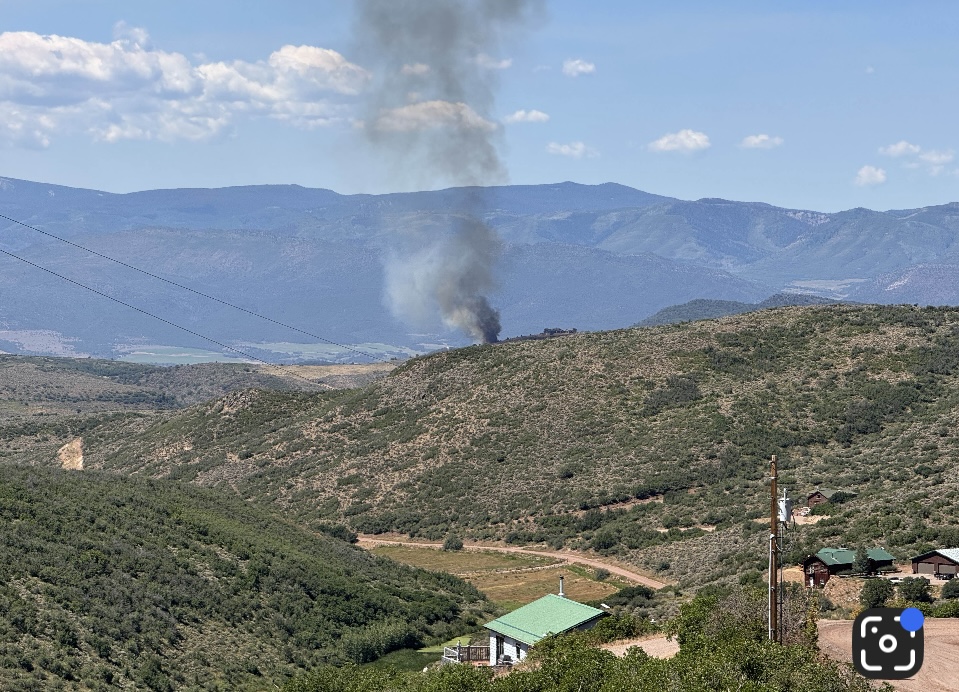
Outlook: Smoke from the Grease fire and the Elk fire in central and southeastern Rio Blanco County, and the Coulter Creek fire in southeastern Garfield County will produce areas of moderate to heavy smoke Sunday evening and Monday morning. The greatest impacts are expected in areas in the immediate vicinity of these fires including mainly rural areas of Rio Blanco County south and southeast of Meeker; and in southeastern portions of Garfield County in the Roaring Fork Valley along Highway 82 near Carbondale and El Jebel; south of Glenwood Springs. Additional smoke impacts may be experienced across the advisory area due to transport of smoke on Sunday and Monday.
PRESS RELEASE 8.3.25, 3:29 pm Carbondale, CO – 11:04 a.m. today, Carbondale & Rural Fire Protection District was dispatched for a report of a wildland fire in the Missouri Heights area.
Upon arrival, firefighters found an active fire burning in grass, pinyon, juniper, and sage moving at a fast rate of spread. Crews immediately began suppression efforts from the ground while air resources were deployed to assist.
The fire is currently estimated at 80 acres. Structures are threatened, though no homes have been lost at this time. The fire is 0% contained, but the rate of spread has slowed due to coordinated efforts by ground crews and aerial resources.
Evacuation orders are in effect for residents in the Panorama Subdivision, the Ranch at Coulter Creek, and the area east of County Road 100 to Upper Cattle Creek Road. Impacted residents needing shelter can go to Roaring Fork High School. Roads in the area have been closed to allow firefighters to work safely.
Firefighters from multiple agencies are working together to contain the fire.
Additional updates will be provided as they become available. @carbondalefiredistrict or Carbondale Fire @garcosheriff or garcosheriff
8.3.25, 2:30 pm: UPDATE: The fire is named the Coulter Creek Fire. It is estimated to be 80 acres. facebook: @carbondalefiredistrict or Carbondale Fire
8.3.25, 2:30 pm: ACTUALIZACIÓN DE LAS 23:00: El incendio se denomina Coulter Creek Fire. Se estima que abarca una superficie de 80 acres. facebook: @carbondalefiredistrict or Carbondale Fire
8.3.25, 1 pm: The Ranch at Coulter Creek fire is 35-40 acres. Multiple ground and air resources are on scene.
8.3.25, 1 pm: El Rancho en Coulter Creek fuego es 35-40 acres. Múltiples recursos contra incendios terrestres y aéreos están en la escena.
Carbondale Middle School evacuation center
8.3.25, 12:55 pm – From GARFIELD COUNTY SHERIFF’S OFFICE: Panorama subdivision, residences east of County Road 100 to Upper Cattle Creek, and Ranch at Coulter Creek – due to FIRE, EVACUATE the area IMMEDIATELY. Evacuation center is Roaring Fork High School at 2770 Highway 133, Carbondale.
8.3.25, 12:55 pm – Desde la Oficina del Sheriff del Condado de Garfield: Subdivisión Panorama, residencias al este de la Carretera del Condado 100 hacia Upper Cattle Creek, y Ranch en Coulter Creek: debido al incendio, se debe evacuar la zona inmediatamente. El centro de evacuación es la Escuela Secundaria Roaring Fork, ubicada en la Carretera 133 n.° 2770, Carbondale.
EVACUATE IMMEDIATELY
8.3.25, 12:19 pm – From GARFIELD COUNTY SHERIFF’S OFFICE: From GARFIELD COUNTY SHERIFF’S OFFICE: Panorama subdivision, residences east of County Road 100 to Upper Cattle Creek, and Ranch at Coulter Creek – due to FIRE, EVACUATE the area IMMEDIATELY. facebook: @garcosheriff or garcosheriff
EVACUAR INMEDIATAMENTE
8.3.25, 12:19 pm – Desde la OFICINA DEL ALGUACIL DEL CONDADO DE GARFIELD: Desde la OFICINA DEL ALGUACIL DEL CONDADO DE GARFIELD: Subdivisión Panorama, residencias al este de County Road 100 hasta Upper Cattle Creek y Ranch en Coulter Creek: debido al INCENDIO, EVACUE el área INMEDIATAMENTE. @garcosheriff or garcosheriff
Coulter Creek FireCoulter Creek Fire
Carbondale & Rural Fire Protection
8.3.25, 12: 06 pm update: Please avoid the area of County Road 100 – County Road 115 and the Missouri Heights area to allow firefighters to work
Ranch at Coulter Creek fire: facebook: @carbondalefiredistrict or Carbondale Fire
8.3.25, 11:24 am – We are on scene of a wildland fire north of Panorama Drive, below the Ranch at Coulter Creek Subdivision. Air resources are enroute.
Estamos en la escena de un incendio forestal al norte de Panorama Drive, por debajo del Rancho en Coulter Creek Subdivision. Los recursos aéreos están en camino.
Garfield County Emergency Communications Authority
7.27.25, 2:06 am – Highway 13 is open between mile markers 3.2 -10.5 both directions, north of Rifle.
7.27.25, 1:58 am – Highway 13 is closed between mile markers 3.2 – 10.5, both directions, from Highway 325 to mile marker 10.5, north of Rifle, due to an accident.