Garfield County Sheriff’s Office
For the Sleepy Creek Fire near Cottonwood Pass, evacuations are enacted on the Eagle County side. Garfield County is setting READY status zones for resident preparedness. Please prepare, pack your valuables and monitor public information if you live in these areas below. A map will be available shortly.
READY STATUS
READY – possible evacuation in your area. Prepare, monitor and pack your valuables.
- High Aspen Ranch subdivision properties in Garfield County.
- Coulter Creek Road (County Road 121) along the Eagle County line in the East Coulter Creek area.
- County Road 113 (Cattle Creek Road) at Eagle County line in section T6SR87W
- Mesa Creek area roads in Garfield County.
Ready | Set | Go
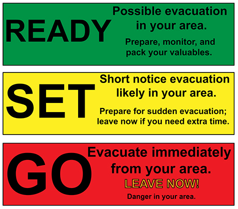
Ready – possible evacuation in your area. Prepare, monitor and pack your valuables.
Set – Short notice evacuation likely in your area. Prepare for sudden evacuation; leave now if you need extra time.
Go – Evacuate immediately from your area. LEAVE NOW! Danger in your area.
Evacuation preparation
Prepare to evacuate quickly and safely in the event of an emergency. Planning and preparation can help you take quick action. Visit our Garfield County Emergency Management evacuation preparedness pages:
Garfield County public safety
GARFIELD COUNTY EMERGENCY COMMUNICATIONS AUTHORITY
REGISTER for alerts – garco911.com | Reachwell mobile app
GARFIELD COUNTY EMERGENCY MANAGEMENT
SUBSCRIBE for incident updates | website
GARFIELD COUNTY SHERIFF’S OFFICE
website | facebook: @GarcoSheriff
______________________________
Oficina del Sheriff del Condado de Garfield
Debido al incendio de Sleepy Creek cerca de Cottonwood Pass, se han decretado evacuaciones en el condado de Eagle.
El condado de Garfield ha establecido zonas de alerta para la preparación de los residentes. Si vive en alguna de las zonas mencionadas, prepárese, empaque sus pertenencias de valor y manténgase informado. Próximamente estará disponible un mapa.
Prepárate
PREPARADOS: posible evacuación en su zona. Prepárense, manténganse alerta y empaquen sus objetos de valor.
- Propiedades en la urbanización High Aspen Ranch en el condado de Garfield.
- Carretera Coulter Creek (Carretera del Condado 121) a lo largo del límite del Condado de Eagle en el área de East Coulter Creek.
- Carretera del condado 113 (Cattle Creek Road) en el límite del condado de Eagle en la sección T6SR87W
- Carreteras de la zona de Mesa Creek en el condado de Garfield.
Durante una evacuación
Prepárese para evacuar rápida y seguramente en caso de emergencia. La planificación y la preparación pueden ayudarle a actuar con rapidez.
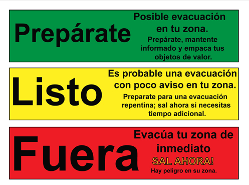
Prepárate: Posible evacuación en tu zona. Prepárate, mantente informado y empaca tus objetos de valor.
Listo: Es probable una evacuación con poco aviso en tu zona. Preparate para una evacuación repentina; sal ahora si necesitas tiempo adicional.
Fuera: Evacúa tu zona de inmediato SAL AHORA! Hay peligro en su zona.
Preparación para la evacuación
Prepárese para evacuar de forma rápida y segura en caso de emergencia. La planificación y la preparación pueden ayudarle a actuar con rapidez. Visite nuestras páginas de preparación para evacuaciones de la Oficina de Gestión de Emergencias del Condado de Garfield:
Canales de información
Oficina del Sheriff del Condado de Garfield
FACEBOOK – Oficina del Sheriff del Condado de Garfield # facebook.com/GarcoSheriff
Gestión de Emergencias del Condado de Garfield
ACTUALIZACIONES DE INCIDENTES/SUSCRÍBASE – garfieldcounty.net
Autoridad de Comunicaciones de Emergencia del Condado de Garfield
REGÍSTRESE PARA RECIBIR ALERTAS – garco911.com y la aplicación móvil Reachwell