Garfield County Public Health
COMMUNITY NOTICE – Air quality
8.10.25
GARFIELD COUNTY, CO – When smoke is in the air, take precautions to reduce exposure to wildfire smoke.
Employers and outdoor workers operating in areas with high levels of wildfire smoke should frequentlymonitor air quality conditions in their area and take steps to reduce smoke exposure, including relocating or rescheduling work tasks to smoke-free or less smoky areas and taking frequent breaks in smoke-free areas.
Reducing exposure to outdoor workers:
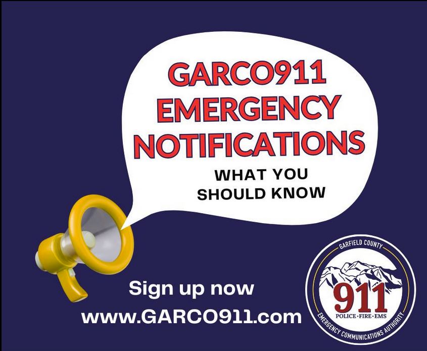
Check the air quality and encourage employees to sign up for emergency alerts.
Smoke levels can change a lot during the day; if possible, wait until air quality is better before being active outdoors.
Keep employees informed about air quality conditions, safety measures, and any changes to work plans.
Limit physical activity
Take it easier when smoke is in the air to reduce how much smoke is inhaled. When indoors, take steps to keep indoor air cool and clean. Encourage breaks and provide access to clean air spaces.
Choose a mask that will help protect from smoke.
It is important to know that cloth masks will not protect from wildfire smoke. N95 masks can provide protection from wildfire smoke. Consult your physician if you are uncertain about which type of mask is right for you or your work environment.
Reschedule outdoor work tasks if possible.
Reschedule outdoor work tasks and activities to a time when air quality improves. If outdoor tasks and activities cannot be rescheduled and must be conducted when air quality is poor, it is recommended that individuals reduce smoke inhalation by:
- Limiting the time spent outdoors by only performing essential activities.
- Taking frequent breaks indoors in places where the air is clean, especially during periods with high outdoor levels of wildfire smoke.
- If you must work outdoors, wear an N95 mask.
Note: Some areas may have regulations to reduce smoke exposure for outdoor workers.
Monitor symptoms
Wildfire smoke can make you sick. Breathing in smoke can affect you right away, causing coughing, trouble breathing, wheezing, asthma attacks, stinging eyes and other symptoms.
Garfield County Public Health information is provided online on the Public Health website.
Protección para los trabajadores al aire libre del humo de incendios forestales
Orientación para empleadores y trabajadores al aire libre
COMUNICADO DE PRENSA
8.10.25
CONDADO DE GARFIELD, CO- Cuando haya humo en el aire, tome precauciones para reducir la exposición al humo de incendios forestales.
Los empleadores y trabajadores al aire libre que operan en zonas con altos niveles de humo de incendios forestales deben monitorear con frecuencia la calidad del aire en su área y tomar medidas para reducir la exposición al humo, incluyendo la reubicación o reprogramación de las tareas laborales en zonas libres de humo o con menos humo, y tomar descansos frecuentes en dichas zonas.
Reducir la exposición de los trabajadores al aire libre:
Revise la calidad del aire y anime a los empleados a registrarse para recibir alertas de emergencia.
Los niveles de humo pueden variar mucho durante el día; si es posible, espere a que la calidad del aire mejore antes de realizar actividades al aire libre. Mantenga a los empleados informados sobre las condiciones de la calidad del aire, las medidas de seguridad y cualquier cambio en los planes de trabajo.
Limite la actividad física
Reduzca la exposición cuando haya humo en el aire para reducir la cantidad de humo que inhala. En interiores, tome medidas para mantener el aire fresco y limpio. Fomente los descansos y proporcione acceso a espacios con aire limpio.
Elija un cubrebocas que le ayude a protegerse del humo.
Es importante saber que los cubrebocas de tela no protegen del humo de los incendios forestales. Los cubrebocas N95 sí pueden brindar protección contra el humo de los incendios forestales. Consulte a su médico si no está seguro de qué tipo de cubrebocas es adecuado para usted o su entorno laboral.
Si es posible, reprograme las tareas y actividades laborales al aire libre por un tiempo en lo que la calidad del aire mejore. Si las tareas y actividades al aire libre no se pueden reprogramar y deben realizarse cuando la calidad del aire es mala, se recomienda reducir la inhalación de humo:
• Limite el tiempo que se pasa al aire libre, realizando únicamente actividades esenciales.
• Tome descansos frecuentes en interiores donde el aire sea limpio, especialmente durante períodos con altos niveles de humo de incendios forestales.
• Si debe trabajar al aire libre, use un cubrebocas N95.
Note: Algunas zonas pueden tener regulaciones para reducir la exposición al humo de los trabajadores al aire libre.
Vigile los síntomas
El humo de los incendios forestales puede causar enfermedades. Inhalar humo puede afectarle de inmediato, causando tos, dificultad para respirar, sibilancias, ataques de asma, escozor en los ojos y otros síntomas.
La información de Salud Pública del Condado de Garfield se proporciona en línea en el sitio web de Salud Pública.