Garfield County Emergency Communications Authority
6.18.26, 7:37 a.m. – Road open: I-70 is open at mile marker 119 eastbound, No Name exit.
6.18.26, 5:16 a.m. – I-70 is closed at mile marker 119 eastbound, No Name exit, due to an accident.
REGISTER for emergency alerts at garco911.com
SUBSCRIBE for emails from this feed - click at upper right
VIEW: Inciweb wildfires | CDOT routes | NOAA storms | CAIC avalanches
Garfield County | Accessibility
6.18.26, 7:37 a.m. – Road open: I-70 is open at mile marker 119 eastbound, No Name exit.
6.18.26, 5:16 a.m. – I-70 is closed at mile marker 119 eastbound, No Name exit, due to an accident.
Avisos en Español para todo el Estado (Colorado)
Issued for Mesa and Garfield counties
Issued at 3:01 PM MDT, Thursday, June 11, 2026
Issued by the Colorado Department of Public Health and Environment
Affected Area: Mesa and Garfield counties. Locations include, but are not limited to Grand Junction and Glenwood Springs.
Advisory in Effect: 3:00 PM MDT, Thursday, June 11, 2026 to 10:00 PM MDT, Thursday, June 11, 2026
Public Health Recommendations: Increasing likelihood of respiratory symptoms and breathing discomfort in active children and adults and people with lung disease, such as asthma. Active children and adults, and people with lung disease, such as asthma, should reduce prolonged or heavy outdoor exertion.
Outlook: A weather event known as a stratospheric intrusion is occurring. During these events, ozone from high in the atmosphere is pulled to the ground, resulting in elevated ozone concentrations. Ozone is expected to be Moderate to Unhealthy for Sensitive Groups through late Thursday evening.
For the latest Colorado statewide air quality conditions, forecasts, and advisories, visit: https://www.colorado.gov/airquality/colorado_summary.aspx
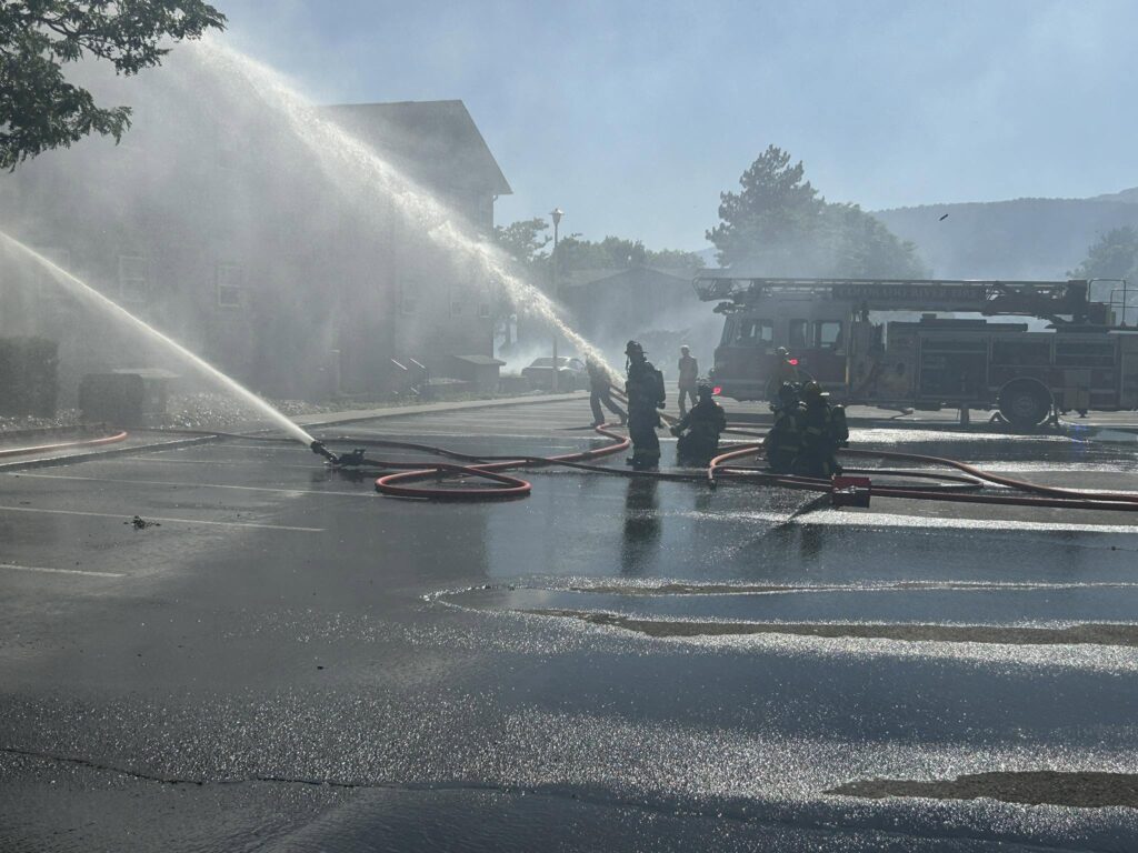
RIFLE, Colo. — June 11, 2026, 11:30 a.m. — Colorado River Fire Rescue (CRFR) continues to work alongside partner agencies following yesterday’s fast-moving structure and wildland fire that originated near Willow Creek Circle and spread along Government Creek to the Rifle Creek Apartments area.
Fire crews remained on scene overnight and continue to address hot spots and conduct mop-up operations. The fire has been mapped at 10 acres and is contained at this time.
Evacuations implemented during the incident have largely been lifted. Two apartment buildings remained under evacuation overnight; however, as of this morning, all residents except those displaced in the fire-damaged apartment building have been allowed to return to their residences.
Colorado River Fire Rescue was assisted by Grand Valley Fire Protection District, Glenwood Springs Fire Department, Carbondale & Rural Fire Protection District, Rifle Police Department, Garfield County Sheriff’s Office, Colorado Department of Transportation (CDOT), Colorado Parks and Wildlife (CPW), BLM, Forest Service, and other cooperating agencies.
The cause of the fire remains under investigation. The Colorado Division of Fire Prevention and Control (DFPC) Fire Investigation Team has been requested to assist in determining the origin and cause of the fire.
As summer fire conditions continue to intensify across western Colorado, Colorado River Fire Rescue reminds residents that Garfield County is currently under Stage 1 Fire Restrictions. Residents and visitors are encouraged to exercise extra caution with any activity that could ignite a fire. Dry vegetation, warm temperatures, and windy conditions can quickly turn a small spark into a rapidly spreading wildfire.
CRFR thanks the public for their cooperation during the evacuations and recognizes the coordinated efforts of all responding agencies throughout the incident.
Leif Sackett
Fire Chief
Colorado River Fire Rescue
Colorado River Fire Rescue
CRFR website | facebook: #ColoradoRiverFireRescue
Lift-Up is at the Rifle Fairgrounds until 1:00 PM today to support families displaced by yesterday’s fire.
If you or someone you know has been affected and is in need of food, supplies, or other essential items, please stop by. Help us spread the word so that everyone who needs assistance can access these resources.
Rifle Fairgrounds
Until 1:00 PM today
Please share with anyone who may have been impacted.
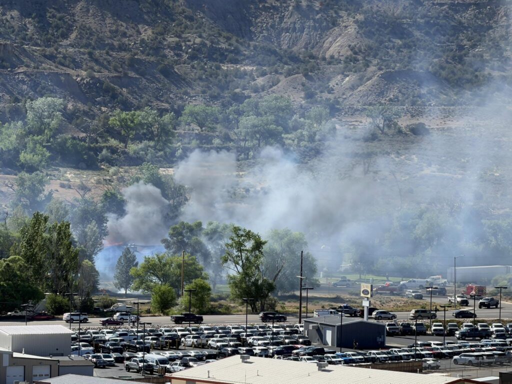
RIFLE, Colo. — June 10, 2026 — Colorado River Fire Rescue (CRFR) responded to a
reported structure fire at approximately 4:01 p.m. today in the 100 block of Willow Creek
Circle in Rifle.
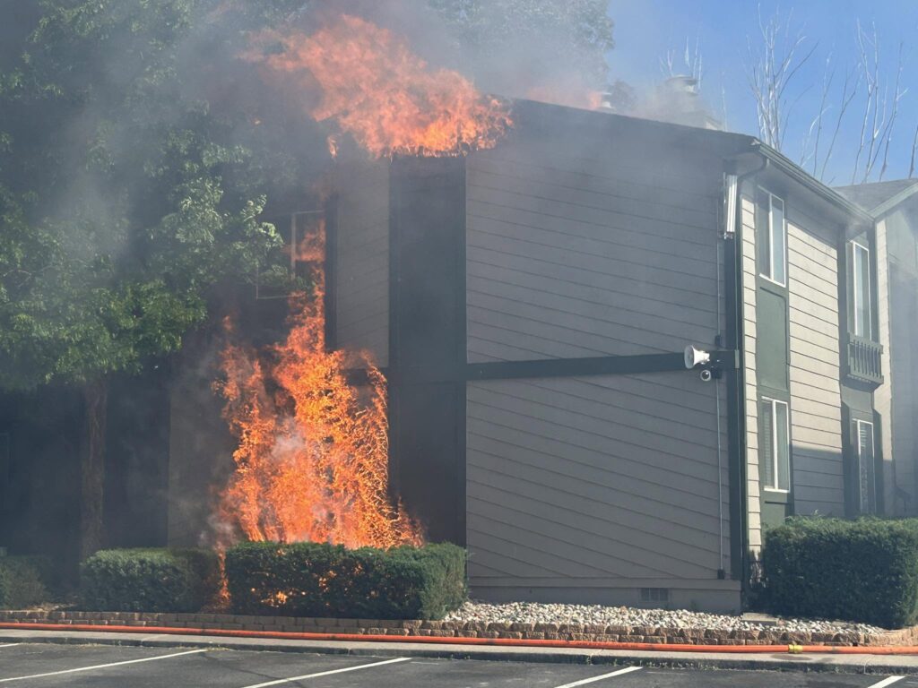
Initial reports indicated a backyard fire threatening a residence. Due to strong winds and
heavy fuel conditions, the fire quickly spread beyond the structure into the wildland area
along Government Creek. The fire continued to advance along the creek corridor toward
the Rifle Creek Apartments near West 30th Street.
Due to high winds, the rapidly evolving incident, evacuations were ordered for residents
along Willow Creek Circle and West 30th Street. Emergency officials have established the
Garfield County Fairgrounds as a temporary evacuation location for displaced residents.
The Red Cross has also been called.
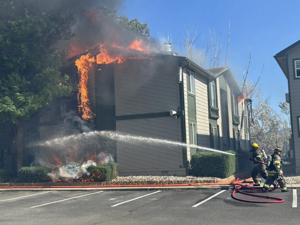
During firefighting operations, the fire spread into the roof of an eight-unit apartment
building at the Rifle Creek Apartments. The building sustained significant damage and is
believed to be a total loss. Firefighters successfully rescued one dog from an apartment
during the incident.
Colorado River Fire Rescue was assisted by numerous partner agencies, including Grand
Valley Fire Protection District, Glenwood Springs Fire Department, Rifle Police
Department, Garfield County Sheriff’s Office, Colorado Department of Transportation
(CDOT), and Colorado Parks and Wildlife (CPW).
Fire crews remain on scene working to contain the fire, extinguish hot spots, and assess
damage.
The cause of the fire remains under investigation.
Colorado River Fire Rescue would like to thank residents for their cooperation during the
evacuations and recognizes the coordinated efforts of all responding agencies.
Additional information will be released as it becomes available.

Leif Sackett
Fire Chief
Colorado River Fire Rescue
Colorado River Fire Rescue
CRFR website | facebook: #ColoradoRiverFireRescue
_______________________________________________________________________
First responders are on the scene of a fire near Highway 13 and W. 26th Street in north Rifle.
West 26th Street is closed at this time.
Please avoid the area at this time and use alternate routes if possible. Emergency personnel are actively working in the area.
We will provide updates as more information becomes available.
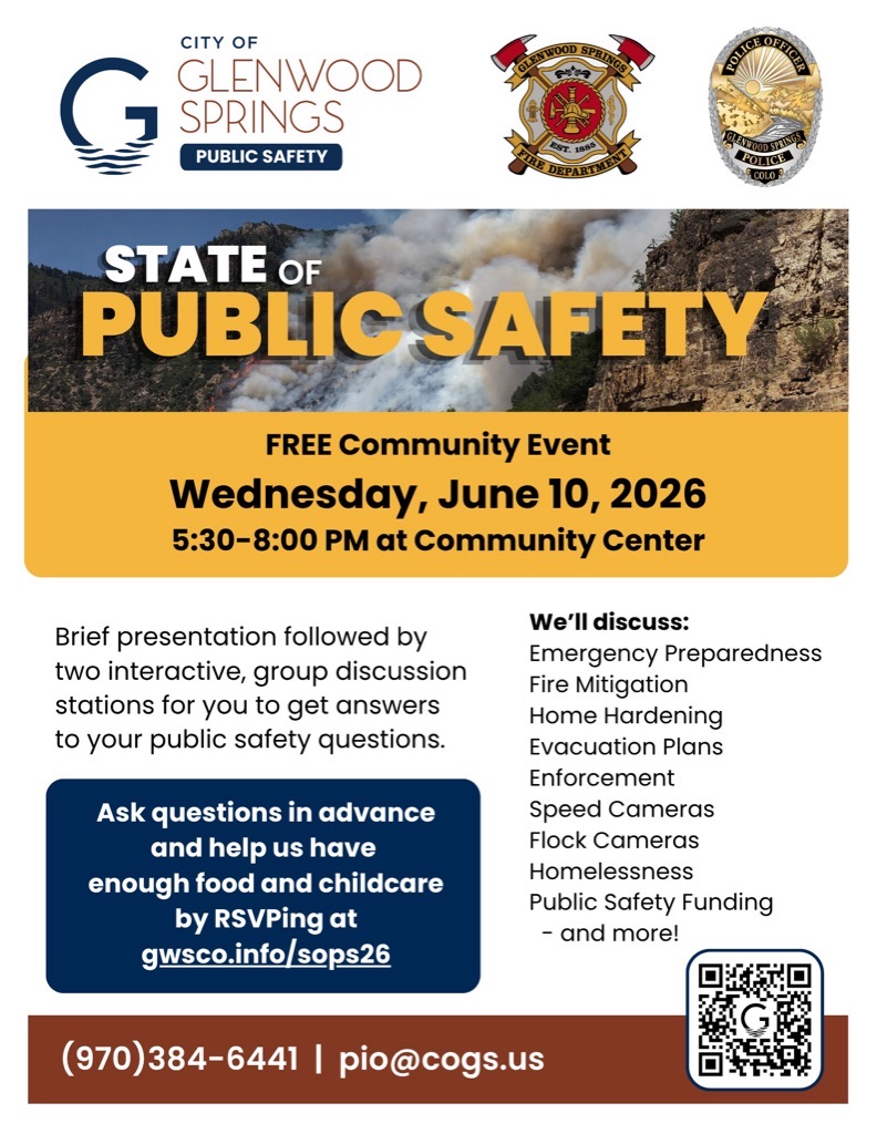
GLENWOOD SPRINGS, Colo. (June 3, 2026) – The City of Glenwood Springs is excited to announce its upcoming State of Public Safety event, taking place Wednesday, June 10, 2026, from 5:30 to 8 p.m. at the Community Center. Doors open at 5:30 p.m. for refreshments and socializing, then event presentations begin at 6 p.m. followed by the question-and-answer sessions.
The event is free and open to all community members, and RSVPs (gwsco.info/sops26) are strongly encouraged to ensure enough food for everyone. Spanish interpretation and childcare will be provided.
The evening sessions will begin at 6 p.m. with brief remarks by Chief of Public Safety Joseph Deras, followed by rotating, interactive Q&A sessions with police and fire department leaders. Residents will take turns asking questions and sharing feedback on topics including:
For anyone who might feel shy about expressing questions or comments in front of a group, there will also be lots of opportunities for written feedback. Questions and comments may also be submitted in advance at gwsco.info/sops26.
###
Contact: Bryana Starbuck, Communications & Engagement Officer, bryana.starbuck@cogs.us
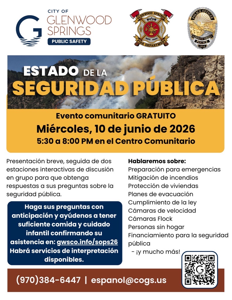
GLENWOOD SPRINGS, Colorado (3 de junio de 2026) – La ciudad de Glenwood Springs se complace en anunciar su evento sobre el estado de la seguridad pública, que tendrá lugar el miércoles 10 de junio de 2026, de 5:30 a 8 p.m., en el Centro Comunitario.
El evento comenzará a las 5:30 p. m. con bocadillos y una oportunidad para convivir. Las presentaciones comenzarán a las 6 p. m., seguidas de una sesión de preguntas y respuestas.
El evento es gratuito y todos los miembros de la comunidad están invitados. Se recomienda confirmar su asistencia para garantizar que haya suficiente comida para todos. Habrá servicio de interpretación en español y cuidado infantil.
Las sesiones de la tarde comenzarán a las 6 p.m. con unas breves palabras del jefe de Seguridad Pública, Joseph Deras, seguidas de sesiones interactivas rotativas de preguntas y respuestas con líderes de los departamentos de policía y bomberos. Los residentes tendrán la oportunidad de hacer preguntas y compartir sus opiniones sobre temas como:
Para quienes se sientan tímidos al expresar sus preguntas o comentarios frente a un grupo, también habrá muchas oportunidades para enviar comentarios por escrito. Las preguntas y comentarios también podrán enviarse con anticipación en gwsco.info/sops26.
###
Contacto: Bryana Starbuck, Oficial de Comunicación y Participación, bryana.starbuck@cogs.us
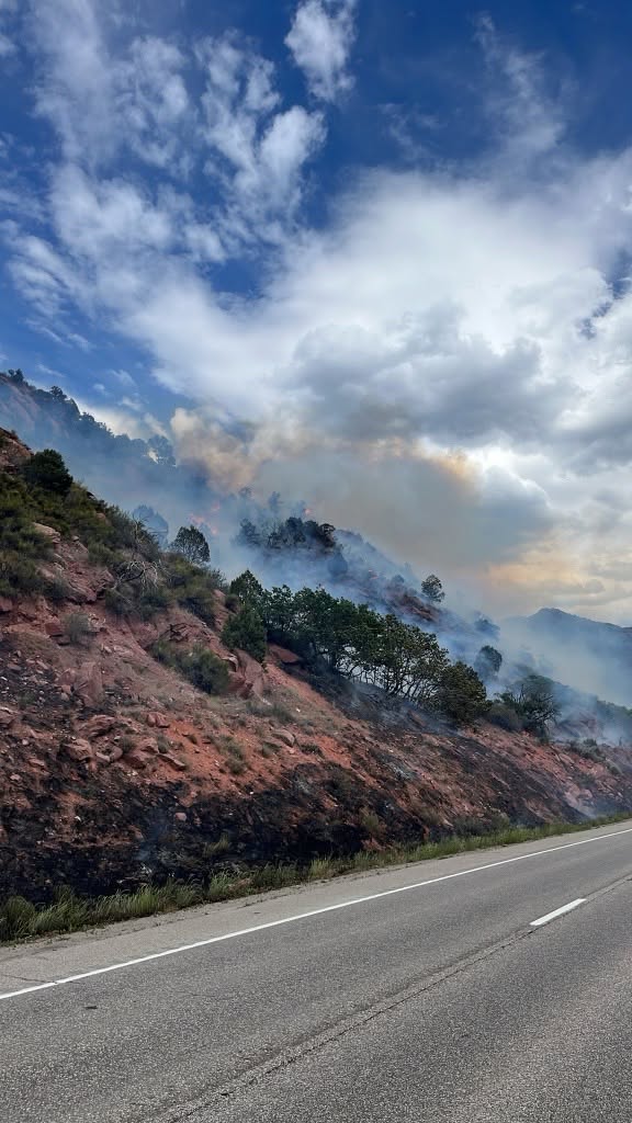
UPDATE – 1:00 pm: Incident Commander Hostetler has declared the fire contained after firefighters successfully secured the established perimeter.
Fuels within the interior of the fire perimeter are expected to continue burning over the next few days, and smoke will remain visible in the area. Firefighters will continue to monitor the fire and address any concerns as needed.
A special thank you to the 24 Diamond Mountain Hotshots from California for their hard work and assistance on the fire this morning. The crew will be released from the incident at 2:00 p.m. today. We appreciate their dedication and support.
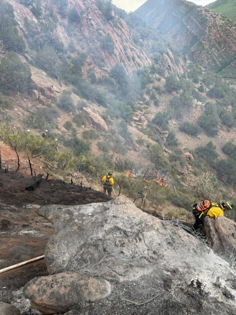
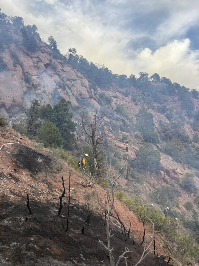
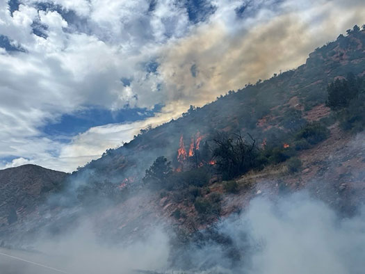
UPDATE – 9:50 am: Firefighters continue to work in steep, rocky terrain to strengthen containment lines and suppress remaining hot spots. Updated mapping has more accurately measured the fire at 4.54 acres.
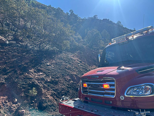
Photos courtesy of Glenwood Springs Fire Department
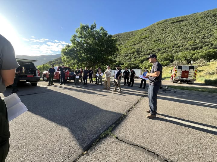
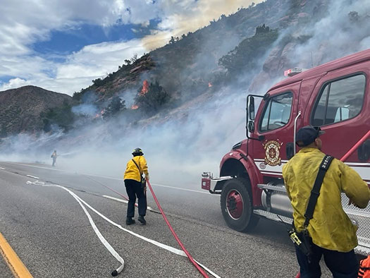
Crews are continuing suppression efforts today. Approximately 30 firefighters and agency partners attended this morning’s briefing. Incident objectives include firefighter and resident safety, achieving full containment, and minimizing additional impacts to I-70.
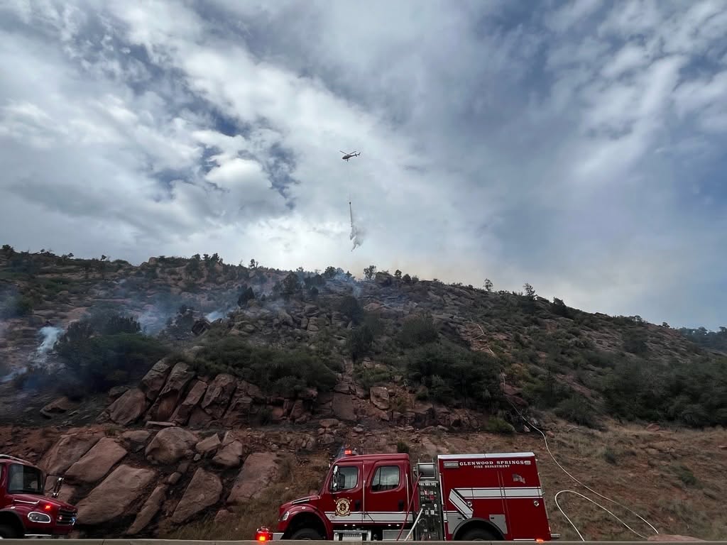
For firefighter safety and access, the slow lane of westbound I-70 in the incident area is expected to remain closed throughout the day. Please use caution and expect delays while traveling through the area.
Thank you for your patience and support.
Glenwood Springs Fire Department
Glenwood Fire website | facebook: #GlenwoodSpringsFireDepartment
The Garfield County Sheriff’s Office, Bureau of Land Management (BLM), and the seven fire districts in Garfield County are implementing Stage 1 Fire Restrictions effective at 1 a.m., Wednesday June 10, 2026. This applies to all of Garfield County.
This decision was made with thoughtful consideration. We look at the data, the potential for significant wildfires and balance it with the impacts to our community. Our concern, with the level of fire danger we are seeing; one spark could quickly spread into a dangerous wildfire threatening lives, property and natural resources.
Fire restrictions are implemented based on specific criteria to include moisture content of vegetation, weather outlooks, human risk factors, recent fire behavior witnessed over the past week and firefighting resource availability. It has been hot, dry, and unseasonably windy. So far this year, we have had several Red Flag Warnings. The National Weather Service is forecasting above average temperatures and dry conditions with no relief from rain anytime soon.
With increasingly dry vegetation, severe drought conditions, and more hot and dry conditions approaching, the danger for human caused wildfires increases even more.
What Stage I Fire Restrictions mean in Garfield County
Penalties
Causing a fire during fire restrictions can be a class 6 felony and can be punishable by fines. Other possible charges range from a Class 2 Felony to a petty offense depending on the value of the damage caused. You may be held financially responsible for damage caused.
Federal lands
The use of fireworks, flares, or other incendiary devices, including exploding targets, are always prohibited on federal lands.
By definition:
A “developed area” is an area, whether within city limits or rural, that is groomed, manicured and or watered, where grasses, brush and trees are regularly attended to by land owner. This includes residential and business areas, improved recreational areas, parks and other common areas.
An “undeveloped area” are lands that are not groomed, manicured, or watered, where grasses, brush and trees have been allowed to grow in a natural environment. This includes green belts that are not landscaped or manicured, open space lands, non-manicured park lands, and other areas where the fire hazard presented by the vegetation is determined by the authority having jurisdiction or designee to be an undue wildland fire hazard.
I-70 eastbound both lanes open at mile marker 109 (Canyon Creek). One lane open westbound I-70 at Glenwood Springs. There is still a westbound closure at Dotsero.
UPDATE – 8:10 p.m. 6/9: I-70 eastbound is now open in both lanes.
I-70 westbound is opening in stages. Traffic at the Glenwood Springs exit, 116, is being released westbound through one open lane on I-70 in the first stage. Once that queue has been lessened, westbound traffic held at the Dotsero exit, 133, will be released.
I-70 both directions is CLOSED – 6:20 p.m. (6/8/2026)
I-70 remains closed in both directions from Chacra, Mile Point 109, to Dotsero, MP 133, due to an active fire. There is no estimated time for opening. Commuters are encouraged to use the norther detour route.
Westbound travelers:
> Take the Wolcott Exit, 159, north on CO 131, to US 40. Stay on US 40 past Craig, then take CO 13 southbound back to I-70 at Rifle.
Eastbound travelers:
> Take the Rifle Exit north on CO 13 to US 40. Take US 40 through Craig to CO 131. Take CO 131 south to Wolcott and back onto I-70.
For further updates, check COtrip.org or the COtrip Planner App.
UPDATE 7:30 pm – The aircraft has been released for the evening. Both eastbound lanes are expected to reopen shortly, along with one westbound lane.
UPDATE 6:42 pm – I-70 is expected to remain closed for an undetermined amount of time. We greatly appreciate everyone’s patience and understanding as crews continue their work.
With back-to-back Red Flag days and challenging wind conditions, we are especially grateful to have air support assisting with fire suppression efforts. The safety of our community and responders remains the top priority, and we will continue to provide updates as more information becomes available.
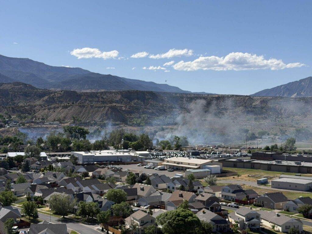
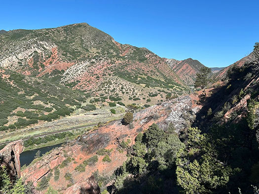
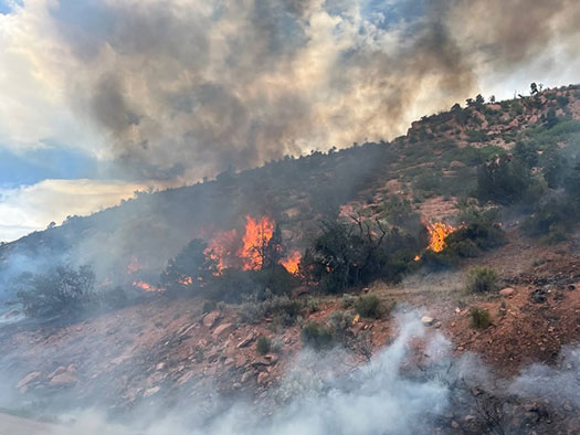
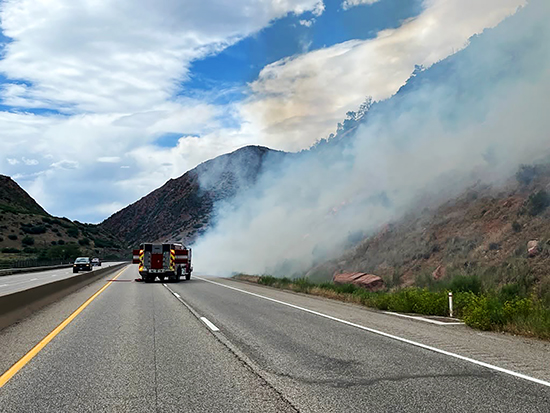
June 9, 2026, 4:40 p.m. – The fire size has been re-estimated at 8 – 10 acres in size.
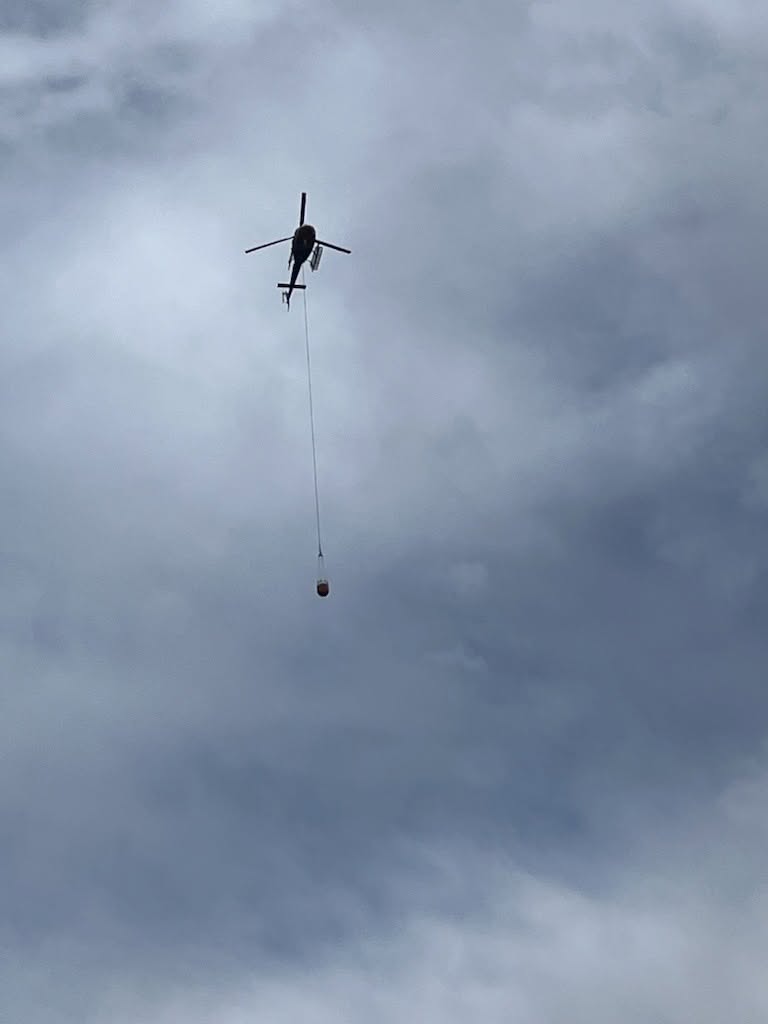
Approximately 44 firefighters are working to stop fire growth in steep and rocky terrain. Due to high winds in the area, fixed wing aircraft are unable to operate at this time.
Upper Colorado River Interagency Fire Management Unit, Colorado Division of Fire Prevention and Control, Colorado River Fire Rescue, Garfield County Emergency Communications Authority, Garfield County Sheriff’s Office – Colorado, Colorado Department of Transportation are responding to this incident in mutual aid.
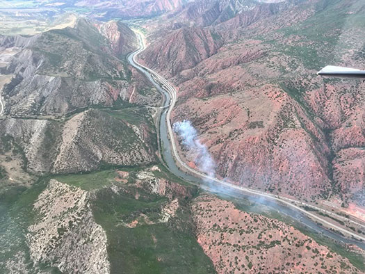
June 9, 2026, 4:07 p.m. – This fire has been named the Paradise Fire and is estimated at 20 acres. Two helicopters and two fixed-wing aircraft are en route to assist with suppression efforts. Aircraft will be refilling bucket drops from the Colorado River. I-70 will remain closed at this time.
_____________________________
ACTUALIZACIÓN 4:40 p. m.
El tamaño del incendio ha sido reestimado entre 8 y 10 acres.
Aproximadamente 44 bomberos trabajan para detener el crecimiento del fuego en un terreno empinado y rocoso. Debido a los fuertes vientos en la zona, las aeronaves no pueden operar en este momento.
Las siguientes agencias están respondiendo a este incidente en un esfuerzo conjunto de ayuda mutua:
Upper Colorado River Interagency Fire Management Unit
Colorado Division of Fire Prevention and Control
Colorado River Fire Rescue
Garfield County Emergency Communications Authority
Garfield County Sheriff’s Office
Colorado Department of Transportation
Todas estas entidades colaboran en las labores de respuesta y control del incendio.
_______________________________________________________________________
ACTUALIZACIÓN 4:07 p.m.
Este incendio ha sido nombrado Paradise Fire y se estima que abarca aproximadamente 20 acres.
Dos helicópteros y dos aeronaves están en camino para ayudar en las labores de supresión del incendio. Las aeronaves recargarán agua para las descargas con balde desde el río Colorado.
La I-70 permanecerá cerrada por el momento.
_______________________________________________________________________
ACTUALIZACIÓN: 3:15 p. m. Ambos sentidos de la I-70 están cerrado de la milla 112.
_______________________________________________________________________
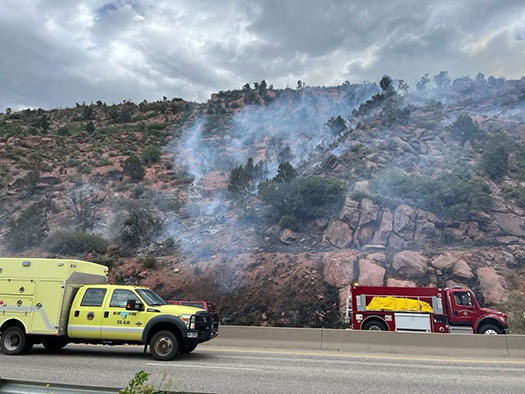
Estamos respondiendo a un incendio junto a la I-70 en dirección oeste, en el marcador de milla 112 en South Canyon. El Departamento de Bomberos y Rescate del Río Colorado está respondiendo en apoyo mutuo. La I-70 en dirección oeste está siendo cerrada en el marcador de milla 112.
Photos courtesy of Glenwood Springs Fire Department
June 9, 2026, 3:15 p.m. – Both directions of I-70 are now closed at the 112 milepost.
June 9, 2026, 3:02 p.m. – Glenwood Springs Fire Department is responding to a brush fire on westbound I-70 at milepost 112 in South Canyon. Colorado River Fire Rescue is responding in mutual aid. I-70 westbound is being closed at milepost 112.
June 9, 2026, 3:06 p.m. – I-70 is closed at mile-marker 112 WB, South Canyon, due to a fire.
Glenwood Springs Fire Department
Glenwood Fire website | facebook: #GlenwoodSpringsFireDepartment