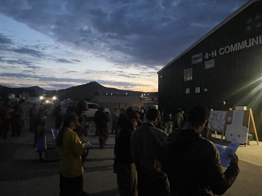
August 15, 2025, 9:11 a.m. – Good Morning from the Elk & Lee fires. Size: Elk Fire – 14,518 acres | Lee Fire – 133,841 acres Containment: Elk Fire – 93% | Lee Fire – 12%
Today on the Elk & Lee fires, crews are focusing on protecting critical values while maintaining safe operations. Highway 13 remains a priority, with crews working to secure the corridor for safe travel. Thunderstorms are possible this afternoon, with erratic winds up to 30 mph and lightning that could increase fire activity and spotting.
Update: August 14, 2025,2:32 pm Road now open please drive safely
Update: August 14, 2025,12:48 pm Road Closed I70 closed Westbound at Exit 87 -West Rifle due to brush fire
———————————————————————————
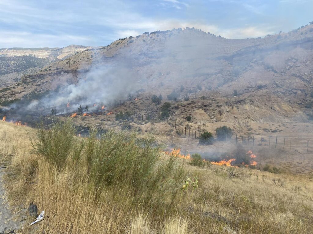
August 14, 2025, 12:04 pm – 81 W I-70 1/4 Acre with moderate rate of spread in Pinyon Juniper. CRFR Engine 41 is on scene with Grand Valley Fire Brush 32 and Tender 31. Resources have been ordered from DeBeque and Interagency. Expect Lane Closures.
El borde sur del incendio Lee ha llegado a la línea del condado de Garfield, lo que provocó los cambios mencionados anteriormente en el estado de evacuación.
Las zonas 81 y 85 están en la parte superior de la meseta de Roan en el paisaje industrial y el área BLM (ya bajo cierre), no son áreas residenciales.
La planificación estratégica de los administradores de incendios incluye múltiples líneas secundarias y de contingencia entre el borde del incendio y el borde sur de la meseta de Roan.
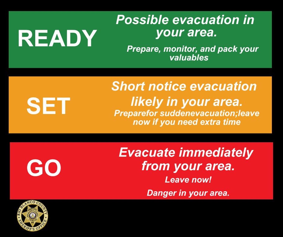
Como recordatorio:
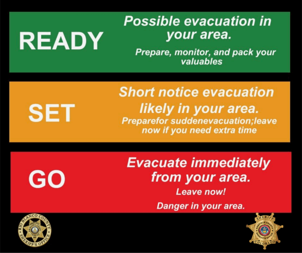
SALIR = Evacuar inmediatamente su zona. Salga ahora: peligro en su zona.
SET = Posible evacuación con poca antelación en su zona. Prepárese para evacuaciones repentinas. Salga ahora si necesita más tiempo.
PREPARADO = Posible evacuación en su zona. Prepare, vigile y empaque sus objetos de valor.
August 12, 2025, 10:05 p.m. – Elk Fire – 14,549 acres | 75% contained Lee Fire – 120,650 acres | 4% contained
Containment on the Lee Fire decreased slightly today due to fire growth and expansion of the perimeter. While we’ve seen significant progress on the Elk Fire, tomorrow brings critical fire weather, meaning conditions will make fire activity more likely and harder to control. Winds will shift and increase from the west/northwest, temperatures will rise into the low 90s, and humidity will drop into the single digits.
These factors could produce tall smoke plumes, erratic surface winds, and an increased risk of spotting, especially near Highway 13.
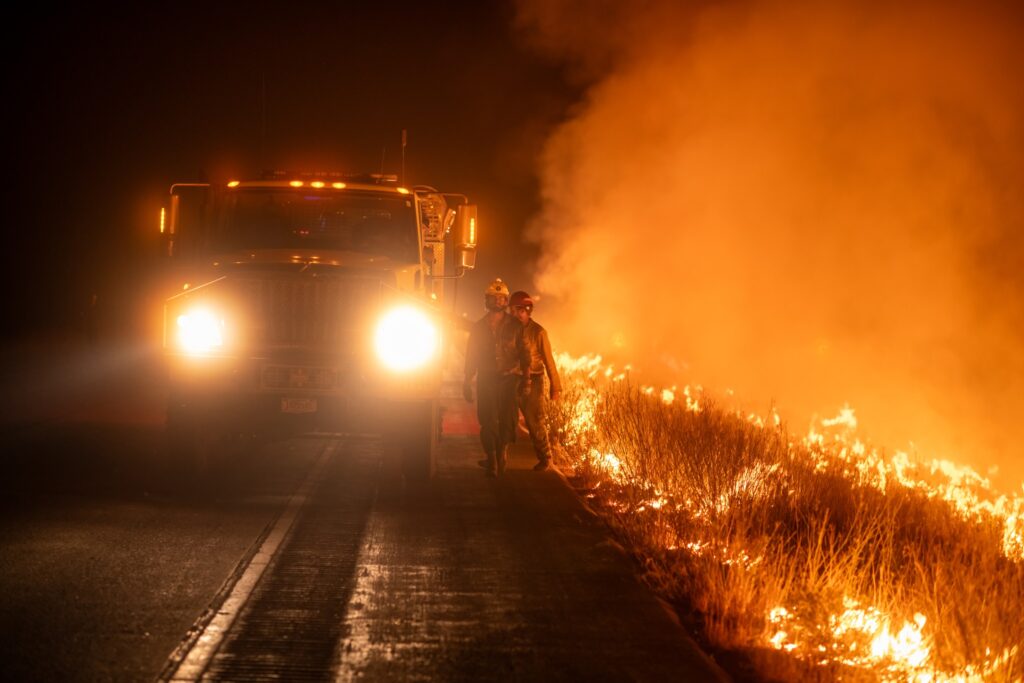
In preparation, crews on both fires will work through the night with heavy equipment to strengthen and secure lines, check for heat, and address interior hot spots identified by infrared flights. Work will also continue on the spot fire south of County Road 5, along with scouting for potential contingency lines near Highway 13.
We’ll share updates as conditions change tomorrow. Please stay alert, ensure you are signed up for emergency alerts, and follow verified information from official sources including this page and at:
August 12, 2025, 6:21 p.m. – Burning operations in the southwest area of the Lee Fire along County Road 5 went well today, and that work is holding as expected.
Crews are also working to contain a spot fire south of County Road 5 that is showing increased activity this afternoon. Aircraft will be in the area, and dozers are building containment line. If needed, firefighters may use offensive firing operations to support their efforts.
GARFIELD COUNTY SHERIFF’S OFFICE – An IPAWS message sent by Moffat County was received by some residents in Garfield County and included information about lifted evacuations. This is NOT related to the Lee Fire and no statuses in Garfield County have changed.
Current status by zone is as follows: Zone 70-GO Zones 71/80/81-SET Zones 72/73-READY
You will receive another message if your zone status is changed.
Rocky Mountain Area Complex Incident Management Team 3
August 9, 2025, 1:51 p.m. – Zone 70 is the first zone in Garfield County to move to red status or GO NOW. The Lee Fire is moving southwest from Highway 13. The best route out is to move south on County Road 253 (Piceance Creek Road) to Highway 13 and proceed down to Rifle, local traffic will be let through this closed route.
9 de agosto de 2025, 1:51 p.m. – La zona 70 es la primera zona en el condado de Garfield en pasar al estado rojo o SALIR AHORA. El incendio de Lee se está moviendo hacia el suroeste desde la autopista 13. La mejor ruta de salida es moverse hacia el sur por County Road 253 (Piceance Creek Road) hasta la autopista 13 y continuar hasta Rifle, el tráfico local podrá pasar por esta ruta cerrada.
GCSO: Evacuate livestock to Parachute Rodeo Grounds
Garfield County Sheriff’s Office
August 9, 2025 – If evacuations are ordered, the Parachute Rodeo Grounds (100 La Plata Circle) can hold livestock. Plan your transportation now. Bring feed, water and medications and have halters and leads ready. We hope this won’t be needed, but being prepared helps keep people and animals safe.
GCSO: Evacuar el ganado a Parachute Rodeo Grounds
9 de agosto de 2025 – Si se ordenan evacuaciones, el Parachute Rodeo Grounds (100 La Plata Circle) puede albergar ganado. Planifique su transporte ahora. Lleve alimento, agua y medicamentos, y tenga listos cabestros y correas. Esperamos que esto no sea necesario, pero estar preparados ayuda a mantener a las personas y a los animales a salvo.
Size: Elk Fire: 14,502 acres | Lee Fire: 88,755 Containment: Elk Fire: 8% | Lee Fire: 0% Total Personnel: 1,245 Cause: Lightning Resources: 13 Aircraft | 62 Engines | 21 Hand Crews | 13 Heavy Equipment Important Notes: All updates related to the Elk and Lee Fires will be posted at: https://www.facebook.com/elkleefire/.
Road closures and evacuation notices for Rio Blanco County will still be posted on the Rio Blanco Sheriff Facebook Page at https://www.facebook.com/RioBlancoCountySheriffsOffice.
Evacuation information for Garfield County will be posted on the Garfield County Sheriff’s Facebook page at https://www.facebook.com/GarcoSheriff.
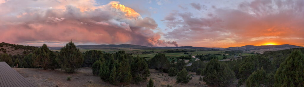
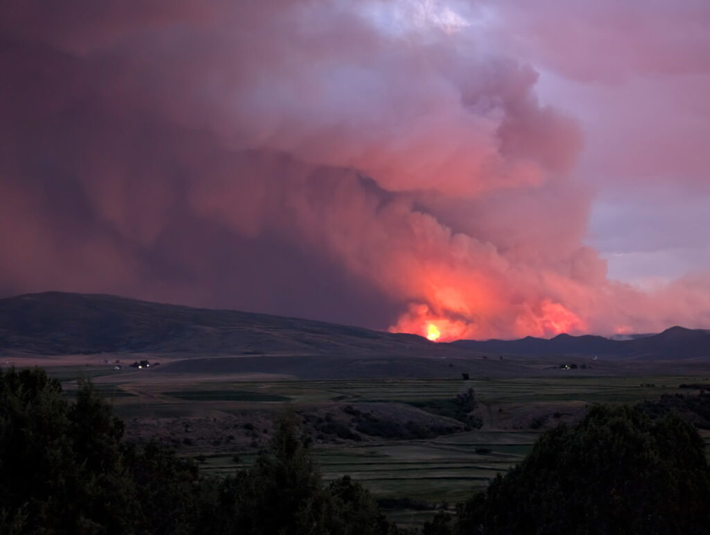
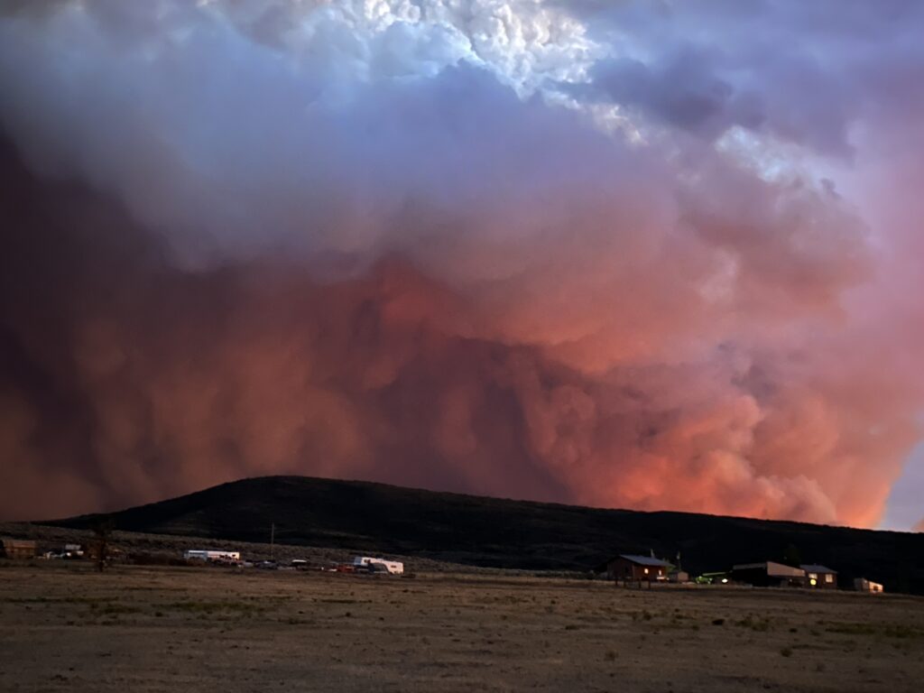
Yesterday: Lee Fire – Pyrocumulus clouds developed as a result of extreme fire behavior induced by high winds and extremely dry vegetation. It moved rapidly to the southeast, resulting in some spotting across CR 5. The fire did not cross into Garfield County however, the increase in activity initiated pre-evacuations in Garfield County. Aerial resources were utilized in the morning until increased winds in the early afternoon impacted the accuracy of water drops and eventually grounded the aircraft. Fire resources worked through the night to protect structures along CR 5. Firefighters conducted point protection around structures utilizing engines and dozers through the night.
Elk Fire: Smoke from the Lee Fire shaded the Elk Fire and reduced fire behavior allowing firefighters to further reinforce firelines. Structure protection resources continued monitoring and reinforcing around structures through the night.
Current Situation: Lee Fire – Firefighter and aerial resources are focusing on the spotting that occurred across CR 5 to contain the spots and keep the fire from spreading toward Hwy 13 and into Garfield County. Fire resources will continue structure protection around homes and other values at risk. Firefighters are patrolling and mopping up hot spots along the perimeter on the Hogback ridge.
Elk Fire: Firefighters will continue patrol and mop up containment lines to keep the fire from further spread. Structure protection resources will remain in place around residences and other values at risk. Weather & Fire Behavior: A Red Flag Warning is in effect from 11:00 a.m. – 8:00 p.m. Temperatures will range in the low to mid-80’s. Humidity’s will fall in the low teens. Winds will shift to the north/northeast mid-morning until early evening. These weather conditions along with the dry fuels are conducive to extreme fire behavior.
Evacuations and closures: Go to the Rio Branco County Sheriff’s Office Facebook page – https://www.facebook.com/RioBlancoCountySheriffsOffice – for accurate up-to-date information on all evacuations and road closures. To sign up for emergency alerts at: https://rioblancoalerts.genasys.com/portal/en.
For Garfield County go to: https://www.garfieldcounty.net/. White River National Forest closure information at: https://www.fs.usda.gov/r02/whiteriver/alerts. BLM White River Field Office closures information at: https://www.blm.gov/announcement/blm-colorado-issues-emergency-closure-public-lands-rio-blanco-county. Air Quality: Current air quality for your area can be found at fire.airnow.gov.
Elk and Lee Fire Information: Phone: 970-341-8665; Email: 2025.elkrbx@firenet.gov Facebook: www.facebook.com/elkleefire Iniciweb Lee Fire: https://inciweb.wildfire.gov/incident-information/cowrd-lee-fire Inciweb Elk Fire: https://inciweb.wildfire.gov/incident-information/cowrd-elk-rbx-fire
New zones moved to SET status
8.9.25, 10:01 am – Zones 70 and 71: Due to the Lee Fire, you are in SET status. Prepare for sudden evacuation orders issued by Garfield County Sheriff’s Office. You will receive another message if you are updated to GO status. Check your zone on this map.
8.9.25, 6:58 a.m. – New EVACUATION STATUS in Garfield County: Zones 80 and 81 are now in SET status. This is to the south of the fire in the northern edge of Garfield County. BE READY to evacuate with short notice from these zones. Prepare now.
8.9.25, 8:17 a.m. – The Lee Fire is producing smoke that is affecting air quality in Garfield County. Visit Air Now to understand if it’s safe to be active outdoors. Be smoke ready and know what steps you can take to protect yourself. If possible, have backup plans to avoid outdoor activities when smoke is thick, and know how to keep your indoor air clean.
Garfield County Emergency Communications Authority
8.9.25, 6:01 a.m. – The Lee and Elk fires in the Meeker area are producing quite a bit of smoke in the valleys of Garfield County due to winds blowing to the south/southwest. There are NO NEW FIRES in GarCo at this time. Please do not call dispatch regarding this smoky haze or strong smell. Some areas of the county are also experiencing falling ash from these same fires.
For updates and information regarding the Lee and Elk fires, please follow the Elk and Lee Fire Information page.
Garfield County Sheriff’s Office and Incident Management Team for the Elk and Lee Fires
8.8.25, 9:30 p.m. – Winds are shifting to move the Meeker area Lee Fire to the southwest toward Highway 13 in southern Rio Blanco County. The Lee Fire is expected to near the Garfield County side overnight or early tomorrow.
Fire officials are alerting Rio Blanco and Garfield County residents to prepare in Ready Set Go modes.
Residents in the area identified as zone 70 should move into Set status for short notice evacuation likely in your area, and zone 71 should move into Ready status to prepare for possible evacuation in your area.
Winds have been steadily moving toward the east southeast direction, and while fire behavior is expected to decrease overnight, the Lee Fire may shift southward.