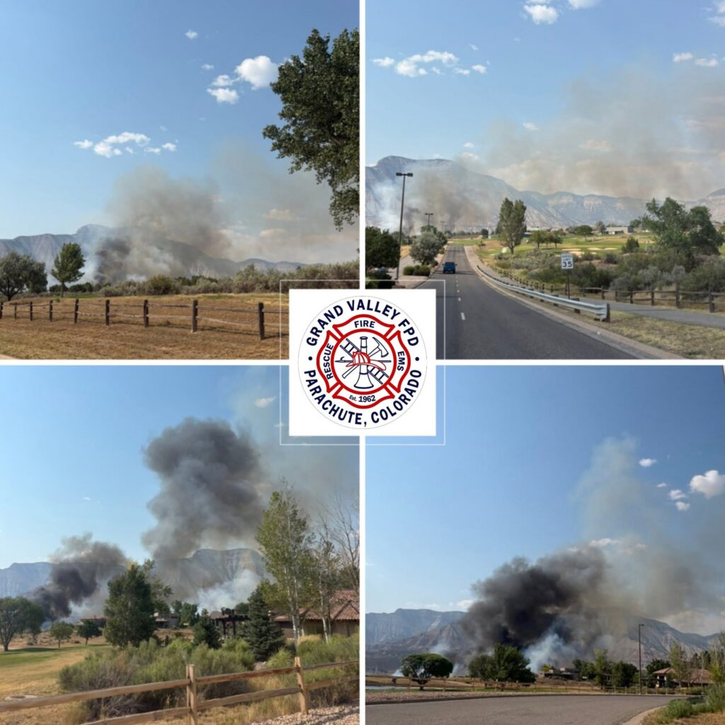
CRFR: morning update on Dry Creek Fire

Colorado River Fire Rescue

June 25, 2026, 9:11 a.m. – Thanks to firefighters’ efforts yesterday, the fire remains at 316 acres.

Overnight moisture provides favorable conditions for firefighter suppression efforts. Today, crews will focus on securing the fire perimeter and extinguishing hot spots on the interior area of the fire perimeter. Smoke dispersal forecasts improved smoke dispersal this afternoon.

Resources assigned include three Type 2 hand crews, one suppression module, 11 fire engines, two water tenders, and one aircraft available if needed.

For the latest evacuation information, visit Garfield County’s evacuation map: https://bit.ly/drycreekfire. Firefighters remain active throughout the incident area, and increased fire apparatus traffic is expected. Please avoid the area if possible.

Burn area of the Dry Creek Fire.

Smoke column from the Dry Creek Fire,

Team morning briefing for the Dry Creek Fire.

Emergency services respond to the Dry Creek Fire by natural gas facilities.

Emergency services respond to the Dry Creek Fire by natural gas facilities.

Emergency services respond to the Dry Creek Fire.

Burn area of the Dry Creek Fire.

Burn area of the Dry Creek Fire.

Emergency services respond to the Dry Creek Fire.

Emergency services respond to the Dry Creek Fire by natural gas facilities.

Burn area of Dry Creek Fire.

Emergency services respond to the Dry Creek Fire by natural gas facilities.

Information channels

Garfield County Sheriff’s Office
FACEBOOK – Garfield County Sheriff’s Office #facebook.com/GarcoSheriff
Garfield County Emergency Management
INCIDENT UPDATES/SUBSCRIBE – garfieldcounty.net
Garfield County Emergency Communications Authority
REGISTER FOR ALERTS – garco911.com and Reachwell mobile app

Colorado River Fire Rescue
CRFR website | facebook: #ColoradoRiverFireRescue

CRFR: morning update on Dry Creek Fire

GCSO: Dry Creek Fire evacuation status

Garfield County Sheriff’s Office

Garfield County is utilizing its Ready, Set, Go evacuation status for the Dry Creek Fire near Rifle. Evacuations are in place around Grass Mesa (Go) and Set status is in place for the area near Hunter Mesa. 

Evacuation map

The evacuation map link is https://bit.ly/drycreekfire.

GO 

GO – Evacuate immediately from your area. LEAVE NOW! Danger in your area.

GO status is in place east of Grass Mesa, along the ridge line east of Grass Mesa Road, including Gage Road and County Road 319 to the east. 

Nobody should access this area at this time.

SET

SET – Short notice evacuation likely in your area. Prepare for sudden evacuation; leave now if you need extra time.

SET status is in place for the area near Hunter Mesa and now Grass Mesa.

The area east of the fire around Hunter Mesa is in SET status. This includes the junction of County Road 315 and Brandon Way to the northeast to a half mile south of County Road 333 and County Road 315 to the southeast. The southern boundary is a half mile north of County Road 322 (Shaeffer). The northern boundary heads straight west at the Brandon Way and County Road 315 junction.

SET status is also now in place for Grass Mesa, inlcuding Grass Mesa Road, south from the intersection with County Road 319, including Sunset Lane, Rodeo Drive, Coyote Trail, Arrowhead Trail, and roads north to Mustang Mesa Trail, including Cedar Breaks Road, Quicksilver Way, and Quick Silver Court.  

During an evacuation

Prepare to evacuate quickly and safely in the event of an emergency. Planning and preparation can help you take quick action.

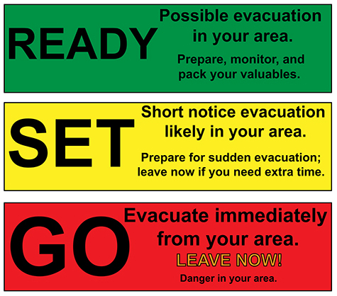
Ready Set Go

Ready – possible evacuation in your area. Prepare, monitor and pack your valuables.
Set – Short notice evacuation likely in your area. Prepare for sudden evacuation; leave now if you need extra time.
Go – Evacuate immediately from your area. LEAVE NOW! Danger in your area.

Information channels

Garfield County Sheriff’s Office
FACEBOOK – Garfield County Sheriff’s Office #facebook.com/GarcoSheriff
Garfield County Emergency Management
INCIDENT UPDATES/SUBSCRIBE – garfieldcounty.net
Garfield County Emergency Communications Authority
REGISTER FOR ALERTS – garco911.com and Reachwell mobile app

Colorado River Fire Rescue
CRFR website | facebook: #ColoradoRiverFireRescue

______________________________

Oficina del Sheriff del Condado de Garfield

Estado de evacuaciĂłn por el incendio de Dry Creek El condado de Garfield ha activado su protocolo de evacuaciĂłn “Preparados, Listos, ¡Adelante!” para el incendio de Dry Creek cerca de Rifle. Se han ordenado evacuaciones en los alrededores de Grass Mesa (¡Adelante!) y se ha activado el protocolo “Listos, Listos, ¡Adelante!” para la zona cercana a Hunter Mesa.

Mapa de evacuaciĂłn

El enlace al mapa de evacuaciĂłn es https://bit.ly/drycreekfire.

FUERA

EvacĂşa tu zona de inmediato SAL AHORA! Hay peligro en su zona.

Grass Mesa para el incendio de Dry Creek cerca de Rifle

Se ha habilitado la vĂ­a pĂşblica al este de Grass Mesa, a lo largo de la cresta al este de Grass Mesa Rd, incluyendo Gage Rd y County Road 319 al este.

Nadie deberĂ­a acceder a esta zona en este momento.

LISTO

Es probable una evacuaciĂłn con poco aviso en tu zona. Preparate para una evacuaciĂłn repentina; sal ahora si necesitas tiempo adicional.

Alerta: Es probable que se produzca una evacuación con poca antelación en su zona. Prepárese para una evacuación repentina; salga ahora si necesita más tiempo.

Se ha establecido un estado de alerta para el área cercana a Hunter Mesa y Grass Mesa.

El área al este del incendio, alrededor de Hunter Mesa, se encuentra bajo estado de incendio controlado. Esto incluye desde el cruce de la carretera del condado 315 y Brandon Way al noreste hasta medio kilómetro al sur del cruce de la carretera del condado 333 y la carretera del condado 315 al sureste. El límite sur se ubica medio kilómetro al norte de la carretera del condado 322 (Shaeffer). El límite norte se extiende directamente hacia el oeste en el cruce de Brandon Way y la carretera del condado 315.

También se ha establecido el estado de seguridad para Grass Mesa, incluyendo Grass Mesa Road, al sur de la intersección con County Road 319, incluyendo Sunset Lane, Rodeo Drive, Coyote Trail, Arrowhead Trail y las carreteras al norte hasta Mustang Mesa Trail, incluyendo Cedar Breaks Road, Quicksilver Way y Quick Silver Court.

El lĂ­mite occidental es la zona Go en Grass Mesa.

Durante una evacuaciĂłn

Prepárese para evacuar rápida y seguramente en caso de emergencia. La planificación y la preparación pueden ayudarle a actuar con rapidez.
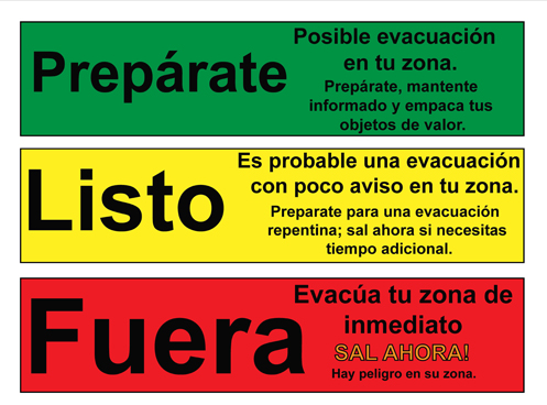
Preparate, listo, fuera graphic

Prepárate: Posible evacuación en tu zona. Prepárate, mantente informado y empaca tus objetos de valor.
Listo: Es probable una evacuaciĂłn con poco aviso en tu zona. Preparate para una evacuaciĂłn repentina; sal ahora si necesitas tiempo adicional.
Fuera: EvacĂşa tu zona de inmediato SAL AHORA! Hay peligro en su zona.

Canales de informaciĂłn

Oficina del Sheriff del Condado de Garfield
FACEBOOK – Oficina del Sheriff del Condado de Garfield # facebook.com/GarcoSheriff
GestiĂłn de Emergencias del Condado de Garfield
ACTUALIZACIONES DE INCIDENTES/SUSCRÍBASE – garfieldcounty.net
Autoridad de Comunicaciones de Emergencia del Condado de Garfield
REGÍSTRESE PARA RECIBIR ALERTAS – garco911.com y la aplicación móvil Reachwell

Rescate de Incendios del RĂ­o Colorado
Sitio web de CRFR  | facebook: # ColoradoRiverFireRescue

GCSO: Dry Creek Fire evacuation status

GCSO: Stage 2 Fire Restrictions begin Friday, June 26

Garfield County Sheriff’s Office

June 23, 2026 – Garfield County, CO, the Garfield County Sheriff’s Office, Bureau of Land Management (BLM) lands, the U.S. Forest Service in Garfield County, and the seven Fire Districts in Garfield County are implementing Stage 2 Fire Restrictions effective at 1 a.m. Friday June 26, 2026. This applies to all of Garfield County.

This decision was made with thoughtful consideration. We look at the data as well as the potential for significant wildfires and balance it with the impacts to our community. The current active wildfires in Colorado have already stretched our available resources and effected our ability to respond as necessary.

Fire restrictions are implemented based on specific criteria to including moisture content of vegetation, weather outlooks, human risk factors, and firefighting resource availability.

What Stage 2 Fire Restrictions mean in Garfield County

  • A) Use of fireworks – Not permitted
  • B) Burn permits (General) – No burn permits will be issued. All previously issued burn permits are cancelled.
  • C) Recreational fires- No recreational fires
  • D) Cooking fires – Use caution and keep attended. Cooking devices must be clean (including gas cylinder) and in proper working order.
  1. Gas Grills – No permit required.
  2. Charcoal and other solid fuel grills and cookers – No permit required in developed areas only.
  3. In undeveloped areas, a permit from the local fire department may be required.
  • E) Smoking – Open smoking allowed in developed areas.
  1. In undeveloped areas, allowed only in an enclosed vehicle or building.
  • F) Welding and spark-emitting cutting (hot work) – Developed area: Use extreme caution and take preventative measures as necessary.
  1. Undeveloped area: Industrial use only. A permit from the local fire department may be required. Must be in a cleared area at least 10 feet in diameter with a designated lookout. Must have Class A fire extinguishing capabilities readily available.
  • G) Operating of internal combustion engine-powered equipment, such as chainsaws, hand-held tools, or generators without a spark-arresting device is prohibited. If described equipment does have a spark arresting device, you must have Class A fire extinguishing capabilities readily available, and round-point shovel (36? length minimum) shall be readily available for use.
  • H) Other internal combustion engine-powered equipment, such as tractors and mowers: Operate with extreme caution paying special attention in areas subject to extreme conditions that may be susceptible to ignition (dry weeds and grasses, etc.).
  • I) Use of explosives, explosive targets and steel or tracer bullets – not permitted.
  • J) Use of firearms – steel jacket/core bullets (armor piercing) and tracer bullets are expressly prohibited. It is the responsibility of each independent range to ensure safe fire conditions at all times the range is in use. This includes: mitigating fuels that may potentially catch fire; monitoring downrange conditions/impacts; maintaining the ability to access and rapidly extinguish fires; notifying the local fire department immediately in the event of a fire of any size. Keeping a usable fire-extinguishing application method on hand is strongly recommended.
  1. If shooting at an unattended range – including those on public and private property – the responsibility for ensuring safe fire conditions falls on the independent shooter.

By definition:
A “developed area” is an area, whether within city limits or rural, that is groomed, manicured and or watered, where grasses, brush and trees are regularly attended to by landowner. This includes residential and business areas, improved recreational areas, parks and other common areas.

“Undeveloped areas” are lands that are not groomed, manicured, or watered; where grasses, brush and trees have been allowed to grow in a natural environment. This includes green belts that are not landscaped or manicured, open space lands, non-manicured parklands, and other areas where the fire hazard presented by the vegetation is determined by the authority having jurisdiction or designee to be an undue wildland fire hazard.

The mission of the Garfield County Sheriff’s Office is to provide solutions for the people through professional, ethical and compassionate conduct.

GCSO: Stage 2 Fire Restrictions begin Friday, June 26

CRFR: Structure/wildfire response south of Rifle – evacuations in progress for Gage Road

Colorado River Fire Rescue

June 23, 2026, 4:34 p.m. – The UCR Type 3 Incident Management Team has been ordered. ICP Location is being established. Additional air resources have been ordered including, two large air tankers, two helicopters, and Air Attack.

June 23, 2026, 4:27 p.m. – The fire has jumped County Road 319. Additional mutual aid resources have been requested by Incident Command.

June 23, 2026, 4 p.m. – Evacuation updates:

  • Grass Mesa Rd. north of Gage Rd.
  • Sunset Lane
  • Gage Rd north of mile marker 1
  • ALL evacuees can go to the Garfield County Fairgrounds in Rifle.
  • Additional air tankers and two IA crews have been ordered.

June 23, 2026, 3:27 p.m. – Crews are responding to a reported structure fire south of Rifle on Gage Road. Additional structures and gas infrastructures are threatened. Air resources, mutual aid, and interagency resources have also been ordered.

Please avoid the area and give emergency responders room to work. Use caution if traveling nearby and watch for emergency vehicles.

More information will be shared as it becomes available.

Colorado River Fire Rescue
CRFR website | facebook: #ColoradoRiverFireRescue

Garfield County Sheriff’s Office

Aerial view of the Dry Creek Fire.

Dry Creek Fire from a gravel road.

June 23, 2026, 3:48 p.m. – Fire in the Grass Mesa area on Gage Road in Rifle. Some neighborhoods are being evacuated. Please stay clear of the area.

CRFR: Structure/wildfire response south of Rifle – evacuations in progress for Gage Road

Stage 1 Fire Restrictions begin June 10, 2026

Above average temperatures and dry conditions with no relief from rain in the forecast

GCSO PRESS RELEASE
June 9, 2026

The Garfield County Sheriff’s Office, Bureau of Land Management (BLM), and the seven fire districts in Garfield County are implementing Stage 1 Fire Restrictions effective at 1 a.m., Wednesday June 10, 2026. This applies to all of Garfield County.

This decision was made with thoughtful consideration. We look at the data, the potential for significant wildfires and balance it with the impacts to our community. Our concern, with the level of fire danger we are seeing; one spark could quickly spread into a dangerous wildfire threatening lives, property and natural resources.

Fire restrictions are implemented based on specific criteria to include moisture content of vegetation, weather outlooks, human risk factors, recent fire behavior witnessed over the past week and firefighting resource availability. It has been hot, dry, and unseasonably windy. So far this year, we have had several Red Flag Warnings. The National Weather Service is forecasting above average temperatures and dry conditions with no relief from rain anytime soon.

With increasingly dry vegetation, severe drought conditions, and more hot and dry conditions approaching, the danger for human caused wildfires increases even more.

What Stage I Fire Restrictions mean in Garfield County

  • Fireworks are not allowed under Stage I Fire Restrictions. Professional fireworks shows may be allowed through the permitting process.
  • All burn permits are postponed/Canceled until further notice.
  • Campfires are only allowed within designated fire grates in Developed Areas (i.e. a permanent in-ground containment structure or store-bought fire pit) A temporary fire pan and rock campfire rings will not be acceptable.
  • No fires of any type including charcoal in undeveloped areas.
  • No smoking except within a designated area, enclosed vehicle or building, a developed area or in an area free of combustibles.
  • No use of fireworks or explosive materials, including “exploding” targets or bullets and tracer rounds.
  • Exercise common sense and industry safety practice when welding or operation of an acetylene or other similar torch with open flame always cleared safe area of vegetation and combustibles.

Penalties
Causing a fire during fire restrictions can be a class 6 felony and can be punishable by fines. Other possible charges range from a Class 2 Felony to a petty offense depending on the value of the damage caused. You may be held financially responsible for damage caused.

Federal lands
The use of fireworks, flares, or other incendiary devices, including exploding targets, are always prohibited on federal lands.

By definition:
A “developed area” is an area, whether within city limits or rural, that is groomed, manicured and or watered, where grasses, brush and trees are regularly attended to by land owner. This includes residential and business areas, improved recreational areas, parks and other common areas.

An “undeveloped area” are lands that are not groomed, manicured, or watered, where grasses, brush and trees have been allowed to grow in a natural environment. This includes green belts that are not landscaped or manicured, open space lands, non-manicured park lands, and other areas where the fire hazard presented by the vegetation is determined by the authority having jurisdiction or designee to be an undue wildland fire hazard.

Stage 1 Fire Restrictions begin June 10, 2026

CRFR/GCSO: train vs. truck collision east of Rifle

Colorado River Fire Rescue | Garfield County Sheriff’s Office

May 6, 2026, 4:14 p.m. – At approximately 9:39 a.m. this morning, Colorado River Fire Rescue (CRFR) was dispatched to a reported collision involving a passenger train and a tanker truck between Silt and Rifle, Colorado.

CRFR responded with two engines, two ambulances, and a Battalion Chief. Upon arrival, crews found a passenger train involved in a collision with a tanker truck carrying hot asphalt tar. The collision resulted in the derailment of the train.

The driver of the tanker truck sustained minor to moderate injuries and was transported by ambulance for medical evaluation. No additional patients required transport.

CRFR personnel assisted approximately 310 passengers and train staff members from the train to waiting buses for transportation to their final destination.

Multiple agencies assisted with the incident response, including the Garfield County Sheriff’s Office, Colorado State Patrol, Colorado Department of Transportation, New Castle Police Department, and Union Pacific personnel.

The incident remains under investigation by the appropriate authorities.

Leif Sackett
Fire Chief
Colorado River Fire Rescue

Local fire officials next to the train that collided with a tanker truck near Rifle on May 6.

Photo of the tanker truck that collided with a train near Rifle on May 6.

Photo of the train that collided with a tanker truck near Rifle on May 6.

Photo of the tanker truck that collided with a train near Rifle on May 6.

Photo of the train that collided with a tanker truck near Rifle on May 6.

May 6, 2026, 10:19 a.m. – At 9:38 a.m., emergency crews were paged to a train vs. tanker truck collision at a railroad crossing just east of Rifle on Highway 6&24.

Highway 6&24 is currently closed. Injuries are unknown at this time.

Please avoid the area and allow first responders to work safely. More details will be released as they become available.

Follow Colorado River Fire Rescue (CRFR Facebook) and Garfield County Sheriff’s Office Facebook for more information.

May 6, 2026, 10:04 a.m. – Highway 6 in Rifle is closed near Mile Pond Road (near Casey Concrete) due to a crash involving a train and a tanker truck.

Emergency crews are on scene and working the incident. At this time only minor injuries have been reported.

Please use an alternate route while responders safely manage the scene.

Colorado Department of Transportation

May 6, 2026, 10:33 p.m. – U.S. 6 is closed in both directions between Mile Pond Road and Peterson Lane (near Rifle) at Mile Point 94.5. Road closed expect delays due to a crash involving a train. See map for detour(s).

Comment: Please plan alternate routes, extended closure likely.

A train vs. tanker truck collision at a railroad crossing just east of Rifle.

A train vs. tanker truck collision at a railroad crossing just east of Rifle.

A train vs. tanker truck collision at a railroad crossing just east of Rifle.

A train vs. tanker truck collision at a railroad crossing just east of Rifle.

CRFR/GCSO: train vs. truck collision east of Rifle

Garco911: I-70 westbound reopened at West Glenwood

Garfield County Emergency Communications Authority

1.15.25, 12:17 a.m. – I-70 is open at mile marker 114 westbound, West Glenwood.

Garfield County Sheriff’s Office

1.14.26, 9:25 p.m. – There is no estimated time to reopen and the closure is expected to be extended in length.

Garfield County Emergency Communications Authority

1.14.26, 7:29 p.m. – I-70 is closed at mile marker 114 westbound, West Glenwood, due to an accident.

Garco911: I-70 westbound reopened at West Glenwood

Garco911 & GCSO: I-70 closed in Glenwood Canyon

Garfield County Sheriff’s Office

1.13.26, 4:40 a.m. – CORRECTION: I-70 is closed eastbound at the mile marker 119, No Name Rest Area.

1.13.26, 4:27 a.m. – UPDATE: Eastbound is now closed at the mile marker 116, Glenwood Springs. It is also closed westbound at the Gypsum exit in Eagle County.

Garfield County Emergency Communications Authority

1.13.26, 4:19 a.m. – I-70 is closed at mile marker 125 eastbound, Hanging Lake, due to police activity.

Garco911 & GCSO: I-70 closed in Glenwood Canyon

Derby Fire: Evacuations lifted by the Garfield County Sheriff’s Office

Garfield County Sheriff’s Office

The two Garfield County ready (green) evacuation zones for the Derby Fire are lifted due to successful suppression efforts and moist weather conditions.

Zone 265 and zone 268 in Garfield County west and south of the Derby Fire containment lines are no longer in any evacuation preparation status. Stage 1 fire restrictions still apply in these areas, including in the White River National Forest.

As fire complexity decreases and assigned resources are scaled appropriately, crews remain on scene to continue suppression efforts with a goal of full containment. While fire suppression efforts continue, smoke is expected to remain visible throughout the season, likely until snowfall arrives.

Evacuation zones for the Lee Fire were lifted August 26, so no further zone statuses are in effect in Garfield County on either the Lee or Derby fires.

The Garfield County Sheriff’s Office offers a sincere thank you to our residents for preparing to evacuate and monitoring fire spread and official status updates in the Ready-Set-Go model during both the Lee and Derby fires. Garfield County Emergency Management will continue using this model for future evacuation updates to alert the community during incident management.

Garfield County Sheriff’s Office and staff, Garfield County Emergency Management, and Garfield County leadership and staff extend our deepest gratitude to Rocky Mountain Complex Incident Management Team 3, the Northern Rockies Complex Incident Management Teams 1 and 3, FDNY Incident Management Team, and the incoming Derby Fire Type 3 incident management team for their excellence in fire strategy and suppression on behalf of public safety for our residents.

INTERACTIVE EVACUATION MAP: https://arcg.is/S0u4G

READY – SET – GO evacuation status chart

Ready - Set - Go graphic for evacuation status

GO (red) = Evacuate immediately from your area. Leave now – danger in your area.

SET (yellow) = Short notice evacuation likely in your area. Prepare for sudden evacuations. Leave now if you need extra time.

READY (green) = Possible evacuation in your area. Prepare, monitor, and pack your valuables.

Garfield County: 
REGISTER FOR ALERTS – garco911.com
FACEBOOK – facebook.com/garcosheriff
INCIDENT UPDATES/SUBSCRIBE – garfieldcounty.net
Derby Fire information page: https://www.facebook.com/DerbyFire/

Derby Fire: Evacuations lifted by the Garfield County Sheriff’s Office

Stage 1 fire restrictions in Garfield County

Garfield County Sheriff and seven fire districts, Upper Colorado River District BLM, White River National Forest

GARFIELD COUNTY SHERIFF’S OFFICE NEWS RELEASE: STAGE I FIRE RESTRICTIONS TO REPLACE STAGE II FIRE RESTRICTIONS IN GARFIELD COUNTY

Garfield County fire restrictions
BLM – Upper Colorado River District fire restrictions
White River National Forest fire restrictions

After careful consideration, Garfield County, CO, the Garfield County Sheriff, Upper Colorado River District Bureau of Land Management, the White River National Forest and the seven fire districts in Garfield County moved from stage II fire restrictions to stage I fire restrictions effective 12:01 a.m. MST Friday September 5, 2025. The fire danger is still high but less than it was for the past several weeks when we were under stage II restrictions.

Fire restrictions are implemented based on specific criteria to include moisture content of vegetation, weather outlooks, human risk factors and firefighting resource availability

WHAT STAGE I FIRE RESTRICTIONS MEAN IN GARFIELD COUNTY

  • Fireworks are not allowed under stage I fire restrictions. Professional fireworks shows may be allowed through the permitting process.
  • All burn permits are postponed/canceled until further notice.
  • Campfires are only allowed within designated fire grates in developed areas (i.e. a permanent in-ground containment structure or store bought fire pit). A temporary fire pan and rock campfire rings will are not acceptable.
  • No fires of any type including charcoal in undeveloped areas.
  • No smoking except within a designated area, enclosed vehicle or building, a developed area or in an area free of combustibles.
  • No use of fireworks or explosive materials, including “exploding” targets or bullets and tracer rounds.
  • Exercise common sense and industry safety practice when welding or operation of an acetylene or other similar torch with open flame always cleared safe area of vegetation and combustibles.

Penalties

Causing a fire during fire restrictions can be a class 6 felony and can be punishable by fines. Other possible charges range from a class 2 felony to a petty offense, depending on the value of the damage caused. You may be held financially responsible for damage caused.

federal lands

The use of fireworks, flares, or other incendiary devices, including exploding targets, are always prohibited on federal lands.

By definition:

A “developed area” is an area, whether within city limits or rural, that is groomed, manicured and or watered, where grasses, brush and trees are regularly attended to by land owner. This includes residential and business areas, improved recreational areas, parks and other common areas.

“Undeveloped areas” are lands that are not groomed, manicured, or watered, where grasses, brush and trees have been allowed to grow in a natural environment. This includes green belts that are not landscaped or manicured, open space lands, non-manicured park lands, and other areas where the fire hazard presented by the vegetation is determined by the authority having jurisdiction or designee to be an undue wildland fire hazard.

Additional information will be released as it becomes available.

Stage 1 fire restrictions in Garfield County