Derby Fire: Evacuations lifted by the Garfield County Sheriff’s Office

Garfield County Sheriff’s Office

The two Garfield County ready (green) evacuation zones for the Derby Fire are lifted due to successful suppression efforts and moist weather conditions.

Zone 265 and zone 268 in Garfield County west and south of the Derby Fire containment lines are no longer in any evacuation preparation status. Stage 1 fire restrictions still apply in these areas, including in the White River National Forest.

As fire complexity decreases and assigned resources are scaled appropriately, crews remain on scene to continue suppression efforts with a goal of full containment. While fire suppression efforts continue, smoke is expected to remain visible throughout the season, likely until snowfall arrives.

Evacuation zones for the Lee Fire were lifted August 26, so no further zone statuses are in effect in Garfield County on either the Lee or Derby fires.

The Garfield County Sheriff’s Office offers a sincere thank you to our residents for preparing to evacuate and monitoring fire spread and official status updates in the Ready-Set-Go model during both the Lee and Derby fires. Garfield County Emergency Management will continue using this model for future evacuation updates to alert the community during incident management.

Garfield County Sheriff’s Office and staff, Garfield County Emergency Management, and Garfield County leadership and staff extend our deepest gratitude to Rocky Mountain Complex Incident Management Team 3, the Northern Rockies Complex Incident Management Teams 1 and 3, FDNY Incident Management Team, and the incoming Derby Fire Type 3 incident management team for their excellence in fire strategy and suppression on behalf of public safety for our residents.

INTERACTIVE EVACUATION MAP: https://arcg.is/S0u4G

READY – SET – GO evacuation status chart

Ready - Set - Go graphic for evacuation status

GO (red) = Evacuate immediately from your area. Leave now – danger in your area.

SET (yellow) = Short notice evacuation likely in your area. Prepare for sudden evacuations. Leave now if you need extra time.

READY (green) = Possible evacuation in your area. Prepare, monitor, and pack your valuables.

Garfield County: 
REGISTER FOR ALERTS – garco911.com
FACEBOOK – facebook.com/garcosheriff
INCIDENT UPDATES/SUBSCRIBE – garfieldcounty.net
Derby Fire information page: https://www.facebook.com/DerbyFire/

Derby Fire: Evacuations lifted by the Garfield County Sheriff’s Office

Stage 1 fire restrictions in Garfield County

Garfield County Sheriff and seven fire districts, Upper Colorado River District BLM, White River National Forest

GARFIELD COUNTY SHERIFF’S OFFICE NEWS RELEASE: STAGE I FIRE RESTRICTIONS TO REPLACE STAGE II FIRE RESTRICTIONS IN GARFIELD COUNTY

Garfield County fire restrictions
BLM – Upper Colorado River District fire restrictions
White River National Forest fire restrictions

After careful consideration, Garfield County, CO, the Garfield County Sheriff, Upper Colorado River District Bureau of Land Management, the White River National Forest and the seven fire districts in Garfield County moved from stage II fire restrictions to stage I fire restrictions effective 12:01 a.m. MST Friday September 5, 2025. The fire danger is still high but less than it was for the past several weeks when we were under stage II restrictions.

Fire restrictions are implemented based on specific criteria to include moisture content of vegetation, weather outlooks, human risk factors and firefighting resource availability

WHAT STAGE I FIRE RESTRICTIONS MEAN IN GARFIELD COUNTY

  • Fireworks are not allowed under stage I fire restrictions. Professional fireworks shows may be allowed through the permitting process.
  • All burn permits are postponed/canceled until further notice.
  • Campfires are only allowed within designated fire grates in developed areas (i.e. a permanent in-ground containment structure or store bought fire pit). A temporary fire pan and rock campfire rings will are not acceptable.
  • No fires of any type including charcoal in undeveloped areas.
  • No smoking except within a designated area, enclosed vehicle or building, a developed area or in an area free of combustibles.
  • No use of fireworks or explosive materials, including “exploding†targets or bullets and tracer rounds.
  • Exercise common sense and industry safety practice when welding or operation of an acetylene or other similar torch with open flame always cleared safe area of vegetation and combustibles.

Penalties

Causing a fire during fire restrictions can be a class 6 felony and can be punishable by fines. Other possible charges range from a class 2 felony to a petty offense, depending on the value of the damage caused. You may be held financially responsible for damage caused.

federal lands

The use of fireworks, flares, or other incendiary devices, including exploding targets, are always prohibited on federal lands.

By definition:

A “developed area” is an area, whether within city limits or rural, that is groomed, manicured and or watered, where grasses, brush and trees are regularly attended to by land owner. This includes residential and business areas, improved recreational areas, parks and other common areas.

“Undeveloped areas” are lands that are not groomed, manicured, or watered, where grasses, brush and trees have been allowed to grow in a natural environment. This includes green belts that are not landscaped or manicured, open space lands, non-manicured park lands, and other areas where the fire hazard presented by the vegetation is determined by the authority having jurisdiction or designee to be an undue wildland fire hazard.

Additional information will be released as it becomes available.

Stage 1 fire restrictions in Garfield County

GCSO: Missing juvenile found

Garfield County Sheriff’s Office

Missing juvenile Tristin Delhagen

UPDATE: AS OF 10:30 am – Tristin has been safely located! Thanks for your help.

5’11, 130-140 pounds, blond hair, blue eyes. Last wearing a navy blue jacket with jeans and boots.

Missing juvenile Tristin Delhagen

If you have any information, please call Garfield County Emergency Communications Authority non-emergency number at 970-625-8095 or 911.

GCSO: Missing juvenile found

Derby Fire: Red Dirt Creek, Sweetwater, and Colorado River Roads open tomorrow

Eagle County and Garfield County Sheriff’s Offices

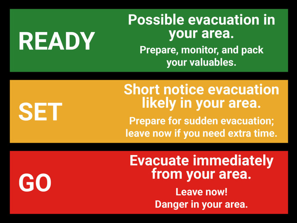
Garfield County zones remain in pre-evac (READY) status

News Release: 8.26.25Eagle/Garfield Counties – Beginning Wednesday, August 27, at 8 a.m., the Eagle County and Garfield County Sheriff’s Offices, in coordination with Derby Fire managers, will begin downgrading evacuation orders for Red Dirt Creek Road, Sweetwater Road, and Colorado River Road in phases throughout the day. After close collaboration with partner agencies and careful monitoring of conditions, these areas will move into pre-evacuation (ready) status. This allows residents to return home, but to still be prepared for risks while fire suppression continues.

“We’re extremely grateful for the work that has been accomplished by the fire crews in protecting our communities from potential devastation. Their hard work and effort are making it possible to return to a more normal pace,†said James Van Beek, Eagle County Sheriff.

Evacuation access will reopen in the following order:

Starting at 8 AM Wednesday:

All road closures will be lifted on Colorado River Road, including the closures near Coffee Pot Road and at Red Dirt Creek Road. Normal traffic will resume in both directions.

Sweetwater Road will remain closed to non-essential traffic, but a phased reentry process will begin

Sweetwater Road Reentry Schedule:

8:00 AM: Forest Service and Bureau of Land Management permit holders may begin accessing Sweetwater Road to transport gear, crews, and animals. Proof of a valid Forest Service or BLM permit will be required at the closure point.

12:00 PM: Residents may begin returning livestock and animals to their properties. An access card, proof of residency, or property ownership will be required at the closure point.

4:00 PM: The full closure on Sweetwater Road will be lifted, and the road will reopen to all traffic.

We understand how stressful and disruptive evacuations can be, and we sincerely thank our community residents for their patience and cooperation. While we are relieved to welcome residents back, it is important to remain alert and prepared.

Fire crews will remain active in the area, and heavy equipment will be positioned to provide structure protection as needed. We ask everyone to exercise extreme caution when traveling. Please yield to first responders at all times and limit non-essential movement to ensure crews have clear access to operate safely. You may find sprinklers, hoses, pumps, or water tanks on your property. Please do not move or drive over these items. If you need assistance with them, contact the Incident Management Team for help.

Recent rainfall has provided much-needed assistance in fire suppression efforts. However, with that rain comes new risks. Emergency managers are now closely monitoring for potential flooding and flash flooding in the burn area and surrounding communities.

We encourage all residents to stay aware of changing conditions, follow guidance from local authorities, and use caution when traveling through the area.

The safety of our community remains our top priority, and we are grateful for the teamwork of our partner agencies, emergency crews, and community members.

On Wednesday, the White River National Forest is reducing its public closure area. For more information, visit www.fs.usda.gov/r02/whiteriver/alerts.

***EN ESPAÑOL***

Comunicado de Noticias: 8.26.25 – Las carreteras Red Dirt Creek, Sweetwater y Colorado River volverán a abrirse el miércoles bajo estado de Preevacuación

Condados de Eagle y Garfield: A partir del Miércoles 27 de Agosto a las 8:00 a. m., las oficinas del alguacil de los condados de Eagle y Garfield, en coordinación con los gestores del incendio Derby, comenzarán a reducir las órdenes de evacuación para las carreteras Red Dirt Creek, Sweetwater y Colorado River por fases a lo largo del día. Tras una estrecha colaboración con las agencias asociadas y un cuidadoso seguimiento de las condiciones, estas zonas pasarán al estado de preevacuación (listo). Esto permite a los residentes regresar a sus hogares, pero sin dejar de estar preparados para los riesgos mientras continúa la supresión del incendio.

“Estamos extremadamente agradecidos por el trabajo realizado por los equipos de bomberos para proteger nuestras comunidades de una posible devastación. Su arduo trabajo y esfuerzo están haciendo posible volver a una vida más normalâ€, dijo James Van Beek, alguacil del Condado de Eagle.

El acceso para la evacuación se reabrirá en el siguiente orden:

A partir de las 8am del Miércoles:

Se levantarán todos los cierres de carreteras en Colorado River Road, incluidos los cierres cerca de la carretera Coffee Pot y en la carretera Red Dirt Creek. Se reanudará el tráfico normal en ambas direcciones.

La carretera Sweetwater permanecerá cerrada al tráfico no esencial, pero se comenzará un proceso de reentrada por fases.

Horario de reingreso a la carretera Sweetwater

8:00 AM: Los titulares de permisos del Servicio Forestal y de la Oficina de Gestión de Tierras pueden comenzar a acceder a la carretera Sweetwater para transportar equipos, personal y animales. Se exigirá la presentación de un permiso válido del Servicio Forestal o de la Oficina de Gestión de Tierras en el punto de cierre.

12:00 PM: Los residentes pueden comenzar a devolver el ganado y los animales a sus propiedades. Se requerirá una tarjeta de acceso, prueba de residencia o propiedad en el punto de cierre.

4:00 PM: Se levantará el cierre total de la carretera Sweetwater y se reabrirá en su totalidad.

Entendemos lo estresantes y disruptivas que pueden ser las evacuaciones, y agradecemos sinceramente a los residentes de nuestra comunidad por su paciencia y cooperación. Aunque nos alivia dar la bienvenida a los residentes, es importante permanecer alerta y preparados.

Los equipos de bomberos permanecerán activos en la zona y habrá maquinaria pesada para proteger las estructuras según sea necesario. Rogamos a todos que tengan extremo cuidado al trasladarse. Ceda el paso a los equipos de rescate en todo momento y limite los desplazamientos no esenciales para garantizar que los equipos tengan acceso libre para operar con seguridad. Es posible que encuentre aspersores, mangueras, bombas o tanques de agua en su propiedad. No mueva ni pase por encima de estos elementos. Si necesita ayuda con ellos, póngase en contacto con el equipo de gestión de incidentes.

Las recientes lluvias han proporcionado una ayuda muy necesaria en las labores de supresión del incendio. Sin embargo, con esas lluvias llegan nuevos riesgos. Los gestores de emergencias están ahora vigilando de cerca la posibilidad de inundaciones y riadas en la zona quemada y las comunidades de los alrededores.

Animamos a todos los residentes a que se mantengan al tanto de los cambios en las condiciones, sigan las instrucciones de las autoridades locales y tengan precaución al viajar por la zona.

La seguridad de nuestra comunidad sigue siendo nuestra máxima prioridad, y agradecemos la colaboración de nuestras agencias asociadas, los equipos de emergencia y los miembros de la comunidad.

El miércoles, el Bosque Nacional White River reducirá su área de cierre al público. Para obtener más información, visite www.fs.usda.gov/r02/whiteriver/alerts.

Derby Fire: Red Dirt Creek, Sweetwater, and Colorado River Roads open tomorrow

Derby Fire: Residents to be granted limited access to Sweetwater Valley and Sheep Creek

Eagle County Sheriff’s Office / Garfield County Sheriff’s Office

Eagle/Garfield Counties– Starting Monday, August 25 at 10 a.m., the Eagle County and Garfield County Sheriff’s Offices, in coordination with Derby Fire managers, will begin transitioning Sweetwater Valley and Sheep Creek from full evacuation to pre-evacuation (SET) status. This change will allow residents to return to their properties while remaining prepared to leave if conditions change. 

We’re grateful to offer limited access so residents can rest in their homes for now. That said, livestock are not to be returned yet, as fire activity could shift and safety remains our top priority. 

“This is not a full repopulation, as the risks are still very high and residents should remain prepared to vacate at any time,†said James Van Beek, Eagle County Sheriff. 

To protect both residents and fire crews, travel within the restricted area must remain extremely limited. If travel is essential, the best window is between 10:00 a.m. and 4:00 p.m. when conditions are safest and least disruptive to emergency operations. 

We are working closely with the school district to ensure continuity for students. School buses will run at their normal times, with pickup and drop-off occurring at regular locations. This is considered essential travel and will be supported throughout the response. 

Please avoid all nonessential movement, as fire activity remains unpredictable and crews need clear access to operate safely. 

Reentry for residents will require verification of residency or property ownership at the closure points on Colorado River Road. Federal Law Enforcement and Sheriff’s Office personnel will facilitate this process and issue authorized passes accordingly. 

Firefighting and structure protection efforts are actively underway, and residents traveling to and from their properties should be aware that fuel reduction and defensible space work may result in noticeable changes to the landscape. Please do not move or drive over any firefighting or water-handling equipment, as crews may need to use it quickly if fire conditions shift. Always yield to fire personnel and vehicles, and know that teams are working diligently to restore full access and help residents return to their homes permanently. 

If you hold a permit issued by the Forest Service or Bureau of Land Management, please coordinate directly with the issuing agency to arrange access to the restricted area. â€œThank you for your cooperation. It will allow us to provide this limited access for evacuated residents and still ensure safety for you and firefighting personnel, “ Sheriff Van Beek said.

Derby Fire official information

FACEBOOK – Derby fire @derbyfire
INCIWEB – Derby Fire
WHITE RIVER NATIONAL FOREST – facebook.com/whiteriverNF @whiteriverNF

_______________

EAGLE COUNTY INFO
DERBY FIRE: EAGLE COUNTY EVACUATION MAP
REGISTER FOR ALERTS – 911 alerts
INCIDENT UPDATES – EC Emergency or Reachwell app
FACEBOOK – facebook.com/eaglecountyso @eaglecountyso

________________

GARFIELD COUNTY INFO
DERBY FIRE: GARFIELD COUNTY INTERACTIVE EVACUATION MAP
REGISTER FOR ALERTS – 911 alerts or Reachwell app
INCIDENT UPDATES / SUBSCRIBE – Garfield County emergency
FACEBOOK – facebook.com/garcosheriff @garcosheriff

Incendio de Derby: Los residentes tendrán acceso limitado a Sweetwater Valley y Sheep Creek

Condados de Eagle y Garfield: a partir del lunes 25 de agosto a las 10 a.m., las Oficinas del Sheriff del condado de Eagle y del condado de Garfield, en coordinación con los administradores del incendio Derby, comenzarán a hacer la transición de Sweetwater Valley y Sheep Creek del estado de evacuación total al estado de pre-evacuación (SET). Este cambio permitirá a los residentes regresar a sus propiedades y permanecer preparados para irse si las condiciones cambian.

Agradecemos poder ofrecer acceso limitado para que los residentes puedan descansar en sus hogares por ahora. Dicho esto, el ganado no debe regresar todavía, ya que la actividad del fuego podría cambiar y la seguridad sigue siendo nuestra principal prioridad.

“Esta no es una repoblación total, ya que los riesgos siguen siendo muy altos y los residentes deben estar preparados para desalojar en cualquier momento â€, dijo James Van Beek, sheriff del Condado de Eagle.

Para proteger tanto a los residentes como a los bomberos, el acceso dentro del área restringida debe permanecer extremadamente limitado. Si desplazarse es esencial, el mejor momento para hacerlo es entre las 10:00 a.m. y las 4:00 p.m., cuando las condiciones son más seguras y menos disruptivas para las operaciones de emergencia.

Estamos trabajando en estrecha colaboración con el distrito escolar para garantizar continuidad para los estudiantes. Los autobuses escolares funcionarán en sus horarios habituales y las recogidas y bajadas se realizarán en los lugares habituales. Este se considera un viaje esencial y contará con apoyo durante toda la respuesta.

Evite todo movimiento que no sea esencial, ya que la actividad del incendio sigue siendo impredecible y los equipos necesitan acceso libre para operar de manera segura.

El reingreso de los residentes requerirá verificación de residencia o propiedad en los puntos de cierre en Colorado River Road. El personal de las fuerzas del orden federales y de la Oficina del Sheriff facilitarán este proceso y emitirán pases autorizados en consecuencia.

Los esfuerzos de extinción de incendios y protección de estructuras están en marcha activamente, y los residentes que viajan hacia y desde sus propiedades deben ser conscientes de que la reducción de combustible y el trabajo de espacio defendible pueden resultar en cambios notables en el paisaje. No mueva ni conduzca sobre ningún equipo contra incendios o de manejo de agua, ya que los equipos podrían necesitar usarlo rápidamente si las condiciones del incendio cambian. Ceda siempre el paso al personal de bomberos y a los vehículos, y sepa que los equipos están trabajando diligentemente para restablecer el acceso total y ayudar a los residentes a regresar a sus hogares de forma permanente.

Si tiene un permiso emitido por el Servicio Forestal o la Oficina de Administración de Tierras, coordine directamente con la agencia emisora para organizar el acceso al área restringida.

“Gracias por su cooperación. Eso nos permitirá brindar este acceso limitado a los residentes evacuados y aún así garantizar su seguridad y la del personal de bomberos“, dijo el Sheriff Van Beek.

Información oficial de Derby Fire

FACEBOOK – Derby Fire @derbyfire 
INCIWEB – Derby Fire 
BOSQUE NACIONAL WHITE RIVER – facebook.com/whiteriverNF @whiteriverNF

_______________

INFORMACIÓN DEL CONDADO DE EAGLE
INCENDIO DE DERBY: MAPA DE EVACUACIÓN DEL CONDADO DE EAGLE
REGÃSTRESE PARA RECIBIR ALERTAS – Alertas del 911 ACTUALIZACIONES DE INCIDENTES – Emergencia EC o aplicación Reachwell FACEBOOK – facebook.com/eaglecountyso @eaglecountyso

________________

INFORMACIÓN DEL CONDADO DE GARFIELD
DERBY FIRE: MAPA DE EVACUACIÓN INTERACTIVO DEL CONDADO DE GARFIELD
REGÃSTRESE PARA RECIBIR ALERTAS: alertas del 911 o aplicación Reachwell
ACTUALIZACIONES DE INCIDENTES / SUSCRÃBASE: emergencia del condado de Garfield
FACEBOOK: facebook.com/garcosheriff @garcosheriff

Derby Fire: Residents to be granted limited access to Sweetwater Valley and Sheep Creek

Lee Fire: Zone downgrades for Garfield County

Garfield County Sheriff’s Office

EVACUATION update from Garfield County Sheriff’s Office:

LEE FIRE

8.22.25, noon: Two zones in Garfield County are downgrading status now due to decreased fire activity and successful suppression efforts.

Zone 80 is in READY (GREEN) West of Highway 13 in north Garfield County
Zone 81 is in READY (GREEN) West and south of Zone 80 in north Garfield County

Lee Fire zones in Garfield County remain in READY (GREEN) status at this time.

INTERACTIVE EVACUATION MAP: http://bit.ly/lee-fire-zones (check your address)

Ready Set Go graphic

As a reminder:

GO = Evacuate immediately from your area. Leave now – danger in your area.

SET = Short notice evacuation likely in your area. Prepare for sudden evacuations. Leave now if you need extra time.

READY = Possible evacuation in your area. Prepare, monitor, and pack your valuables.

Garfield County: REGISTER FOR ALERTS – garco911.com
INCIDENT UPDATES/SUBSCRIBE – garfieldcounty.net
FACEBOOK – facebook.com/garcosheriff
Elk and Lee Fire Information page: https://www.facebook.com/elkleefire

Lee Fire: Zone downgrades for Garfield County

Derby Fire: Leave evacuated areas for safety

Eagle County Sheriff’s Office, Garfield County Sheriff’s Office, Eagle County Emergency Operations Center

August 21, 10:45 a.m. – The Derby Fire grew to more than 2600 acres in the past two days. Winds are moving in a southward direction today, August 21, and outflow winds pushing downward risk fire spread today.

Eagle County: Zone 266-A along the Colorado River Road has been moved to pre-evacuation status. The Colorado River Road remains closed to non-residents and unapproved traffic. Evacuations remain in place for Sweetwater and Red Dirt Creek.

Leave evacuated areas now for your immediate safety.

Evacuations remain in place for zones 327, 330, 266, 264, and 265, including Sweetwater Road and sections of the Colorado River Road from Sweetwater to Red Dirt Creek both in Eagle and Garfield counties. Click on the map to identify the zones: Genasys Protect. 

SWEETWATER, SWEETWATER LAKE AND TO WEST END OF CR 150 – Evacuation in place
COLORADO RIVER ROAD – Evacuation in place
DERBY MESA – Pre-evacuation, prepare to leave, monitor updates
Follow directions from authorities.
For evacuation questions, please call the Eagle County Evacuation information line: 970-328-7400.

Evacuated areas are lawfully closed to public access.  

Eagle County’s evacuation center

Gypsum Recreation Center, 52 Lundgren Blvd, Gypsum, is open from 9 a.m. to 5 p.m. 

Services available at the Evacuation Center include: information sharing, resource connection, showers, restroom facilities and light refreshments. It is located near The Salvation Army Canteen that provides meals for evacuees and first responders.The evacuation center is not accepting or in need of any donations at this time. Monetary donations can be made to the Salvation Army. 

Parking at the Eagle Sports Complex for evacuees
The Eagle Sports Complex parking lot is available for evacuees to park and camp, providing easy access to their livestock being sheltered at the fairgrounds.

Move animals to safety

For anyone seeking support for livestock and animal evacuations, please contact Connie Melzer of CSU Extension, 970-471-8043. The Eagle County Fairgrounds are closed to public use at this time. 

For support with smaller animals, dogs and cats, please call the Eagle County Animal Services #970-471-3763.

Smoke impacts

If visibility is less than 5 miles, smoke has reached levels that are unhealthy. Stay indoors and consider creating a clean air space or leaving the area temporarily.

The fire is now managed by the Northern Rockies Complex Incident Management 3 team. 

Derby Fire email
2025.derby@firenet.gov 

Derby Fire phone
For Derby Fire questions, please contact: 970-355-3283.

Derby Fire official information:

FACEBOOK – Derby fire @derbyfire
INCIWEB – Derby Fire
WHITE RIVER NATIONAL FOREST – facebook.com/whiteriverNF @whiteriverNF

_______________

EAGLE COUNTY INFO
REGISTER FOR ALERTS – 911 alerts
INCIDENT UPDATES – EC Emergency or Reachwell app
FACEBOOK – facebook.com/eaglecountyso @eaglecountyso

________________

GARFIELD COUNTY INFO
REGISTER FOR ALERTS – 911 alerts or Reachwell app
INCIDENT UPDATES / SUBSCRIBE – Garfield County emergency
FACEBOOK – facebook.com/garcosheriff @garcosheriff

Allow government alerts on your mobile phone (like Amber alerts) to receive emergency alerts released for geographical areas.

For areas without cell service, consider using a GPS device that allows satellite notifications.


Incendio de Derby: abandone las áreas evacuadas por seguridad

Oficina del Sheriff del Condado de Eagle, Oficina del Sheriff del Condado de Garfield, Centro de Operaciones de Emergencia del Condado de Eagle

21 de agosto, 10:45 a. m. – El incendio Derby se extendió a más de 2600 acres en los últimos dos días. Los vientos se mueven hacia el sur hoy, 21 de agosto, y los vientos de salida que empujan hacia abajo podrían provocar la propagación del incendio.

Condado de Eagle: La zona 266-A a lo largo de Colorado River Road ha sido puesta en estado de preevacuación. Colorado River Road permanece cerrada al tráfico no autorizado y a los no residentes. Se mantienen las evacuaciones en Sweetwater y Red Dirt Creek.

Abandone las áreas evacuadas ahora para su seguridad inmediata .

Se mantienen las evacuaciones en las zonas 327, 330, 266, 264 y 265, incluyendo Sweetwater Road y tramos de Colorado River Road desde Sweetwater hasta Red Dirt Creek, en los condados de Eagle y Garfield. Haga clic en el mapa para identificar las zonas: Genasys Protect

SWEETWATER, SWEETWATER LAKE Y HASTA EL EXTREMO OESTE DE LA CR 150: Evacuación en marcha.
COLORADO RIVER ROAD: Evacuación en marcha.
DERBY MESA: Preevacuación, prepárese para partir, esté atento a las actualizaciones
. Siga las instrucciones de las autoridades.
Para preguntas sobre evacuación, llame a la línea de información de evacuación del Condado de Eagle: 970-328-7400.

Las áreas evacuadas están legalmente cerradas al público.  

Centro de evacuación del condado de Eagle

El Centro de Recreación Gypsum, 52 Lundgren Blvd, Gypsum, está abierto de 9 a. m. a 5 p. m. 

Los servicios disponibles en el Centro de Evacuación incluyen: intercambio de información, conexión con recursos, duchas, baños y refrigerios. Está ubicado cerca de la cantina del Ejército de Salvación, que ofrece comidas a evacuados y personal de primera respuesta. El centro de evacuación no acepta ni necesita donaciones actualmente. Se pueden hacer donaciones monetarias al Ejército de Salvación. 

Estacionamiento en el Complejo Deportivo Eagle para evacuados
El estacionamiento del Complejo Deportivo Eagle está disponible para que los evacuados puedan estacionar y acampar, proporcionando fácil acceso a su ganado que se encuentra refugiado en el recinto ferial.

Trasladar a los animales a un lugar seguro

Si necesita ayuda para la evacuación de ganado y animales, comuníquese con Connie Melzer, de la Extensión de la CSU, al 970-471-8043. El recinto ferial del condado de Eagle está cerrado al público en este momento. 

Para obtener ayuda con animales más pequeños, perros y gatos, llame a los Servicios para Animales del Condado de Eagle al # 970-471-3763.

Impactos del humo

Si la visibilidad es inferior a 8 kilómetros, el humo ha alcanzado niveles insalubres. Permanezca en el interior y considere crear un espacio de aire limpio o abandonar el área temporalmente.

El incendio ahora está siendo controlado por el equipo de Gestión de Incidentes 3 del Complejo Northern Rockies. 

Correo electrónico de Derby Fire
: 2025.derby@firenet.gov 

Teléfono de Derby Fire
Para preguntas sobre Derby Fire , comuníquese al: 970-355-3283.

Información oficial de Derby Fire:

FACEBOOK – Derby Fire @derbyfire INCIWEB – Derby Fire BOSQUE NACIONAL WHITE RIVER – facebook.com/whiteriverNF @whiteriverNF

_______________

INFORMACIÓN DEL CONDADO DE EAGLE
REGÃSTRESE PARA RECIBIR ALERTAS – Alertas del 911 ACTUALIZACIONES DE INCIDENTES – Aplicación EC Emergency o Reachwell FACEBOOK – facebook.com/eaglecountyso @eaglecountyso

________________

INFORMACIÓN DEL CONDADO DE GARFIELD
REGÃSTRESE PARA RECIBIR ALERTAS – Alertas del 911 o aplicación Reachwell ACTUALIZACIONES DE INCIDENTES / SUSCRÃBASE – Emergencia del condado de Garfield FACEBOOK – facebook.com/garcosheriff @garcosheriff

Permita que las alertas gubernamentales en su teléfono móvil (como las alertas Amber) reciban alertas de emergencia publicadas para áreas geográficas.

Para áreas sin servicio celular, considere usar un dispositivo GPS que permita notificaciones satelitales.

Derby Fire: Leave evacuated areas for safety

DERBY FIRE: GO (RED) EVACUATE

GO (RED) EVACUATE zone 265 by noon today, including Sweetwater, Sweetwater Lake and CR 150 Road and sections of Colorado River Road from Sweetwater to Red Dirt Creek, both in Eagle and Garfield counties.

FACEBOOK – Derby fire @derbyfire
INCIWEB – Derby Fire
WHITE RIVER NATIONAL FOREST – facebook.com/whiteriverNF @whiteriverNF
_______________

EAGLE COUNTY INFO
DERBY FIRE: EAGLE COUNTY EVACUATION MAP
REGISTER FOR ALERTS – 911 alerts
INCIDENT UPDATES – EC Emergency or Reachwell app
FACEBOOK – facebook.com/eaglecountyso@eaglecountyso
________________

GARFIELD COUNTY INFO
DERBY FIRE: GARFIELD COUNTY INTERACTIVE EVACUATION MAP
REGISTER FOR ALERTS – 911 alerts or Reachwell app
INCIDENT UPDATES / SUBSCRIBE – Garfield County emergency
FACEBOOK – facebook.com/garcosheriff @garcosheriff


DERBY INCENDIO: SALIR (ROJO) EVACUAR

SALIR (ROJO) EVACUAR zona 265 al mediodía de hoy, incluyendo Sweetwater, Sweetwater Lake y CR 150 Road y secciones de Colorado River Road desde Sweetwater hasta Red Dirt Creek, ambos en los condados de Eagle y Garfield.

FACEBOOK – Derby Fire  @derbyfire
INCIWEB – Derby Fire
BOSQUE NACIONAL WHITE RIVER – facebook.com/whiteriverNF  @whiteriverNF 
____________

INFORMACIÓN DEL CONDADO DE EAGLE
INCENDIO DE DERBY: MAPA DE EVACUACIÓN DEL CONDADO DE EAGLE
REGÃSTRESE PARA RECIBIR ALERTAS – Alertas del 911
ACTUALIZACIONES DE INCIDENTES – Emergencia de EC  o aplicación Reachwell
FACEBOOK – facebook.com/eaglecountyso @eaglecountyso 
 ________________

INFORMACIÓN DEL CONDADO DE GARFIELD
DERBY FIRE: MAPA DE EVACUACIÓN INTERACTIVO DEL CONDADO DE GARFIELD
REGÃSTRESE PARA RECIBIR ALERTAS – Alertas del 911  o aplicación Reachwell
ACTUALIZACIONES DE INCIDENTES / SUSCRÃBASE –  Emergencia del condado de Garfield
FACEBOOK – facebook.com/garcosheriff  @garcosheriff 
 

Garfield county sheriff's vehicle with Derby fire in background

Photo provided by Garfield County Sheriff’s office

DERBY FIRE: GO (RED) EVACUATE

Lee Fire: Zone downgrades for Garfield County

Garfield County Sheriff’s Office

EVACUATION update from Garfield County Sheriff’s Office:

LEE FIRE: Four zones are downgrading status due to decreased fire activity and successful suppression efforts.

Zone 81 is in SET (YELLOW) West of Highway 13 in Garfield County south of the fire line
Zone 70 is in READY (GREEN) East of Highway 13 in north Garfield County
Zone 71 is in READY (GREEN) East of Highway 13 in north Garfield County
Zone 85 is in READY (GREEN) South of Zone 81 and west of Highway 13

INTERACTIVE EVACUATION MAP: http://bit.ly/lee-fire-zones (check your address)

Fire managers’ strategic planning includes multiple secondary and contingency lines between the fire’s edge and the southern edge of the Roan Plateau.

Ready Set Go graphic

As a reminder:

GO = Evacuate immediately from your area. Leave now – danger in your area.

SET = Short notice evacuation likely in your area. Prepare for sudden evacuations. Leave now if you need extra time.

READY = Possible evacuation in your area. Prepare, monitor, and pack your valuables.

Garfield County: REGISTER FOR ALERTS – garco911.com
INCIDENT UPDATES/SUBSCRIBE – garfieldcounty.net
FACEBOOK – facebook.com/garcosheriff
Elk and Lee Fire Information page: https://www.facebook.com/elkleefire

Lee Fire: Zone downgrades for Garfield County