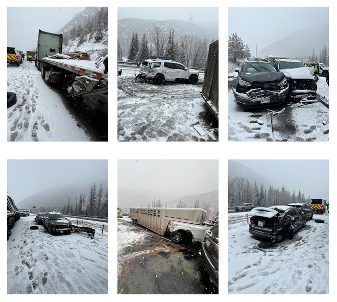
1.23.26, 9:35 p.m. – Between exit 116 – Glenwood Springs/Aspen and exit 119 – No Name at mile point 118.5 the roadway is reopened to traffic.
1.23.26, 8:30 p.m. – Crash on eastbound I-70 between exit 116 – Glenwood Springs/Aspen, and exit 119 – No Name, at mile point 118.5. Road closed, expect delays due to a crash.
Garfield County Emergency Communications Authority
1.23.26, 8:21 p.m. – I-70 is closed at mile marker 116 eastbound, Glenwood Springs exit, due to a multi-vehicle accident.
Garfield County Emergency Communications Authority
9.27.25, 12:40 am – I-70 is open at mile marker 130 westbound, Dotsero.
Colorado Department of Transportation
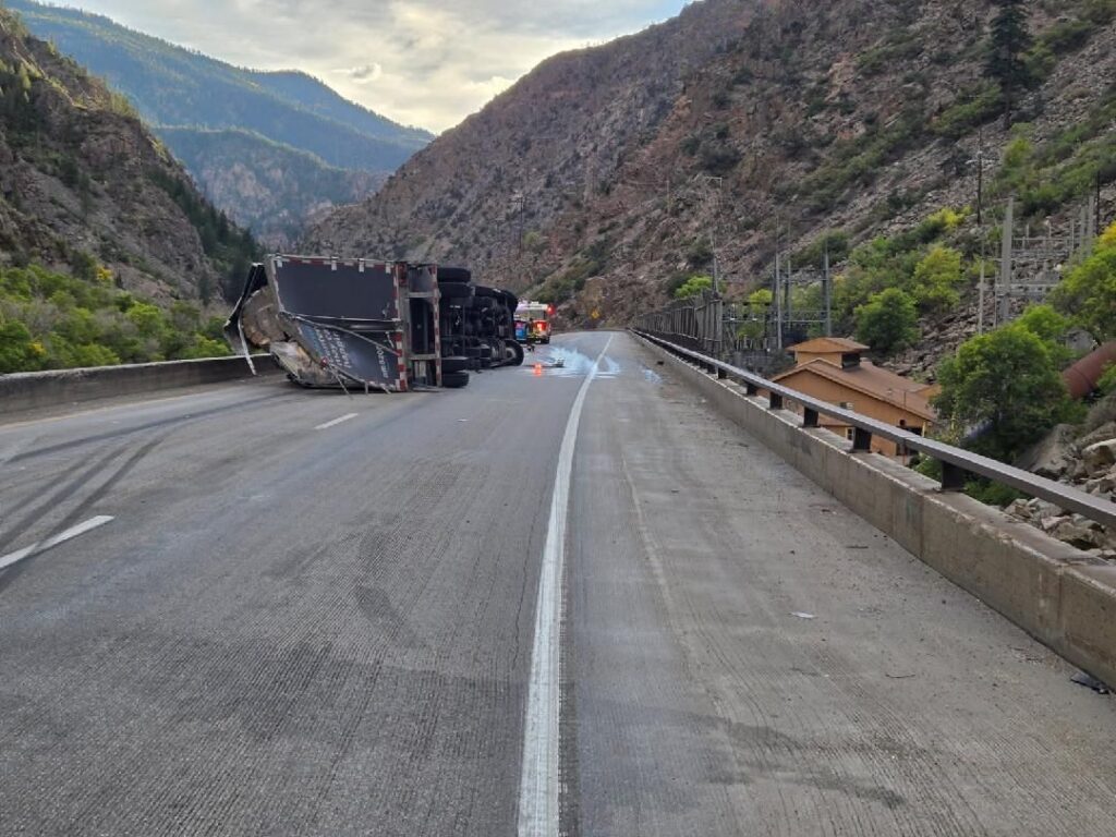
9.26.25, 9:03 pm – Westbound I-70 is closed to through traffic at Wolcott, Exit 157, due to a rolled over CMV crash that took place in Glenwood Canyon at around 6 p.m. this evening. CDOT and its partners worked tirelessly to avoid putting a detour in place — estimated to add four hours of travel time — but unfortunately, I-70 through Glenwood Canyon is an extremely challenging section of road with limited space for operations. There is no estimated time of re-opening.
The detour that is in place directs commuters onto US 6 via exit 157, Wolcott, north on HWY 131 toward Steamboat, west on US 40 towards Craig, south on HWY 13, and back on I-70 near Rifle.
Check COtrip.org or the #COtrip Planner app for more information and road updates.
CDOT photo of avalanche debris covering US 6/ Loveland Pass from the Seven Sisters slide paths that was remotely triggered using Gazex Avalanche Control System on Tuesday, Feb 17, by CDOT teams.
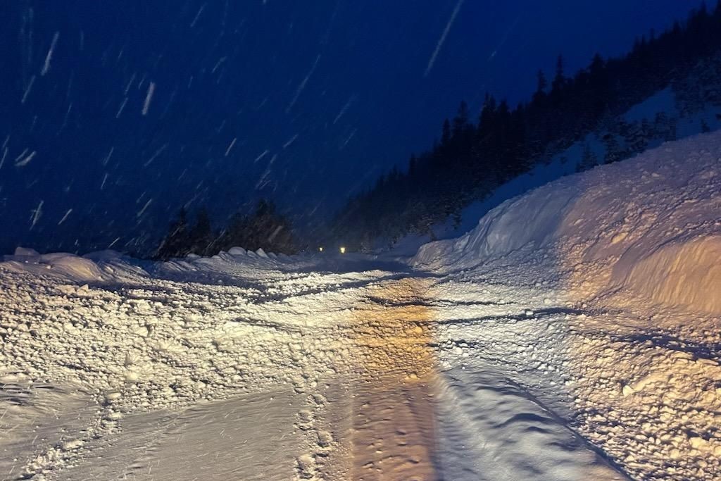
Winter operations teams have safely triggered and cleared avalanche slide paths along I-70 through the mountain corridor following successive storms from last Thursday night through Tuesday morning. Measurements taken this morning on the summit of Vail Pass counted 28 inches of snow and 2.2 inches of snow water equivalent.
Those storms brought heavy accumulations of snow and high winds, which made for extreme conditions over long stretches of the Presidents Day weekend. With high volumes of car and truck travel, CDOT crews and law enforcement cleared vehicle spinouts, in addition to clearing roads of snow throughout the extended holiday weekend. Some periods of time saw short and intense bursts of snow that impeded visibility.
“Mother Nature did not take off for the holiday weekend. To the contrary, we saw some of the most intense snow totals of the season in the high country and multiple consecutive storms. Mountain Corridor ski resorts reported more than a foot and a half of fresh snow in 48 hours and more than four feet of snow in the past seven days. CDOT crews have been working around the clock to clear roads and mitigate avalanche risk, including a number of mitigation missions this morning. We remind drivers that conditions remain challenging. Please drive carefully through the tail end of this weather system, and watch out for snow plows and law enforcement who are working hard to keep the roads safe,” said CDOT Executive Director Shoshana Lew.
Every winter, CDOT and its sister agency, the Colorado Avalanche Information Center (CAIC), regularly monitor and control 278 of 522 known avalanche paths located above Colorado highways. These efforts help prevent avalanches from impacting motorists on the highways below. When there is a high risk of avalanche danger, CDOT will close the highway at the location of the avalanche path to conduct avalanche control. After the highway is closed, CDOT crews bring down the unstable snow from the mountain side and clear all snow and debris from the roadway before reopening the highway to traffic.
Four avalanche slide paths between the Eisenhower-Johnson Memorial Tunnel and the town of Silverthorne released debris onto the lanes of I-70 early this morning as crews performed mitigation missions. I-70 was briefly closed while these slides were triggered and crews cleared the road.
“The mitigation methods used in the early morning hours, before daylight, allowed our crews to work when traffic volumes are low,” said CDOT Director of Maintenance and Operations Shawn Smith. “This work is critical for keeping our roads safe, especially after the volume of snow we have seen over the past few days. We appreciate drivers’ patience as the team performs this important work of triggering avalanches and subsequent cleanup, which significantly reduces the risk of natural slides.”
“CAIC forecasters have been busy reading the snowpack for both backcountry users and Colorado highways,” said Ethan Greene, Director of the CAIC. “With avalanche danger rated as HIGH in the Northern Mountains, we’ve been diligent about communicating this danger to the public and working closely with CDOT maintenance crews.”
During a later morning mission, crews performed essential winter maintenance operations on Vail Pass, between Exit 180/ East Vail and Exit 195/ Copper Mountain, around 9 a.m. with five snowslides mitigation and one reaching the interstate lanes, as much as four feet deep and 175 feet in length.
Visit COtrip.org for the latest information on road closures and conditions.
Visit the Colorado Avalanche Information Center’s website, colorado.gov/avalanche, for avalanche forecasts.
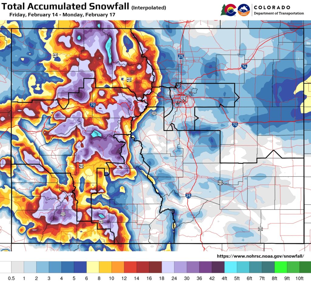
CDOT map indicating accumulated snowfall seen throughout the state from Friday, Feb. 14, through Monday, Feb. 17.
Winter travel alert: Treacherous conditions remain on I-70 mountain corridor for Presidents’ Day traffic – CDOT maintenance teams perform critical winter safety operations beginning at 9 a.m. Tuesday, Vail Pass to close for lengthy delay
12.17.25 Eagle County — Travelers on Interstate 70 are urged to be prepared for continued severe weather and treacherous driving conditions today. Motorists will encounter slick, ice and snow-packed roads. Additionally, heavy snows and strong winds will bring low visibility and potential whiteout conditions at times.
The severe weather and roadway conditions have caused numerous closures. Some closures have been implemented for safety, but several closures have been the result of vehicle spin-outs, slide-offs, and crashes.
CDOT photos above: Crash images captured from Monday’s I-70 westbound closure near Empire Junction/ Exit 232 and Georgetown/ Exit 228.
Natural avalanches have also been visible in the mountains today. While a video captured earlier today by the Colorado Avalanche Information Center (CAIC) showed an avalanche that did not reach the roadway of I-70 through Ten Mile Canyon, the danger of additional slides remains high. In addition, CDOT and CAIC teams saw results of slide control work on Berthoud Pass early this morning, after avalanche mitigation debris did reach the roadway. US 40 required clean-up and re-opened safely to vehicles.
Visitors to the high country who plan to return to the Front Range should prepare for a difficult trip. Travelers should keep extra food, water, and warm clothing readily available and be prepared for lengthy delays in severe weather conditions. COtrip.org will continue to show current road and weather conditions, as well as any road closures. Even so, the extreme weather conditions may cause additional incidents on the road as people try to return from the mountains while the storm continues to deliver heavy snowfall and high winds.
I-70 Vail Pass closure Tuesday morning
The Colorado Department of Transportation will perform winter maintenance operations on Interstate 70 Vail Pass tomorrow, Tuesday, February 18. Operations will begin at 9 a.m., and motorists can expect a lengthy delay lasting for much of the morning. There is not an exact time estimated for opening, as operations are dependent upon weather conditions and the amount of snow crews must clear from the roadway.
Traffic impacts and closure points
• Eastbound travelers will be stopped three miles east of Vail at exit 180. This closure point allows motorists to switch travel directions and turn westbound back toward Vail • Eastbound commercial traffic is urged to stop and wait at the Dotsero commercial motor vehicle parking lot, exit 133 • Westbound travelers will be stopped at exit 195 near Copper Mountain Motorists should plan ahead, allow for extra travel time, or arrive and drive through the closure points before the designated closure time of 9 a.m.
Visit COtrip.org for the latest information on road closures and conditions.
Travel alert – Sun glare safety closures on eastbound I-70 at Floyd Hill begin in November Motorists should expect delays in the early morning hours on sunny days I-70 Mountain Corridor — Sun glare season is here and that means on sunny mornings, eastbound Interstate 70 at Floyd Hill east of Idaho Springs will close from sunrise to 8:30 a.m. from early November through February. When closures occur, drivers traveling on eastbound I-70 should prepare for delays of up to an hour. The first closure could occur at sunrise on Sunday, Nov. 3 if the weather is clear and sunny.
The Colorado Department of Transportation (CDOT) and the Colorado State Patrol (CSP) want to remind drivers that the closures are necessary to prevent crashes because the sun glare on eastbound I-70 is blinding. The sun’s angle, in combination with the hill and the highway’s configuration, can create a blinding sun glare for drivers as they head eastbound up Floyd Hill (about Mile Points 244 to 248 – east of Idaho Springs). The intense sun glare occurs as far east as Genesee beginning around sunrise and lasting until around 8:30 a.m.
Detour route
If a sun glare safety closure is in place along eastbound I-70:
Traffic headed eastbound on I-70 will be rerouted at Exit 244 (US 6) which is at the bottom of Floyd Hill.
Motorists can either stay the course on US 6 through Clear Creek Canyon, or they can take the eastbound I-70 frontage road (US 40) and get back onto I-70 at Beaver Brook (Exit 248).
Truckers should be aware, there are height restrictions in the tunnels along US 6 Clear Creek Canyon, no vehicles over 12′ 7″ can travel this route.
The closures average around 45 minutes to an hour and can occur between sunrise and 8:30 a.m. from November through February each year.
Drivers who travel eastbound I-70 in the early morning hours during fall and winter are urged to pay attention to the overhead message boards beginning just east of the Eisenhower Johnson Memorial Tunnel. The signs will have the latest information on sun glare closures. Drivers can also check the travel alerts by going to COtrip.org.
The sun glare closures at Floyd Hill are for the safety of the traveling public. The decision is made on a case by case basis each morning with collaboration between CSP and CDOT personnel who are stationed near Floyd Hill. The eastbound sun glare can become blinding for drivers, especially when there is leftover moisture on the roadway from a storm or from pre-storm road treatment materials. On top of that, mountain driving conditions include steep hills, sharp turns, and possibly wildlife crossing the highway. For these reasons, the sun glare safety closures at Floyd Hill become necessary. This is a unified effort between CSP and CDOT to keep motorists as safe as possible.
Other driver recommendations
Adjust your eastbound I-70 travel plans near Floyd Hill to before sunrise or later in the morning. Prepare for a sun glare safety closure to occur if you are traveling eastbound up Floyd Hill between 7 a.m. and 8:30 a.m. on sunny days November through February.
Make sure your windshield is clean – inside and out. Ensure your vehicle has plenty of windshield wiper fluid.
Wear a good pair of sunglasses to provide shading.
Expect traffic slowdowns between 6:30 and 8:30 a.m. along I-70 eastbound near Floyd Hill, and adjust your speed to avoid sudden reactions.
Let off the accelerator and slow down gradually instead of slamming on the brakes, if suddenly blinded by the sun.
Road conditions can change quickly at this time of year. Drivers can check the latest road and weather conditions by going to COtrip.org.
Garfield County Emergency Communications Authority
10.11.24, 1:03 p.m. – I-70 is open at mile-marker 114 EB, West Glenwood Springs. Right lane at mile marker 116 EB, Glenwood Springs is still closed.
Colorado Department of Transportation
10.11.24, 6:09 a.m. – I-70 eastbound: Road closed. Between Exit 111: South Canyon and Exit 114: West Glenwood (Glenwood Springs) at Mile Point 114. Road closed expect delays due to a crash. Slower speeds are advised.
Garfield County Emergency Communications Authority
10.11.24, 4:40 a.m. – I-70 is closed at mile-marker 114 EB, West Glenwood Springs, due to an accident.
Garfield County Emergency Communications Authority
9.19.24, 1:50 p.m. – I-70 is open at mile-marker 116 EB, Glenwood Springs.
Colorado Department of Transportation
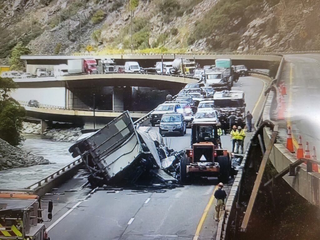
A commercial semi-truck crash occurred on I-70 about six miles east of Glenwood Springs on Tuesday. A full eastbound closure is scheduled for Thursday, 9/19 at 11 a.m. for additional cleanup.
September 19, 2024, 11:31 a.m. – Colorado Department of Transportation: A full eastbound closure began at 11 a.m. today in Glenwood Canyon. CDOT maintenance crews are completing the clean-up efforts from Tuesday’s semi-truck crash. Today’s eastbound closure is expected to last at least three hours.
The recommended alternate route takes travelers north, accessed at the town of Rifle, exit 87, then north along CO 13 to Craig. The route continues on US 40 to Steamboat, then south on CO 9 to Silverthorne where travelers may access I-70 again. Visit COtrip.org or download the COtrip Planner app for route details and closure updates.
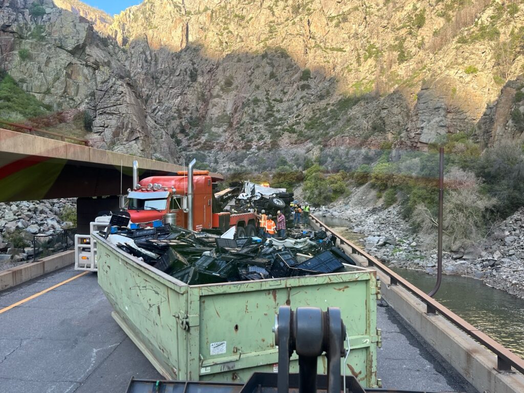
Immediately following the crash on Tuesday, crews hauled away several dumpsters filled with damaged freight and crash material. The crashed truck and trailer were also hauled away, but additional clean-up and road sweeping of debris is needed today.
Garfield County Emergency Communications Authority
9.19.24, 10:57 a.m. – Interstate 70 is closed at 11 a.m. at mile marker 116, Glenwood Springs, due to accident cleanup. There is no estimated time for reopening. Check COtrip for details. The Colorado Department of Transportation is noting that detour is in place I-70 eastbound at mile point 87 to direct traffic up CO-13, to US-40, and then to CO-9.
September 19, 2024, 9:02 a.m. – The planned 11 a.m. closure and clean-up of Interstate 70 in Glenwood Canyon is now postponed due to the US 40 rockslide. CDOT will update the public when that work and closure is rescheduled.
September 19, 2024, 9:02 a.m. – The planned 11 a.m. closure and clean-up of I-70 Glenwood Canyon is now postponed due to the US 40 rockslide. CDOT will update the public when that work and closure is rescheduled.
Travelers urged to consider the northern alternate route via Highways 13, 40 and 9
Crews have hauled away several dumpsters of debris from a commercial semi-truck crash that occured on I-70 about six miles east of Glenwood Springs yesterday. A full eastbound closure is schedule for today at 11 a.m. for additional cleanup.
9.18.24, 7:07 a.m. –I-70 Mountain Corridor — A full eastbound closure is set for 11 a.m. today in Glenwood Canyon. CDOT maintenance crews will complete the clean-up efforts from yesterday’s semi-truck crash. The mid-day closure will allow for early morning commuters to travel through the canyon. Today’s eastbound closure is expected to last several hours.
The recommended alternate route takes travelers north, accessed at the town of Rifle, exit 87, then north along CO 13 to Craig. The route continues on US 40 to Steamboat, then south on CO 9 to Silverthorne where travelers may access I-70 again. Visit COtrip.org or download the COtrip Planner app for route details and closure updates.
One lane of eastbound I-70 traffic opened last night at 9 p.m. Crews hauled away several dumpsters filled with damaged freight and crash material. The crashed truck and trailer were also hauled away, but additional clean-up and road sweeping of debris is needed today.
Garfield County Emergency Communications Authority
9.17.24, 9:13 p.m. – I-70 eastbound is open at mile marker 116 Glenwood Springs, left lane only. Right lane remains closed at this time.
Colorado Department of Transportation
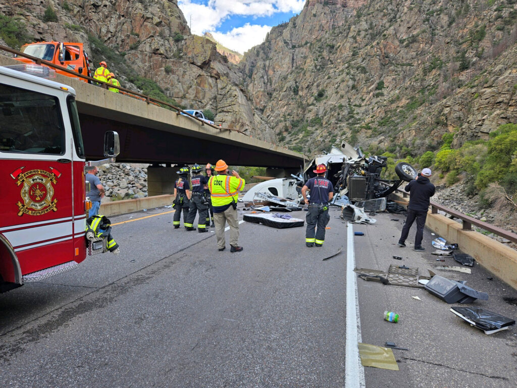
Commercial semi-truck crash closes eastbound lanes in Glenwood Canyon
Drivers urged to consider the northern alternate route via Highways 13, 40 and 9
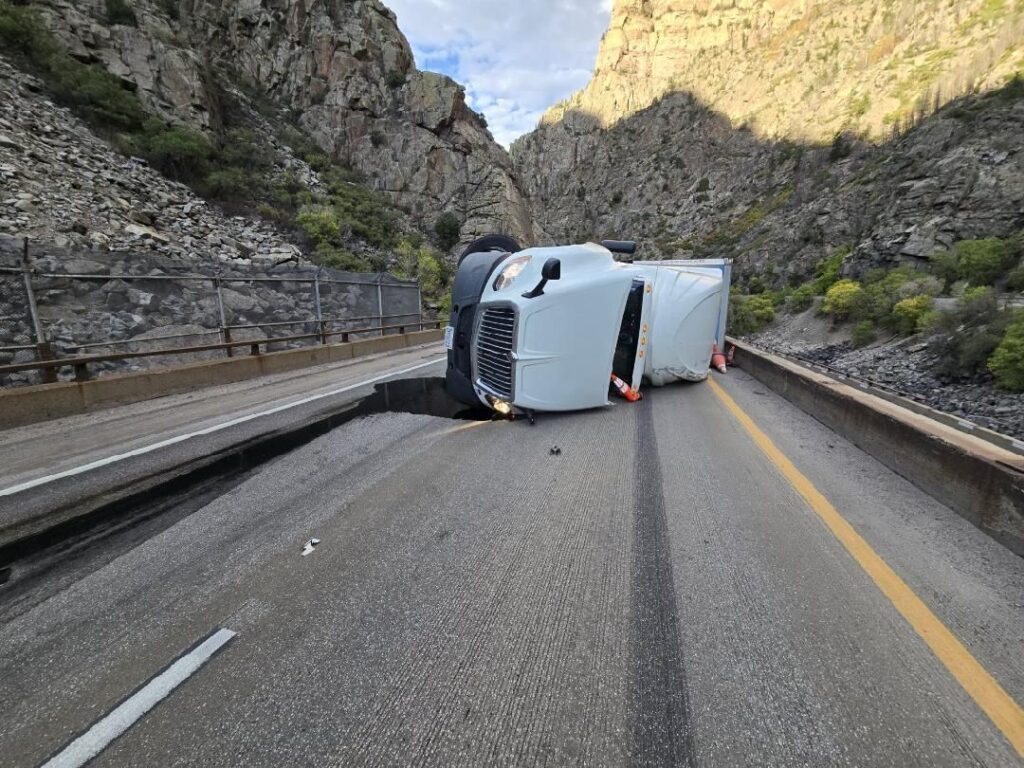
A commercial semi-truck crashed on I-70 about six miles east of Glenwood Springs at approximately 9:30 a.m. A closure remains in place for eastbound traffic.
9.17.24, 12:50 p.m. – I-70 Mountain Corridor — Eastbound lanes of the I-70 Mountain Corridor in Glenwood Canyon are closed. It is not known when the eastbound lanes will open. Interstate travelers are advised to avoid the area and seek the northern alternate route for east-west travel.
The northern alternate route can be accessed at the town of Rifle, exit 87, then north along CO 13 to Craig. The route continues on US 40 to Steamboat, then south on CO 9 to Silverthorne where travelers may access I-70 again. Visit COtrip.org for route details and closure updates.
I-70 westbound traffic is being allowed through the crash area. CDOT and the Colorado State Patrol urge drivers to slow down and abide by the speed reduction being enforced in the area.
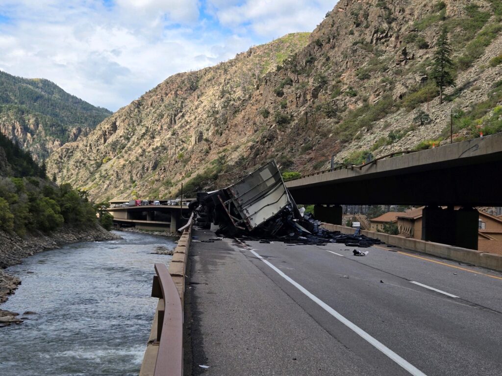
The closure is due to a commercial semi-truck that crashed about six miles east of Glenwood Springs at approximately 9:30 a.m. The CMV was traveling in the westbound lanes of I-70 when it crashed through the guardrail and landed on the eastbound lanes of the lower deck.
Emergency crews responded to a commercial semi-truck that crashed on I-70 about six miles east of Glenwood Springs at approximately 9:30 a.m. A closure remains in place for eastbound traffic.
A commercial semi-truck crashed on I-70 about six miles east of Glenwood Springs at approximately 9:30 a.m. A closure remains in place for eastbound traffic.
Garfield County Emergency Communications Authority
September 17, 2024, 11:47 a.m. – Colorado Department of Transportation: Between Exit 116: Glenwood Springs/Aspen and Exit 133: Dotsero from Mile Point 116.6 to Mile Point 133. Road closed expect delays due to roadwork. Detour in place. See map for detour(s). Until today at about 11 p.m. MDT.
September 17, 2024, 11:41 a.m. – Interstate 70 remains closed at mile-marker 123, Shoshone Exit, due to an accident. The westbound lanes are now open.
September 17, 2024, 9:49 a.m. – Interstate 70 is closed at mile-markers 122-123 in both directions, Shoshone Exit area, due to an accident.