Rocky Mountain Area Complex Incident Management Team 3
Casey Cheesbrough, Jay Miller, Ben Sanders Incident Commanders
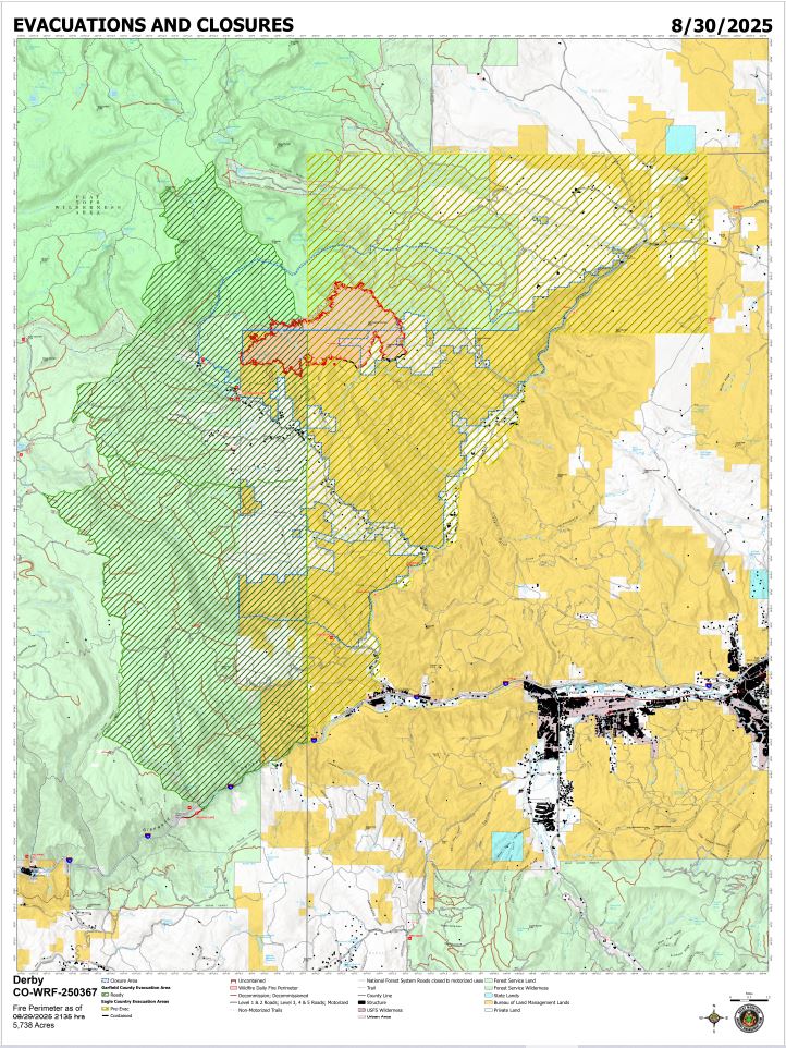
Derby Fire evacuation closure map
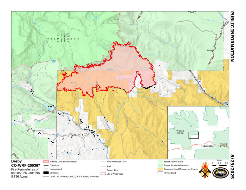
Derby Fire public information map
Derby Fire smoke outlook – English
Derby Fire smoke outlook – Spanish
Fire Information: 970-355-3283
Office Hours: 8 a.m. to 8 p.m.
Size: 5,738 acres
Total Personnel: 667
Containment: 6%
Cause: Lightning
Resources: 4 Aircraft | 16 Hand Crews | 36 Engines | 17 Heavy Equipment
Current Situation: Containment increased slightly on the south, west of East Fork Sheep Road. This is where interior heat has decreased, and wind and weather conditions are unlikely to push the fire over the control line. Firefighters continue to patrol, mop up, and extinguish hotspots along the southern control line. Hotshot crews continue to construct fireline along the fire edge on the western side as they progress to the north. Handline construction is progressing on the east side of the fire, extending northward from an existing dozer line. Air resources are evaluating proposed medical evacuation helispots as the firefighters move into more rugged, remote terrain. An Unmanned Aircraft System is also available to help assess fuels, fire behavior and areas of heat using an infrared camera. Structure protection crews are actively monitoring and maintaining defenses around more than 500 structures along Sweetwater Valley, Sheep Creek, and Red Dirt Creek Road.
Weather & Fire Behavior: Recent rainfall has kept relative humidity levels high, helping to minimize fire behavior. Saturday will see slowly clearing skies and sunshine with a slight possibility of rain at higher elevation. A gradual warming and drying trend are expected to begin on Sunday. Relative humidities will start to drop a little each day, however, a few days of drying will be needed before any significant increase in fire activity is likely. Interior heat pockets may continue to produce smoke where dead and downed trees are still smoldering. Fire may slowly creep along the ground in areas where mixed conifer, subalpine fir and lodgepole pine trees transition into aspen stands.
For air-quality and smoke outlook information:https://outlooks.wildlandfiresmoke.net/outlook/4d276598
Evacuations and Closures: Fire restrictions and closures remain in place for lands within the Bureau of Land Management – Colorado River Valley Field Office areas and White River National Forest. Find out more at their websites: https://www.blm.gov/ucr-fire-restrictions. See Critical and Fire Restriction Forest Alerts at https://www.fs.usda.gov/r02/whiteriver/alerts/
The Colorado River, Sweetwater, and Red Dirt Creek roads have all been reopened, and the Garfield County and Eagle County Sheriff’s Offices have changed the evacuation status for Sweetwater Valley, Sheep Creek and Red Dirt Creek areas to pre-evacuation (READY) status: https://arcg.is/S0u4G and www.ecemergency.org.
A Temporary Flight Restriction (TFR) is in place over the Derby Fire. All unauthorized aircraft (including drones) are prohibited from flying near the fire, as they can interfere with authorized air support operations. For more information, visit https://tfr.faa.gov.
Derby Fire Information
Public Phone Line: (970) 355-3283
Office Hours: 8 a.m. to 8 p.m.
Actualización Diaria para el Incendio Derby –el 30 de agosto de 2025
Equipo 3 del Manejo de Incidentes Complejos del Área de las Montañas Rocosas
Comandantes del Incidente: Casey Cheesbrough, Jay Miller, Ben Sanders
Información del incendio: 970-355-3283
Acres: 5,738
Personal: 667
Contención: 6%
Causa: Rayos
Recursos: 4 aeronaves | 16 cuadrillas | 36 camiones de bomberos | 17 equipo pesados
Situación Actual: La contención aumentó ligeramente al sur, al oeste de East Fork Sheep Road. Aquí es donde el calor interior ha disminuido, y es improbable que las condiciones de viento y clima impulsen el incendio más allá de la línea de control. Los bomberos continúan patrullando, haciendo liquidación y extinguiendo los puntos calientes a lo largo de la línea de control sur. Los equipos de bomberos continúan construyendo una línea de fuego a lo largo del borde del incendio en el lado oeste a medida que avanzan hacia el norte. La construcción de la línea de fuego manual avanza en el lado este del incendio, extendiéndose hacia el norte desde una línea de bulldozer existente. Los recursos aéreos están evaluando los helipuertos propuestos de evacuación médica a medida que los bomberos se adentran en terrenos más accidentados y remotos. Un Sistema de Aviación No Tripulada (dron) también está disponible para ayudar a evaluar los combustibles, el comportamiento del incendio y las áreas de calor mediante una cámara infrarroja. Los equipos de protección de estructuras están monitoreando y manteniendo activamente las defensas alrededor de más de 500 estructuras a lo largo de Sweetwater Valley, Sheep Creek y Red Dirt Creek Road.
Clima y el comportamiento del fuego: Las lluvias recientes han mantenido altos los niveles de humedad relativa, lo que ha ayudado a minimizar el riesgo de incendio. El sábado se despejará lentamente el cielo y habrá sol, con una ligera probabilidad de lluvia en zonas de mayor altitud. Se espera que el domingo comience una tendencia gradual de calentamiento y sequía. La humedad relativa comenzará a descender ligeramente cada día; sin embargo, se necesitarán algunos días de sequía antes de que sea probable un aumento significativo de la actividad del incendio. Es posible que las bolsas de calor interiores sigan produciendo humo donde los árboles muertos y caídos aún arden lentamente. El fuego podría extenderse lentamente por el suelo en zonas donde las coníferas mixtas, los abetos subalpinos y los pinos contortos se transforman en álamos.
Para información sobre la calidad el aire y la perspectiva de humo, visite: https://outlooks.wildlandfiresmoke.net/outlook/es/4d276598
Evacuaciones y cierres: Las restricciones y cierres por incendios se permanecen vigentes en los terrenos bajo la administración de la Oficina de Administración de Tierras del Valle del Río Colorado y el Bosque Nacional White River. Para más información, visite su sitio web: https://www.blm.gov/ucr-fire-restrictions. Consulte las alertas forestales críticas y de restricciones por incendios en https://www.fs.usda.gov/r02/whiteriver/alerts/.
Se han reabierto los caminos Colorado River Road, Sweetwater Road y Red Dirt Creek. Los condados Eagle y Garfield han cambiado el estado de evacuación para los residentes de Sweetwater Valley, Sheep Creek, y Red Dirt Creek a “LISTOS”, la etapa 1 del proceso de evacuaciones que significa que “esté preparados”: https://arcg.is/S0u4G o https://sites.google.com/eaglecounty.us/ecemergencyespanol/inicio.
Se ha establecido una Restricción Temporal de Vuelo (TFR) sobre el incendio Derby. Se prohíbe a todas las aeronaves no autorizadas (incluidos los drones) volar cerca del incendio, ya que pueden interferir con las operaciones de apoyo aéreo autorizadas. Para más información, visite https://tfr.faa.gov.
Información sobre el Incendio Derby
Teléfono: 970-355-3283 (de 8:00 a. m. a 8:00 p. m.)
Correo electrónico: 2025.Derby@firenet.gov