Garfield County Sheriff’s Office
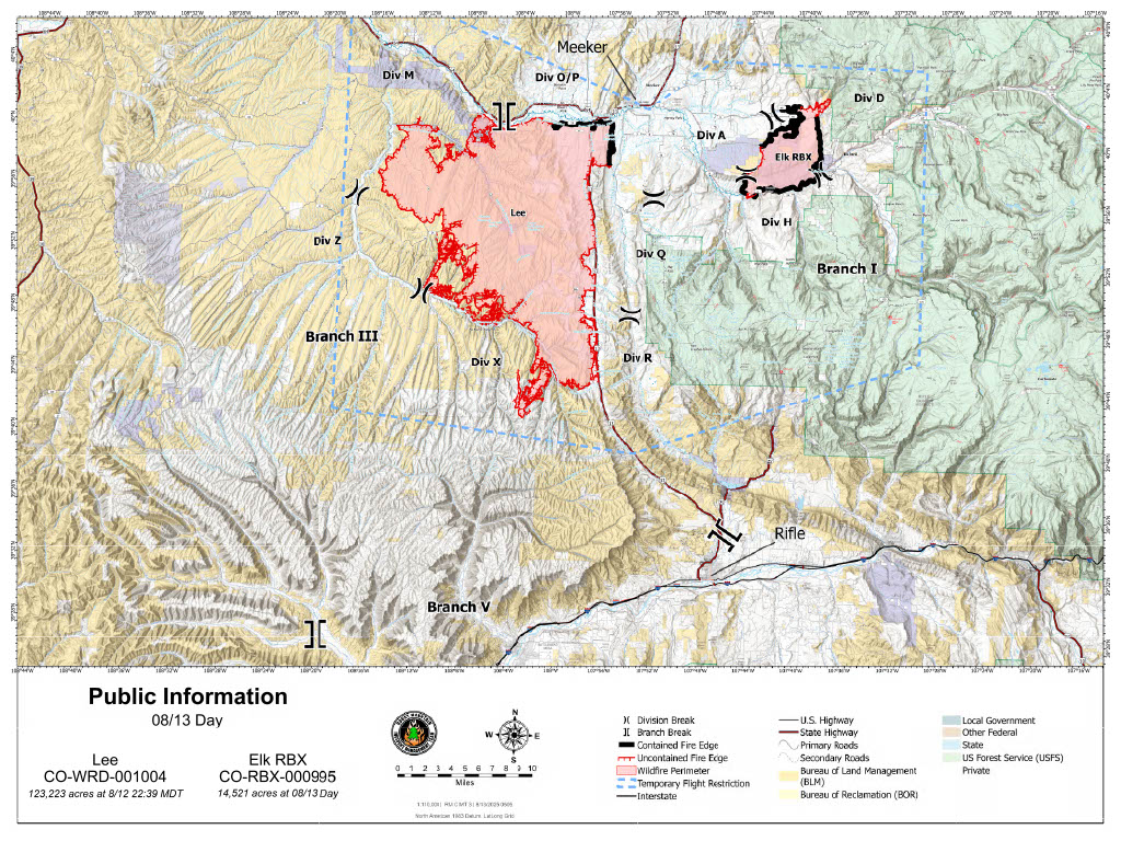
Zone 81 is in GO (red)
Zone 85 is in SET (yellow)
Zone 84 is in READY (green)
Check your zone on this map: https://bit.ly/lee-fire-zones
The southern edge of the Lee Fire has reached the Garfield County line, prompting the above changes to evacuation status.
Zone 81 and 85 are on top of the Roan Plateau in industrial landscape and BLM area (already under a closure), not residential areas.
Fire managers’ strategic planning includes multiple secondary and contingency lines between the fire’s edge and the southern edge of the Roan Plateau.
As a reminder:
GO = Evacuate immediately from your area. Leave now – danger in your area.
SET = Short notice evacuation likely in your area. Prepare for sudden evacuations. Leave now if you need extra time.
READY = Possible evacuation in your area. Prepare, monitor, and pack your valuables.

INTERACTIVE EVACUATION MAP: http://bit.ly/lee-fire-zones
Garfield County: REGISTER FOR ALERTS – garco911.com
INCIDENT UPDATES/SUBSCRIBE – garfieldcounty.net
FACEBOOK – facebook.com/garcosheriff
Elk and Lee Fire Information page: https://www.facebook.com/elkleefire
Oficina del Sheriff del Condado de Garfield
La zona 81 está en GO (rojo)
La zona 85 está en SET (amarillo)
La zona 84 está en LISTO (verde)
Consulta tu zona en este mapa: https://bit.ly/lee-fire-zones
El borde sur del incendio Lee ha llegado a la línea del condado de Garfield, lo que provocó los cambios mencionados anteriormente en el estado de evacuación.
Las zonas 81 y 85 están en la parte superior de la meseta de Roan en el paisaje industrial y el área BLM (ya bajo cierre), no son áreas residenciales.
La planificación estratégica de los administradores de incendios incluye múltiples líneas secundarias y de contingencia entre el borde del incendio y el borde sur de la meseta de Roan.
Como recordatorio:
SALIR = Evacuar inmediatamente su zona. Salga ahora: peligro en su zona.
SET = Posible evacuación con poca antelación en su zona. Prepárese para evacuaciones repentinas. Salga ahora si necesita más tiempo.
PREPARADO = Posible evacuación en su zona. Prepare, vigile y empaque sus objetos de valor.
MAPA DE EVACUACIÓN INTERACTIVO: http://bit.ly/lee-fire-zones
Condado de Garfield: REGÍSTRESE PARA RECIBIR ALERTAS – garco911.com
ACTUALIZACIONES DE INCIDENTES/SUSCRÍBASE – garfieldcounty.net
FACEBOOK – facebook.com/garcosheriff
Página de información sobre incendios de Elk y Lee: https://www.facebook.com/elkleefire