Eagle County Sheriff’s Office, Garfield County Sheriff’s Office, Eagle County Emergency Operations Center
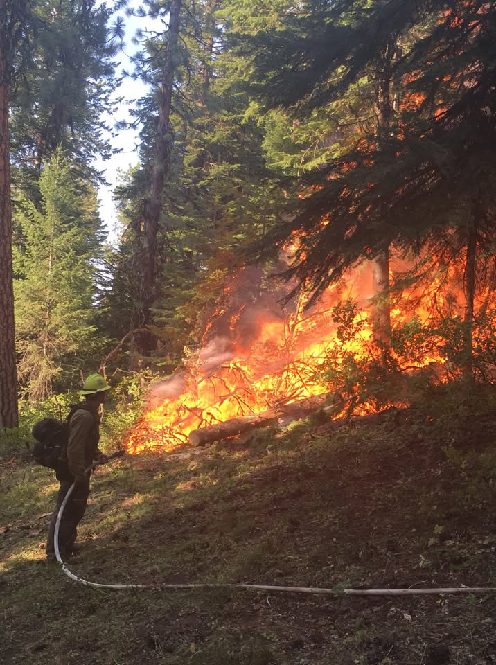
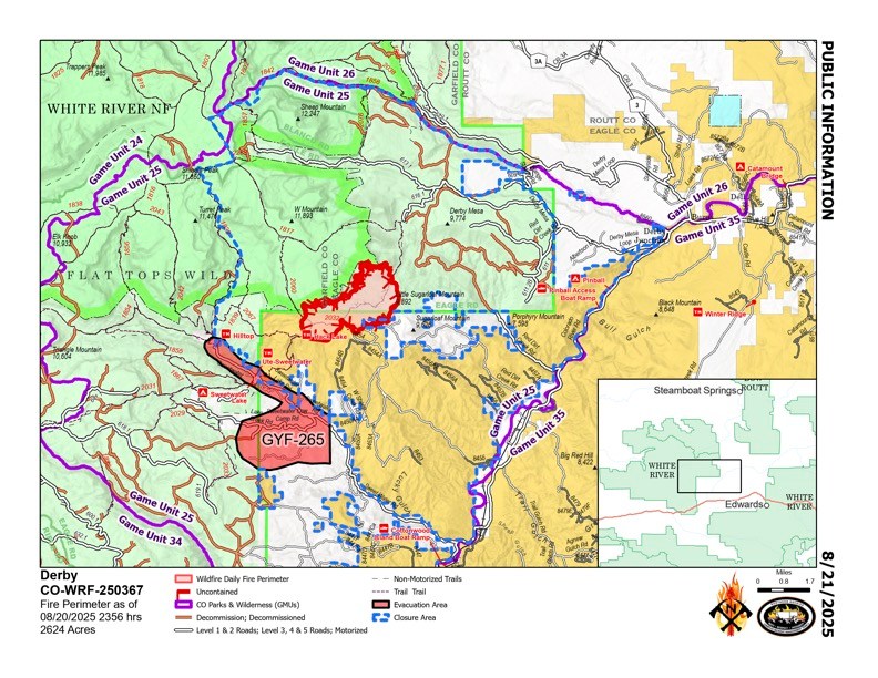
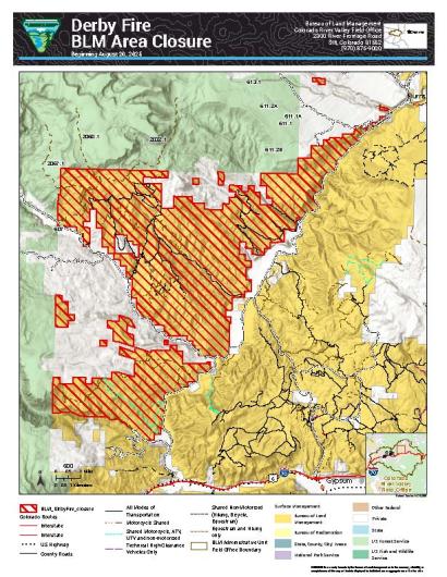
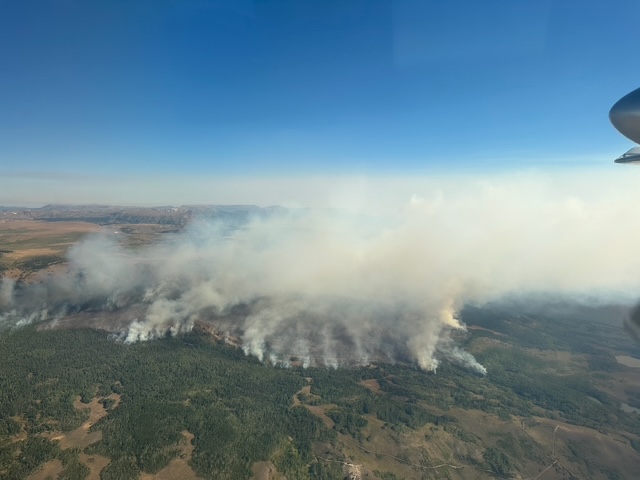
August 21, 10:45 a.m. – The Derby Fire grew to more than 2600 acres in the past two days. Winds are moving in a southward direction today, August 21, and outflow winds pushing downward risk fire spread today.
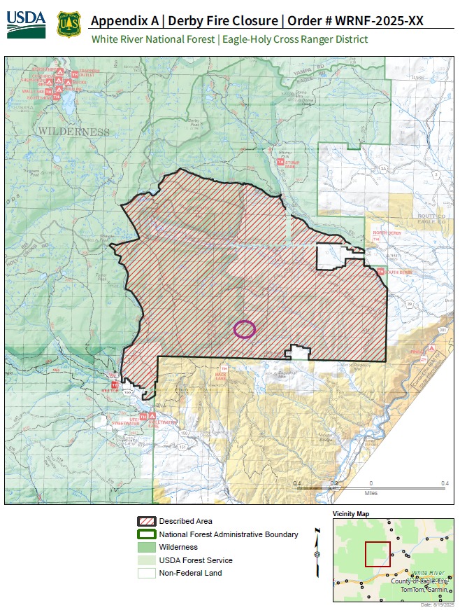
Eagle County: Zone 266-A along the Colorado River Road has been moved to pre-evacuation status. The Colorado River Road remains closed to non-residents and unapproved traffic. Evacuations remain in place for Sweetwater and Red Dirt Creek.
Leave evacuated areas now for your immediate safety.
Evacuations remain in place for zones 327, 330, 266, 264, and 265, including Sweetwater Road and sections of the Colorado River Road from Sweetwater to Red Dirt Creek both in Eagle and Garfield counties. Click on the map to identify the zones: Genasys Protect.
SWEETWATER, SWEETWATER LAKE AND TO WEST END OF CR 150 – Evacuation in place
COLORADO RIVER ROAD – Evacuation in place
DERBY MESA – Pre-evacuation, prepare to leave, monitor updates
Follow directions from authorities.
For evacuation questions, please call the Eagle County Evacuation information line: 970-328-7400.
Evacuated areas are lawfully closed to public access.
Eagle County’s evacuation center
Gypsum Recreation Center, 52 Lundgren Blvd, Gypsum, is open from 9 a.m. to 5 p.m.
Services available at the Evacuation Center include: information sharing, resource connection, showers, restroom facilities and light refreshments. It is located near The Salvation Army Canteen that provides meals for evacuees and first responders.The evacuation center is not accepting or in need of any donations at this time. Monetary donations can be made to the Salvation Army.
Parking at the Eagle Sports Complex for evacuees
The Eagle Sports Complex parking lot is available for evacuees to park and camp, providing easy access to their livestock being sheltered at the fairgrounds.
Move animals to safety
For anyone seeking support for livestock and animal evacuations, please contact Connie Melzer of CSU Extension, 970-471-8043. The Eagle County Fairgrounds are closed to public use at this time.
For support with smaller animals, dogs and cats, please call the Eagle County Animal Services #970-471-3763.
Smoke impacts
If visibility is less than 5 miles, smoke has reached levels that are unhealthy. Stay indoors and consider creating a clean air space or leaving the area temporarily.
The fire is now managed by the Northern Rockies Complex Incident Management 3 team.
Derby Fire email
2025.derby@firenet.gov
Derby Fire phone
For Derby Fire questions, please contact: 970-355-3283.
Derby Fire official information:
FACEBOOK – Derby fire @derbyfire
INCIWEB – Derby Fire
WHITE RIVER NATIONAL FOREST – facebook.com/whiteriverNF @whiteriverNF
_______________
EAGLE COUNTY INFO
REGISTER FOR ALERTS – 911 alerts
INCIDENT UPDATES – EC Emergency or Reachwell app
FACEBOOK – facebook.com/eaglecountyso @eaglecountyso
________________
GARFIELD COUNTY INFO
REGISTER FOR ALERTS – 911 alerts or Reachwell app
INCIDENT UPDATES / SUBSCRIBE – Garfield County emergency
FACEBOOK – facebook.com/garcosheriff @garcosheriff
Allow government alerts on your mobile phone (like Amber alerts) to receive emergency alerts released for geographical areas.
For areas without cell service, consider using a GPS device that allows satellite notifications.
Incendio de Derby: abandone las áreas evacuadas por seguridad
Oficina del Sheriff del Condado de Eagle, Oficina del Sheriff del Condado de Garfield, Centro de Operaciones de Emergencia del Condado de Eagle
21 de agosto, 10:45 a. m. – El incendio Derby se extendió a más de 2600 acres en los últimos dos días. Los vientos se mueven hacia el sur hoy, 21 de agosto, y los vientos de salida que empujan hacia abajo podrían provocar la propagación del incendio.
Condado de Eagle: La zona 266-A a lo largo de Colorado River Road ha sido puesta en estado de preevacuación. Colorado River Road permanece cerrada al tráfico no autorizado y a los no residentes. Se mantienen las evacuaciones en Sweetwater y Red Dirt Creek.
Abandone las áreas evacuadas ahora para su seguridad inmediata .
Se mantienen las evacuaciones en las zonas 327, 330, 266, 264 y 265, incluyendo Sweetwater Road y tramos de Colorado River Road desde Sweetwater hasta Red Dirt Creek, en los condados de Eagle y Garfield. Haga clic en el mapa para identificar las zonas: Genasys Protect .
SWEETWATER, SWEETWATER LAKE Y HASTA EL EXTREMO OESTE DE LA CR 150: Evacuación en marcha.
COLORADO RIVER ROAD: Evacuación en marcha.
DERBY MESA: Preevacuación, prepárese para partir, esté atento a las actualizaciones
. Siga las instrucciones de las autoridades.
Para preguntas sobre evacuación, llame a la línea de información de evacuación del Condado de Eagle: 970-328-7400.
Las áreas evacuadas están legalmente cerradas al público.
Centro de evacuación del condado de Eagle
El Centro de Recreación Gypsum, 52 Lundgren Blvd, Gypsum, está abierto de 9 a. m. a 5 p. m.
Los servicios disponibles en el Centro de Evacuación incluyen: intercambio de información, conexión con recursos, duchas, baños y refrigerios. Está ubicado cerca de la cantina del Ejército de Salvación, que ofrece comidas a evacuados y personal de primera respuesta. El centro de evacuación no acepta ni necesita donaciones actualmente. Se pueden hacer donaciones monetarias al Ejército de Salvación.
Estacionamiento en el Complejo Deportivo Eagle para evacuados
El estacionamiento del Complejo Deportivo Eagle está disponible para que los evacuados puedan estacionar y acampar, proporcionando fácil acceso a su ganado que se encuentra refugiado en el recinto ferial.
Trasladar a los animales a un lugar seguro
Si necesita ayuda para la evacuación de ganado y animales, comuníquese con Connie Melzer, de la Extensión de la CSU, al 970-471-8043. El recinto ferial del condado de Eagle está cerrado al público en este momento.
Para obtener ayuda con animales más pequeños, perros y gatos, llame a los Servicios para Animales del Condado de Eagle al # 970-471-3763.
Impactos del humo
Si la visibilidad es inferior a 8 kilómetros, el humo ha alcanzado niveles insalubres. Permanezca en el interior y considere crear un espacio de aire limpio o abandonar el área temporalmente.
El incendio ahora está siendo controlado por el equipo de Gestión de Incidentes 3 del Complejo Northern Rockies.
Correo electrónico de Derby Fire
: 2025.derby@firenet.gov
Teléfono de Derby Fire
Para preguntas sobre Derby Fire , comuníquese al: 970-355-3283.
Información oficial de Derby Fire:
FACEBOOK – Derby Fire @derbyfire INCIWEB – Derby Fire BOSQUE NACIONAL WHITE RIVER – facebook.com/whiteriverNF @whiteriverNF
_______________
INFORMACIÓN DEL CONDADO DE EAGLE
REGÍSTRESE PARA RECIBIR ALERTAS – Alertas del 911 ACTUALIZACIONES DE INCIDENTES – Aplicación EC Emergency o Reachwell FACEBOOK – facebook.com/eaglecountyso @eaglecountyso
________________
INFORMACIÓN DEL CONDADO DE GARFIELD
REGÍSTRESE PARA RECIBIR ALERTAS – Alertas del 911 o aplicación Reachwell ACTUALIZACIONES DE INCIDENTES / SUSCRÍBASE – Emergencia del condado de Garfield FACEBOOK – facebook.com/garcosheriff @garcosheriff
Permita que las alertas gubernamentales en su teléfono móvil (como las alertas Amber) reciban alertas de emergencia publicadas para áreas geográficas.
Para áreas sin servicio celular, considere usar un dispositivo GPS que permita notificaciones satelitales.