Northern Rockies Complex Incident Management Team 3, Incident Commander Mike Behrens
Derby Fire update document
Derby Fire update document – Spanish
Derby Fire smoke outlook
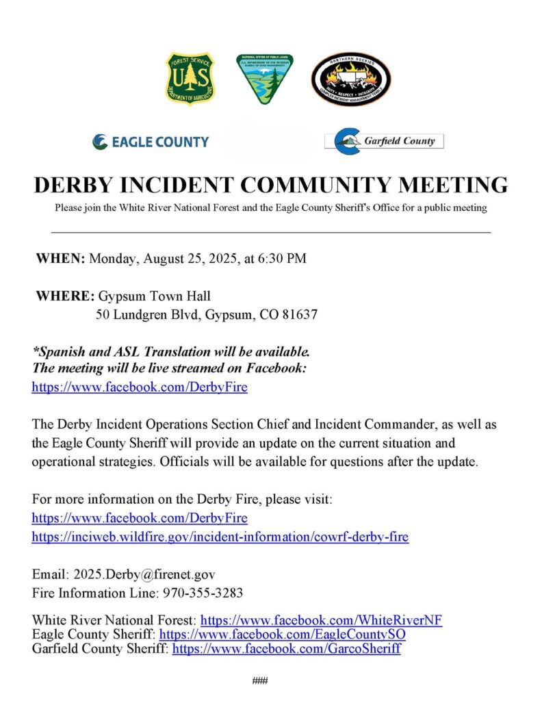
Derby Fire community meeting flyer 8/25/25
Location: 13 miles north of Dotsero, CO
Start Date: 8/16/2025;
Cause: Lightning
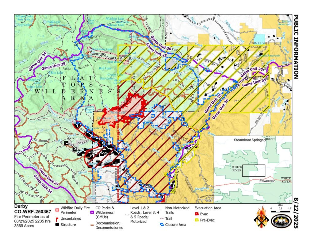
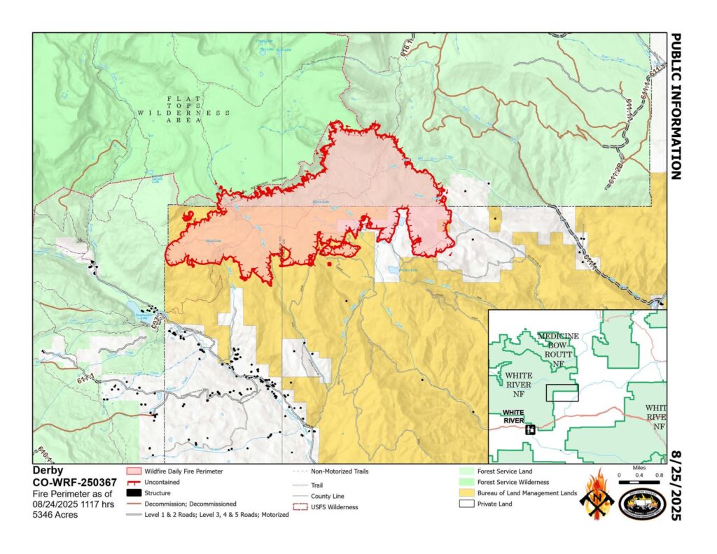
Size: Est. 5346 acres
Completion/Containment: 0%
648 total personnel
Key Message:
A Community Meeting will be held Monday, Aug. 25, 6:30 PM at the Gypsum Town Hall. It will be live streamed on the Derby Fire Facebook page and simulcast in Spanish on https://www.youtube.com/@DerbyFireInformation.
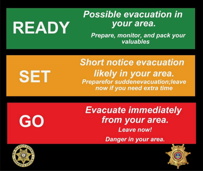
The Garfield County and Eagle County Sheriff’s Offices have changed the evacuation status for Sweetwater Valley and Sheep Creek to pre-evacuation (SET) status.
Current Status:
About three quarters of the recent growth on the fire’s southeast flank has been halted with new control lines.
The fire is growing slowly on other parts of its south perimeter, where firefighters are constructing control lines from a network of roads, dozer line, and hand line. On Sunday they worked to strengthen and widen those fire lines and will continue through the next several days as weather and conditions permit. Structure protection crews are working along Red Dirt Creek Road. Across the fire they have prepared over 500 structures by positioning sprinkler kits and removing surrounding fuels. Air support assisted by dropping flame retardant and water on the fire’s southeast flank.
Weather and Fire Behavior:
On Sunday, light but wetting rains fell on the Derby Fire, and the chance for monsoonal rain possibly accompanied by lighting will continue through most of the week. Daytime smoke and nighttime fire glows may be visible.
Closures and Special Messages:
Garfield and Eagle Counties have changed the evacuation status for Sweetwater Valley and Sheep Creek to pre-evacuation (SET). Zones GYF-263, 266-A, 267, 300, 366, and 369 are in pre-evacuation status. More evacuation information is available at https://arcg.is/S0u4G and www.ecemergency.org, including where to shelter and resources for pets and livestock.
The Colorado River Rd remains closed to non-residents and unapproved traffic at the roundabout north of Dotsero to Red Dirt Rd. Note that Coffeepot Rd. cannot be accessed from its intersection with Colorado River Rd.
The Forest Service and BLM have both issued public closure orders in the vicinity of the fire to protect public and firefighter safety. The White River National Forest’s closure order and map are posted at https://www.fs.usda.gov/r02/whiteriver/alerts/expanded-derby-fire-closure. The BLM Colorado River Valley Field Office’s closure order and map are posted at https://www.blm.gov/announcement/blm-issues-land-closure-garfield-and-eagle-counties-firefighting-activities. A Temporary Flight Restriction (TFR) is in place over the Derby Fire.
Please find attached a pdf of the Smoke Outlook for the Derby Fire in NW Colorado. Detailed forecasts for specific locations are available here: https://outlooks.wildlandfiresmoke.net/outlook/4d276598?
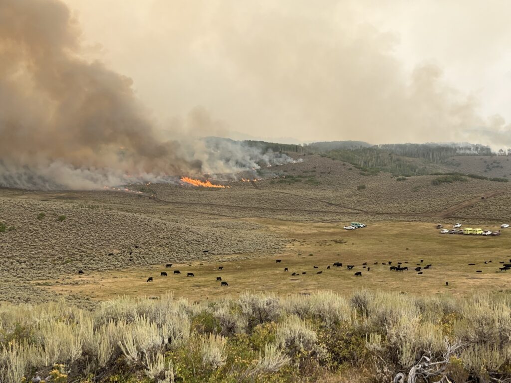
Cows grazing in the foreground with staged fire engines while the Derby Fire burns across the foothills in the background. Photo by Matt Butler/Derby Fire.
Incedio Derby
Bosque Nacional White River
Información sobre incendios: 970-355-3283 2025; Derby@firenet.gov; https://inciweb.wildfire.gov/incident-information/cowrf-derby-fire
24 de agosto 2025
Equipo 3 de Gestión de Incidentes Complejos de las Montañas Rocosas del Norte,
Comandante de Incidente Mike Behrens
Ubicación: 13 millas al oeste de Dotsero, CO
Fecha de inicio: 08/16/2025;
Causa: Rayos
Tamaño: Est. 5346 acres
Finalización/Contención: 0%
648 Personal total
Mensaje clave:
Habrá una reunión comunitaria el lunes, el 25 de agosto a las 6:30pm en el Gypsum Town Hall. Se transmitirá en vivo por la página de Facebook de Derby Fire y simultáneamente en español en https://www.youtube.com/@DerbyFireInformation. Las Oficinas del Condado de Eagle y del Sheriff del Condado de Garfield han cambiado el estado de evacuación de Sweetwater Valley y Sheep Creek a “LISTOS”, la etapa 2 del proceso de evacuaciones que significa “prepárese y esté alerta”.
Estado actual:
Aproximadamente tres cuartas partes del reciente crecimiento en el flanco sureste del incendio se han detenido con nuevas líneas de control. El incendio crece lentamente en otras partes de su perímetro sur, donde los bomberos están construyendo líneas de control a partir de una red de carreteras, una línea de excavadoras y una línea de mano. El domingo, trabajaron para reforzar y ampliar estas líneas de control y continuarán durante los próximos días si el clima y las condiciones lo permiten. Los equipos de protección de estructuras trabajan a lo largo de Red Dirt Creek Road. Al otro lado del incendio, han preparado más de 500 estructuras mediante la instalación de equipos de rociadores y la retirada de los combustibles circundantes. Se brindó apoyo aéreo con el lanzamiento de retardante de llama y agua en el flanco sureste del incendio.
Comportamiento del clima y el fuego
El domingo, cayeron lluvias sobre el incendio de Derby, y la probabilidad de lluvias monzónicas, posiblemente acompañadas de rayos, continuará durante la mayor parte de la semana. Podría verse humo diurno y resplandores de incendios nocturnos.
Cierres y mensajes especiales
Los condados Eagle y Garfield han cambiado el estado de evacuación para los residentes de Sweetwater Valley y Sheep Creek a “SET”, la etapa 2 del proceso de evacuaciones que significa “prepárese y esté alerta”. Las zonas GYF-263, 266-A, 267, 300, 366 y 369 están en estado previo a la evacuación. Para más información, incluido dónde refugiarse y recursos para mascotas y ganado, visite https://sites.google.com/eaglecounty.us/ecemergencyespanol/inicio.
El Colorado River Road permanece cerrado para todos aquellos que no sean residentes y el tráfico no autorizado en la rotonda al norte de Dotsero hasta Red Dirt Road. Tenga en cuenta que no se puede acceder a Coffeepot Road desde su intersección con Colorado River Road.
El Servicio Forestal y BLM han emitido órdenes de cierre público en las cercanías del incendio para proteger la seguridad pública y de los bomberos. La orden de cierre y el mapa del Bosque Nacional White River están publicados en https://www.fs.usda.gov/r02/whiteriver. La orden de cierre y el mapa de la Oficina de Campo del Valle del Río Colorado de BLM se publican en https://www.blm.gov/announcement/blm-issues-land-closure-garfield-and-eagle-counties-firefighting-activities. Existe una restricción temporal de vuelo (TFR por sus siglas en inglés) sobre el incendio de Derby.
Derby Fire official information:
FACEBOOK – Derby fire @derbyfire
INCIWEB – Derby Fire
WHITE RIVER NATIONAL FOREST – facebook.com/whiteriverNF @whiteriverNF
_______________
EAGLE COUNTY INFO
DERBY FIRE: EAGLE COUNTY EVACUATION MAP
REGISTER FOR ALERTS – 911 alerts
INCIDENT UPDATES – EC Emergency or Reachwell app
FACEBOOK – facebook.com/eaglecountyso @eaglecountyso
________________
GARFIELD COUNTY INFO
DERBY FIRE: GARFIELD COUNTY INTERACTIVE EVACUATION MAP
REGISTER FOR ALERTS – 911 alerts or Reachwell app
INCIDENT UPDATES / SUBSCRIBE – Garfield County emergency
FACEBOOK – facebook.com/garcosheriff @garcosheriff