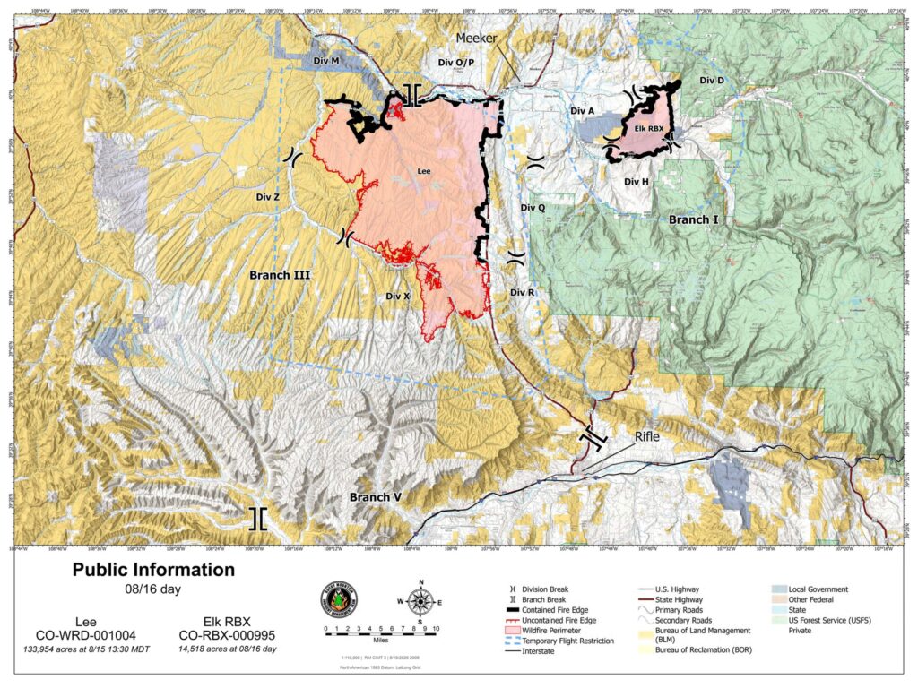
Evening Update – August 16th Elk Fire: 14,518 acres | 100% contained Lee Fire: 137,453 acres | 42% contained
8.16.25, 7:42 pm – Firefighters continued to mop up and secure firelines today, targeting areas where the fire was creeping and smoldering. The increased acreage on the Lee Fire is a result of interior pockets that have burned out and more precise mapping. There has been no change to containment lines. The southern part of the Lee Fire received .25 to .5 inches of rain this afternoon, with trace amounts on the northern portion. There is a chance of rain again tonight, however warmer and drier conditions are expected as we go into early next week.
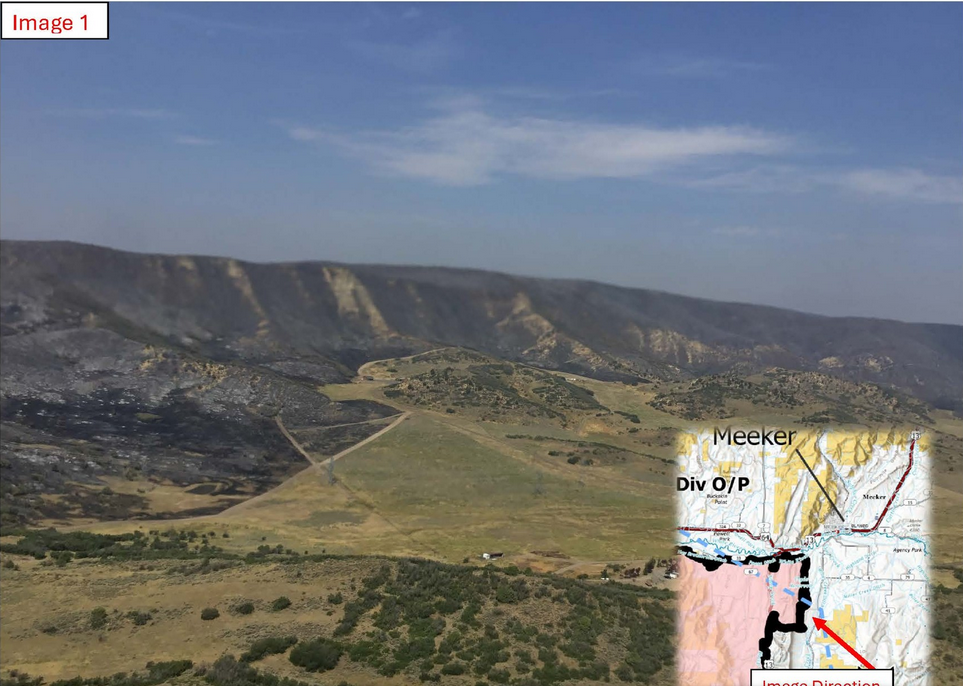
Air Operations provided these images of fire impacted areas. These images also illustrate protection efforts of values at risk.
Image 1: Looking west from just south of Meeker, Colorado. The burned area is referred as the Hogback and is where the Lee Fire had crossed Highway 13 on Wednesday August 6, 2025. The image was taken from Air Operations on August 14, 2025.
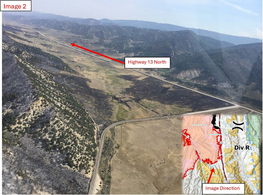
Image 2: This is an image from Air Operations on August 14, 2025, of the intersection of County Road 5 and Highway 13. This is the southeast edge of the fire where strategic firing operations were conducted to improve the road systems as a holding point with the highest probability of success. These firing operations remove fuels to allow firefighters the opportunity to go direct and hold the fire as it approaches and runs out of fuels to burn.
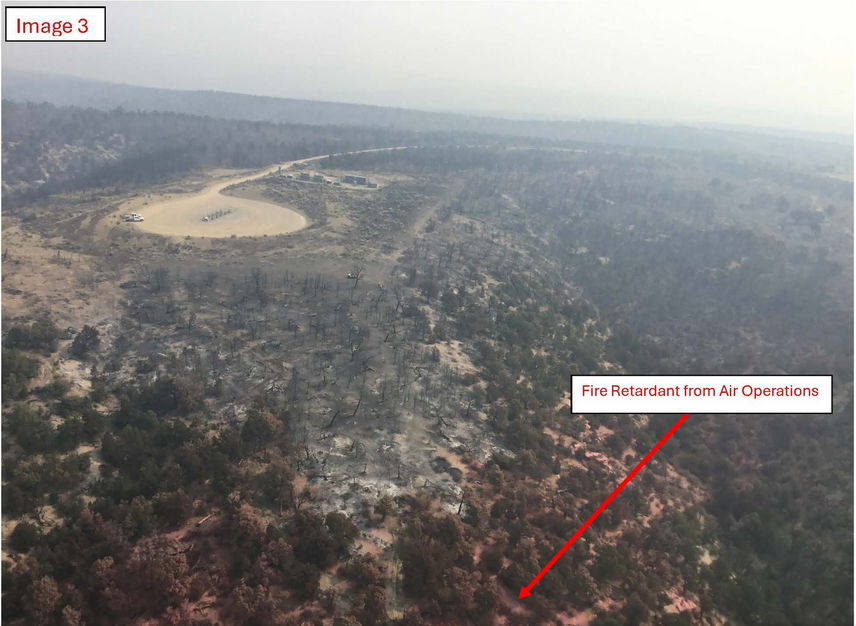
Image 3: This image, taken on August 14, 2025, shows how the Lee Fire burned around the oil and gas infrastructure and minimized the impacts to operations. Some critical values at risk, such as oil and gas infrastructure, have buffer requirements for vegetation for reducing wildfire risk. The lower half of this photo illustrates use of fire retardant during suppression efforts.
Image 4: This image, taken on August 14, 2025, is looking south of Highway 64, just west of the Town of Meeker. On August 6, 2025, when the Lee Fire crossed Highway 13 and progressed towards Meeker, firefighters protected critical values at risk, such as private properties, as seen in this image of the burned area on the northeast edge of the fire.
Size: Elk Fire: 14,518 acres | Lee Fire: 133,954 acres Total Personnel: 1,230 Containment: Elk Fire: 93% | Lee Fire 31% Cause: Lightning Resources: 9 Aircraft | 27 Hand Crews | 82 Engines | 46 Heavy Equipment
Special Announcement: A community meeting for the Lee and Elk fires will be held tonight at 7:00 P.M. at the Meeker High School, 550 School St, in Meeker, Colorado.
Important Notes: The Rio Blanco County Sheriff’s Office downgraded several evacuation zones from GO (red) to SET (yellow) and from SET to READY (green). The Garfield County Sheriff’s Office downgraded Zone 70 on the east side of Highway 13 in northern Garfield County from GO (red) to SET (yellow). Other zones have not changed. Check your evacuation zone on the interactive map: http://bit.ly/lee-fire-zones. Yesterday: Lee Fire – Firefighters made progress, increasing containment to 31% along the Highway 13 corridor. Crews remained engaged on the southern portion of Highway 13. Work continued near Hogback Ridge, where firefighters patrolled and reinforced lines around structures and areas around County Road 5, and other values at risk. Unmanned Aircraft Systems (UAS) were used across the fire to detect isolated areas of heat. Vegetation burned slowly inside the fire perimeter near County Road 5 and County Road 3, removing unburned fuel pockets and supporting control efforts.
Elk Fire: Crews focused on unburned fuels inside the north and west edges of the fire perimeter to strengthen containment. Suppression repair continued to restore hand and dozer lines to a more natural condition.
Current Situation: Rain fell over both fires last night ranging from .05”– 0.1” of an inch and helped to moderate fire behavior. The increase in moisture and humidity will help firefighters as they continue to suppress the fire.
Lee Fire – Crews are holding and reinforcing control lines. On the north side, firefighters continue to monitor, patrol, and reinforce lines. Firefighters are working along Highway 13 using saws, chippers, and heavy equipment to remove hazards. The southern edge remains most active, with crews improving containment lines to limit the potential for fire to spread outside of the perimeter. Firefighters will continue to patrol and protect structures and other values at risk.
Elk Fire: Firefighters will continue to reinforce containment line, patrol and mop up hotspots, while coordinating suppression repair plans with landowners and managers. Crews are also focused on the remaining uncontained section of the fire, with resources in place to prepare for transition to local units. Work continues on preparing contingency lines. These secondary lines will provide firefighters the opportunity to hold the fire with the highest probability of success if extreme conditions occur and push the fire outside existing containment lines.
Weather & Fire Behavior: A morning temperature inversion may bring fog and high humidity, with a chance of isolated showers during the day. Temperatures will reach the low 80s with west/northwest winds. Fuel moisture remains low, and significant precipitation would be needed to return levels to normal. Conditions will dry into the evening and a drying trend is expected to continue through mid-week, with a potential return of monsoonal conditions later in the week.
Evacuations and Closures: CR 5 and Hwy 13 remain closed. For the most up-to-date road closure information, please visit www.COtrip.org or use the COtrip app. To sign up for Garfield County Emergency Alerts, go to: https://garco911.com/. For Garfield County updates go to: https://www.garfieldcounty.net/. Go to the Rio Blanco County Sheriff’s Office Facebook page – https://www.facebook.com/
Rio Blanco County Sheriffs Office – for accurate up-to-date information on all evacuations and road closures. Sign up for emergency alerts at: https://rioblancoalerts.genasys.com/portal/en. White River National Forest closure information at: https://www.fs.usda.gov/r02/whiteriver/alerts. BLM White River Field Office closures information at: https://ow.ly/78uF50WGjNW.
Elk and Lee Fire Information: Phone: 970-341-8665; Email: 2025.elkrbx@firenet.gov Facebook: www.facebook.com/elkleefire Inciweb Lee Fire: https://inciweb.wildfire.gov/incident-information/cowrd-lee-fire Inciweb Elk Fire: https://inceb.wildfire.gov/incident-infrmation/cowrd-elk-rbx-fire
Recursos: 9 aviones | 27 cuadrillas | 82 camiones de bomberos | 46 maquinaria pesada Anuncio especial: Esta noche a las 7:00 p.m. se llevará a cabo una reunión comunitaria por los incendios de Lee y Elk en la Escuela Secundaria Meeker, 550 School St, en Meeker, Colorado. Notas importantes: La Oficina del Sheriff del Condado de Río Blanco degradó varias zonas de evacuación de GO (rojo) a SET (amarillo) y de SET a READY (verde). La Oficina del Sheriff del Condado de Garfield degradó la Zona 70 en el lado este de la autopista 13 en el norte del condado de Garfield de GO (rojo) a SET (amarillo). Otras zonas no han cambiado. Verifique su zona de evacuación en el mapa interactivo: http://bit.ly/lee-fire-zones.
Ayer: Incendio Lee – Los bomberos avanzaron, aumentando la contención al 31% a lo largo del corredor de la autopista 13. Las cuadrillas permanecieron comprometidas en la parte sur de la autopista 13. El trabajo continuó cerca de Hogback Ridge, donde los bomberos patrullaron y reforzaron las líneas alrededor de las estructuras y áreas alrededor de County Road 5, y otros valores en riesgo. Se utilizaron sistemas de aeronaves no tripuladas (UAS por sus siglas en ingles pero conocidos como drone) en todo el incendio para detectar áreas aisladas de calor. La vegetación se quemó lentamente dentro del perímetro del incendio cerca de County Road 5 y County Road 3, eliminando bolsas de combustible no quemado y apoyando los esfuerzos de control. Incendio Elk – Las cuadrillas se centraron en los combustibles no quemados dentro de los bordes norte y oeste del perímetro del incendio para fortalecer la contención. La reparación de supresión continuó restaurando las líneas de mano y topadora a una condición más natural.
Situación actual: La lluvia cayó sobre ambos incendios anoche entre .05 “y 0.1” de pulgada y ayudó a moderar el comportamiento del fuego. El aumento de la humedad ayudará a los bomberos a medida que continúan sofocando el fuego.
Incendio Lee – Las cuadrillas están manteniendo y reforzando las líneas de control. En el lado norte, los bomberos continúan monitoreando, patrullando y reforzando las líneas. Los bomberos están trabajando a lo largo de la autopista 13 utilizando sierras, astilladoras y equipo pesado para eliminar los peligros. El borde sur sigue siendo el más activo, con equipos que mejoran las líneas de contención para limitar la posibilidad de que el fuego se propague fuera del perímetro. Los bomberos continuarán patrullando y protegiendo estructuras y otros valores en riesgo.
Incendio Elk – Los bomberos continuarán reforzando la línea de contención, patrullando y limpiando los puntos críticos, mientras coordinan los planes de reparación de supresión con los propietarios y administradores. Las cuadrillas también se centran en la sección restante del incendio, con recursos para prepararse para la transición a las unidades locales. Se sigue trabajando en la preparación de líneas de contingencia. Estas líneas secundarias brindarán a los bomberos la oportunidad de contener el fuego con la mayor probabilidad de éxito si ocurren condiciones extremas y empujan el fuego fuera de las líneas de contención existentes.
Comportamiento del clima y el fuego: Una inversión de temperatura matutina puede traer niebla y alta humedad, con la posibilidad de lluvias aisladas durante el día. Las temperaturas alcanzarán los 80 grados bajos con vientos del oeste / noroeste. La humedad del combustible sigue siendo baja y se necesitarían precipitaciones significativas para que los niveles vuelvan a la normalidad. Las condiciones se secarán hasta la noche y se espera que continúe una tendencia de secado hasta mediados de semana, con un posible regreso de las condiciones monzónicas más adelante en la semana.
Evacuaciones y cierres: CR 5 y Hwy 13 permanecen cerradas. Para obtener la información más actualizada sobre el cierre de carreteras, visite http://www.COtrip.org o utilice la aplicación COtrip. Para inscribirse en las alertas de emergencia del condado de Garfield, visite: https://garco911.com/. Para obtener actualizaciones del condado de Garfield, visite: https://www.garfieldcounty.net/. Vaya a la página de Facebook de la Oficina del Sheriff del Condado de Río Blanco – https://www.facebook.com/RioBlancoCountySheriffsOffice – para obtener información precisa y actualizada sobre todas las evacuaciones y cierres de carreteras. Regístrese para recibir alertas de emergencia en: https://rioblancoalerts.genasys.com/portal/en. Información sobre el cierre del Bosque Nacional White River en: https://www.fs.usda.gov/r02/whiteriver/alerts. Información sobre los cierres de la oficina de campo de BLM White River en: https://ow.ly/78uF50WGjNW.
Información sobre los incendios de Elk y Lee: Teléfono: 970-341-8665; Correo electrónico: 2025.elkrbx@firenet.gov Facebook: www.facebook.com/elkleefire Iniciweb Incendio Lee: https://inciweb.wildfire.gov/incident-information/cowrd-lee-fire Inciweb Incendio Elk: https://inciweb.wildfire.gov/incident-information/cowrd-elk-rbx-fire
8.16.25, 7:29 a.m. – Good morning from the Elk and Lee Fires, where conditions are pleasantly damp this morning. The fires received between .05 and .1 inches of rain last night. Skies are expected to clear this morning and firefighters will take advantage of wetter conditions to mop up, patrol, and secure firelines. Warmer, drier weather conditions are expected over the next few days.
Firefighters made steady progress today on containment efforts across both fires, including work on contingency lines. The Elk Fire resources focused on final containment and support to local units. On the Lee Fire, crews continued to secure areas along Highway 13 and worked across the fire to reinforce lines and address interior heat.
Weather today brought higher humidity, which helped moderate fire activity. Conditions are expected to dry out over the next several days, with the potential for thunderstorms returning next week.
August 15, 2025, 3:45 p.m. – Firelines are holding on both the Lee and Elk fires this afternoon. Crews are mopping up to secure these lines and put out any hot spots. Firefighters are also focusing mop up efforts around structures and other values at risk. Prep work is continuing on contingency lines on the south edge of the fire.