Northern Rockies Complex Incident Management Team 3
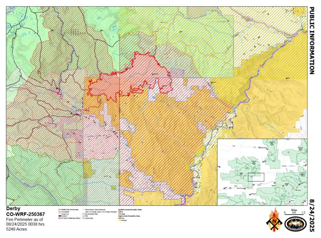
As of late afternoon on Sunday, August 24, 2025, the Derby Fire is 5,346 acres in size, with 0% containment and 648 personnel. Firefighters were able to conduct a successful burnout operation in the Horse Creek Drainage on the southern side of the fire before the afternoon rain. Line construction continued along the southwest and southeast edges of the fire.
Firefighters had strong support from aerial resources today, working with both retardant and water drops. Two military modular air firefighting systems (MAFFs) and supporting personnel arrived to assist with retardant drops. Aircraft aiding firefighting operations included four single-engine airtankers (SEATs), one large air tanker (LAT), two heavy helicopters, and a helicopter flying reconnaissance missions which also retrieved firefighters dropped off to tackle spot fires. When many aircraft are flying, in-air coordination is needed! Two air attack planes coordinated retardant and water bucket drops, a lead plane guided the large tankers and two Type 3 helicopters acted as communications repeaters.
The fire received widespread rain with heavier amounts in some areas. However, rain may not have penetrated denser tree canopies.
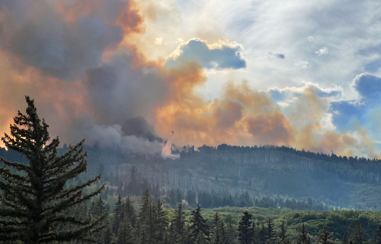
The photo below was taken late afternoon on Saturday, August 23, where the southeast edge of the fire grew. Look closely to see a helicopter dropping water along the fire edge. Photo by NIki Carpenter/Derby Fire.
Northern Rockies Complex Incident Management Team 3
Incident meteorologist, Ryan Fliehman, discusses the environmental conditions that have driven recent fire growth, as well as the weather outlook for the next few days. Thunderstorms forming to the north and west of the fire have created gusty, persistent, outflow winds that flow over the face of the fire and push it downslope into the canyons. In the evening and nighttime hours, diurnal winds that occur as cool air sinks have also pushed the fire. We are expecting storms this afternoon, which will increase wind activity in the canyons, but will increase the chance of rainfall today. More meaningful precipitation levels are expected into this week.
The Derby Fire grew in the late afternoon into the night on Saturday, August 23, on the southeast flank of the fire, as winds pushed the fire southeast. Secondary contingency lines are in place. Firefighters will be assessing the fire edge in that area and looking for opportunities to engage with handcrews, dozers, and aerial retardant drops. Thunderstorms moving through the area this afternoon could inhibit operations.
Firefighters are working on structure protection along Red Dirt Creek Road. Hotshots and handcrews are working to construct handline on the eastern side of the fire.
Firefighters have prepped more than 500 structures in the Sweetwater drainage corridor, with work continuing today. Hotshot crews have constructed direct fireline to the Hack Creek drainage on the southwest flank. They will continue to work along the southwest to west flank of the fire and will work north as terrain and weather conditions allow. On the southern side of the fire, burnout operations on Saturday August 23 were successful in removing unburned fuel from between the fire edge and the constructed fireline. If the weather allows, burnout operations will continue on that south edge. Burnout operations reduce the potential for fire spotting into unburned areas, and reduce the intensity of the fire along the fireline.
Northern Rockies Complex Incident Management Team 3 Incident Commander Mike Behrens
Location: 13 miles north of Dotsero, CO Start date: 8/16/2025 Cause: Lightning Size: Est. 5248 acres Completion/Containment: 0% 525 total personnel
Key Message:
Firefighters are working to build and strengthen control lines along the Derby Fire’s west, south, and east perimeters. Aircraft supported ground operations by dropping water and flame retardant on the east and west flanks. The Colorado River Rd. closure has been extended south, closing access to Coffeepot Road.
Current Status:
The east side of the Derby Fire was more active on Saturday, and three aircraft dropped water and flame retardant to slow its spread down the slopes of its southeast flank. The fire is growing slowly on other parts of its south perimeter, where firefighters are constructing control lines from a network of roads, dozer line, and hand line. On Saturday they worked to strengthen and widen those fire lines and plan to continue on Sunday if weather and conditions permit. Other crews have protected over 500 structures by positioning sprinkler kits and removing surrounding fuels. The White River National Forest has expanded their closure order to include the area southwest of Sweetwater Lake to the west rim of Deep Creek Canyon. The Colorado River Rd. closure has been extended south, from the Dotsero roundabout’s north side to Red Dirt Rd. Note that Coffeepot Rd. cannot be accessed from its intersection with Colorado River Rd.
Weather and Fire Behavior:
Outflow winds have begun to push the Derby Fire south, but there is a good chance of wetting rain on Sunday. Rainfall may also be accompanied by some lightning. Daytime smoke and nighttime fire glows may be visible.
Closures and Special Messages:
Eagle County has issued an evacuation notice for residents of Sweetwater Rd. and Red Dirt Creek. Zones GYF-263, 266-A, 267, 300, 366, and 369 are in pre-evacuation status. More evacuation information is available at www.ecemergency.org, including where to shelter and resources for pets and livestock.
Equipo 3 de Gestión de Incidentes del Complejo de las Montañas Rocosas del Norte Comandante de Incidentes Mike Behrens Ubicación: 13 millas al oeste de Dotsero, CO Fecha de inicio: 08/16/2025; Causa: Rayo Tamaño: Est. 5248 acres Finalización/Contención: 0% – 525 Personal total
Mensaje clave:
Los bomberos están trabajando para construir y fortalecer las líneas de control a lo largo de los perímetros oeste, sur y este del incendio de Derby. Los aviones apoyaron las operaciones terrestres lanzando agua y retardantes de llama en los flancos este y oeste. El cierre de Colorado River Rd. se ha extendido hacia el sur, cerrando el acceso a Coffeepot Rd.
Estado actual:
El lado este del incendio Derby estaba más activo el sábado, y tres aviones arrojaron agua y retardante para frenar su propagación por las laderas de su flanco sureste. El incendio está creciendo lentamente en otras partes de su perímetro sur, donde los bomberos están construyendo líneas de control a partir de una red de carreteras, línea de topadoras y línea de mano. El sábado trabajaron para fortalecer y ampliar esas líneas de fuego y planean continuar el domingo si el clima y las condiciones lo permiten. Otras cuadrillas han protegido más de 500 estructuras colocando kits de rociadores y retirando los combustibles circundantes. El Bosque Nacional White River ha ampliado su orden de cierre para incluir el área al suroeste del lago Sweetwater hasta el borde oeste de Deep Creek Canyon. El cierre de Colorado River Rd. se ha extendido hacia el sur, desde el lado norte de la rotonda de Dotsero hasta Red Dirt Rd. Tenga en cuenta que no se puede acceder a Coffeepot Rd. desde su intersección con Colorado River Rd.
Comportamiento del clima y el fuego
Los vientos de salida han comenzado a empujar el incendio Derby hacia el sur, pero hay una buena posibilidad de lluvia húmeda el domingo. Las lluvias también pueden ir acompañadas de algunos rayos. El humo diurno y los resplandores nocturnos del fuego pueden ser visibles.
Cierres y mensajes especiales
El condado de Eagle ha emitido un aviso de evacuación para los residentes de Sweetwater Rd. y Red Dirt Creek. Las zonas GYF-263, 266-A, 267, 300, 366 y 369 están en estado previo a la evacuación. Hay más información sobre evacuación disponible en www.ecemergency.org, incluido dónde refugiarse y recursos para mascotas y ganado.
El Servicio Forestal y BLM han emitido órdenes de cierre público en las cercanías del incendio para proteger la seguridad pública y de los bomberos. La orden de cierre y el mapa del Bosque Nacional White River están publicados en https://www.fs.usda.gov/r02/whiteriver. La orden de cierre y el mapa de la Oficina de Campo del Valle del Río Colorado de BLM se publican en https://www.blm.gov/announcement/blm-issues-land-closure-garfield-and-eagle-counties-firefighting-activities. Además, existe una restricción temporal de vuelo (TFR por sus siglas en inglés) sobre el incendio de Derby. Todas las aeronaves no autorizadas (incluidos los drones) tienen prohibido volar cerca del incendio, ya que pueden interferir con las operaciones de apoyo aéreo autorizadas. Para obtener más información, visite www.tfr.faa.gov.
Northern Rockies Complex Incident Management Team 3
Updated 8/24/25, 8:00 am – Good morning, all, the updated acreage here reflects information recieved from an infrared flight flown last night, which was not yet available at our time of posting this morning. Personnel numbers and containment percentages remain the same.
Derby Fire quick facts: August 24, 2025 Total acreage: 5,248 acres 0% containment 525 personnel/resources #DerbyFire#FireYear2025
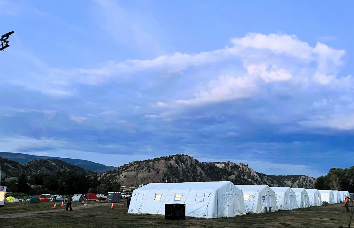
Morning sunlight rises over the tents at the Derby Fire Incident Command Post near Eagle, CO. Mobile incident command posts often use yurts or tents as workspace for the units involved in managing incidents. Photo by Northern Rockies Complex Incident Management Team 3.
Northern Rockies Complex Incident Management Team 3
#DerbyFire Ops Update Saturday afternoon, Aug. 23, 2025
Operations Section Chief, Philip Knaub, provides an overview of firefighting tactics.
Derby Fire: No significant growth overnight and less active today
There was no significant growth on the Derby Fire north of Dotsero, CO overnight. Night operations focused on structure protection in the Sweetwater Canyon area. The fire has been less active today.
Hotshot crews are working to construct and improve fireline directly adjacent to the fire’s edge along the southwest side. Conditions this afternoon have allowed firefighters to conduct a burnout operation on the southern edge of the fire, as discussed in the video here. Smoke may be more visible during the operation. Air resources are on hand for support.
Structure protection and assessment efforts are ongoing. Handcrews and heavy equipment will continue to build and improve control lines, supported by air resources as weather conditions allow.
Northern Rockies Complex Incident Management Team 3
#DerbyFire Ops Update Friday afternoon, Aug. 22, 2025
Firefighters supported by air tankers dropping retardant and helicopters with water dropping buckets are focusing on the southwest and southern portions of the fire. Tactical fireing operations are removing burnable vegetation between constructed control lines and the fire’s edge. This work is being done to slow the fire’s progress and will continue into the night shift if the weather, fuel and fire conditions allow.
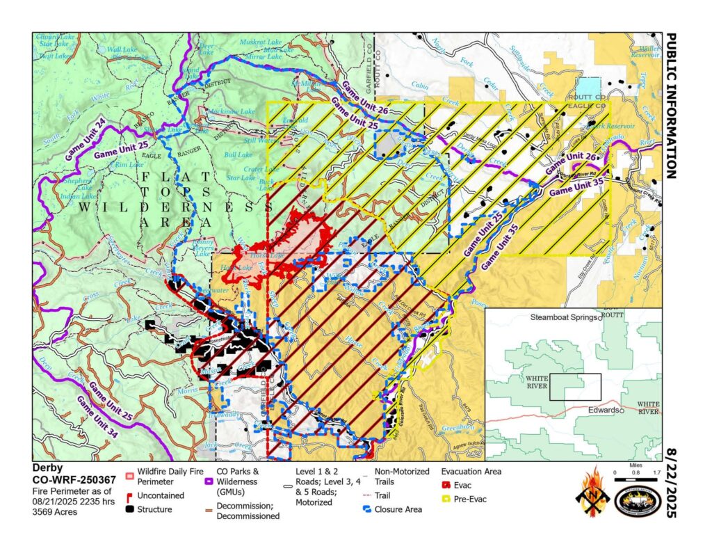
Location: 13 miles north of Dotsero, CO Start Date: 8/16/2025; Cause: Lightning Size: Est. 3569 acres Completion/Containment: 0% 211 total personnel
PUBLIC MEETING TONIGHT – 630pm Gypsum Town Hall, 50 Lundgren Blvd.
Key Message:
Aircraft dropped water and fire retardant along the Derby Fire’s western flank. Firefighters built dozer lines along the fire’s southern perimeter, then worked overnight to secure it. Structure protection on over 200 structures has been completed.
Current Status:
The fire is expanding slowly because it is mostly driven by fuels and not wind. Fire managers are being vigilant in their preparations for thunderstorm outflow winds that could push fire south into the Sweetwater Creek drainage. Fire managers have already worked to complete structure protection for over 200 structures along Sweetwater Rd. to Red Dirt Creek by positioning sprinkler kits and removing surrounding fuels. Yesterday firefighters established dozer lines along the fire’s southern perimeter, then worked to secure it overnight. Aircraft supported ground crews by dropping water and fire retardant along the fire’s west flank to slow its expansion toward Sweetwater Rd., buying time for firefighters to secure and connect containment lines.
Weather and Fire Behavior:
The trend of hot and dry weather continues to make subalpine fuels very receptive to fire spread. However, the weekend is likely to bring cooler temperatures and increased chances of monsoonal precipitation. Daytime smoke and nighttime glows from the fire may be visible.
Closures and Special Messages:
Eagle County has issued an evacuation notice for residents of Sweetwater Rd. and areas of the Colorado River Rd. from Sweetwater to Red Dirt Creek. Derby Mesa Loop remains in pre-evacuation status. More evacuation information is available at www.ecemergency.org, including where to shelter and resources for pets and livestock.
The Forest Service and BLM have both issued public closure orders in the vicinity of the fire to protect public and firefighter safety. The White River National Forest’s closure order and map are posted at https://www.fs.usda.gov/r02/whiteriver. The BLM Colorado River Valley Field Office’s closure order and map are posted at https://www.blm.gov/…/blm-issues-land-closure-garfield….
Ubicación: 13 millas al norte de Dotsero, CO Fecha de inicio: 16/8/2025; Causa: Rayo Tamaño: Est. 3569 acres Finalización/Contención: 0% 211 efectivos en total
REUNIÓN PÚBLICA ESTA NOCHE – 6:30 pm Ayuntamiento de Gypsum, 50 Lundgren Blvd.
Mensaje clave:
Aviones lanzaron agua y retardante de fuego a lo largo del flanco oeste del incendio Derby. Los bomberos construyeron líneas de excavadoras a lo largo del perímetro sur del incendio y trabajaron durante la noche para asegurarlo. Se completó la protección de más de 200 estructuras.
Estado actual:
El incendio se está expandiendo lentamente debido a que es impulsado principalmente por combustibles y no por el viento. Los bomberos se mantienen alertas en sus preparativos ante los vientos de salida de tormenta que podrían empujar el fuego hacia el sur, hacia la cuenca del arroyo Sweetwater. Los bomberos ya han completado la protección de más de 200 estructuras a lo largo de Sweetwater Rd. hasta Red Dirt Creek, instalando equipos de rociadores y retirando los combustibles circundantes. Ayer, los bomberos establecieron líneas de excavadoras a lo largo del perímetro sur del incendio y trabajaron para asegurarlo durante la noche. Aeronaves apoyaron a los equipos de tierra lanzando agua y retardante de fuego a lo largo del flanco oeste del incendio para frenar su expansión hacia Sweetwater Rd., lo que les dio tiempo a los bomberos para asegurar y conectar las líneas de contención.
El clima y el comportamiento del fuego:
La tendencia al clima cálido y seco continúa haciendo que los combustibles subalpinos sean muy susceptibles a la propagación del fuego. Sin embargo, es probable que el fin de semana traiga temperaturas más bajas y mayores probabilidades de precipitaciones monzónicas. Es posible que se observe humo diurno y resplandores nocturnos del incendio.
Cierres y mensajes especiales:
El Condado de Eagle ha emitido un aviso de evacuación para los residentes de Sweetwater Rd. y áreas de Colorado River Rd. desde Sweetwater hasta Red Dirt Creek. Derby Mesa Loop permanece en estado de preevacuación. Puede encontrar más información sobre la evacuación en www.ecemergency.org , incluyendo dónde refugiarse y recursos para mascotas y ganado.
El Servicio Forestal y la Oficina de Administración de Tierras (BLM) han emitido órdenes de cierre público en las inmediaciones del incendio para proteger la seguridad del público y de los bomberos. La orden de cierre y el mapa del Bosque Nacional del Río Blanco están publicados en https://www.fs.usda.gov/r02/whiteriver . La orden de cierre y el mapa de la Oficina de Campo del Valle del Río Colorado de la BLM están publicados en https://www.blm.gov/…/blm-issues-land-closure-garfield… .