News Release Update: 1.13.26- High-risk traffic stop turns manhunt following officer-involved shooting near Dotsero
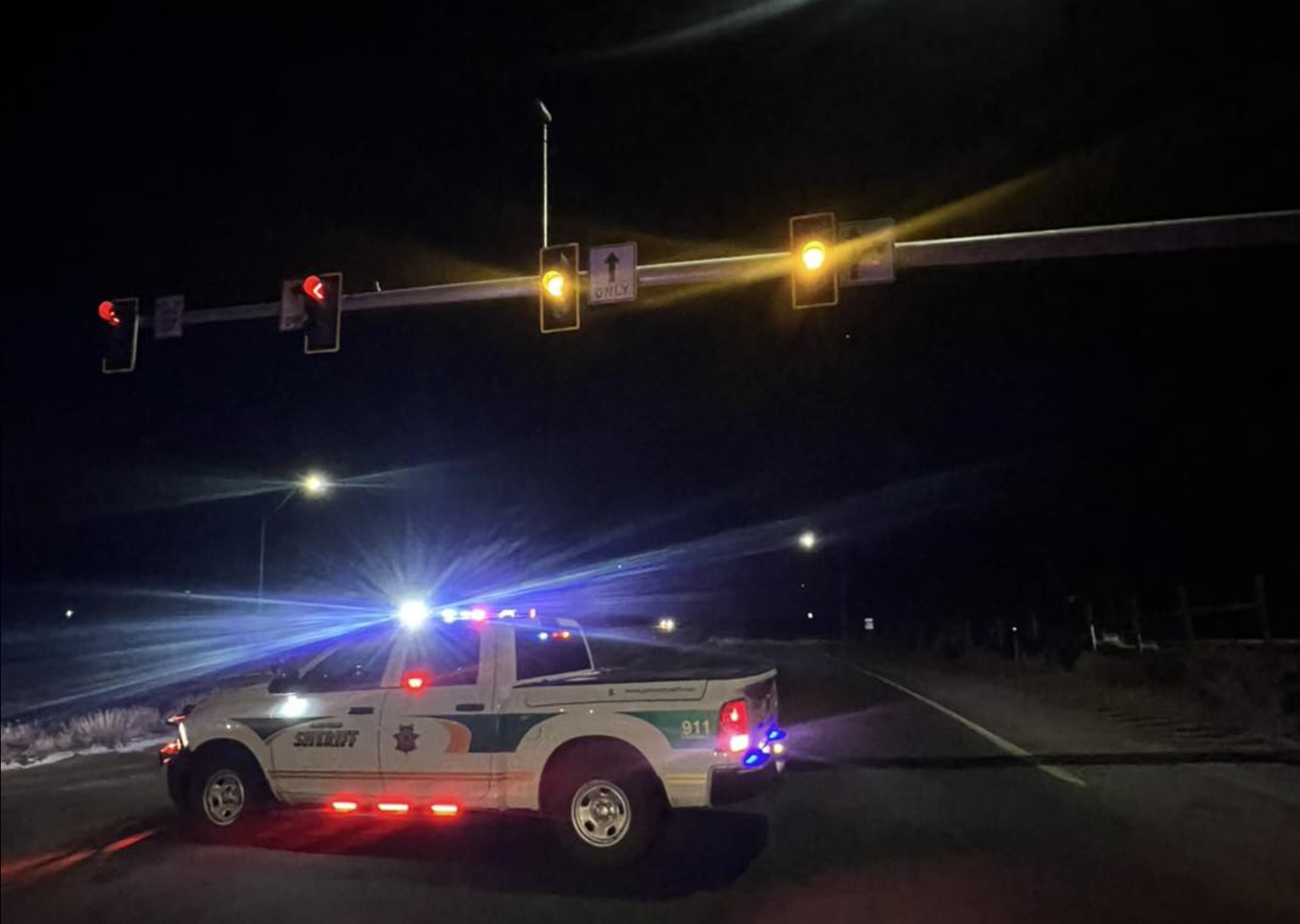
Eagle County, Colo.- The shelter in place remains ongoing for the Dotsero area as a precaution. I-70 westbound is still closed at mile marker 133, and I-70 eastbound is closed at mile marker 119. Our crews continue working diligently towards reopening the roadway when it is safe to do so. We will have a brief update for the media at 1 pm in the B lot of the Eagle County Sheriff’s Office, 955 Chambers Avenue. Media Personnel, please follow the signs to the staging area. Sheriff Van Beek and our partners will provide an update on the investigation and suspect information.
Actualización del Comunicado de Noticias: 1.13.26. Una parada de tráfico de alto riesgo se convierte en una persecución tras un tiroteo con participación policial cerca de Dotsero
Condado de Eagle, Colorado. Como medida de precaución, se mantiene la orden de permanecer en casa en la zona de Dotsero. La I-70 en dirección oeste sigue cerrada en el marcador de milla 133, y la I-70 en dirección este está cerrada en el marcador de milla 119. Nuestros equipos siguen trabajando diligentemente para reabrir la carretera cuando sea seguro hacerlo. Ofreceremos una breve actualización para los medios de comunicación a la 1 p. m. en el estacionamiento B de la Oficina del Alguacil del Condado de Eagle, 955 Chambers Avenue. Los medios de comunicación deben seguir las señales hasta la zona de reunión. El Alguacil Van Beek y nuestros socios proporcionarán información actualizada sobre la investigación y el sospechoso.
News Release: 1.13.26 – High-risk traffic stop turns manhunt following officer-involved shooting near Dotsero
DOTSERO, Colo. – Just after 4:00 am on Jan. 13, 2026, Vail Public Safety Communications received information to be on the lookout for a homicide suspect out of the Denver area who was believed to be traveling near Gypsum. The suspect was reported to be armed and possibly accompanied by hostages.
Preliminary information indicates that a deputy with the Eagle County Sheriff’s Office located a vehicle that matched the description, driving westbound on 1-70 at a high rate of speed, and began pursuing it. After observing the vehicle exit at mile marker 119 and get back on I-70 eastbound, deputies attempted to initiate a traffic stop.
Since the suspect refused to stop, deputies deployed a spike strip successfully near mile marker 130 on I-70.
Two parties then exited the vehicle, pointing a firearm at law enforcement, and shots were exchanged between the suspect(s) and law enforcement. One party was injured in the exchange and received medical care on scene before being transported to a hospital. The remaining people in the vehicle were then contacted by law enforcement.
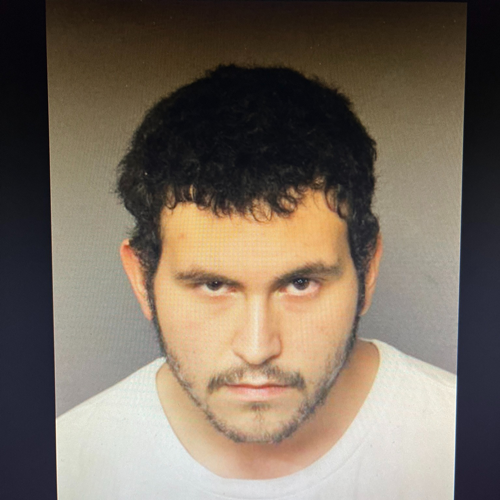
There is still an active scene at this time with a manhunt and shooting investigation. Deputies with Eagle County Sheriff’s Office and the Garfield County Sheriff’s Office, along with Colorado State Patrol and the Special Operations Unit, are still searching for the suspect who fled, pictured below. He is believed to be armed and dangerous. If you see him, do not approach and call 911.
As a precaution, a shelter-in-place order has been issued for the surrounding areas. I-70 is also shut down at mile marker 140 in Gypsum and Eastbound at mile marker 119 at the Glenwood Canyon Rest area.
Community members are asked to avoid the area, follow all directions from law enforcement, refrain from stopping for hitchhikers, and keep a safe distance from the scene.
This is an ongoing situation; the Colorado Bureau of Investigation (CBI) has been requested, and updates will be provided when possible.
_____________________________________
Comunicado de Noticias: 1.13.26. Una parada de tráfico de alto riesgo se convierte en una persecución tras un tiroteo con un oficial cerca de Dotsero.
DOTSERO, Colorado. -Poco después de las 4:00 a. m. del 13 de enero de 2026, el Centro de Comunicaciones de Seguridad Pública de Vail recibió información para estar atento a un sospechoso de homicidio de la zona de Denver que se creía que estaba viajando cerca de Gypsum. Se informó de que el sospechoso estaba armado y posiblemente acompañado de rehenes.
La información preliminar indica que un oficial de la Oficina del Alguacil del Condado de Eagle localizó un vehículo que coincidía con la descripción, que circulaba en dirección oeste por la I-70 a gran velocidad, y comenzó a perseguirlo. Tras observar que el vehículo salía en el marcador de milla 119 y volvía a incorporarse a la I-70 en dirección este, los oficiales intentaron detenerlo.
Dado que el sospechoso se negó a detenerse, los agentes desplegaron con éxito una banda de clavos cerca del marcador de milla 130 de la I-70.
A continuación, dos personas salieron del vehículo, apuntando con un arma de fuego al oficial, y se produjo un intercambio de disparos entre el sospechoso o sospechosos y la fuerza policial. Una de las personas resultó herida en el intercambio y recibió atención médica en el lugar antes de ser trasladada a un hospital. Las fuerzas policiales se pusieron en contacto con las demás personas que se encontraban en el vehículo.
En estos momentos, la escena sigue activa, con una búsqueda del sospechoso y una investigación del tiroteo. Oficiales de la Oficina del Alguacil del Condado de Eagle y de la Oficina del Alguacil del Condado de Garfield, junto con la Patrulla Estatal de Colorado y la Unidad de Operaciones Especiales, siguen buscando al sospechoso que huyó, cuya foto se muestra a continuación. Se cree que está armado y es peligroso. Si lo ve, no se acerque y llame al 911.
Como medida de precaución, se ha emitido una orden de refugio en el lugar para las áreas circundantes. La I-70 también está cerrada en el marcador de milla 140 en Gypsum y en dirección este en el marcador de milla 119 en el área de descanso de Glenwood Canyon.
Se pide a los miembros de la comunidad que eviten la zona, sigan todas las instrucciones de las fuerzas policiales, se abstengan de parar a los transeúntes y mantengan una distancia segura de la escena.
Se trata de una situación en curso; se ha solicitado la intervención de la Oficina de Investigación de Colorado (CBI) y se proporcionará información actualizada cuando sea posible.
1.13.26, 4:40 a.m. – CORRECTION: I-70 is closed eastbound at the mile marker 119, No Name Rest Area.
1.13.26, 4:27 a.m. – UPDATE: Eastbound is now closed at the mile marker 116, Glenwood Springs. It is also closed westbound at the Gypsum exit in Eagle County.
Garfield County Emergency Communications Authority
1.13.26, 4:19 a.m. – I-70 is closed at mile marker 125 eastbound, Hanging Lake, due to police activity.
December 2, 2025, 11:15 a.m. – I-70 is now open at mile marker 105, New Castle.
December 2, 2025, 9:27 a.m. – Eastbound Interstate 70 is closed at mile marker 105, just before the New Castle exit, due to an accident. Traffic is being diverted at Silt.