Structure protection and assessment efforts are ongoing. Handcrews and heavy equipment will continue to build and improve control lines, supported by air resources as weather conditions allow.
Issued for southeastern Dolores and northeastern Montezuma Counties Issued at 6:46 AM MDT, Saturday, August 23, 2025
Issued by the Colorado Department of Public Health and Environment
Affected Area: Southeastern Dolores and northeastern Montezuma Counties. Locations include, but are not limited to Stoner.
Advisory in Effect: 9:00 AM MDT, Saturday, August 23, 2025 to 9:00 AM MDT, Sunday, August 24, 2025
Public Health Recommendations: If smoke is thick or becomes thick in your neighborhood you may want to remain indoors. This is especially true for those with heart disease, respiratory illnesses, the very young, and older adults. Consider limiting outdoor activity when moderate to heavy smoke is present. Consider relocating temporarily if smoke is present indoors and is making you ill. If visibility is less than 5 miles in smoke in your neighborhood, smoke has reached levels that are unhealthy.
Outlook: Locations near the Stoner Mesa Fire, including Highway 145 and the Stoner area, are experiencing heavy smoke. Smoke is expected to continue through Sunday morning, especially during the overnight and early morning hours.
Aug. 22, 2025 – An aircraft incident involving a helicopter assigned to the Derby Fire occurred today at 4:10 p.m.
There is an unconfirmed report that the aircraft is in a lake 13 miles northwest of the Eagle County Regional Airport. The pilot was picked up by another incident aircraft and flown to Eagle County Regional Airport. Local emergency medical personnel checked the pilot, who had minor bumps and bruises and desired no further medical attention.
The National Transportation Safety Board has been notified; it is unknown whether they will respond to the incident. A USDA Forest Service investigation team is enroute.
No further information will be released at this time.
Northern Rockies Complex Incident Management Team 3
#DerbyFire Ops Update Friday afternoon, Aug. 22, 2025
Firefighters supported by air tankers dropping retardant and helicopters with water dropping buckets are focusing on the southwest and southern portions of the fire. Tactical fireing operations are removing burnable vegetation between constructed control lines and the fire’s edge. This work is being done to slow the fire’s progress and will continue into the night shift if the weather, fuel and fire conditions allow.
Colorado River Road closure for the Derby Fire has been extended south, starting from the north side of the Dotsero roundabout to Red Dirt Rd. This closure is for all non-residents and non-emergency traffic.
While we understand the impact of road closures, safeguarding and the life safety of people is always our highest priority. This precaution allows emergency crews to focus fully on protecting residents and responders in the area.
Out of respect for your safety and the safety of our dedicated first responders, we ask that you avoid the area unless you’re part of the emergency response team. Every moment and movement matters right now.
***EN ESPAÑOL***
El cierre de la carretera Colorado River por el incendio Derby se ha ampliado hacia el sur, desde el lado norte de la glorieta de Dotsero hasta la calle Red Dirt. Este cierre está para todos los que no son residentes y el tráfico que no sea de emergencia.
Aunque entendemos el impacto que tienen los cierres de carreteras, nuestra prioridad siempre es proteger la vida de las personas. Esta precaución permite que los equipos de emergencia se concentren en proteger a los residentes y a los socorristas de la zona.
Por respeto a su seguridad y a la de nuestros dedicados equipos de emergencia, le pedimos que evite la zona a menos que forme parte del equipo de emergencia. En estos momentos, cada momento y cada movimiento cuentan.
BLM Colorado, Upper Colorado District, Colorado River Valley Field Office Media Contact: Heather Marsh, hmarsh@blm.gov, 970-852-9272 Aug. 22, 2025
BLM Colorado rescinds public land closure order for Lee Fire
SILT, Colo. — Today, the Bureau of Land Management rescinded the land closure order for BLM-managed public lands in Garfield County because of the Lee Fire. The rescission is effective immediately because fire and emergency managers have determined the area is safe.
BLM issued the emergency closure Aug. 11 to ensure public and firefighter safety during suppression and contingency efforts. Activity related to the Lee Fire will continue until the fire is controlled. BLM urges the public to use caution in the area.
The public land closure for the Derby Fire, in Garfield and Eagle Counties, is still in effect. Additionally, the BLM Colorado River Valley Field Office and U.S. Forest White River National Forest remain under stage 2 fire restrictions. Information about fire restrictions is available on the BLM Upper Colorado River District Fire Restrictions webpage.
We appreciate your understanding as we prioritize safety and resource integrity during this critical time. For more information, please call the Colorado River Valley Field Office front desk at 970-876-9000. -BLM-
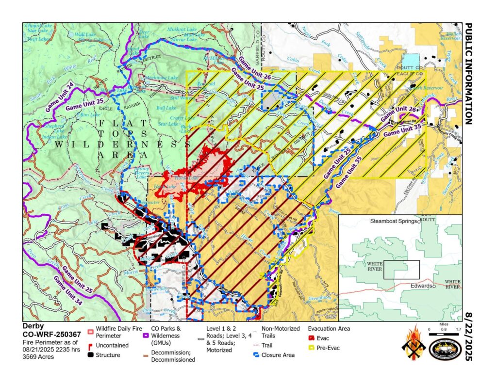
Location: 13 miles north of Dotsero, CO Start Date: 8/16/2025; Cause: Lightning Size: Est. 3569 acres Completion/Containment: 0% 211 total personnel
PUBLIC MEETING TONIGHT – 630pm Gypsum Town Hall, 50 Lundgren Blvd.
Key Message:
Aircraft dropped water and fire retardant along the Derby Fire’s western flank. Firefighters built dozer lines along the fire’s southern perimeter, then worked overnight to secure it. Structure protection on over 200 structures has been completed.
Current Status:
The fire is expanding slowly because it is mostly driven by fuels and not wind. Fire managers are being vigilant in their preparations for thunderstorm outflow winds that could push fire south into the Sweetwater Creek drainage. Fire managers have already worked to complete structure protection for over 200 structures along Sweetwater Rd. to Red Dirt Creek by positioning sprinkler kits and removing surrounding fuels. Yesterday firefighters established dozer lines along the fire’s southern perimeter, then worked to secure it overnight. Aircraft supported ground crews by dropping water and fire retardant along the fire’s west flank to slow its expansion toward Sweetwater Rd., buying time for firefighters to secure and connect containment lines.
Weather and Fire Behavior:
The trend of hot and dry weather continues to make subalpine fuels very receptive to fire spread. However, the weekend is likely to bring cooler temperatures and increased chances of monsoonal precipitation. Daytime smoke and nighttime glows from the fire may be visible.
Closures and Special Messages:
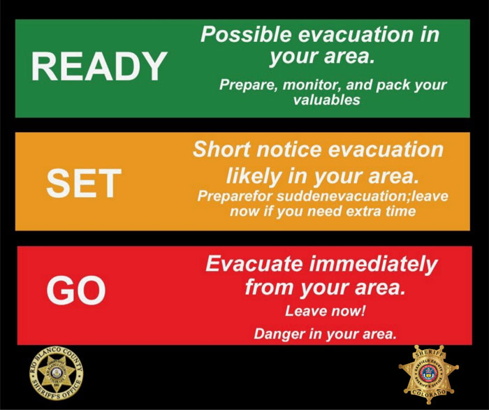
Eagle County has issued an evacuation notice for residents of Sweetwater Rd. and areas of the Colorado River Rd. from Sweetwater to Red Dirt Creek. Derby Mesa Loop remains in pre-evacuation status. More evacuation information is available at www.ecemergency.org, including where to shelter and resources for pets and livestock.
The Forest Service and BLM have both issued public closure orders in the vicinity of the fire to protect public and firefighter safety. The White River National Forest’s closure order and map are posted at https://www.fs.usda.gov/r02/whiteriver. The BLM Colorado River Valley Field Office’s closure order and map are posted at https://www.blm.gov/…/blm-issues-land-closure-garfield….
Ubicación: 13 millas al norte de Dotsero, CO Fecha de inicio: 16/8/2025; Causa: Rayo Tamaño: Est. 3569 acres Finalización/Contención: 0% 211 efectivos en total
REUNIÓN PÚBLICA ESTA NOCHE – 6:30 pm Ayuntamiento de Gypsum, 50 Lundgren Blvd.
Mensaje clave:
Aviones lanzaron agua y retardante de fuego a lo largo del flanco oeste del incendio Derby. Los bomberos construyeron líneas de excavadoras a lo largo del perímetro sur del incendio y trabajaron durante la noche para asegurarlo. Se completó la protección de más de 200 estructuras.
Estado actual:
El incendio se está expandiendo lentamente debido a que es impulsado principalmente por combustibles y no por el viento. Los bomberos se mantienen alertas en sus preparativos ante los vientos de salida de tormenta que podrían empujar el fuego hacia el sur, hacia la cuenca del arroyo Sweetwater. Los bomberos ya han completado la protección de más de 200 estructuras a lo largo de Sweetwater Rd. hasta Red Dirt Creek, instalando equipos de rociadores y retirando los combustibles circundantes. Ayer, los bomberos establecieron líneas de excavadoras a lo largo del perímetro sur del incendio y trabajaron para asegurarlo durante la noche. Aeronaves apoyaron a los equipos de tierra lanzando agua y retardante de fuego a lo largo del flanco oeste del incendio para frenar su expansión hacia Sweetwater Rd., lo que les dio tiempo a los bomberos para asegurar y conectar las líneas de contención.
El clima y el comportamiento del fuego:
La tendencia al clima cálido y seco continúa haciendo que los combustibles subalpinos sean muy susceptibles a la propagación del fuego. Sin embargo, es probable que el fin de semana traiga temperaturas más bajas y mayores probabilidades de precipitaciones monzónicas. Es posible que se observe humo diurno y resplandores nocturnos del incendio.
Cierres y mensajes especiales:
El Condado de Eagle ha emitido un aviso de evacuación para los residentes de Sweetwater Rd. y áreas de Colorado River Rd. desde Sweetwater hasta Red Dirt Creek. Derby Mesa Loop permanece en estado de preevacuación. Puede encontrar más información sobre la evacuación en www.ecemergency.org , incluyendo dónde refugiarse y recursos para mascotas y ganado.
El Servicio Forestal y la Oficina de Administración de Tierras (BLM) han emitido órdenes de cierre público en las inmediaciones del incendio para proteger la seguridad del público y de los bomberos. La orden de cierre y el mapa del Bosque Nacional del Río Blanco están publicados en https://www.fs.usda.gov/r02/whiteriver . La orden de cierre y el mapa de la Oficina de Campo del Valle del Río Colorado de la BLM están publicados en https://www.blm.gov/…/blm-issues-land-closure-garfield… .