Rocky Mountain Area Complex Incident Management Team 3
#DerbyFire Operations Update, Tuesday, Sept. 3, 2025, Ryan Sharpe Operations Section Chief, discusses firefighting tactics on the #DerbyFire.
Containment on the Derby Fire rose to 41%. The main priority today will be focusing efforts in the northwest area outside of the fire perimeter. Operations Section Chief Ryan Sharpe shares the rest of the operations plan.
Rocky Mountain Area Complex Incident Management Team 3
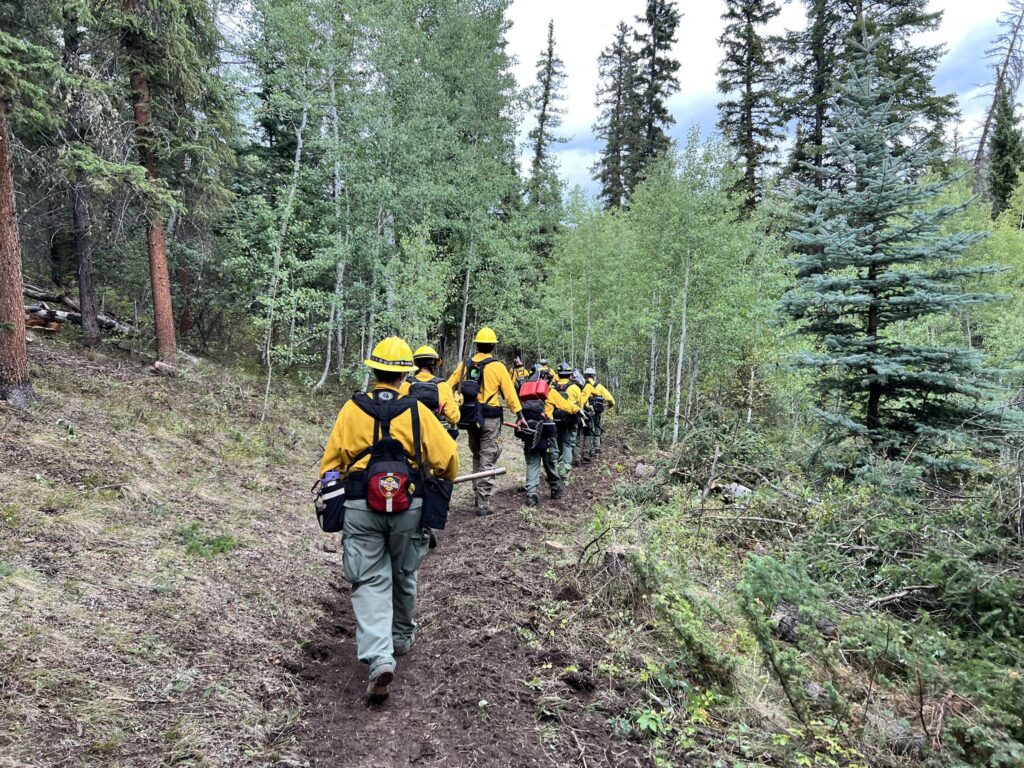
Sometimes the ground is just too steep or rugged for crews to get in safely or quickly. That’s when helicopters become essential.
From shuttling firefighters into remote areas, to hauling tools and gear, to dropping water on hot spots, and even extracting crews when needed, helicopters give firefighters the access and support they need to get the job done.
In this video, the Wyoming Hotshots are flown into the Hack Lake area to reach the fire from above and work their way around the perimeter. Using aircraft in this way helps improve both safety and efficiency for firefighters on the ground.
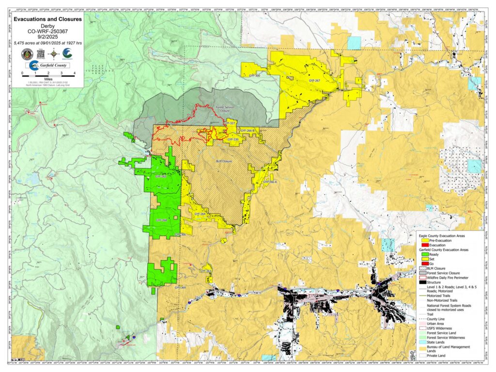
Fire Information: 970-355-3283 Size: 5,475acres Total Personnel: 531 Containment: 23% Cause: Lightning Resources: 5 Aircraft | 7 Hand Crews | 26 Engines | 9 Heavy Equipment
Current Situation:
Containment increased to 23% on the Derby Fire, with new gains on the north and south flanks. The fire has burned into a steep rock face on its northern edge which creates a natural barrier to fire spread. Days of dedicated mop-up and cold trailing operations have secured handline and dozer line on the southern edge, contributing to the rise in containment.
Fire intensity increased Monday on the southwestern side of the fire in the area of the county line and West Fork Sheep Creek. Helicopter water drops assisted a fire suppression module on the ground working to extinguish these hot spots. On Tuesday, they will continue their work in the area. Air resources will have a busy day delivering firefighters, medical, and support personnel to all sides of the fire. A hotshot crew will be moved to the north flank of the fire to work direct on the fire’s edge in the West Fork Sheep Creek drainage in the Flat Tops Wilderness Area. Firefighters utilize specific tactics when fighting fire in wilderness areas to minimize near and long-term impacts to the natural environment while most effectively engaging the fire. Additional firefighting resources have arrived on the incident and will be flown to the northeastern corner where they will work south extinguishing hotspots on the fire’s edge. Hand crews spiked near the West Fork Red Dirt Creek will continue to advance handline construction toward crews working north from Poison Creek. Specialized medical personnel will be staged nearby to assist crews in the event of an emergency.
Weather & Fire Behavior:
Fire activity will continue to increase Tuesday as temperatures will be in the low 70’s. Humidity levels are expected to drop into the teens, with a very low chance of precipitation. Lower humidity levels mean that there’s less moisture in the air and light fuels like grasses, leaves and brush dry out. Light fuels are more sensitive to changes in moisture and are more conducive to burning. Fire behavior analysts don’t expect significant increase in fire behavior; however, firefighters will watch for an increase in creeping, smoldering and isolated tree torching.
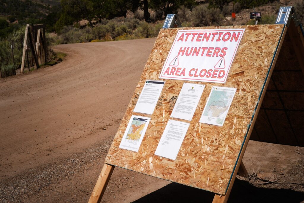
Evacuations and Closures: Fire restrictions and closures remain in place for Bureau of Land Management – Colorado River Valley Field Office areas, https://www.blm.gov/ucr-fire-restrictions. Restrictions and closures remain in the White River National Forest. See Critical and Fire Restriction Forest Alerts at https://www.fs.usda.gov/r02/whiteriver/alerts/.
The Colorado River, Sweetwater, and Red Dirt Creek roads have all been reopened, and the Garfield County and Eagle County Sheriff’s Offices have changed the evacuation status for Sweetwater Valley, Sheep Creek and Red Dirt Creek areas to pre-evacuation (READY) status: https://arcg.is/S0u4G and www.ecemergency.org.
A Temporary Flight Restriction (TFR) is in place over the Derby Fire. For more information, visit https://tfr.faa.gov.
Derby Fire Information
Phone: 970-355-3283 (8:00 a.m. to 8:00 p.m.) Email: 2025.Derby@firenet.gov
Actualización Diaria para el Incendio Derby – el 2 de septiembre de 2025
Equipo 3 del Manejo de Incidentes Complejos del Área de las Montañas Rocosas
Comandantes del Incidente: Casey Cheesbrough, Jay Miller, Ben Sanders
Información del incendio: 970-355-3283 Acres: 5,475 Personal: 531 Contención: 23% Causa: Rayos Recursos: 5 aeronaves | 7 cuadrillas | 26 camiones de bomberos | 9 equipo pesados
Situación Actual:
La contención del incendio Derby aumentó al 23%, con nueva seguridad en los flancos norte y sur. El incendio ha quemado una pared rocosa escarpada en su borde norte, lo que crea una barrera natural para su propagación. Días de operaciones dedicadas de extinción y rastreo en frío han asegurado la línea de fuego manual y la línea de excavadoras en el borde sur, lo que ha contribuido a aumentar la contención.
La intensidad del incendio aumentó el lunes en el lado suroeste, en la zona del límite del condado y West Fork Sheep Creek. El lanzamiento de agua desde helicópteros apoyó a un módulo de extinción de incendios en tierra que trabaja para extinguir estos focos secundarios. El martes, continuarán su trabajo en la zona. Los recursos aéreos tendrán una jornada intensa, transportando bomberos, médicos y personal de apoyo a todos los lados del incendio. Un equipo de bomberos se desplazará al flanco norte del incendio para trabajar directamente en el borde del incendio en el drenaje de West Fork Sheep Creek, en el Flat Tops Wilderness Area. Los bomberos utilizan tácticas específicas al combatir incendios en zonas silvestres para minimizar los impactos a corto y largo plazo en el entorno natural y, al mismo tiempo, combatir el fuego de la manera más eficaz. Recursos adicionales de extinción de incendios han llegado al lugar del incidente y se trasladarán por aire a la zona noreste, donde trabajarán hacia el sur extinguiendo los puntos calientes en el borde del incendio. Las cuadrillas ubicadas cerca de West Fork Red Dirt Creek continuarán avanzando con la construcción de la línea de extinción manual hacia las cuadrillas que trabajan al norte desde Poison Creek. Se desplegará personal médico especializado en las inmediaciones para asistir a las cuadrillas en caso de emergencia.
Clima y el comportamiento del fuego:
La actividad de incendios continuará aumentando el martes, con temperaturas cercanas a los 70°F. Se espera que el nivel de humedad baje entre 10 y 19%, con una probabilidad muy baja de precipitaciones. Una humedad más baja implica menos humedad en el aire y que los combustibles ligeros, como la hierba, las hojas y la maleza, se sequen. Estos combustibles ligeros son más sensibles a los cambios de humedad y más propensos a quemarse. Los analistas del comportamiento del fuego no prevén un aumento significativo; sin embargo, los bomberos estarán atentos a un aumento de incendios sigilosos, latentes y aislados de árboles.
Las restricciones y cierres por incendios se permanecen vigentes en los terrenos bajo la administración de la Oficina de Administración de Tierras del Valle del Río Colorado: https://www.blm.gov/ucr-fire-restrictions. Las restricciones y cierres por incendios se permanecen vigentes en Bosque Nacional White River. Consulte las alertas forestales críticas y de restricciones por incendios en https://www.fs.usda.gov/r02/whiteriver/alerts/.
Se han reabierto los caminos Colorado River Road, Sweetwater Road y Red Dirt Creek. Los condados Eagle y Garfield han cambiado el estado de evacuación para los residentes de Sweetwater Valley, Sheep Creek, y Red Dirt Creek a “LISTOS”, la etapa 1 del proceso de evacuaciones que significa que “esté preparados”: https://arcg.is/S0u4G o https://sites.google.com/eaglec…/ecemergencyespanol/inicio.
Se ha establecido una Restricción Temporal de Vuelo (TFR) sobre el incendio Derby. Para más información, visite https://tfr.faa.gov.
Información sobre el incendio de Derby
Teléfono: 970-355-3283 (de 8:00 a. m. a 8:00 p. m.) Correo electrónico:2025.Derby@firenet.gov
Rocky Mountain Area Complex Incident Management Team 3
#DerbyFire Operations Update, Tuesday, Sept. 2, 2025, Ryan Sharpe Operations Sections Chief, discusses firefighting tactics on the #DerbyFire.
Containment rose to 23% on the Derby Fire with new gains on the north and south flanks. Today will be a busy day for air operations and crews. 80 personnel will be flying to various assignments. Operations Sections Chief Ryan Sharpe explains the duties of the day.
Rocky Mountain Area Complex Incident Management Team 3
When you hear the word “FOBS” in the wildland fire world, what exactly does that stand for and what does it mean? A field observer (FOBS) is someone who is responsible for collecting incident status information and providing those findings to other groups in the incident command system.
In this video, field observer Ryan Ricke explains more about his responsibilities and what his role has been on the Derby Fire. #derbyfire#FireYear2025
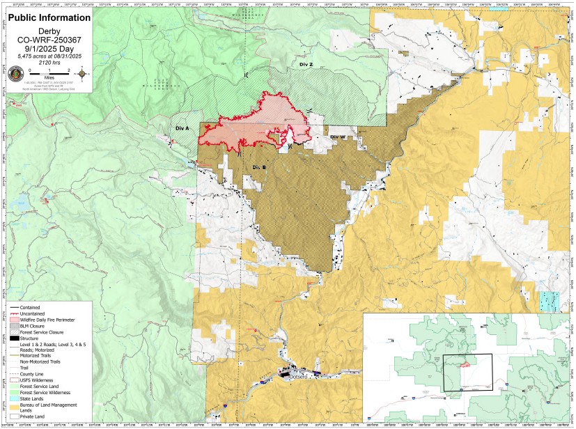
Derby Fire Update – September 1, 2025 Rocky Mountain Area Complex Incident Management Team 3 Casey Cheesbrough, Jay Miller, Ben Sanders Incident Commanders Fire Information: 970-355-3283
Size: 5,475 acres Containment: 6% Total personnel: 578 Cause: Lightning Resources: 4 aircraft, 9 hand crews, 27 engines, 12 heavy equipment
Current situation:
A spike camp is located near West Fork Red Dirt Creek, east of the fire edge, allowing hotshot crews to reduce travel time to where they are building direct line on the fire’s edge. The hotshots are working south to eventually meet crews working up from Poison Creek on the southeast corner. This assignment may take several days to complete.
A combined group of 30 hotshots and highly skilled medical personnel will return by helicopter to the Hack Lake area to continue their work on the western perimeter. Being transported by helicopter allows the crew to save time and conserve energy for the day’s task, rather than making an arduous hike to the fireline. An Unmanned Aerial System (UAS) will scout for areas of heat in spots outside the perimeter in the northwest portion of the fire and south of the Flat Top Wilderness area. UAS reconnaissance flights identify areas of heat providing crews with coordinates to effectively locate them.
Firefighters continue backhauling excess structure protection equipment from areas where it is no longer needed. Crews continue to patrol and monitor the southern portion of the fire, searching out areas of heat and extinguishing them as they work towards containment. Crews will also monitor and maintain structure protection systems that remain along the Sweetwater, Sheep Creek, and Red Dirt Creek roads.
Weather and fire behavior:
Smoke levels are expected to be more noticeable than in previous days as the drying trend continues. Starting Monday, fire activity will increase with rising temperatures and lowering humidity, as seasonal warm and dry pattern returns to Western Colorado this week. Temperatures will stay in the low seventies with a mild 10 miles per hour wind.
Evacuations and closures: Fire restrictions and closures remain in place for lands within the Bureau of Land Management – Colorado River Valley Field Office areas, https://www.blm.gov/ucr-fire-restrictions. Restrictions and closures remain in the White River National Forest. See Critical and Fire Restriction Forest Alerts at https://www.fs.usda.gov/r02/whiteriver/alerts/ .
The Colorado River, Sweetwater, and Red Dirt Creek roads have all been reopened, and the Garfield County and Eagle County Sheriff’s Offices have changed the evacuation status for Sweetwater Valley, Sheep Creek and Red Dirt Creek areas to pre-evacuation (READY) status: https://arcg.is/S0u4G and www.ecemergency.org.
A Temporary Flight Restriction (TFR) is in place over the Derby Fire. All unauthorized aircraft (including drones) are prohibited from flying near the fire, as they can interfere with authorized air support operations. For more information, visit https://tfr.faa.gov.
Derby Fire information Phone: 970-355-3283 (8:00 a.m. to 8:00 p.m.) Email:2025.Derby@firenet.gov
Actualización Diaria para el Incendio Derby – el 1 de septiembre de 2025
Equipo 3 del Manejo de Incidentes Complejos del Área de las Montañas Rocosas
Comandantes del Incidente: Casey Cheesbrough, Jay Miller, Ben Sanders Información del incendio: 970-355-3283
Un campamento secundario se encuentra cerca de West Fork Red Dirt Creek, al este del borde del incendio, lo que permite a los equipos de bomberos “hotshot” (bomberos forestales altamente capacitados y especializados) reducir el tiempo de viaje hasta donde construyen una línea directa en el borde del incendio. Los bomberos trabajan hacia el sur para reunirse con los equipos que trabajan desde Poison Creek en la esquina sureste. Esta tarea podría tardar varios días.
Un grupo combinado de 30 bomberos “hotshot” y personal médico altamente capacitado regresará en helicóptero a la zona de Hack Lake para continuar su trabajo en el perímetro oeste. El transporte en helicóptero permite al equipo ahorrar tiempo y energía para la tarea del día, en lugar de realizar una ardua caminata hasta la línea de fuego. Un Sistema Aéreo No Tripulado (UAS por sus siglas en inglés, o dron) buscará cualquier foco secundario de calor fuera del perímetro, en la parte noroeste del incendio y al sur de la zona silvestre Flat Top Wilderness. Los vuelos de reconocimiento del UAS identifican las zonas de calor, proporcionando a los equipos las coordenadas para localizarlas eficazmente.
Los bomberos continúan retirando el exceso de equipo de protección estructural de las zonas donde ya no se necesita. Los equipos continúan patrullando y monitoreando la zona sur del incendio, buscando áreas de calor y extinguiéndolas mientras trabajan para contenerlo. También monitorearán y darán mantenimiento a los sistemas de protección de estructuras que permanecen a lo largo de las carreteras de Sweetwater, Sheep Creek y Red Dirt Creek.
Clima y el comportamiento del fuego:
Se espera que los niveles de humo sean más visibles que en días anteriores a medida que continúa la tendencia a la sequía. A partir del lunes, la actividad de los incendios aumentará con el aumento de las temperaturas y la disminución de la humedad, ya que el patrón estacional cálido y seco regresa al oeste de Colorado esta semana. Las temperaturas se mantendrán alrededor de los 70°F con vientos suaves de 10mph.
Evacuaciones y cierres: Las restricciones y cierres por incendios se permanecen vigentes en los terrenos bajo la administración de la Oficina de Administración de Tierras del Valle del Río Colorado: https://www.blm.gov/ucr-fire-restrictions. Las restricciones y cierres por incendios se permanecen vigentes en Bosque Nacional White River. Consulte las alertas forestales críticas y de restricciones por incendios en https://www.fs.usda.gov/r02/whiteriver/alerts/.
Se han reabierto los caminos Colorado River Road, Sweetwater Road y Red Dirt Creek. Los condados Eagle y Garfield han cambiado el estado de evacuación para los residentes de Sweetwater Valley, Sheep Creek, y Red Dirt Creek a “LISTOS”, la etapa 1 del proceso de evacuaciones que significa que “esté preparados”: https://arcg.is/S0u4G o https://sites.google.com/eaglecounty.us/ecemergencyespanol/inicio.
Se ha establecido una Restricción Temporal de Vuelo (TFR) sobre el incendio Derby. Se prohíbe a todas las aeronaves no autorizadas (incluidos los drones) volar cerca del incendio, ya que pueden interferir con las operaciones de apoyo aéreo autorizadas. Para más información, visite https://tfr.faa.gov.
Información sobre el Incendio Derby
Teléfono: 970-355-3283 (de 8:00 a. m. a 8:00 p. m.) Correo electrónico: 2025.Derby@firenet.gov
Ops Update Monday morning, Sept. 1, 2025, Ryan Sharpe, Operations Sections Chief, discusses firefighting tactics on the #DerbyFire.
Firefighters are performing multiple operations today. A spike camp located near West Fork Red Dirt Creek has been set up east of the fire edge allowing hotshots to reduce travel time to where they are working direct on the fire perimeter. A group of hotshots will also return by helicopter to the Hack Lake area to continue their work on the western perimeter. Firefighters continue backhauling excess structure protection equipment from areas where it is no longer needed.
The FDNY Incident Management Team sincerely thanks the Meeker community, as well as the firefighters, contractors, and partner agencies who worked tirelessly on the Lee Fire. Thanks to their dedication and resilience, the fire is now 99% contained.
It has been an honor to serve alongside you during this time. The progress made is a direct reflection of the hard work of so many people coming together in a time of need. We leave grateful for the welcome we received and for the opportunity to stand with this community.