Garco Sheriff: Lee Fire approaching Garfield County – resident action needed

Garfield County Emergency Communications Authority

8.9.25, 6:01 a.m. – The Lee and Elk fires in the Meeker area are producing quite a bit of smoke in the valleys of Garfield County due to winds blowing to the south/southwest. There are NO NEW FIRES in GarCo at this time. Please do not call dispatch regarding this smoky haze or strong smell. Some areas of the county are also experiencing falling ash from these same fires.

?For updates and information regarding the Lee and Elk fires, please follow the Elk and Lee Fire Information page.?

Rocky Mountain Complex Incident Management Team 3

8.8.25, 11:26 p.m. – Evening update with Incident Commander Casey Cheesbrough and Operations Planning Chief Tyler Nathe about the evening fire activity on the Lee Fire Rio Blanco County Sheriff’s Office BLM Colorado Fire Colorado Division of Fire Prevention and Control Bureau of Land Management – Colorado Colorado Parks and Wildlife U.S. Forest Service – White River National Forest Bureau of Land Management Fire Garfield County Sheriff’s Office – Colorado Garfield County Emergency Communications Authority


Garfield County Sheriff’s Office and Incident Management Team for the Elk and Lee Fires

8.8.25, 9:30 p.m. – Winds are shifting to move the Meeker area Lee Fire to the southwest toward Highway 13 in southern Rio Blanco County. The Lee Fire is expected to near the Garfield County side overnight or early tomorrow.

Map of fire zones

Map of the fires

Open Fullscreen App

Fire officials are alerting Rio Blanco and Garfield County residents to prepare in Ready Set Go modes.

Residents in the area identified as zone 70 should move into Set status for short notice evacuation likely in your area, and zone 71 should move into Ready status to prepare for possible evacuation in your area.

Prepare for evacuation

Winds have been steadily moving toward the east southeast direction, and while fire behavior is expected to decrease overnight, the Lee Fire may shift southward.

Please register at garco911.com for emergency alerts, follow the fire incident facebook page @elkleefire and the Garfield County Sheriff’s Office page, as well as garfieldcounty.net for further information.

Lee Fire images at sunset
Garco Sheriff: Lee Fire approaching Garfield County – resident action needed

CDPHE: Air quality health advisory for wildfire smoke

Colorado Department of Public Health and Environment

Avisos en Español para todo el Estado (Colorado)

Issued for Routt, Grand, eastern Rio Blanco, Eagle, eastern Garfield, and Jackson counties
Issued at 7:59 AM MDT, Tuesday, August 5, 2025

Issued by the Colorado Department of Public Health and Environment

Affected Area: Routt, Grand, Rio Blanco, Eagle, Garfield and Jackson Counties. Locations include, but are not limited to Steamboat Springs, Granby, Hot Sulphur Springs, Kremmling, Meeker, Rangely, Eagle, Vail, Glenwood Springs and Walden.

Advisory in Effect: 9:00 AM MDT, Tuesday, August 5, 2025 to 9:00 AM MDT, Wednesday, August 6, 2025

Public Health Recommendations: If smoke is thick or becomes thick in your neighborhood you may want to remain indoors. This is especially true for those with heart disease, respiratory illnesses, the very young, and older adults. Consider limiting outdoor activity when moderate to heavy smoke is present. Consider relocating temporarily if smoke is present indoors and is making you ill. If visibility is less than 5 miles in smoke in your neighborhood, smoke has reached levels that are unhealthy.

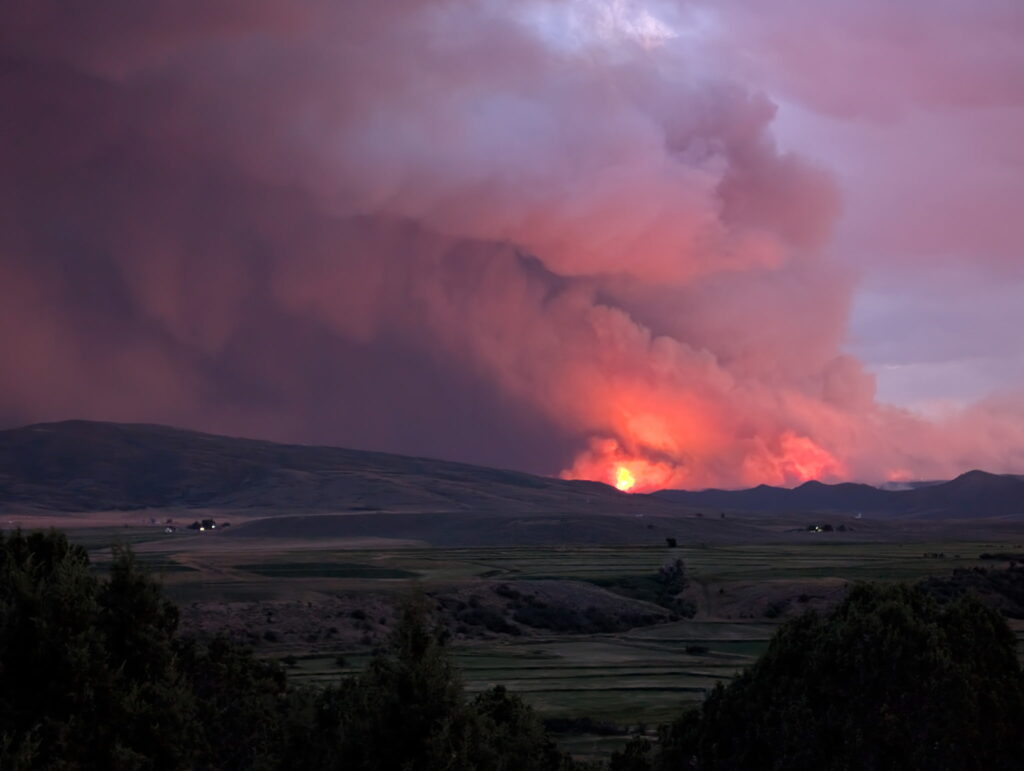
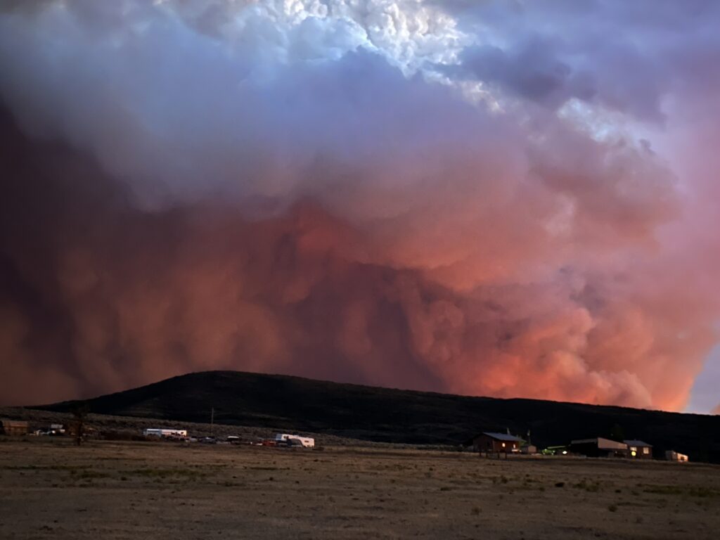
Outlook: Smoke from several fires in Rio Blanco and Garfield counties will produce areas of moderate to heavy smoke on Tuesday and Wednesday. The greatest impacts are expected in areas in the immediate vicinity of these fires, particularly in sheltered areas and low lying terrain. Additional smoke impacts may be experienced across the advisory area due to transport of smoke on Tuesday and Wednesday.

Colorado statewide air quality conditions, forecasts, and advisories

CDPHE: Air quality health advisory for wildfire smoke

Garco911: I-70 open in Glenwood Canyon

Garfield County Emergency Communications Authority

4.22.25, 2:12 p.m. – I-70 is open at Glenwood Springs. Both eastbound lanes are open and one westbound lane.

4.22.25, 1:41 p.m. – Eastbound I-70 is open at Glenwood Springs. Only eastbound lanes are open at this time.

4.22.25, 12:06 p.m. – Road closed: I-70 is closed between mile markers 116-133, both directions, Glenwood Springs to Dotsero, due to an accident.

Garco911: I-70 open in Glenwood Canyon

Garco911 and CDOT: I-70 eastbound reopened after rockslide in Glenwood Canyon

Garfield County Emergency Communications Authority

4.4.25, 6:09 am: I-70 is open at 116 eastbound, main Glenwood Springs exit.

Colorado Department of Transportation

4.3.25, 11:13 pm: Between Exit 114: West Glenwood (Glenwood Springs) and Exit 129: Bair Ranch (6 miles west of Dotsero) from Mile Point 116 to Mile Point 126.5. Road closed – expect delays due to a rock slide.

Comment: This will be an extended closure.

4.3.25, 10:25 pm: Between Exit 114: West Glenwood (Glenwood Springs) and Exit 129: Bair Ranch (6 miles west of Dotsero) from Mile Point 116 to Mile Point 126.5. Road closed – expect delays due to a rock slide. CDOT will post updates at cotrip.org.

Garfield County Emergency Communications Authority

4.3.25, 10:10 pm: I-70 is closed at mile marker 116 eastbound, Glenwood Springs, due to a rock slide in Glenwood Canyon.

Garco911 and CDOT: I-70 eastbound reopened after rockslide in Glenwood Canyon

Garco911 and CDOT: I-70 eastbound closed for rockslide in Glenwood Canyon

Garfield County Emergency Communications Authority

4.4.25, 6:09 am: I-70 is open at 116 eastbound, main Glenwood Springs exit.

Colorado Department of Transportation

4.3.25, 11:13 pm: Between Exit 114: West Glenwood (Glenwood Springs) and Exit 129: Bair Ranch (6 miles west of Dotsero) from Mile Point 116 to Mile Point 126.5. Road closed – expect delays due to a rock slide.

Comment: This will be an extended closure.

4.3.25, 10:25 pm: Between Exit 114: West Glenwood (Glenwood Springs) and Exit 129: Bair Ranch (6 miles west of Dotsero) from Mile Point 116 to Mile Point 126.5. Road closed – expect delays due to a rock slide. CDOT posts all updates at cotrip.org.

Garfield County Emergency Communications Authority

4.3.25, 10:10 pm: I-70 is closed at mile marker 116 eastbound, Glenwood Springs, due to a rock slide in Glenwood Canyon.

Garco911 and CDOT: I-70 eastbound closed for rockslide in Glenwood Canyon