Total acreages: 5,749 acres 6% containment 699 personnel
Building fireline takes all kinds of kinds. On the southeast side of the fire, crews continue to strengthen the fireline and gradually move north along the eastern side. Multiple handcrews and a variety of heavy equipment are working together to advance the fireline.
Taskforce leaders and heavy equipment bosses help coordinate this work. Medical personnel accompany firefighters to keep everyone safe. A field observer follows the progress of the fireline and collects information on the fuels, fire behavior, and on-site weather. #DerbyFire#FireYear2025
Photo: A dozer creates fireline by scraping away plants on the surface of the ground. Where fire creeps along the forest floor, this bare soil creates a barrier that the fire can’t move across without any flammable material to burn. S.Rawding/Derby Fire.
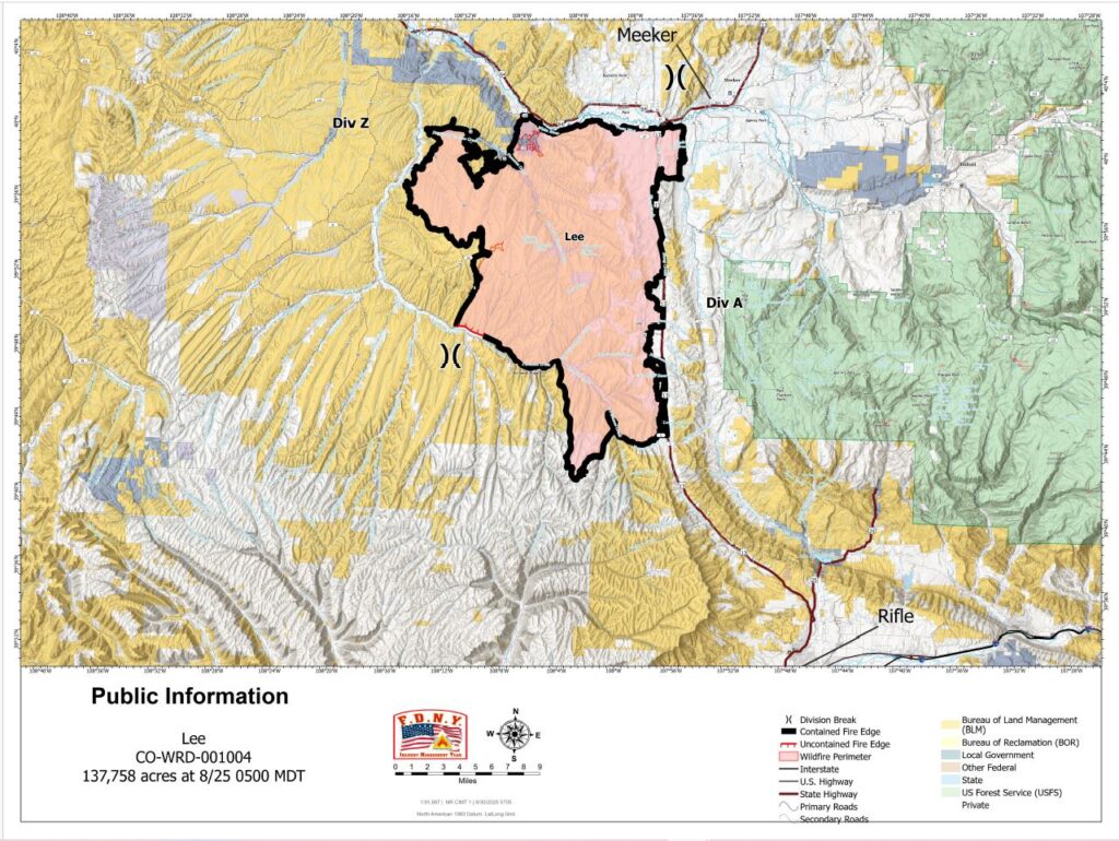
Location: 11 miles south of Meeker, Colorado Start Date: 08/02/2025 Cause: Lightning Size: Lee Fire: 137,758 acres Containment: Lee Fire: 95% 179 Total Personnel; 2 Hand Crews; 2 Dozers
KEY MESSAGE This is the final daily update from the FDNY Incident Management Team. On Monday morning at 0600, command of the fire will transition back to local agencies.
Over the past week, our team has been honored to serve alongside local, state, and federal partners in support of the Lee Fire. We are grateful for the cooperation, resilience, and support shown by the community and those working on the ground. As we prepare to return home, we do so with confidence in both the progress made and the agencies continuing this important work.
CURRENT STATUS Crews have now expanded suppression repair into additional areas of the fire, focusing on debris removal and restoration work. These projects are being completed in close coordination with Resource Advisors to ensure agency standards are met and to lay the groundwork for long-term recovery of the landscape.
WEATHER AND FIRE BEHAVIOR Clear skies and warming temperatures are expected today, accompanied by lower humidity. While the overall forecast points to mild and favorable conditions, there remains a chance for an isolated shower or thunderstorm this afternoon. Any storm activity could bring gusty winds up to 25 mph, which may briefly impact ongoing suppression repair. Looking ahead, the return to drier weather will allow crews to continue making steady progress across the fire area.
OPERATIONAL BRIEFING – AUGUST 30, 2025
August 30, 2025, Operational Briefing with Operations Section Vic Fernandez
CLOSURES AND SPECIAL MESSAGES For accurate up-to-date information on evacuations and road closures for Rio Blanco County, go to the Rio Blanco County Sheriff’s Office Facebook page at: https://www.facebook.com/RioBlancoCountySheriffsOffice.
Fire Information: 970-355-3283 Office Hours: 8 a.m. to 8 p.m.
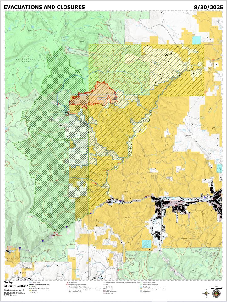
Size: 5,738 acres Total Personnel: 667 Containment: 6% Cause: Lightning Resources: 4 Aircraft | 16 Hand Crews | 36 Engines | 17 Heavy Equipment
Current Situation: Containment increased slightly on the south, west of East Fork Sheep Road. This is where interior heat has decreased, and wind and weather conditions are unlikely to push the fire over the control line. Firefighters continue to patrol, mop up, and extinguish hotspots along the southern control line. Hotshot crews continue to construct fireline along the fire edge on the western side as they progress to the north. Handline construction is progressing on the east side of the fire, extending northward from an existing dozer line. Air resources are evaluating proposed medical evacuation helispots as the firefighters move into more rugged, remote terrain. An Unmanned Aircraft System is also available to help assess fuels, fire behavior and areas of heat using an infrared camera. Structure protection crews are actively monitoring and maintaining defenses around more than 500 structures along Sweetwater Valley, Sheep Creek, and Red Dirt Creek Road.
Weather & Fire Behavior: Recent rainfall has kept relative humidity levels high, helping to minimize fire behavior. Saturday will see slowly clearing skies and sunshine with a slight possibility of rain at higher elevation. A gradual warming and drying trend are expected to begin on Sunday. Relative humidities will start to drop a little each day, however, a few days of drying will be needed before any significant increase in fire activity is likely. Interior heat pockets may continue to produce smoke where dead and downed trees are still smoldering. Fire may slowly creep along the ground in areas where mixed conifer, subalpine fir and lodgepole pine trees transition into aspen stands.
Evacuations and Closures: Fire restrictions and closures remain in place for lands within the Bureau of Land Management – Colorado River Valley Field Office areas and White River National Forest. Find out more at their websites: https://www.blm.gov/ucr-fire-restrictions. See Critical and Fire Restriction Forest Alerts at https://www.fs.usda.gov/r02/whiteriver/alerts/
The Colorado River, Sweetwater, and Red Dirt Creek roads have all been reopened, and the Garfield County and Eagle County Sheriff’s Offices have changed the evacuation status for Sweetwater Valley, Sheep Creek and Red Dirt Creek areas to pre-evacuation (READY) status: https://arcg.is/S0u4G and www.ecemergency.org.
A Temporary Flight Restriction (TFR) is in place over the Derby Fire. All unauthorized aircraft (including drones) are prohibited from flying near the fire, as they can interfere with authorized air support operations. For more information, visit https://tfr.faa.gov.
Derby Fire Information Public Phone Line: (970) 355-3283 Office Hours: 8 a.m. to 8 p.m.
Actualización Diaria para el Incendio Derby –el 30 de agosto de 2025 Equipo 3 del Manejo de Incidentes Complejos del Área de las Montañas Rocosas Comandantes del Incidente: Casey Cheesbrough, Jay Miller, Ben Sanders Información del incendio: 970-355-3283
Situación Actual: La contención aumentó ligeramente al sur, al oeste de East Fork Sheep Road. Aquí es donde el calor interior ha disminuido, y es improbable que las condiciones de viento y clima impulsen el incendio más allá de la línea de control. Los bomberos continúan patrullando, haciendo liquidación y extinguiendo los puntos calientes a lo largo de la línea de control sur. Los equipos de bomberos continúan construyendo una línea de fuego a lo largo del borde del incendio en el lado oeste a medida que avanzan hacia el norte. La construcción de la línea de fuego manual avanza en el lado este del incendio, extendiéndose hacia el norte desde una línea de bulldozer existente. Los recursos aéreos están evaluando los helipuertos propuestos de evacuación médica a medida que los bomberos se adentran en terrenos más accidentados y remotos. Un Sistema de Aviación No Tripulada (dron) también está disponible para ayudar a evaluar los combustibles, el comportamiento del incendio y las áreas de calor mediante una cámara infrarroja. Los equipos de protección de estructuras están monitoreando y manteniendo activamente las defensas alrededor de más de 500 estructuras a lo largo de Sweetwater Valley, Sheep Creek y Red Dirt Creek Road.
Clima y el comportamiento del fuego: Las lluvias recientes han mantenido altos los niveles de humedad relativa, lo que ha ayudado a minimizar el riesgo de incendio. El sábado se despejará lentamente el cielo y habrá sol, con una ligera probabilidad de lluvia en zonas de mayor altitud. Se espera que el domingo comience una tendencia gradual de calentamiento y sequía. La humedad relativa comenzará a descender ligeramente cada día; sin embargo, se necesitarán algunos días de sequía antes de que sea probable un aumento significativo de la actividad del incendio. Es posible que las bolsas de calor interiores sigan produciendo humo donde los árboles muertos y caídos aún arden lentamente. El fuego podría extenderse lentamente por el suelo en zonas donde las coníferas mixtas, los abetos subalpinos y los pinos contortos se transforman en álamos.
Evacuaciones y cierres: Las restricciones y cierres por incendios se permanecen vigentes en los terrenos bajo la administración de la Oficina de Administración de Tierras del Valle del Río Colorado y el Bosque Nacional White River. Para más información, visite su sitio web: https://www.blm.gov/ucr-fire-restrictions. Consulte las alertas forestales críticas y de restricciones por incendios en https://www.fs.usda.gov/r02/whiteriver/alerts/.
Se han reabierto los caminos Colorado River Road, Sweetwater Road y Red Dirt Creek. Los condados Eagle y Garfield han cambiado el estado de evacuación para los residentes de Sweetwater Valley, Sheep Creek, y Red Dirt Creek a “LISTOS”, la etapa 1 del proceso de evacuaciones que significa que “esté preparados”: https://arcg.is/S0u4Go https://sites.google.com/eaglecounty.us/ecemergencyespanol/inicio.
Se ha establecido una Restricción Temporal de Vuelo (TFR) sobre el incendio Derby. Se prohíbe a todas las aeronaves no autorizadas (incluidos los drones) volar cerca del incendio, ya que pueden interferir con las operaciones de apoyo aéreo autorizadas. Para más información, visite https://tfr.faa.gov.
Información sobre el Incendio Derby Teléfono: 970-355-3283 (de 8:00 a. m. a 8:00 p. m.) Correo electrónico: 2025.Derby@firenet.gov
#DerbyFire Ryan Sharpe, Operations Sections Chief, discusses firefighting tactics on the #DerbyFire.
Rocky Mountain Area Complex Incident Management Team 3 took command of the Derby Fire from Northern Rockies Incident Management Team 3 this Saturday morning, August 30th at 6AM. While higher relative humidity values continue to moderate fire activity today, firefighters are building control line as directly as possible along the fire edge. Hotshot crews are advancing handline along the southwestern side of the fire, beginning to turn the corner to move up to the western edge. Patrolling and mop-up continue on the southern edge. Crews are strengthening and widening handline, moving south from the Sugarloaf Lake area toward the cold fire edge on the southeastern side. Handline construction continues on the east side of the fire, moving north.
Location: 11 miles south of Meeker, Colorado Start Date: 08/02/2025 Cause: Lightning Size: Lee Fire: 137,758 acres Containment: Lee Fire: 95% 195 Total Personnel; 8 Engines; 2 Hand Crews; 2 Water Tenders; 2 Dozers
KEY MESSAGE
Containment of the Lee Fire has increased to 95 percent. The addition of black line on the map reflects steady progress by firefighters patrolling the perimeter and completing suppression repair. Crews continue to strengthen lines and ensure the fire remains within its current footprint as work moves toward full containment.
CURRENT STATUS
Suppression repair is progressing across multiple areas, with crews conducting debris removal and other restoration work in coordination with Resource Advisors. These efforts are being carried out to agency standards and are designed to support long-term recovery.
WEATHER AND FIRE BEHAVIOR
Scattered rain showers are expected to continue into Saturday morning. While an isolated light shower or thunderstorm is possible in the afternoon, conditions will trend warmer and drier through the weekend. Temperatures are forecast to return to the 80s. Winds will generally be from the east at 5 mph, with gusts up to 17 mph possible near thunderstorms.
Rocky Mountain Area Complex Incident Management Team 3
Incident Commanders Casey Cheesbrough, Jay Miller, Ben Sanders
Derby Fire Quick Facts: August 30, 2025 Location: 13 miles north of Dotsero, CO Start Date: 8/16/2025 Cause: Lightning Size: Est. 5,738 acres Completion/Containment: 6% Total personnel 667
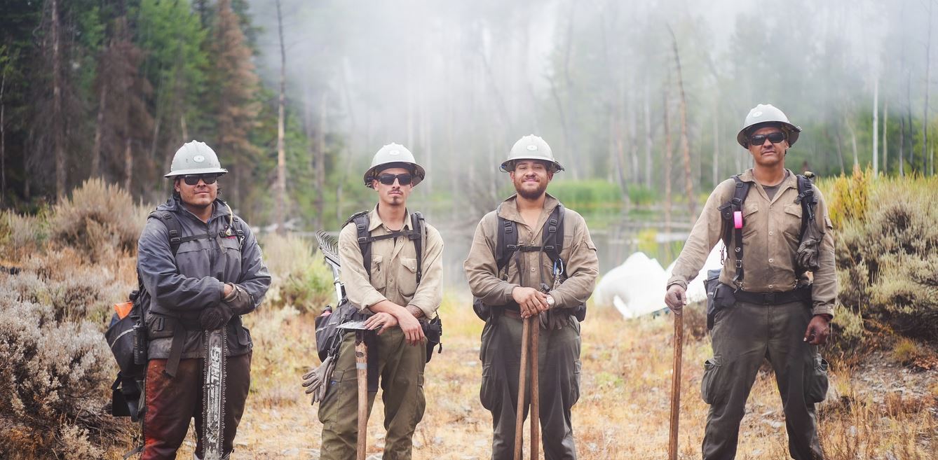
Hand crews, such as the one pictured, serve as the “boots on the ground” in wildfire suppression. They are able to access difficult terrain where machinery may not and may hike long distances to reach the fireline. These crews are generally made up of a sawyer or “bucker,” who builds hand line by cutting trees to clear the path ahead. The bucker is followed by the “swamper” who removes the cut debris from the path. Following them comes a line of multiple diggers, swiping with a hand tool, continuing to advance down the line. Working together, they gradually clear vegetation to mineral soil, which the fire is unable to creep across.
These hand crews carry line gear that weighs about 35-40 pounds. It contains protective equipment, tools, water, snacks, a sack lunch and a Meal Ready to Eat (MRE), if needed. All of this is to keep them fueled and prepared for the immense and difficult work that they do every day.
Photo: The Mimbres 1 Type 2 Crew, based in Socorro, New Mexico, pose with the tools they use to build control line, including a chainsaw and specialized hoes. The backpack straps they’re wearing secure their line gear as they work. This crew had been working to build and improve control line on the southeast side of the fire. They demobilized Saturday and will return to their base to rest and refurbish their tools and equipment before their next assignment. – S.Rawding/Derby Fire.
Location: 11 miles south of Meeker, Colorado Start Date: 08/02/2025 Cause: Lightning Size: Lee Fire: 137,758 acres Containment: Lee Fire: 90% 218 Total Personnel; 9 Engines; 2 Hand Crews; 2 Water Tenders; 2 Dozers
KEY MESSAGE The Lee Fire remains 137,758 acres with 90 percent containment. Fire activity has been minimal, with no growth observed. An infrared (IR) flight detected only a few hot spots, all of which were well inside the fire’s edge. Recent rainfall has kept conditions favorable, though crews remain mindful of flash flooding and debris flows that may follow periods of heavy rain.
CURRENT STATUS Today, firefighters will continue patrols along the fire’s edge to ensure it remains within its footprint. Suppression repair is underway in several areas, including debris removal, with crews working closely with Resource Advisors to complete this work to agency standards and support long-term recovery. Progress remains steady as work continues toward full containment and recovery of the fire area.
WEATHER AND FIRE BEHAVIOR Widespread rain showers are expected on Friday morning and will continue through much of the day. Some heavier showers may produce lightning and thunder. Conditions are forecast to dry out by late afternoon, with clearing skies into the evening. The rainfall will help keep fire activity minimal, though crews will remain alert for lightning strikes and the potential for flash flooding or debris flows in and around the burn area.
CLOSURES AND SPECIAL MESSAGES For accurate up-to-date information on evacuations and road closures for Rio Blanco County go to the Rio Blanco County Sheriff’s Office Facebook page at: https://www.facebook.com/RioBlancoCountySheriffsOffice.
Northern Rockies Complex Incident Management Team 3
Total acreage: 5,735 acres 5% contained 692 personnel
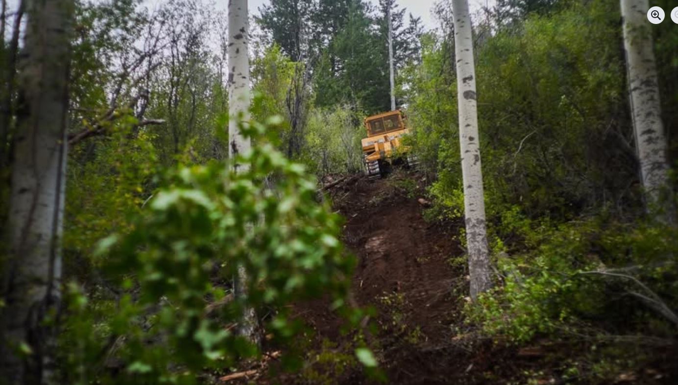
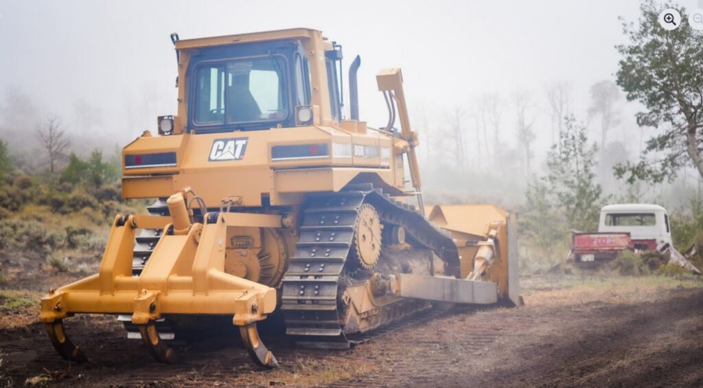
Many kinds of heavy equipment are used on the fire line to clear the area of consumable fuel. By removing trees and brush to mineral soil, they create “fuel breaks” that reduce the fire’s spread.
In this photo, a bulldozer works to scrape vegetation off the surface of the ground. Hand crews may work ahead of dozer operations as “boots on the ground” to cut trees and brush within the dozer’s path.
As of August 26th, there have been approximately 8 miles of bulldozer line put in along the south and west sides of the fire area.
Photo: Taken on the constructed bulldozer line on the Southeast corner of the Derby Fire. S. Rawding/Derby Fire
Northern Rockies Complex Incident Management Team 3
Long term fire analyst, Erin Noonan-Wright, gives an extended outlook regarding fire behavior on the Derby Fire. A fire progression map illustrates the growth of the fire over time. The fire has spread primarily through a mixed conifer/subalpine fir fuel type, slowed in stands of aspen. Long term fire analysts consider trends in winds, rainfall, soil and fuels drought and historical fire behavior to make predictions about how and where the fire could grow.