Northern Rockies Complex Incident Management Team 3
#DerbyFire Ops Update Monday morning, Aug. 28, 2025. Philip Knaub, Operations Sections Chief, discusses firefighting tactics on the Derby Fire. Sunbreaks are rekindling smoldering conifer trees at higher elevations within the fire perimeter and smoke will be visible during periods of sunshine today. Heat remains despite the rain. Firefighters are building secondary control lines on the eastern side of the fire where hazardous terrain, snags, and heavier fuel types make safe access more difficult. Control line construction continues on the southeastern fire edge. Firefighters are mopping up (removing and extinguishing burning vegetation) and patrolling completed control lines. On the west side, incident managers are evaluating a potential spike camp location for smokejumpers to more easily access the most active part of the fire. We expect to see an increase in containment over the next few days.
Northern Rockies Complex Incident Management Team 3
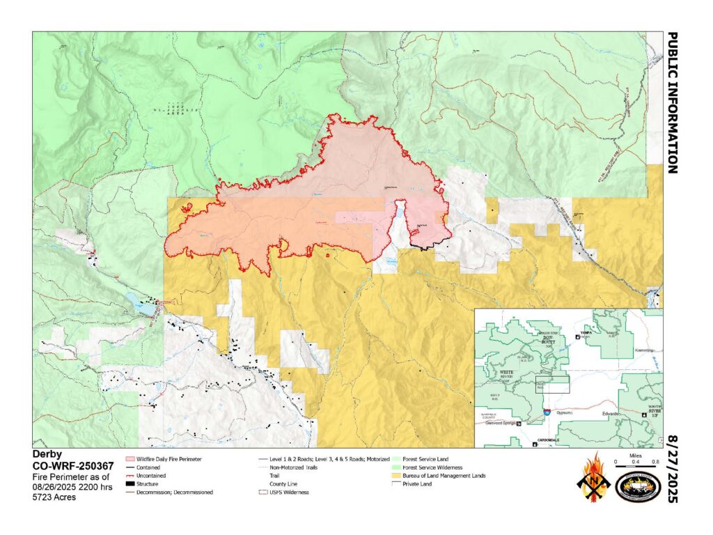
Derby Fire Quick Facts: August 28, 2025 Total acreage: 5,723 acres 4% contained 824 personnel
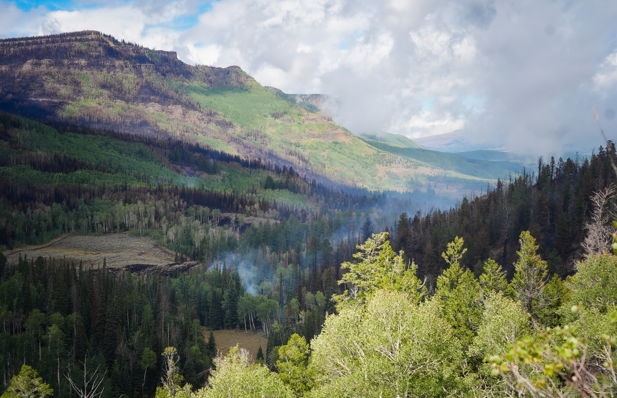
Firefighters continue to strengthen control line along the southeastern side of the fire. Within the fire footprint, smoke may be visible as sunlight rekindles isolated areas of smoldering timber. The mix of wetting and drying weather, varying winds, and patchwork fuel types lead to inconsistent fuel consumption across the incident. The rock outcrop in the rear of the photo is near the fire origin.
Photo: Looking northwest from Sugarloaf Mountain on the southeast side of the Derby Fire. S.Rawding/Derby Fire.
Northern Rockies Complex Incident Management Team 3
Wildland firefighting can be dangerous work, and our crews are always preparing for the unexpected. In this video, a Forest Service fire suppression module practices training for what to do if a firefighter is hurt on the fireline or in a remote area. These drills make sure that if the unfortunate happens, crews are ready to take care of each other and get everyone home safe.
Northern Rockies Complex Incident Management Team 3
Today marks the wrap-up of operations at the Livestock Evacuation Center in Eagle County. Many residents have safely picked up their animals and returned home. We’re grateful to everyone who helped care for these animals during the fire response, and to the community for their support. The Small Animal Shelter remains open for anyone who still needs a safe place for pets.
Northern Rockies Complex Incident Management Team 3, Incident Commander Mike Behrens
Location: 13 miles north of Dotsero, CO Start Date: 8/16/2025; Cause: Lightning Size: Est. 5,723 acres Completion/Containment: 4% 864 total personnel
KEY MESSAGE:
The Colorado River, Sweetwater, and Red Dirt Creek roads have all been reopened. The Garfield and Eagle County Sheriff’s Offices have changed the evacuation status for Sweetwater Valley and Sheep Creek and Red Dirt Creek areas to pre-evacuation (READY) status. The Forest Service and BLM have both reduced the size of their closure areas. Firefighters have built almost 11 miles of control lines, and the Derby Fire has been declared 4% contained.
CURRENT STATUS:
Showers have temporarily moderated fire activity this week, but incident managers predict wildfire activity will increase again when the weather warms and fuels dry out. Firefighters have constructed almost 11 miles of handlines and dozerlines along the east, south, and west fire perimeters. The Derby Fire has been declared 4% contained. The term “containment” is used when fire managers are confident that wind and weather conditions will not push the fire past completed control lines. Crews will work to strengthen and widen fire lines as weather and conditions allow. Air support is scouting for potential helispot sites, and structure protection crews are continuing to improve fire defenses around more than 500 structures along Sweetwater Road and Red Dirt Creek Road.
WEATHER AND FIRE BEHAVIOR:
Incident meteorologists predict that showers will continue Wednesday and probably through the rest of this week before warmer weather returns early next week. Daytime smoke and nighttime fire glows may be visible at times when fuels dry out and fire activity increases.
CLOSURES AND SPECIAL MESSAGES:
The Colorado River, Sweetwater, and Red Dirt Creek Roads have all been reopened, and the Garfield County and Eagle County Sheriff’s Offices have changed the evacuation status for Sweetwater Valley, Sheep Creek and Red Dirt Creek areas to pre-evacuation (READY) status. More evacuation information is available at https://arcg.is/S0u4G and www.ecemergency.org.
Equipo 3 de Gestión de Incidentes Complejos de las Montañas Rocosas del Norte, Comandante de Incidente Mike Behrens
Ubicación: 13 millas al oeste de Dotsero, CO Fecha de inicio: 08/16/2025; Causa: Rayos Tamaño: Est. 5723 acres Finalización/Contención: 4% 864 Personal total
MENSAJE CLAVE:
Se han reabierto los caminos Colorado River Road, Sweetwater Road y Red Dirt Creek Road. Las Oficinas del Sheriff del Condado de Garfield y del Condado de Eagle han cambiado el estado de evacuación de las áreas de Sweetwater Valley, Sheep Creek y Red Dirt Creek a pre-evacuación (LISTOS). El Servicio Forestal y la Oficina de Administración de Tierras (BLM por sus siglas en inglés) han reducido el tamaño de sus zonas de cierre. Los bomberos han construido casi 11 millas de líneas de control, y el incendio Derby ha sido declarado contenido en un 4%.
ESTADO ACTUAL:
Las lluvias han moderado temporalmente la actividad del incendio esta semana, pero los administradores del incidente predicen que la actividad del incendio aumentará de nuevo cuando el clima mejore y los combustibles se sequen. Los bomberos han construido casi 11 millas de líneas de mano y líneas de excavadora a lo largo de los perímetros este, sur y oeste del incendio. El incendio Derby ha sido declarado contenido en un 4%. El término “contención” se utiliza cuando los administradores del incendio confían en que las condiciones del viento y el clima no extenderán el incendio más allá de las líneas de control ya establecidas. Los equipos trabajarán para reforzar y ampliar las líneas de control según lo permitan el clima y las condiciones. El apoyo aéreo está explorando posibles ubicaciones para helipuertos, y los equipos de protección de estructuras continúan mejorando las defensas contra incendios en torno a más de 500 estructuras a lo largo de Sweetwater Road y Red Dirt Creek Road.
COMPORTAMIENTO DEL CLIMA Y EL FUEGO
Los meteorólogos del incidente pronostican que las lluvias continuarán el miércoles y probablemente durante el resto de la semana, antes de que el clima sea más cálido a principios de la próxima semana. Es posible que se observen humo diurno y resplandores de fuego nocturno cuando los combustibles se sequen y aumente la actividad del incendio.
CIERRES Y MENSAJES ESPECIALES
Se han reabierto los caminios Colorado River Road, Sweetwater Road y Red Dirt Creek. Los condados Eagle y Garfield han cambiado el estado de evacuación para los residentes de Sweetwater Valley, Sheep Creek, y Red Dirt Creek a “LISTOS”, la etapa 1 del proceso de evacuaciones que significa que “esté preparados”. Para más información, incluido dónde refugiarse y recursos para mascotas y ganado, visite https://arcg.is/S0u4G o https://sites.google.com/eaglec…/ecemergencyespanol/inicio.
El Servicio Forestal y el BLM han reducido el tamaño de sus áreas de cierre. La orden de cierre y el mapa del Bosque Nacional White River están publicados en https://www.fs.usda.gov/r02/whiteriver. La orden de cierre y el mapa de la Oficina de Campo del Valle del Río Colorado de BLM se publican en https://www.blm.gov/…/blm-issues-land-closure-garfield…. Existe una restricción temporal de vuelo (TFR por sus siglas en inglés) sobre el incendio de Derby.
Northern Rockies Complex Incident Management Team 3
#DerbyFire Ops Update Monday morning, Aug. 27, 2025. Philip Knaub, Operations Sections Chief, discusses firefighting tactics on the Derby Fire. The Derby Fire is now 4% contained. Firefighters were able to access the southeast fire perimeter yesterday and are confident that any changes in weather conditions will not push the fire over the control line in this area. Look for a black line on the fire map to illustrate containment. Rain reached most areas of the fire yesterday, however, dead and down trees continue to hold heat. Large fuels are slow to accept moisture and will continue to smolder. As the weather dries out later this week, we expect to see more active fire behavior. On the east and west sides of the fire perimeter, firefighters are scouting for opportunities to continue to build line with handcrews and heavy equipment.
Northern Rockies Complex Incident Management Team 3
Derby Fire Weather update 8-27-2025
Incident Meteorologist, Ryan Fliehman, discusses the upcoming weather forecast. Light rain is expected throughout the morning today, with a chance of thunderstorms this afternoon. This wet pattern will continue through Thursday, with a slow drying trend beginning on Friday, extending through the weekend.
Northern Rockies Complex Incident Management Team 3
Derby Fire Quick Facts: August 27, 2025 Total acreage: 5,723 acres 2% contained 864 personnel
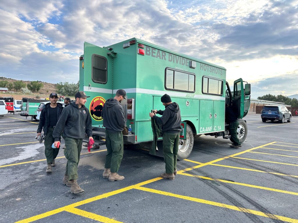
While not all Hotshot buggies are painted @U.S. Forest Service green, their shape and size is very recognizable! Hotshot crews are highly trained and specialized handcrews, often given the most physically demanding work on a large wildfire. Their transport vehicles are their “home away from home” on an incident and have just enough space for ten crew members and their gear.
Photo: The Bear Divide Hotshots from Santa Clarita, CA take care of their crew buggy and organize their gear. L.Edlund/Derby Fire.
Northern Rockies Complex Incident Management Team 3
The #DerbyFire gained almost two hundred more personnel over recent days, primarily additional handcrews and engines. Resource needs are evaluated daily and increased or decreased depending on the needs of the fire. When local and regional resources are already engaged responding to fires, resources may come from all over the country to assist. Personnel may serve up to 14-21 day shifts before they’re required to come off an incident to rest. #FireYear2025
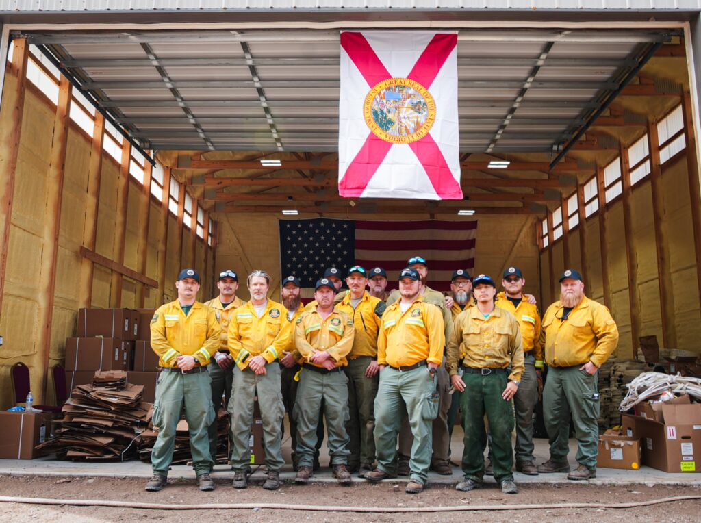
Photo: A Florida Suppression Module gather for a photo where they were organizing and preparing structure protection equipment in the Sweetwater Canyon area during the rains on Monday, August 25, 2025. S.Rawding/Derby Fire.