Northern Rockies Complex Incident Management Team 3
Long term fire analyst, Erin Noonan-Wright, gives an extended outlook regarding fire behavior on the Derby Fire. A fire progression map illustrates the growth of the fire over time. The fire has spread primarily through a mixed conifer/subalpine fir fuel type, slowed in stands of aspen. Long term fire analysts consider trends in winds, rainfall, soil and fuels drought and historical fire behavior to make predictions about how and where the fire could grow.
Heat lingers in heavy fuels in the higher elevation areas of the Derby Fire. The term “heavy fuel” refers to dead trees (also called snags) that are larger than 3 inches in diameter. Large stumps, standing snags and fallen logs are all included in this category.
The larger size of these dead trees makes them slow to ignite, but once smoldering, they’ll hold heat for extended amounts of time. It can take multiple weeks for them to adjust to changes to moisture levels in the atmosphere – earning them the label of “1,000 hour fuels.”
On Wednesday, August 27, 2025, firefighters worked to construct handline on the southeast side of the Derby Fire. When crews encounter burning snags as they construct control lines they use a variety of tools to extinguish the flames. S.Rawding/Derby Fire.
Northern Rockies Complex Incident Management Team 3, Incident Commander Mike Behrens
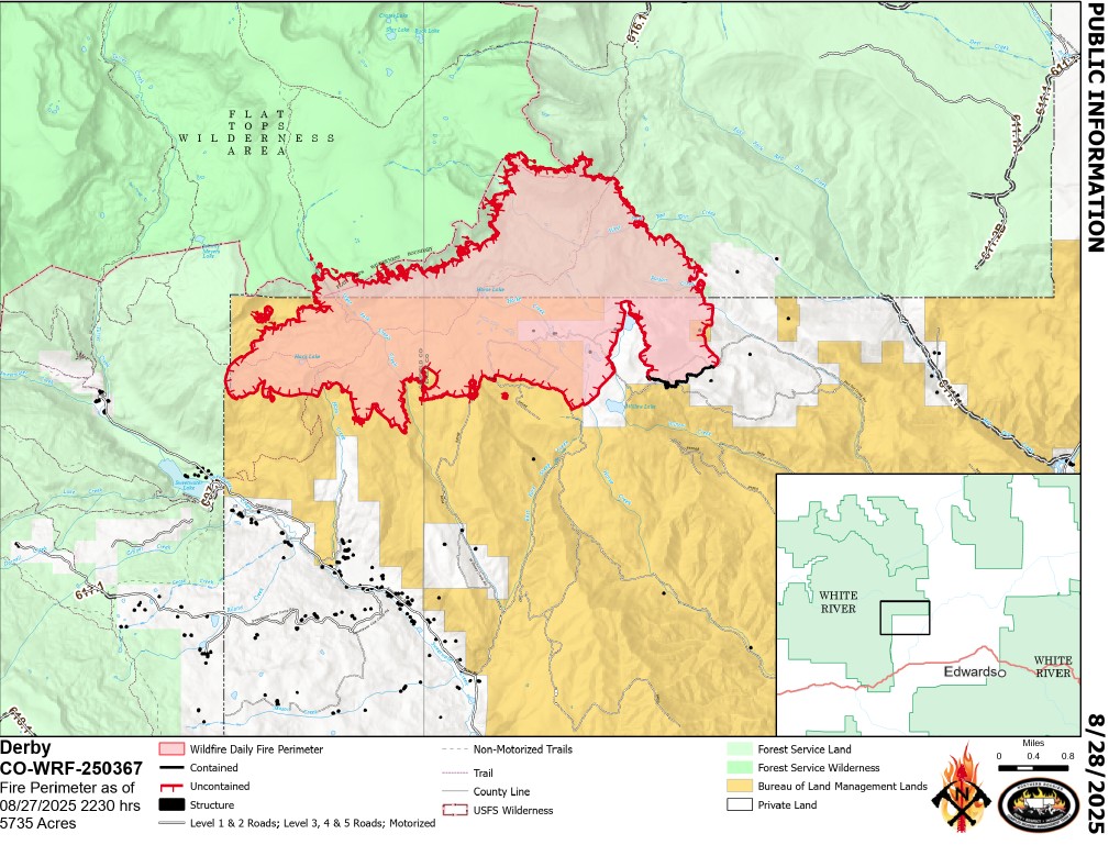
Location: 13 miles north of Dotsero, CO Start Date: 8/16/2025; Cause: Lightning Size: Est. 5,735 acres Completion/Containment: 5% Total personnel: 824
Key message:
Firefighters continue to build and strengthen control lines and scout for access routes. Smoke may be visible as interior fuels reheat during sunbreaks. Wet weather will temporarily moderate fire activity until drier conditions return.
Current status:
Firefighters are actively assessing fireline construction routes on the western side of the fire. Scouting involves mapping proposed routes and detailing the type and number of resources needed. Along the southwestern edge of the fire, crews are reinforcing control lines by searching for lingering heat and removing or extinguishing still smoldering vegetation. Called mopping up, this fire suppression tactic prevents fire spread as it limits the opportunity for embers to roll or blow across the control line into unburned fuels. On the southeastern and eastern edges firefighters are using chainsaws, hand tools and heavy equipment to continue to build line. Crews are building secondary control lines on the eastern side of the fire where hazardous trees and heavier fuel types prohibit working directly on the fire’s edge. Air resources are evaluating proposed helispot locations to have medical evacuation sites closer to where firefighters are working. Structure protection crews continue to improve and maintain fire defenses around more than 500 structures along Sweetwater Road and Red Dirt Creek Road.
Weather and fire behavior:
Cool and humid weather conditions continue over the next few days. Remnants of hurricane Juliette is expected to bring showers Friday These scattered storms will bring moisture and produce gustier winds. Drier, warmer weather is predicted Monday or Tuesday. Minimal fire behavior is expected, but daytime smoke may be visible. When periods of sunlight dry and warm vegetation, fire activity is increasing at higher elevation areas within the fire perimeter. Dead and downed trees hold heat where hot surfaces are not exposed to moisture. The fire may creep slowly in aspen stands that have not burned completely.
Closures and special messages:
The Colorado River, Sweetwater, and Red Dirt Creek Roads have all been reopened, and the Garfield County and Eagle County Sheriff’s Offices have changed the evacuation status for Sweetwater Valley, Sheep Creek and Red Dirt Creek areas to pre-evacuation (READY) status. More evacuation information is available at https://arcg.is/S0u4G and www.ecemergency.org.
Equipo 3 de Gestión de Incidentes Complejos de las Montañas Rocosas del Norte,Comandante de Incidente Mike Behrens
Ubicación: 13 millas al oeste de Dotsero, CO Fecha de inicio: 08/16/2025; Causa: Rayos Tamaño: Est. 5,735 acres Finalización/Contención: 5% Personal total: 824
Mensaje clave:
Los bomberos continúan construyendo y reforzando las líneas de control y buscando rutas de acceso. Es posible que se observe humo a medida que los combustibles interiores se recalientan durante los claros de sol. El clima húmedo moderará temporalmente la actividad del fuego hasta que se reanude condiciones secas.
Estado actual:
Los bomberos están evaluando activamente las rutas de construcción de las líneas de fuego en el lado oeste del incendio. La exploración consiste en mapear las rutas propuestas y detallar el tipo y la cantidad de recursos necesarios. A lo largo del borde suroeste del incendio, los equipos están reforzando las líneas de control buscando zonas de calor remanente y retirando o extinguiendo la vegetación aún latente. Esta táctica de extinción, denominada liquidación, previene la propagación del fuego, ya que limita la posibilidad de que las brasas rueden o soplen a través de la línea de control hacia combustibles no quemados. En los bordes sureste y este, los bomberos están utilizando motosierras, herramientas manuales y equipo pesado para continuar construyendo la línea. Los equipos están construyendo líneas de control secundarias en el lado este del incendio, donde la presencia de árboles peligrosos y combustibles más pesados ??impide trabajar directamente en el borde del incendio. Los recursos aéreos están evaluando la ubicación propuesta de helipuertos para tener sitios de evacuación médica más cerca de donde trabajan los bomberos. Los equipos de protección de estructuras continúan mejorando y manteniendo las defensas contra incendios alrededor de más de 500 estructuras a lo largo de Sweetwater Road y Red Dirt Creek Road.
Comportamiento del clima y el fuego
Las condiciones climáticas frescas y húmedas continuarán durante los próximos días. Se espera que los remanentes del huracán Juliette traigan lluvias el viernes. Estas tormentas dispersas traerán humedad y producirán vientos más racheados. Se pronostica un clima más seco y cálido el lunes o martes. Se espera un comportamiento mínimo del fuego, pero podría verse humo durante el día. Cuando los períodos de luz solar secan y calientan la vegetación, la actividad del fuego aumenta en las zonas de mayor altitud dentro del perímetro del incendio. Los árboles muertos y derribados retienen el calor donde las superficies calientes no están expuestas a la humedad. El fuego podría propagarse lentamente en los arboledas de álamos temblones que no se han quemado completamente.
Cierres y mensajes especiales
Se han reabierto los caminos Colorado River Road, Sweetwater Road y Red Dirt Creek. Los condados Eagle y Garfield han cambiado el estado de evacuación para los residentes de Sweetwater Valley, Sheep Creek, y Red Dirt Creek a “LISTOS”, la etapa 1 del proceso de evacuaciones que significa que “esté preparados”. Para más información, incluido dónde refugiarse y recursos para mascotas y ganado, visite https://arcg.is/S0u4G o https://sites.google.com/eaglecounty.us/ecemergencyespanol/inicio.
Northern Rockies Complex Incident Management Team 3
Derby Fire weather update 8-27-2025:
Incident Meteorologist, Jason Straub, discusses the upcoming weather forecast.
More light rain last night and early this morning. Cumulative total is 0.7″. Much lower chances of rain today as we switch to a drying period instead of monsoonal flow.
Smoke continues from smoldering with some single tree torching observed yesterday.
Northern Rockies Complex Incident Management Team 3
#DerbyFire Ops Update Monday morning, Aug. 28, 2025. Philip Knaub, Operations Sections Chief, discusses firefighting tactics on the Derby Fire. Sunbreaks are rekindling smoldering conifer trees at higher elevations within the fire perimeter and smoke will be visible during periods of sunshine today. Heat remains despite the rain. Firefighters are building secondary control lines on the eastern side of the fire where hazardous terrain, snags, and heavier fuel types make safe access more difficult. Control line construction continues on the southeastern fire edge. Firefighters are mopping up (removing and extinguishing burning vegetation) and patrolling completed control lines. On the west side, incident managers are evaluating a potential spike camp location for smokejumpers to more easily access the most active part of the fire. We expect to see an increase in containment over the next few days.
Northern Rockies Complex Incident Management Team 3
Derby Fire Quick Facts: August 28, 2025 Total acreage: 5,723 acres 4% contained 824 personnel
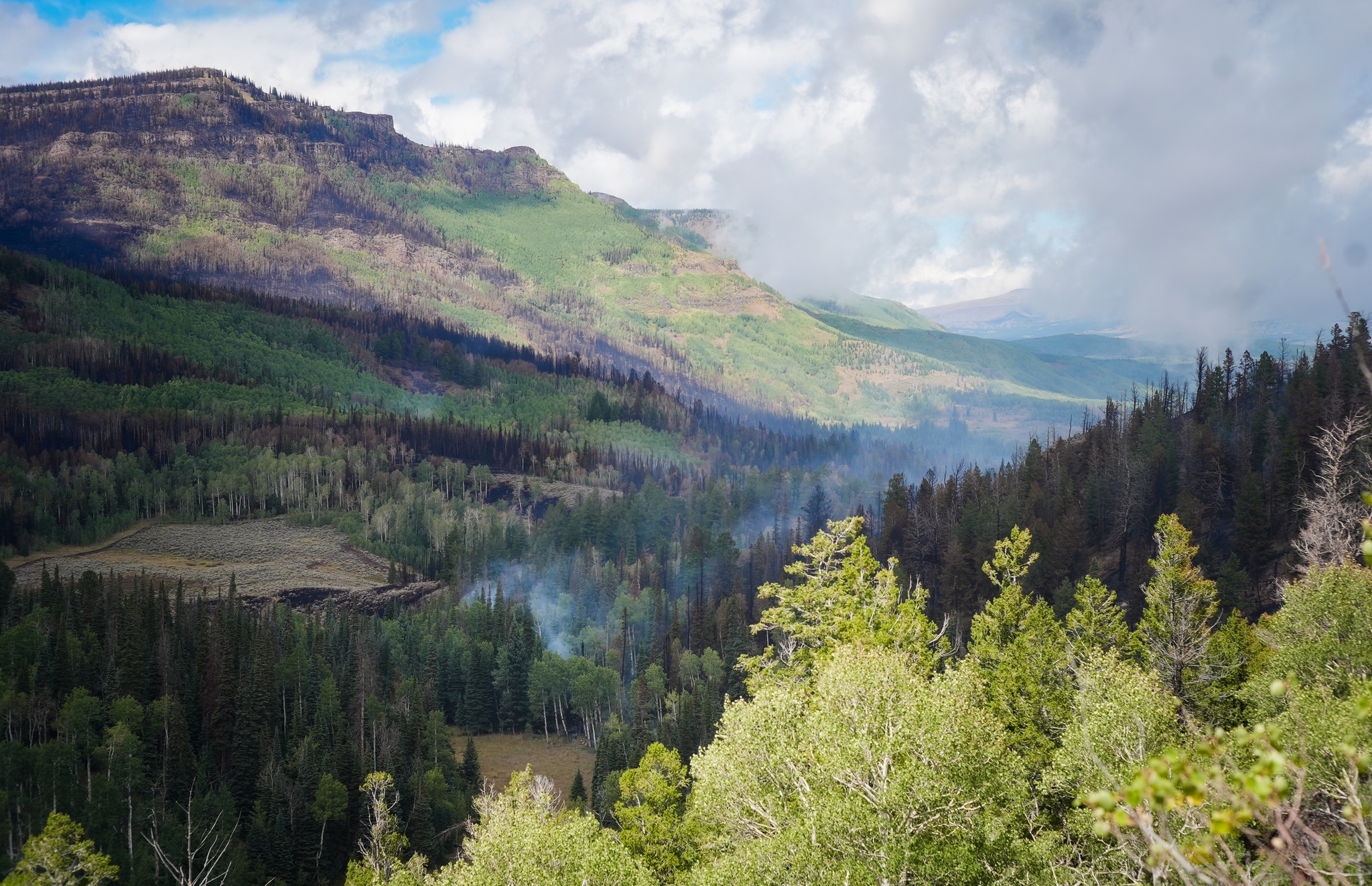
Firefighters continue to strengthen control line along the southeastern side of the fire. Within the fire footprint, smoke may be visible as sunlight rekindles isolated areas of smoldering timber. The mix of wetting and drying weather, varying winds, and patchwork fuel types lead to inconsistent fuel consumption across the incident. The rock outcrop in the rear of the photo is near the fire origin.
Photo: Looking northwest from Sugarloaf Mountain on the southeast side of the Derby Fire. S.Rawding/Derby Fire.
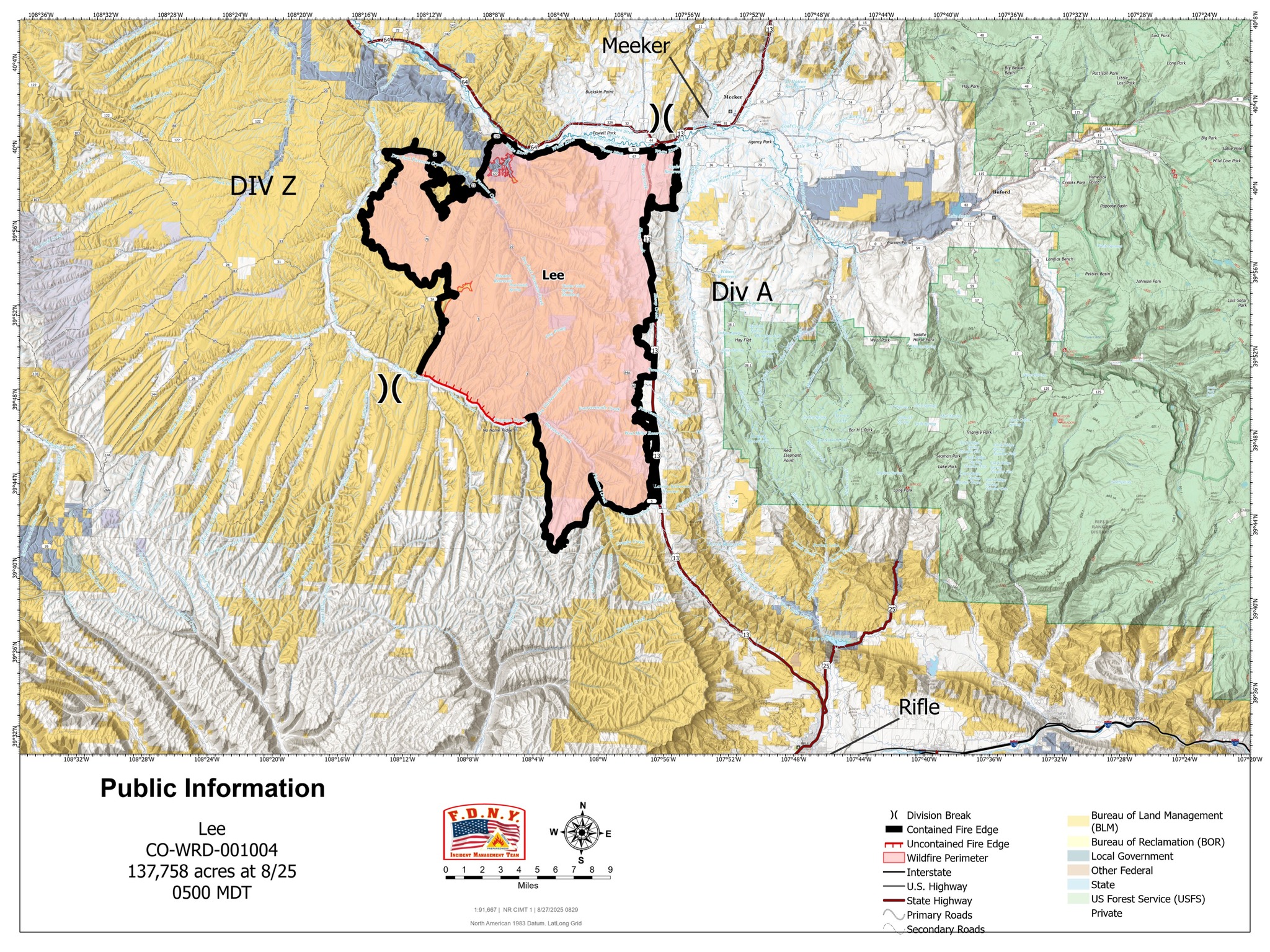
Location: 11 miles south of Meeker, Colorado Start Date: 08/02/2025 Cause: Lightning Size: Lee Fire: 137,758 acres Containment: Lee Fire: 90% 215 Total Personnel; 9 Engines; 2 Hand Crews; 2 Water Tenders; 2 Dozers
CURRENT STATUS
Crews will continue patrols along the fire perimeter today to ensure it stays within its current footprint. Suppression repair operations are moving forward in close coordination with Resource Advisors and local agencies, following the approved Suppression Repair Plan.
Repair work is addressing areas disturbed by suppression activities, with crews working to stabilize firelines, restore ground conditions, and remove equipment no longer needed on the line. These efforts are an important step in reducing impacts and supporting long-term recovery efforts across the fire area.
Progress continues steadily as firefighters remain focused on these repair and patrol operations while working toward complete containment.
WEATHER AND FIRE BEHAVIOR
Storm chances remain in the forecast, with the highest potential for development on the southern portion of the fire. Storms are expected to track from the southwest to the northeast, with the best opportunity for development between 10:30 and 11:30 a.m. If skies clear during the late morning, storms are likely to form and bring rain, lightning, and the potential for localized flooding; if clouds remain in place, conditions may stay limited to lighter, scattered showers.