Rocky Mountain Area Complex Incident Management Team 3
Casey Cheesbrough, Jay Miller, Ben Sanders Incident Commanders
Derby Fire update document
Derby Fire update document – Spanish
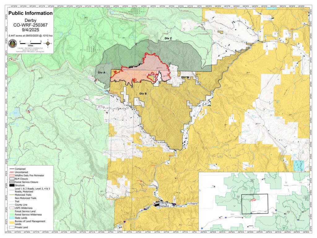
Derby Fire public information map
Derby Fire public information map – Spanish
Fire Information: 970-355-3283
Size: 5,447
Total Personnel: 526
Containment: 42%
Cause: Lightning
Resources: 5 Aircraft | 8 Hand Crews | 21 Engines | 7 Heavy Equipment
Current Situation:
The precipitation we received last week coupled with lower temperatures offered us an opportunity for firefighters to take suppression actions along the fire’s edge. Incident managers are taking proactive action to consider firefighter and equipment needs to most efficiently and effectively engage the fire.
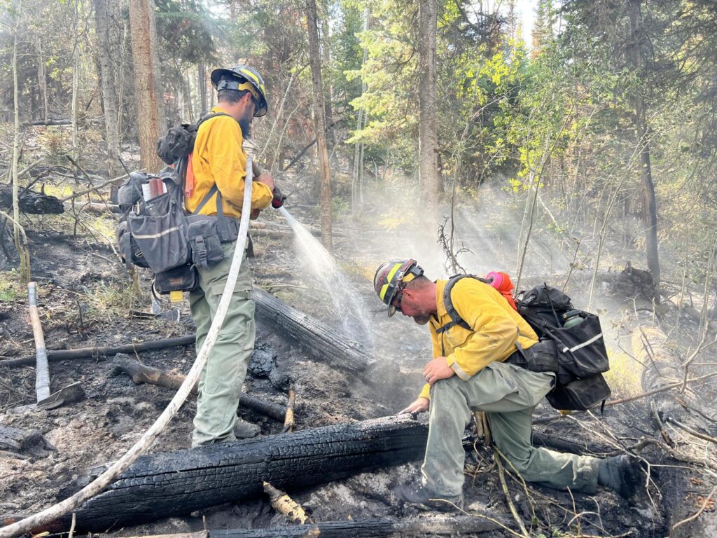
Firefighters are using Minimum Impact Suppression Tactics (MIST) as they work in the Flat Top Wilderness Area. The crews are currently utilizing aviation assets which include unmanned aviation systems (UAS) to support all aspects of their operation.
Crews continue their work on the southeast side of the fire as they continue to construct fireline from the southeast corner up to West Fork Red Dirt Creek. As containment increases on the southern side of the fire, firefighters will focus on patrolling and mopping up isolated heat around cabins and a portion of the Ute-Sweetwater Trail. When patrolling the firelines, crews or engines are rechecking their previous work and validating there are no signs of smoke or heat that indicate the fire is still active.
On the northeastern side of the fire, crews continue to build fireline towards each other, one from the south end, and one from the north end. As crews are working, other fire personnel will follow them mopping up as they contain the fireline. Crews will utilize helicopters to transport hose, pumps, and fuel to support the firefighters’ efforts. They’ll also bring back debris from crews and spike camps, helping ensure the ground is left clean.
Weather & Fire Behavior:
High pressure has moved out of the region, allowing moisture back to the area and lower temperatures in the 70’s. Thursday will be partly cloudy with chances of isolated showers which will keep the potential for fire spread minimal.
Evacuations and Closures:
Fire restrictions and closures remain in place for Bureau of Land Management – Colorado River Valley Field Office areas, https://www.blm.gov/ucr-fire-restrictions. Restrictions and closures remain in the White River National Forest. See Critical and Fire Restriction Forest Alerts at https://www.fs.usda.gov/r02/whiteriver/alerts/.
The Colorado River, Sweetwater, and Red Dirt Creek roads have all been reopened, and the Garfield County and Eagle County Sheriff’s Offices have changed the evacuation status for Sweetwater Valley, Sheep Creek and Red Dirt Creek areas to pre-evacuation (READY) status: https://arcg.is/S0u4G and www.ecemergency.org.
A Temporary Flight Restriction (TFR) is in place over the Derby Fire. All unauthorized aircraft (including drones) are prohibited from flying near the fire, as they can interfere with authorized air support operations. For more information, visit https://tfr.faa.gov.
Derby Fire Information
Phone: 970-355-3283 (8:00 a.m. to 8:00 p.m.)
Email: 2025.Derby@firenet.gov
Actualización Diaria para el Incendio Derby – el 4 de Septiembre de 2025
Equipo 3 del Manejo de Incidentes Complejos del Área de las Montañas Rocosas
Comandantes del Incidente: Casey Cheesbrough, Jay Miller, Ben Sanders
Información del incendio: 970-355-3283
Acres: 5,447
Personal: 526
Contención: 42%
Causa: Rayos
Recursos: 5 aeronaves | 8 cuadrillas | 21 camiones de bomberos | 7 equipo pesados
Situación Actual:
Las precipitaciones de la semana pasada, junto con las temperaturas más bajas, brindaron a los bomberos la oportunidad de implementar medidas de extinción en el borde del incendio. Los gestores de incidentes están tomando medidas proactivas para considerar las necesidades de los bomberos y el equipo necesario para combatir el incendio de la manera más eficiente y eficaz.
Los bomberos están utilizando Tácticas de Extinción de Mínimo Impacto (MIST, por sus siglas en inglés) mientras trabajan en la zona silvestre Flat Top Wilderness. Las cuadrillas están utilizando recursos aéreos, incluyendo sistemas de aviación no tripulados (UAS por sus siglas en inglés, o dron), para apoyar todos los aspectos de su operación.
Las cuadrillas continúan trabajando en el lado sureste del incendio, construyendo una línea de fuego desde la esquina sureste hasta West Fork Red Dirt Creek. A medida que aumenta la contención en el lado sur del incendio, los bomberos se centrarán en patrullar y eliminar el calor aislado alrededor de las cabañas y una parte del Ute-Sweetwater Trail. Al patrullar las líneas de fuego, las cuadrillas o los camiones de bomberos están revisando su trabajo previo y validando que no haya señales de humo o calor que indiquen que el incendio sigue activo.
En el lado noreste del incendio, los equipos continúan construyendo una línea de fuego que se dirige hacia sí, una desde el extremo sur y otra desde el extremo norte. Mientras trabajan, otros bomberos los acompañarán en la liquidación mientras contienen la línea de fuego. Los equipos utilizarán helicópteros para transportar mangueras, bombas y combustible en apoyo a los bomberos. También traerán escombros de los equipos y reubicarán los campamentos, asegurando así que el terreno quede limpio.
Clima y el comportamiento del fuego:
La alta presión se ha alejado de la región, lo que permite que la humedad regrese al área y las temperaturas bajen.
Evacuaciones y cierres:
Las restricciones y cierres por incendios se permanecen vigentes en los terrenos bajo la administración de la Oficina de Administración de Tierras del Valle del Río Colorado: https://www.blm.gov/ucr-fire-restrictions. Las restricciones y cierres por incendios se permanecen vigentes en Bosque Nacional White River. Consulte las alertas forestales críticas y de restricciones por incendios en https://www.fs.usda.gov/r02/whiteriver/alerts/.
Se han reabierto los caminos Colorado River Road, Sweetwater Road y Red Dirt Creek. Los condados Eagle y Garfield han cambiado el estado de evacuación para los residentes de Sweetwater Valley, Sheep Creek, y Red Dirt Creek a “LISTOS”, la etapa 1 del proceso de evacuaciones que significa que “esté preparados”: https://arcg.is/S0u4G o https://sites.google.com/eaglec…/ecemergencyespanol/inicio.
Se ha establecido una Restricción Temporal de Vuelo (TFR) sobre el incendio Derby. Se prohíbe a todas las aeronaves no autorizadas (incluidos los drones) volar cerca del incendio, ya que pueden interferir con las operaciones de apoyo aéreo autorizadas. Para más información, visite https://tfr.faa.gov.
Información sobre el Incendio Derby
Teléfono: 970-355-3283 (de 8:00 a. m. a 8:00 p. m.)
Correo electrónico: 2025.Derby@firenet.gov
______________________________________________________________________________________
Derby Fire official information
FACEBOOK – Derby fire @derbyfire
INCIWEB – Derby Fire
WHITE RIVER NATIONAL FOREST – facebook.com/whiteriverNF @whiteriverNF
_______________
EAGLE COUNTY INFO
DERBY FIRE: EAGLE COUNTY EVACUATION MAP REGISTER FOR ALERTS – 911 alerts
INCIDENT UPDATES – EC Emergency or Reachwell app
FACEBOOK – facebook.com/eaglecountyso @eaglecountyso
________________
GARFIELD COUNTY INFO
DERBY FIRE: GARFIELD COUNTY INTERACTIVE EVACUATION MAP
REGISTER FOR ALERTS – 911 alerts or Reachwell app
INCIDENT UPDATES / SUBSCRIBE – Garfield County emergency
FACEBOOK – facebook.com/garcosheriff @garcosheriff