Rocky Mountain Area Complex Incident Management Team 3
Casey Cheesbrough, Jay Miller, Ben Sanders Incident Commanders
Derby Fire smoke outlook – English
Derby Fire smoke outlook – Spanish
Fire Information: 970-355-3283
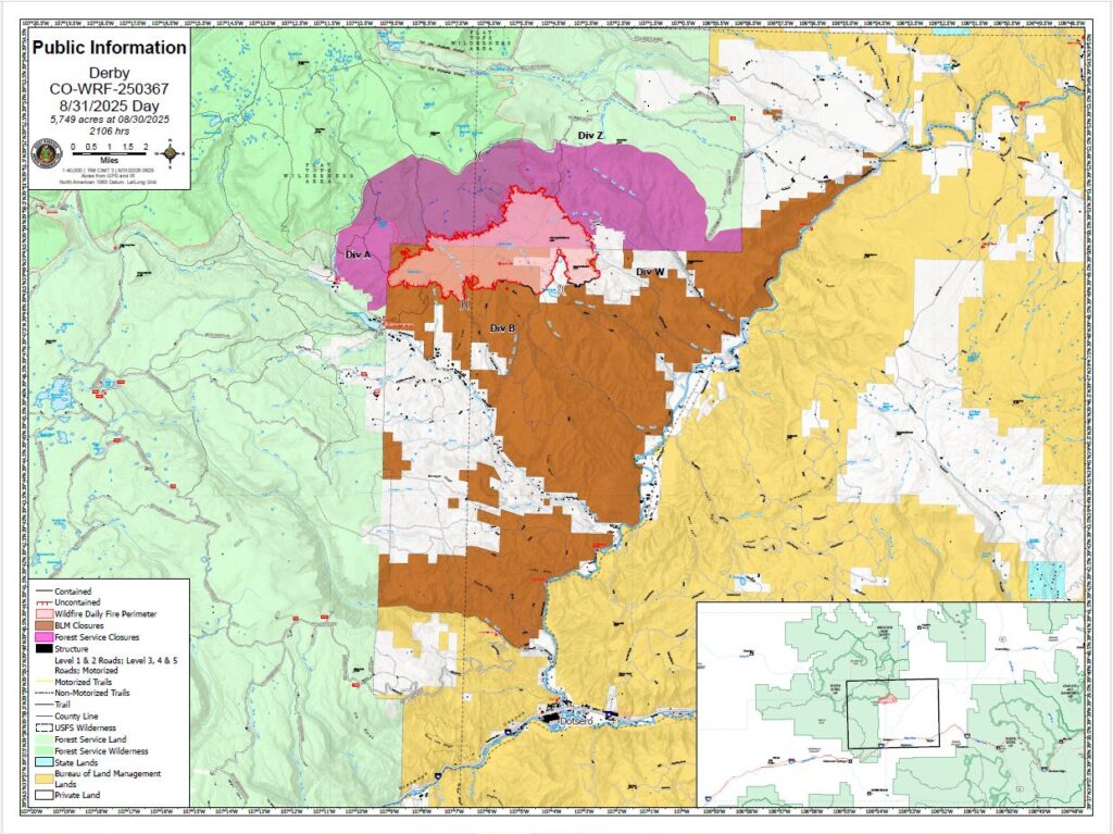
Size: 5,749 acres
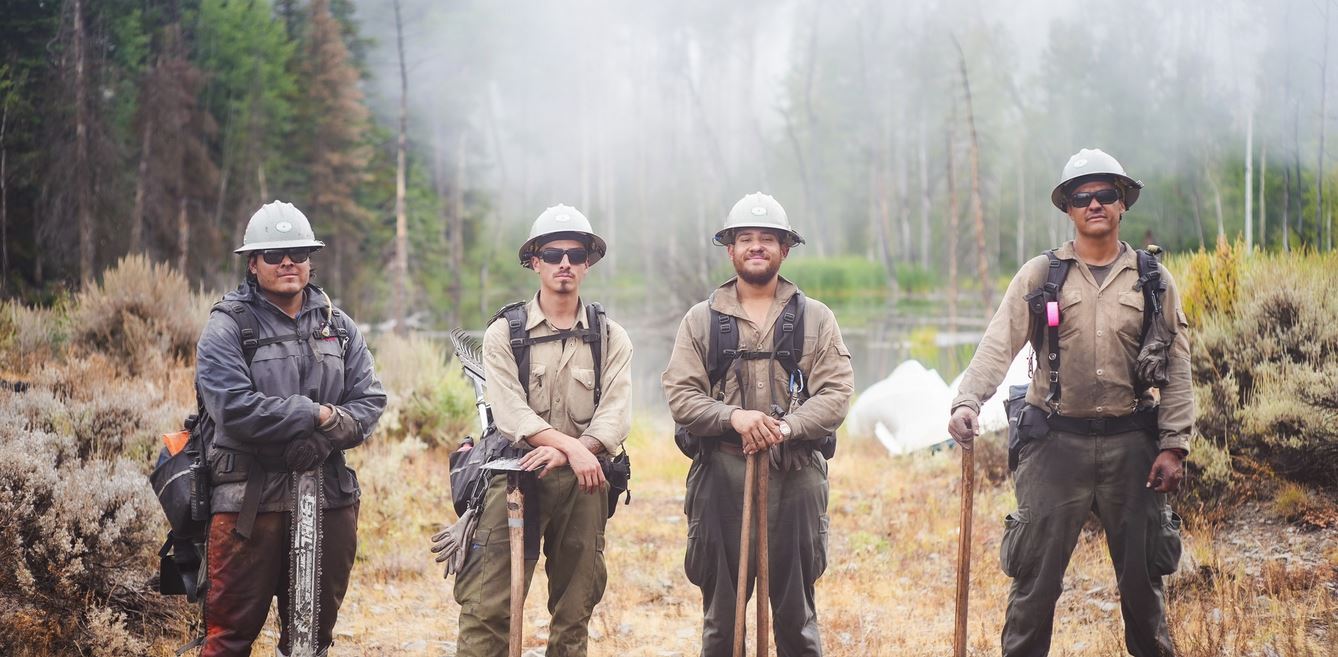
Total Personnel: 699
Containment: 6%
Cause: Lightning
Resources: 4 Aircraft | 14 Hand Crews | 36 Engines | 17 Heavy Equipment
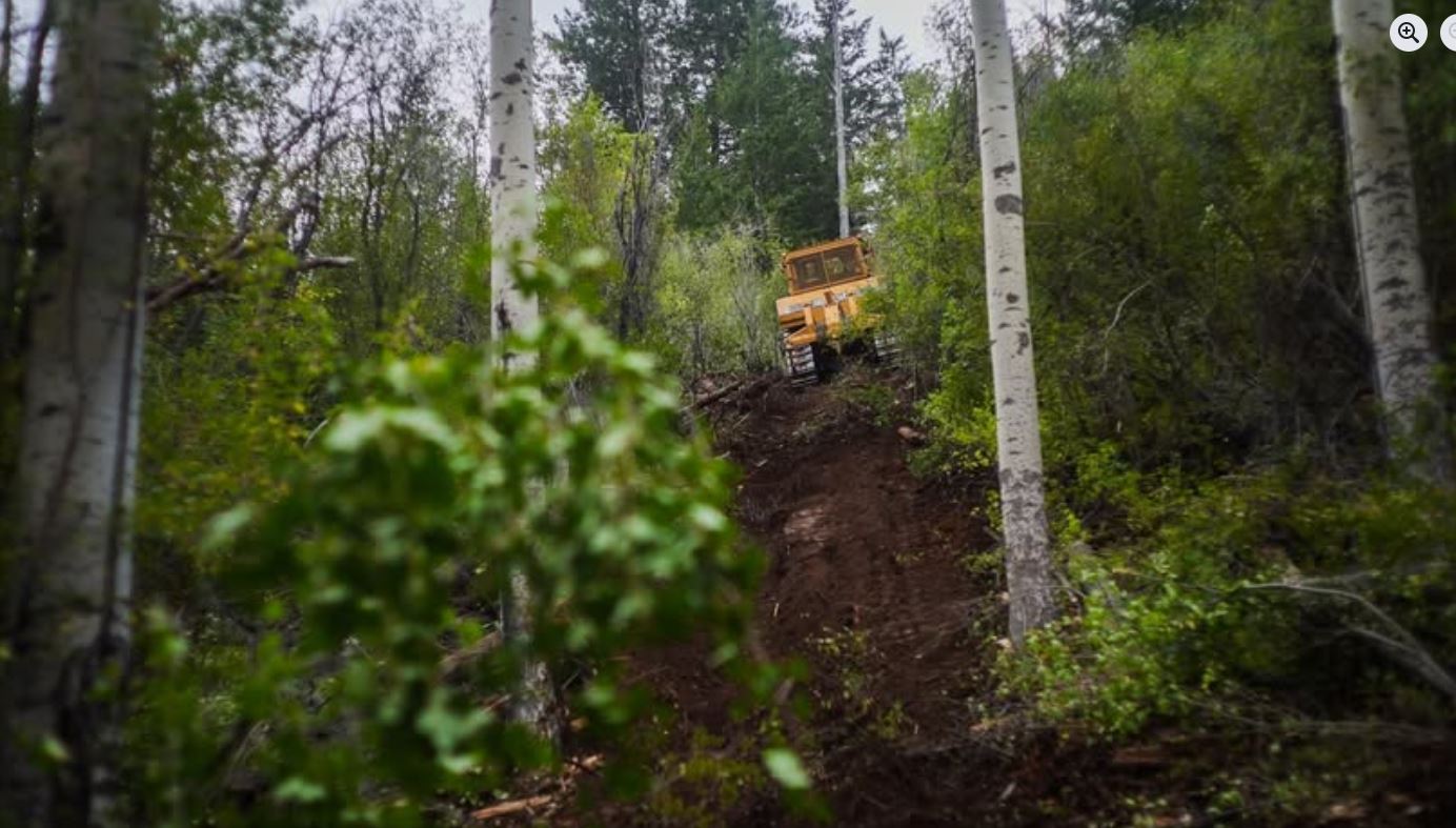
Current Situation: Firefighters are working directly along the fire’s edge to take advantage of moderated fire activity ahead of an upcoming warming trend. Crews advanced handline construction on the southwest corner of the fire Saturday. To have them closer to their work area, a hotshot crew will be flown into the area Sunday with a REMS (Rapid Extraction Module Support team). This is a specialized team that can provide a high-level of medical care and rapid extraction if needed. An Unmanned Aerial System will help support firefighters by scouting for heat in the area and to alert them of safety hazards.
Crews continue to construct indirect handline on the eastern perimeter of the fire, moving north. They are evaluating hand line construction options closer to the fire’s edge, as well as looking for potential helicopter medivac spots to support the ability to work in the steep terrain. This area has a higher concentration of mixed conifer and subalpine fir trees. Heat remains in the dead and downed timber. Fire weakened trees in this area can pose a threat to firefighter safety. Falling snags are a common hazard on the fireline.
The structure protection crews are monitoring fire defenses along Sweetwater, Sheep Creek, and Red Dirt Creek roads. Firefighters are beginning to remove hose lays, pumps and sprinklers around structures in Sweetwater Valley closer to the Colorado River corridor where the fire threat has lessened. Initial attack resources have been identified among the structure protection crew to respond to assist local resources with any new fire starts that occur within the Temporary Flight Restriction (TFR) area of the Derby Fire.
Weather & Fire Behavior: Sunday will be the beginning of a warmer and dryer trend in the area. There is also a limited chance of precipitation with slight winds. Humidity will dip into the 20% range, which can result in grass, pine needles, twigs, and other light fuels to lose moisture and increase fire activity. Expect more smoldering and creeping of the fire due to the drier, warmer weather.
For air-quality and smoke outlook information: https://outlooks.wildlandfiresmoke.net/outlook/4d276598
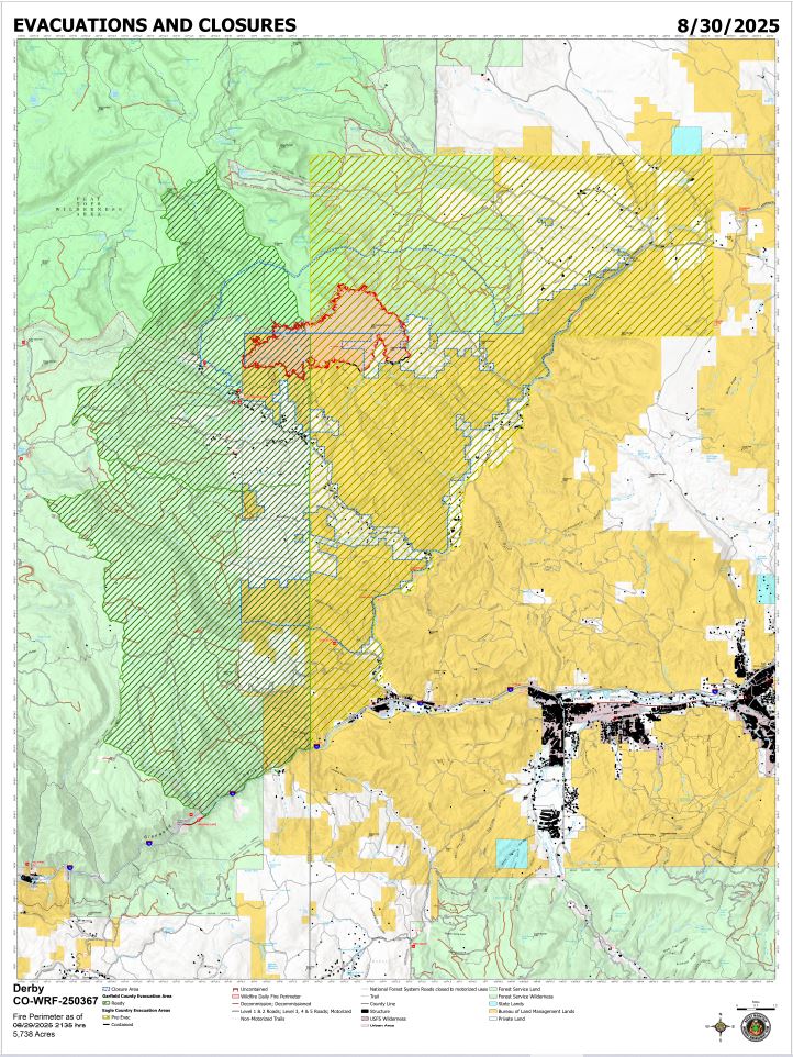
Evacuations and Closures: Fire restrictions and closures remain in place for lands within the Bureau of Land Management – Colorado River Valley Field Office areas and White River National Forest. Find out more at their websites: https://www.blm.gov/ucr-fire-restrictions. See Critical and Fire Restriction Forest Alerts at https://www.fs.usda.gov/r02/whiteriver/alerts/ .
The Colorado River, Sweetwater, and Red Dirt Creek roads have all been reopened, and the Garfield County and Eagle County Sheriff’s Offices have changed the evacuation status for Sweetwater Valley, Sheep Creek and Red Dirt Creek areas to pre-evacuation (READY) status: https://arcg.is/S0u4G and www.ecemergency.org.
A Temporary Flight Restriction (TFR) is in place over the Derby Fire. All unauthorized aircraft (including drones) are prohibited from flying near the fire, as they can interfere with authorized air support operations. For more information, visit https://tfr.faa.gov.
Derby Fire Information
Public Phone Line: (970) 355-3283
Office Hours: 8 a.m. to 8 p.m.
https://inciweb.wildfire.gov/incident-closures/cowrf-derby-fire
https://www.facebook.com/DerbyFire
Actualización Diaria para el Incendio Derby – el 31 de agosto de 2025
Equipo 3 del Manejo de Incidentes Complejos del Área de las Montañas Rocosas
Comandantes del Incidente: Casey Cheesbrough, Jay Miller, Ben Sanders
Información del incendio: 970-355-3283
Acres: 5,749
Personal: 669
Contención: 6%
Causa: Rayos
Recursos: 4 aeronaves | 14 cuadrillas | 36 camiones de bomberos | 17 equipo pesados
Situación Actual: Los bomberos trabajan directamente en el borde del incendio para aprovechar la actividad moderada del mismo ante la inminente tendencia al calentamiento. El sábado, los equipos avanzaron en la construcción de la línea de control manual en el extremo suroeste del incendio. Para acercarlos a su área de trabajo, el domingo se trasladará por helicóptero una cuadrilla de “hot shots” (bomberos forestales altamente capacitados y especializados) con un equipo médico de extracción rápida de emergencia (REMS, por sus siglas en inglés). Este equipo especializado puede brindar atención médica de alta calidad y una extracción rápida en caso necesario. Un Sistema Aéreo No Tripulado (UAS por sus siglas en inglés, o dron) apoyará a los bomberos, detectando el calor en la zona y alertándolos sobre riesgos de seguridad.
Los equipos continúan construyendo una línea de mano indirecta en el perímetro este del incendio, avanzando hacia el norte. Están evaluando opciones de construcción de líneas de mano más cerca del borde del incendio, así como buscando posibles puntos de evacuación médica para helicópteros para apoyar el trabajo en el terreno escarpado. Esta zona presenta una mayor concentración de coníferas mixtas y abetos subalpinos. El calor permanece en los árboles muertos y caídos. Los árboles debilitados por el fuego en esta zona pueden representar una amenaza para la seguridad de los bomberos. La caída de árboles muertos es un peligro común en la línea de fuego.
Los equipos de protección de estructuras están monitoreando las defensas contra incendios a lo largo de los caminos de Sweetwater, Sheep Creek y Red Dirt Creek. Los bomberos están comenzando a retirar los tendidos de mangueras, bombas y rociadores alrededor de las estructuras en Sweetwater Valley, más cerca del corredor del Colorado River, donde la amenaza de incendio ha disminuido. Se han identificado recursos de ataque inicial entre el equipo de protección de estructuras para responder y apoyar a los recursos locales ante cualquier nuevo incendio que se produzca dentro del área de Restricción Temporal de Vuelo (TFR por sus siglas in inglés) del incendio Derby.
Clima y el comportamiento del fuego: El domingo comenzará un clima más cálido y seco en la zona. También hay una probabilidad limitada de precipitaciones con vientos suaves. La humedad bajará al 20%, lo que puede provocar que la hierba, las agujas de pino, las ramas y otros combustibles ligeros pierdan humedad y aumenten la actividad del incendio. Se espera que el fuego se propague lentamente debido al clima más seco y cálido.
Para información sobre la calidad el aire y la perspectiva de humo, visite: https://outlooks.wildlandfiresmoke.net/outlook/es/4d276598
Evacuaciones y cierres: Las restricciones y cierres por incendios se permanecen vigentes en los terrenos bajo la administración de la Oficina de Administración de Tierras del Valle del Río Colorado y el Bosque Nacional White River. Para más información, visite su sitio web: https://www.blm.gov/ucr-fire-restrictions. Consulte las alertas forestales críticas y de restricciones por incendios en https://www.fs.usda.gov/r02/whiteriver/alerts/.
Se han reabierto los caminos Colorado River Road, Sweetwater Road y Red Dirt Creek. Los condados Eagle y Garfield han cambiado el estado de evacuación para los residentes de Sweetwater Valley, Sheep Creek, y Red Dirt Creek a “LISTOS”, la etapa 1 del proceso de evacuaciones que significa que “esté preparados”: https://arcg.is/S0u4G o https://sites.google.com/eaglecounty.us/ecemergencyespanol/inicio.
Se ha establecido una Restricción Temporal de Vuelo (TFR) sobre el incendio Derby. Se prohíbe a todas las aeronaves no autorizadas (incluidos los drones) volar cerca del incendio, ya que pueden interferir con las operaciones de apoyo aéreo autorizadas. Para más información, visite https://tfr.faa.gov.
Información sobre el Incendio Derby
Teléfono: 970-355-3283 (de 8:00 a. m. a 8:00 p. m.)
Correo electrónico: 2025.Derby@firenet.gov