The FDNY Incident Management Team sincerely thanks the Meeker community, as well as the firefighters, contractors, and partner agencies who worked tirelessly on the Lee Fire. Thanks to their dedication and resilience, the fire is now 99% contained.
It has been an honor to serve alongside you during this time. The progress made is a direct reflection of the hard work of so many people coming together in a time of need. We leave grateful for the welcome we received and for the opportunity to stand with this community.
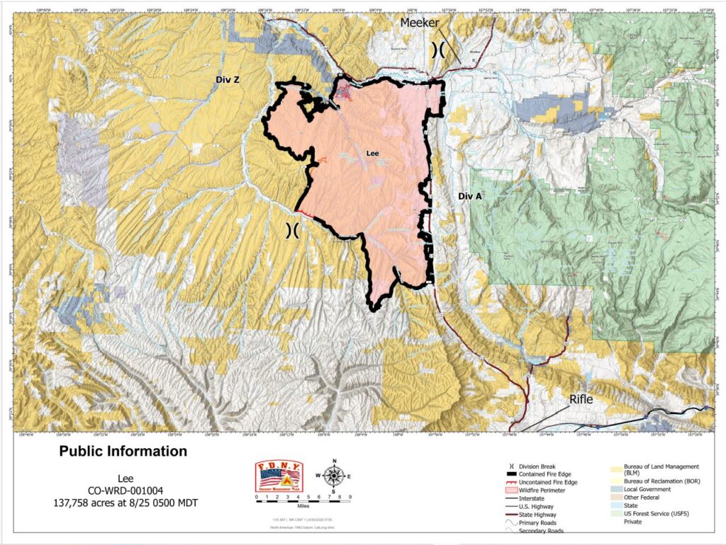
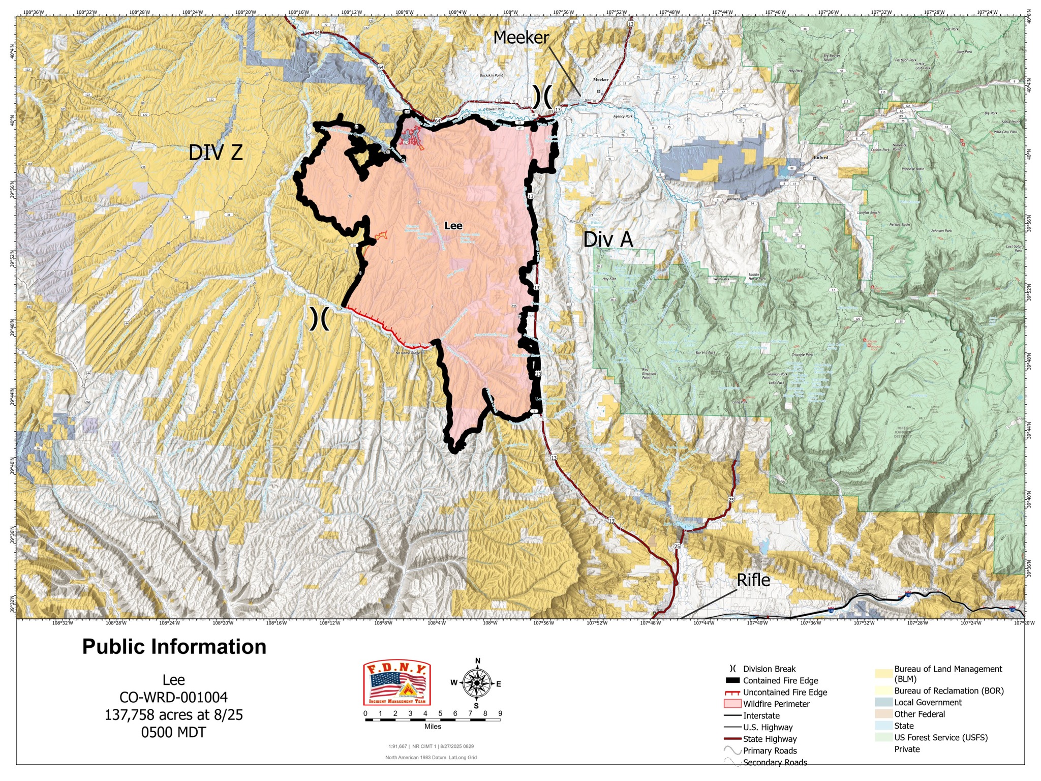
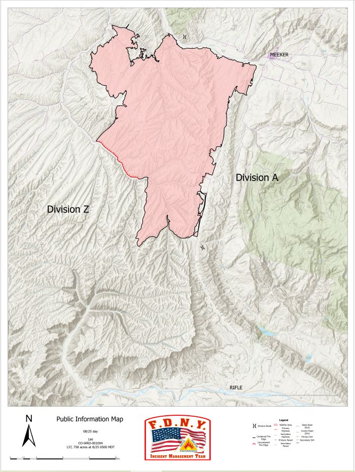
Location: 11 miles south of Meeker, Colorado Start Date: 08/02/2025 Cause: Lightning Size: Lee Fire: 137,758 acres Containment: Lee Fire: 95% 179 Total Personnel; 2 Hand Crews; 2 Dozers
KEY MESSAGE This is the final daily update from the FDNY Incident Management Team. On Monday morning at 0600, command of the fire will transition back to local agencies.
Over the past week, our team has been honored to serve alongside local, state, and federal partners in support of the Lee Fire. We are grateful for the cooperation, resilience, and support shown by the community and those working on the ground. As we prepare to return home, we do so with confidence in both the progress made and the agencies continuing this important work.
CURRENT STATUS Crews have now expanded suppression repair into additional areas of the fire, focusing on debris removal and restoration work. These projects are being completed in close coordination with Resource Advisors to ensure agency standards are met and to lay the groundwork for long-term recovery of the landscape.
WEATHER AND FIRE BEHAVIOR Clear skies and warming temperatures are expected today, accompanied by lower humidity. While the overall forecast points to mild and favorable conditions, there remains a chance for an isolated shower or thunderstorm this afternoon. Any storm activity could bring gusty winds up to 25 mph, which may briefly impact ongoing suppression repair. Looking ahead, the return to drier weather will allow crews to continue making steady progress across the fire area.
OPERATIONAL BRIEFING – AUGUST 30, 2025
August 30, 2025, Operational Briefing with Operations Section Vic Fernandez
CLOSURES AND SPECIAL MESSAGES For accurate up-to-date information on evacuations and road closures for Rio Blanco County, go to the Rio Blanco County Sheriff’s Office Facebook page at: https://www.facebook.com/RioBlancoCountySheriffsOffice.
Location: 11 miles south of Meeker, Colorado Start Date: 08/02/2025 Cause: Lightning Size: Lee Fire: 137,758 acres Containment: Lee Fire: 95% 195 Total Personnel; 8 Engines; 2 Hand Crews; 2 Water Tenders; 2 Dozers
KEY MESSAGE
Containment of the Lee Fire has increased to 95 percent. The addition of black line on the map reflects steady progress by firefighters patrolling the perimeter and completing suppression repair. Crews continue to strengthen lines and ensure the fire remains within its current footprint as work moves toward full containment.
CURRENT STATUS
Suppression repair is progressing across multiple areas, with crews conducting debris removal and other restoration work in coordination with Resource Advisors. These efforts are being carried out to agency standards and are designed to support long-term recovery.
WEATHER AND FIRE BEHAVIOR
Scattered rain showers are expected to continue into Saturday morning. While an isolated light shower or thunderstorm is possible in the afternoon, conditions will trend warmer and drier through the weekend. Temperatures are forecast to return to the 80s. Winds will generally be from the east at 5 mph, with gusts up to 17 mph possible near thunderstorms.
Location: 11 miles south of Meeker, Colorado Start Date: 08/02/2025 Cause: Lightning Size: Lee Fire: 137,758 acres Containment: Lee Fire: 90% 218 Total Personnel; 9 Engines; 2 Hand Crews; 2 Water Tenders; 2 Dozers
KEY MESSAGE The Lee Fire remains 137,758 acres with 90 percent containment. Fire activity has been minimal, with no growth observed. An infrared (IR) flight detected only a few hot spots, all of which were well inside the fire’s edge. Recent rainfall has kept conditions favorable, though crews remain mindful of flash flooding and debris flows that may follow periods of heavy rain.
CURRENT STATUS Today, firefighters will continue patrols along the fire’s edge to ensure it remains within its footprint. Suppression repair is underway in several areas, including debris removal, with crews working closely with Resource Advisors to complete this work to agency standards and support long-term recovery. Progress remains steady as work continues toward full containment and recovery of the fire area.
WEATHER AND FIRE BEHAVIOR Widespread rain showers are expected on Friday morning and will continue through much of the day. Some heavier showers may produce lightning and thunder. Conditions are forecast to dry out by late afternoon, with clearing skies into the evening. The rainfall will help keep fire activity minimal, though crews will remain alert for lightning strikes and the potential for flash flooding or debris flows in and around the burn area.
CLOSURES AND SPECIAL MESSAGES For accurate up-to-date information on evacuations and road closures for Rio Blanco County go to the Rio Blanco County Sheriff’s Office Facebook page at: https://www.facebook.com/RioBlancoCountySheriffsOffice.
Location: 11 miles south of Meeker, Colorado Start Date: 08/02/2025 Cause: Lightning Size: Lee Fire: 137,758 acres Containment: Lee Fire: 90% 215 Total Personnel; 9 Engines; 2 Hand Crews; 2 Water Tenders; 2 Dozers
CURRENT STATUS
Crews will continue patrols along the fire perimeter today to ensure it stays within its current footprint. Suppression repair operations are moving forward in close coordination with Resource Advisors and local agencies, following the approved Suppression Repair Plan.
Repair work is addressing areas disturbed by suppression activities, with crews working to stabilize firelines, restore ground conditions, and remove equipment no longer needed on the line. These efforts are an important step in reducing impacts and supporting long-term recovery efforts across the fire area.
Progress continues steadily as firefighters remain focused on these repair and patrol operations while working toward complete containment.
WEATHER AND FIRE BEHAVIOR
Storm chances remain in the forecast, with the highest potential for development on the southern portion of the fire. Storms are expected to track from the southwest to the northeast, with the best opportunity for development between 10:30 and 11:30 a.m. If skies clear during the late morning, storms are likely to form and bring rain, lightning, and the potential for localized flooding; if clouds remain in place, conditions may stay limited to lighter, scattered showers.
Location: 11 miles south of Meeker, Colorado Start Date: 08/02/2025 Cause: Lightning Size: Lee Fire: 137,758 acres Containment: Lee Fire: 90% 211 Total Personnel; 10 Engines; 2 Hand Crews; 2 Water Tenders; 2 Dozers
KEY MESSAGE
The reported acreage on the Lee Fire has been adjusted back to the original size noted earlier in the week, following improved mapping. The earlier increase was due to limitations in the previous data, which temporarily raised the estimate. With updated mapping complete, the acreage now accurately reflects the true fire size.
CURRENT STATUS
Yesterday, crews patrolled and secured the fire perimeter while completing suppression repair in coordination with Resource Advisors and local agencies, guided by the approved Suppression Repair Plan. The fire remained fully within its current footprint, and crews continued working both to strengthen containment and to begin repair in areas affected by suppression activities.
Fire activity was minimal, and work will continue in the coming days to ensure the area remains secureand repair objectives are met.
WEATHER AND FIRE BEHAVIOR
Showers and thunderstorms remain likely across the fire area over the next several days, with rainfall chances near 100%. Overnight and into the morning, widespread cloud cover with embedded showers is expected. If skies clear by midday, stronger thunderstorms could develop, increasing the risk of heavy rain and flash flooding. If cloud cover lingers, conditions will likely remain limited to lighter, intermittent rain with little lightning or strong winds.