Northern Rockies Complex Incident Management Team 3
Derby Fire update document
Derby Fire update document – Spanish
Derby Fire smoke outlook
Derby Fire map
Fire Information 970-355-3283
2025.Derby@firenet.gov
www.facebook.com/derbyfire
Northern Rockies Complex Incident Management Team 3
Incident Commander Mike Behrens
Location: 13 miles north of Dotsero, CO
Start date: 8/16/2025
Cause: Lightning
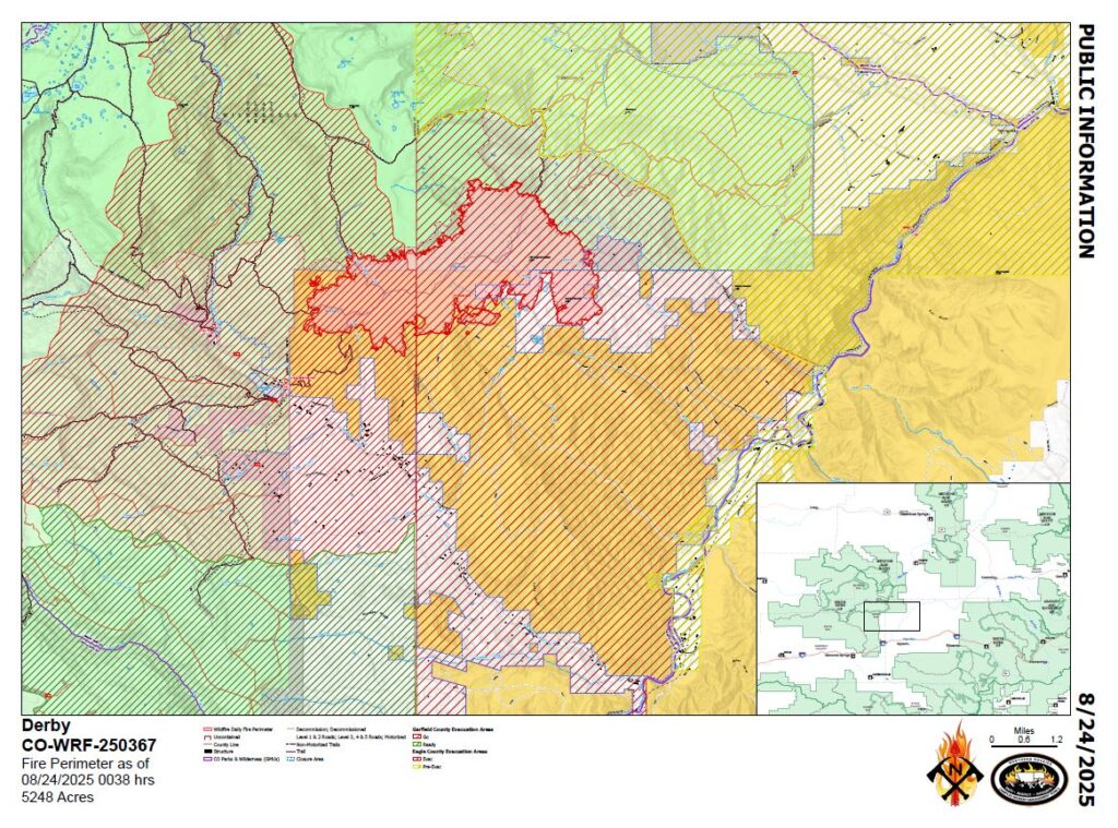
Size: Est. 5248 acres
Completion/Containment: 0%
525 total personnel
Key Message:
Firefighters are working to build and strengthen control lines along the Derby Fire’s west, south, and east perimeters. Aircraft supported ground operations by dropping water and flame retardant on the east and west flanks. The Colorado River Rd. closure has been extended south, closing access to Coffeepot Road.
Current Status:
The east side of the Derby Fire was more active on Saturday, and three aircraft dropped water and flame retardant to slow its spread down the slopes of its southeast flank. The fire is growing slowly on other parts of its south perimeter, where firefighters are constructing control lines from a network of roads, dozer line, and hand line. On Saturday they worked to strengthen and widen those fire lines and plan to continue on Sunday if weather and conditions permit. Other crews have protected over 500 structures by positioning sprinkler kits and removing surrounding fuels. The White River National Forest has expanded their closure order to include the area southwest of Sweetwater Lake to the west rim of Deep Creek Canyon. The Colorado River Rd. closure has been extended south, from the Dotsero roundabout’s north side to Red Dirt Rd. Note that Coffeepot Rd. cannot be accessed from its intersection with Colorado River Rd.
Weather and Fire Behavior:
Outflow winds have begun to push the Derby Fire south, but there is a good chance of wetting rain on Sunday. Rainfall may also be accompanied by some lightning. Daytime smoke and nighttime fire glows may be visible.
Closures and Special Messages:
Eagle County has issued an evacuation notice for residents of Sweetwater Rd. and Red Dirt Creek. Zones GYF-263, 266-A, 267, 300, 366, and 369 are in pre-evacuation status. More evacuation information is available at www.ecemergency.org, including where to shelter and resources for pets and livestock.
The Forest Service and BLM have both issued public closure orders in the vicinity of the fire to protect public and firefighter safety. The White River National Forest’s newly expanded closure order and map are posted at https://www.fs.usda.gov/r02/whiteriver/alerts/expanded-derby-fire-closure. The BLM Colorado River Valley Field Office’s closure order and map are posted at https://www.blm.gov/announcement/blm-issues-land-closure-garfield-and-eagle-counties-firefighting-activities. In addition, a Temporary Flight Restriction (TFR) is in place over the Derby Fire. All unauthorized aircraft (including drones) are prohibited from flying near the fire, as they can interfere with authorized air support operations. For more information, visit www.tfr.faa.gov.
Please find attached a pdf of the Smoke Outlook for the Derby Fire in NW Colorado. Detailed forecasts for specific locations are available here: https://outlooks.wildlandfiresmoke.net/outlook/4d276598?
Incedio Derby
Bosque Nacional White River
Información sobre incendios: 970-355-3283 2025;
Derby@firenet.gov;
https://inciweb.wildfire.gov/incident-information/cowrf-derby-fire
24 de agosto 2025
Equipo 3 de Gestión de Incidentes del Complejo de las Montañas Rocosas del Norte
Comandante de Incidentes Mike Behrens
Ubicación: 13 millas al oeste de Dotsero, CO
Fecha de inicio: 08/16/2025;
Causa: Rayo
Tamaño: Est. 5248 acres
Finalización/Contención: 0% –
525 Personal total
Mensaje clave:
Los bomberos están trabajando para construir y fortalecer las líneas de control a lo largo de los perímetros oeste, sur y este del incendio de Derby. Los aviones apoyaron las operaciones terrestres lanzando agua y retardantes de llama en los flancos este y oeste. El cierre de Colorado River Rd. se ha extendido hacia el sur, cerrando el acceso a Coffeepot Rd.
Estado actual:
El lado este del incendio Derby estaba más activo el sábado, y tres aviones arrojaron agua y retardante para frenar su propagación por las laderas de su flanco sureste. El incendio está creciendo lentamente en otras partes de su perímetro sur, donde los bomberos están construyendo líneas de control a partir de una red de carreteras, línea de topadoras y línea de mano. El sábado trabajaron para fortalecer y ampliar esas líneas de fuego y planean continuar el domingo si el clima y las condiciones lo permiten. Otras cuadrillas han protegido más de 500 estructuras colocando kits de rociadores y retirando los combustibles circundantes. El Bosque Nacional White River ha ampliado su orden de cierre para incluir el área al suroeste del lago Sweetwater hasta el borde oeste de Deep Creek Canyon. El cierre de Colorado River Rd. se ha extendido hacia el sur, desde el lado norte de la rotonda de Dotsero hasta Red Dirt Rd. Tenga en cuenta que no se puede acceder a Coffeepot Rd. desde su intersección con Colorado River Rd.
Comportamiento del clima y el fuego
Los vientos de salida han comenzado a empujar el incendio Derby hacia el sur, pero hay una buena posibilidad de lluvia húmeda el domingo. Las lluvias también pueden ir acompañadas de algunos rayos. El humo diurno y los resplandores nocturnos del fuego pueden ser visibles.
Cierres y mensajes especiales
El condado de Eagle ha emitido un aviso de evacuación para los residentes de Sweetwater Rd. y Red Dirt Creek. Las zonas GYF-263, 266-A, 267, 300, 366 y 369 están en estado previo a la evacuación. Hay más información sobre evacuación disponible en www.ecemergency.org, incluido dónde refugiarse y recursos para mascotas y ganado.
El Servicio Forestal y BLM han emitido órdenes de cierre público en las cercanías del incendio para proteger la seguridad pública y de los bomberos. La orden de cierre y el mapa del Bosque Nacional White River están publicados en https://www.fs.usda.gov/r02/whiteriver. La orden de cierre y el mapa de la Oficina de Campo del Valle del Río Colorado de BLM se publican en https://www.blm.gov/announcement/blm-issues-land-closure-garfield-and-eagle-counties-firefighting-activities. Además, existe una restricción temporal de vuelo (TFR por sus siglas en inglés) sobre el incendio de Derby. Todas las aeronaves no autorizadas (incluidos los drones) tienen prohibido volar cerca del incendio, ya que pueden interferir con las operaciones de apoyo aéreo autorizadas. Para obtener más información, visite www.tfr.faa.gov.
Derby Fire Information
Public Phone Line: (970) 355-3282
Office Hours: 8 a.m. to 8 p.m.
https://inciweb.wildfire.gov/incident-closures/cowrf-derby-fire
https://www.facebook.com/WhiteRiverNF