Northern Rockies Complex Incident Management Team 3
August 26, 2025 Derby Fire Update
#DerbyFire#FireYear2025
Derby Fire update document
Derby Fire update document – Spanish
Derby Fire smoke outlook
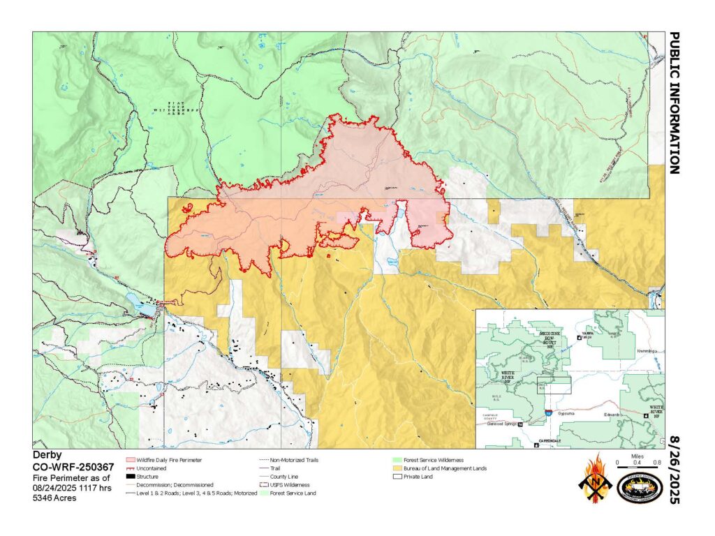
Derby Fire Map August 26, 2025
White River National Forest
Fire Information 970-355-3283; 2025.Derby@firenet.gov; www.facebook.com/derbyfire
https://inciweb.wildfire.gov/incident…/cowrf-derby-fire
Northern Rockies Complex Incident Management Team 3, Incident Commander Mike Behrens
Location: 13 miles north of Dotsero, CO
Start Date: 8/16/2025;
Cause: Lightning
Size: Est. 5,346 acres
Completion/Containment: 0% 844 total personnel
Key Message:
Coffeepot Road can again be accessed from its intersection with Colorado River Rd, as the southern end of the Colorado River Road closure has been moved northward. The Garfield County and Eagle County Sheriff’s Offices have changed the evacuation status for Sweetwater Valley and Sheep Creek to pre-evacuation (SET) status.
Current Status:
Wetting rain fell across the Derby Fire on Monday morning, and fire behavior has temporarily moderated across the area. However incident managers predict wildfire activity will increase again when the weather warms and fuels dry out. Firefighters are continuing to build control lines along the east, south, and west flanks from a network of roads, dozer line, and hand line. They will work to strengthen and widen those fire lines as weather and conditions allow. About three quarters of the recent growth on the eastern perimeter has been halted with new control lines. Structure protection crews are working along Red Dirt Creek Road. Across the fire they have prepared over 500 structures by positioning sprinkler kits and removing surrounding fuels. Incident managers held a community meeting Monday evening to engage the public and answer questions.
Weather and Fire Behavior:
Wetting rains fell on the Derby Fire on Monday morning, and there is a strong likelihood that the rains will continue on Tuesday and throughout the week. Daytime smoke and nighttime fire glows may be visible at times when fuels dry out and fire activity increases.
Closures and Special Messages:
Garfield and Eagle Counties have changed the evacuation status for Sweetwater Valley and Sheep Creek to pre-evacuation (SET). Zones GYF-263, 266-A, 267, 300, 366, and 369 are also in pre-evacuation status. More evacuation information is available at https://arcg.is/S0u4G and www.ecemergency.org, including where to shelter and resources for pets and livestock.
Coffeepot Road can again be accessed from its intersection with Colorado River Road, as the southern end of the Colorado River Road closure has been moved northward to a site just past its intersection with Coffeepot. Beyond that, Colorado River Road remains closed to non-residents and unapproved traffic through its intersection with Red Dirt Creek Road.
The Forest Service and BLM have both issued public closure orders in the vicinity of the fire to protect public and firefighter safety. The White River National Forest’s closure order and map are posted at https://www.fs.usda.gov/…/expanded-derby-fire-closure. The BLM Colorado River Valley Field Office’s closure order and map are posted at https://www.blm.gov/…/blm-issues-land-closure-garfield…. A Temporary Flight Restriction (TFR) is in place over the Derby Fire.
Please see the attached photo for today’s smoke outlook.
Incendio Derby 2025
Bosque Nacional White River
Información de incendios 970-355-3283; 2025.Derby@firenet.gov; www.facebook.com/derbyfire
https://inciweb.wildfire.gov/incident-information/cowrf-derby-fire
26 de agosto de 2025
Equipo 3 de Gestión de Incidentes Complejos de las Montañas Rocosas del Norte,
Comandante de Incidente Mike Behrens
Ubicación: 13 millas al oeste de Dotsero, CO
Fecha de inicio: 08/16/2025;
Causa: Rayos
Tamaño: Est. 5346 acres
Finalización/Contención: 0% 844 Personal total
Mensaje clave:
Se puede acceder nuevamente a Coffeepot Road desde su intersección con Colorado River Road, ya que el extremo sur del cierre de Colorado River Road se ha trasladado hacia el norte. Las Oficinas del condado de Eagle y del Sheriff del Condado de Garfield han cambiado el estado de evacuación de Sweetwater Valley y Sheep Creek a estado “LISTOS”, la etapa 2 que significa del proceso de evacuaciones que significa “prepárese y esté alerta”.
Estado actual:
El lunes por la mañana cayó lluvia torrencial sobre el incendio Derby, y el comportamiento del fuego se ha moderado temporalmente en toda la zona. Sin embargo, los administradores de incidentes predicen que la actividad de incendios forestales aumentará de nuevo cuando el clima mejore y los combustibles se sequen. Los bomberos continúan construyendo líneas de control a lo largo de los flancos este, sur y oeste a partir de una red de carreteras, una línea de excavadoras y una línea de mano. Trabajarán para reforzar y ampliar estas líneas de control según lo permitan el clima y las condiciones. Aproximadamente tres cuartas partes del reciente crecimiento en el perímetro este se han detenido con nuevas líneas de control. Los equipos de protección de estructuras están trabajando a lo largo de Red Dirt Creek Road. Al otro lado del incendio, han preparado más de 500 estructuras mediante la instalación de equipos de rociadores y la retirada de los combustibles circundantes. Los gestores de incidentes organizaron una reunión comunitaria el lunes por la noche para interactuar con el público y responder preguntas.
Comportamiento del clima y el fuego
El lunes por la mañana cayeron lluvias torrenciales sobre el incendio Derby, y es muy probable que continúen el martes y durante toda la semana. Es posible que se observe humo diurno y destellos nocturnos del fuego cuando los combustibles se sequen y aumente la actividad del incendio.
Cierres y mensajes especiales
Los condados Eagle y Garfield han cambiado el estado de evacuación para los residentes de Sweetwater Valley y Sheep Creek a “SET”, la etapa 2 del proceso de evacuaciones que significa “prepárese y esté alerta”. Las zonas GYF-263, 266-A, 267, 300, 366 y 369 están en estado previo a la evacuación. Para más información, incluido dónde refugiarse y recursos para mascotas y ganado, visite https://arcg.is/S0u4G o https://sites.google.com/eaglec…/ecemergencyespanol/inicio.
El Colorado River Road permanece cerrado para todos aquellos que no sean residentes y el tráfico no autorizado en la rotonda al norte de Dotsero hasta Red Dirt Road. Tenga en cuenta que no se puede acceder a Coffeepot Road desde su intersección con Colorado River Road.
El Servicio Forestal y BLM han emitido órdenes de cierre público en las cercanías del incendio para proteger la seguridad pública y de los bomberos. La orden de cierre y el mapa del Bosque Nacional White River están publicados en https://www.fs.usda.gov/r02/whiteriver. La orden de cierre y el mapa de la Oficina de Campo del Valle del Río Colorado de BLM se publican en https://www.blm.gov/…/blm-issues-land-closure-garfield…. Existe una restricción temporal de vuelo (TFR por sus siglas en inglés) sobre el incendio de Derby.
The photos below illustrate the Derby Fire Daily update, available in English and Spanish, the public information fire map for the day, evacuation and closure map and today’s smoke outlook. These documents are also available on the Derby Fire Inciweb website here: https://inciweb.wildfire.gov/incident…/cowrf-derby-fire
Derby Fire official information
FACEBOOK – Derby fire @derbyfire
INCIWEB – Derby Fire
WHITE RIVER NATIONAL FOREST – facebook.com/whiteriverNF @whiteriverNF
_______________
EAGLE COUNTY INFO
DERBY FIRE: EAGLE COUNTY EVACUATION MAP REGISTER FOR ALERTS – 911 alerts
INCIDENT UPDATES – EC Emergency or Reachwell app
FACEBOOK – facebook.com/eaglecountyso @eaglecountyso
________________
GARFIELD COUNTY INFO
DERBY FIRE: GARFIELD COUNTY INTERACTIVE EVACUATION MAP
REGISTER FOR ALERTS – 911 alerts or Reachwell app
INCIDENT UPDATES / SUBSCRIBE – Garfield County emergency
FACEBOOK – facebook.com/garcosheriff @garcosheriff