Lee Fire: Elk and Lee Fire Update – Tuesday, August 18, 2025

Rocky Mountain Complex Incident Management Team 3

Elk and Lee Fire Update document – English
Elk and Lee Fire Update document – Spanish

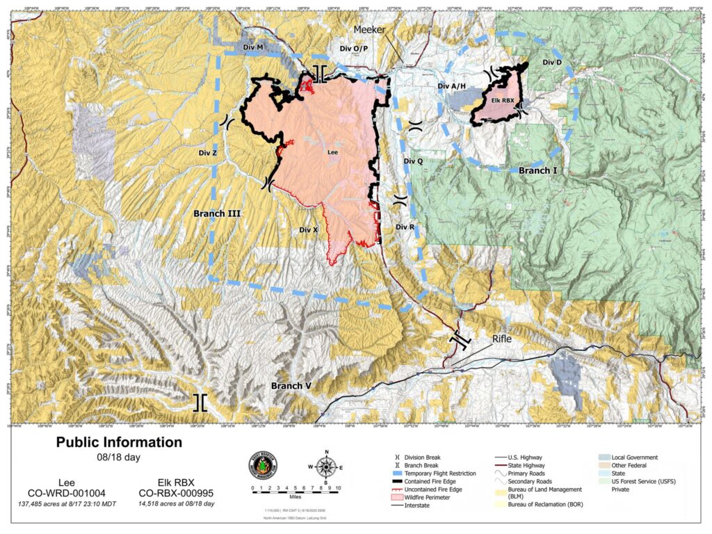
Size: Elk Fire: 14,518 acres | Lee Fire: 137,485 acres
Total Personnel: 1,000
Containment: Elk Fire: 100% | Lee Fire 61% Cause: Lightning
Resources: 5 Aircraft | 9 Hand Crews | 39 Engines | 22 Heavy Equipment
Miles of fireline constructed: Elk Fire: 47 miles | Lee Fire: 168 miles

Key message: Rocky Mountain Complex Incident Management Team 3 (RM CIMT 3) will transition today with the incoming Northern Rockies Complex Incident Management Team 1 (NR CIMT 1). The new team will shadow RM CIMT 3 throughout the day to ensure a seamless handoff. NR CIMT 1 will take over command of both incidents Monday at 5 p.m.

Important Notes: School starts today in the Meeker School District. Please be careful when driving as school traffic and fire traffic will be on the roads. The Rio Blanco County Sheriff’s Office downgraded several evacuation zones on Saturday. Check your evacuation zone on the interactive map: http://bit.ly/lee-fire-zones. Highway 13 is open with a speed limit of 50 mph. There is no stopping along the highway except in emergencies. Be aware that firefighters and utility personnel are working along the road.

Yesterday: Lee Fire – Firefighters focused on mopping up hotspots on the south and west sides of the fire, to strengthen and secure containment lines. County Road 5 remains a priority. Crews continued to patrol and monitor along Highway 13, as well as the north and northwest portions of the fire. Unmanned aerial systems (UAS) flights helped identify remaining heat along the perimeter of the fire. Crews also continued construction and clean-up of contingency lines south of the fire.

Elk Fire – Evaluation and implementation of suppression repair work continued. Crews are repairing dozer lines, hand lines, and other areas impacted by firefighting efforts to prevent future erosion and sedimentation.

Current Situation :

Lee Fire – Crews will monitor containment lines, hotspots, and any islands of unburned fuel. Light smoke may be visible today as temperatures rise, giving firefighters a chance to address remaining heat. Firefighters will mop up along the south and west sides of the fire and the County Road 5 corridor. Crews remain engaged protecting structures and other values at risk while reinforcing containment lines in those areas. Rocky Mountain Area Complex Incident Management Team 3 is coordinating closely with the Bureau of Land Management and other agencies to plan future repairs that meet established Lee Fire – Crews will monitor containment lines, hotspots, and any islands of unburned fuel. Light smoke may be visible today as temperatures rise, giving firefighters a chance to address remaining heat. Firefighters will mop up along the south and west sides of the fire and the County Road 5 corridor. Crews remain engaged protecting structures and other values at risk while reinforcing containment lines in those areas. Rocky Mountain Area Complex Incident Management Team 3 is coordinating closely with the Bureau of Land Management and other agencies to plan future repairs that meet established standards.

Elk Fire: Suppression repair efforts for the Elk Fire will continue. Crews are covering contingency lines with soil and spreading vegetation to help restore areas affected by firefighting operations to near pre-fire condition.

Weather & Fire Behavior: High pressure will strengthen today leading to hot, dry, and sunny conditions with highs near 86 degrees. Winds will be light and variable, generally out of the west, 5 to 10 mph in the afternoon. A drying trend is expected today through Wednesday. Some remaining hotspots dampened by rain over the last few days will likely show light smoke as fuels dry. Fuel moisture remains low, and significant precipitation would be needed to return levels to normal.

Evacuations and Closures: CR 5 remains closed. For accurate up-to-date information on evacuations and road closures for Rio Blanco County go to Rio Blanco County Sheriff’s Office Facebook page at: https://www.facebook.com/RioBlancoCountySheriffsOffice. For Garfield County updates go to: https://www.garfieldcounty.net/. White River National Forest closure information is available at: https://www.fs.usda.gov/r02/whiteriver/alerts. BLM White River Field Office closures information at: https://ow.ly/78uF50WGjNW.

Elk and Lee Fire Information:
Phone: 970-341-8665;
Email: 2025.elkrbx@firenet.gov
Facebook: www.facebook.com/elkleefire
Inciweb Lee Fire: https://inciweb.wildfire.gov/incident-information/cowrd-lee-fire
Inciweb Elk Fire: https://inceb.wildfire.gov/incident-infrmation/cowrd-elk-rbx-fire

Tamaño: Incendio Elk: 14.518 acres | Incendio Lee: 137.485 acres
Personal total: 1.000
Contención: Incendio Elk: 100% | Incendio Lee 61%
Causa: Relámpago
Recursos: 6 aviones | 9 cuadrillas | 39 camiones de bomberos | 22 maquinaria pesada
Millas de línea de fuego construida: Incendio Elk: 47 millas | Incendio Lee: 168 millas

Mensaje clave: El Equipo de Gestión de Incidentes del Complejo de las Montañas Rocosas 3 (RM CIMT 3 por sus siglas en inglés) hará la transición hoy con el Equipo de Gestión de Incidentes del Complejo de las Montañas Rocosas del Norte 1 (NR CIMT 1 por sus siglas en inglés). El nuevo equipo seguirá a RM CIMT 3 durante todo el día para garantizar una transferencia sin problemas. NR CIMT 1 asumirá el mando de ambos incidentes el lunes a las 5 p.m.

Notas importantes: La escuela comienza hoy en el Distrito Escolar de Meeker. Tenga cuidado al conducir, ya que el trafico escolar y el tráfico de bomberos estarán en las carreteras. La Oficina del Sheriff del Condado de Río Blanco degradó varias zonas de evacuación el sábado. Verifique su zona de evacuación en el mapa interactivo: http://bit.ly/lee-fire-zones. La autopista 13 está abierta con una reducción del límite de velocidad de 50 mph. No hay paradas a lo largo de la carretera, excepto en caso de emergencia. Tenga en cuenta que los bomberos y el personal de servicios públicos están trabajando a lo largo de la carretera.

Ayer: Incendio Lee – Los bomberos se centraron en limpiar los puntos calientes en los lados sur y oeste del incendio, para fortalecer y asegurar las líneas de contención. County Road 5 sigue siendo una prioridad. Las cuadrillas continuaron patrullando y monitoreando a lo largo de la autopista 13, así como las partes norte y noroeste del incendio. Los vuelos de sistemas aéreos no tripulados (UAS o drone) ayudaron a identificar el calor restante a lo largo del perímetro del incendio. Las cuadrillas también continuaron la construcción y limpieza de las líneas de contingencia al sur del incendio.

Incendio Elk – Continuó la evaluación e implementación del trabajo de reparación de supresión. Las cuadrillas están reparando las líneas de topadoras, las líneas manuales y otras áreas afectadas por los esfuerzos de extinción de incendios para evitar la erosión y sedimentación futuras.

Situación actual: Incendio Lee – Las cuadrillas monitorearán las líneas de contención, los puntos críticos y cualquier isla de combustible no quemado. El humo ligero puede ser visible hoy a medida que aumentan las temperaturas, lo que les da a los bomberos la oportunidad de abordar el calor restante. Los bomberos limpiarán los lados sur y oeste del incendio y el corredor County Road 5. Las cuadrillas permanecen comprometidas protegiendo estructuras y otros valores en riesgo mientras refuerzan las líneas de contención en esas áreas. El Equipo 3 de Manejo de Incidentes del Complejo del Área de las Montañas Rocosas está coordinando estrechamente con la Oficina de Administración de Tierras y otras agencias para planificar reparaciones futuras que cumplan con los estándares establecidos.

Incendio Elk – Continuarán los esfuerzos de reparación de supresión para el incendio Elk. Las cuadrillas están cubriendo las líneas de contingencia con tierra y esparciendo vegetación para ayudar a restaurar las áreas afectadas por las operaciones de extinción de incendios a una condición cercana a la anterior al incendio.

Comportamiento del clima y el fuego: La alta presión se fortalecerá hoy, lo que provocará condiciones cálidas, secas y soleadas con máximas cercanas a los 86 grados. Los vientos serán ligeros y variables, generalmente del oeste, de 5 a 10 mph por la tarde. Se espera una tendencia a la sequía desde hoy hasta el miércoles. Algunos puntos críticos restantes humedecidos por la lluvia en los últimos días probablemente mostrarán humo ligero a medida que se sequen los combustibles. La humedad del combustible sigue siendo baja y se necesitarían precipitaciones significativas para que los niveles vuelvan a la normalidad.

Evacuaciones y cierres: CR 5 permanece cerrado. Para obtener información precisa y actualizada sobre evacuaciones y cierres de carreteras para el condado de Río Blanco, visite la página de Facebook de la Oficina del Sheriff del Condado de Río Blanco en: https://www.facebook.com/RioBlancoCountySheriffsOffice. Para obtener actualizaciones del condado de Garfield , visite: https://www.garfieldcounty.net/. La información sobre el cierre del Bosque Nacional White River está disponible en: https://www.fs.usda.gov/r02/whiteriver/alerts. Información sobre cierres de la oficina de campo de BLM White River en: https://ow.ly/78uF50WGjNW.

Información sobre los incendios de Elk y Lee:
Teléfono: 970-341-8665; Correo electrónico: 2025.elkrbx@firenet.gov
Facebook: www.facebook.com/elkleefire
Iniciweb Incendio Lee: https://inciweb.wildfire.gov/incident-information/cowrd-lee-fire
Inciweb Incendio Elk: https://inciweb.wildfire.gov/incident-information/cowrd-elk-rbx-fire

Lee Fire: Elk and Lee Fire Update – Tuesday, August 18, 2025

Lee Fire: August 18 operational briefing video

A new video for August 18 has been posted on this page.

Rio Blanco County Sheriff’s Office
BLM Colorado Fire
Bureau of Land Management – Colorado
Colorado Division of Fire Prevention and Control
U.S. Forest Service – White River National Forest
Bureau of Land Management Fire
Garfield County Sheriff’s Office – Colorado
Garfield County Emergency Communications Authority
Colorado Parks and Wildlife
Rifle Police Department

Lee Fire: August 18 operational briefing video

Lee Fire: Incident Management Teams transition today

8.18.25, 6:54 a.m. – Good Morning, It was a quiet night on the fire. As the Incident Management Teams transition today, some crews will begin the demobilization process, but many firefighters and crews remain actively engaged on the scene. Their work continues as they patrol the area, monitor hot spots, reinforce containment lines, and carry out suppression repair efforts. The response is ongoing, and dedicated personnel are still hard at work.

Lee Fire: Incident Management Teams transition today

Elk and Lee Fire Update

Rocky Mountain Area Complex Incident Management Team 3

Elk and Lee Fire update document – English
Elk and Lee Fire update document – Spanish

Elk and Lee Fire Update – Thursday, August 14, 2025 – 10:32 am

Size: Elk Fire: 14,518 acres | Lee Fire: 127,107 acres
Total Personnel: 1,274
Containment: Elk Fire: 75% | Lee Fire 3%
Cause: Lightning
Resources: 10 Aircraft | 20 Hand Crews | 81 Engines | 35 Heavy Equipment

Important Notes: Yesterday, the Garfield County Sheriff’s Office upgraded the evacuation status of the following zones: 81 is in GO (red), 85 is in SET (yellow) 84 is in READY (green) Check your zone on this map: https://bit.ly/lee-fire-zones. The change in reported acreage on the Elk Fire is due to better mapping. The decrease in containment for the Lee Fire is due to an increase in acreage and expansion of the perimeter of the fire. Existing containment lines have not been lost. Critical fire weather is expected today on the Lee Fire. Critical fire weather is expected again today on the Lee Fire, then beginning to improve by Friday.

Yesterday: Lee Fire – Critical fire weather arrived as predicted, but firefighters along the Highway 13 corridor made good progress with operations going as planned. Cloud cover in the area aided suppression efforts. Crews working inside the fire reported decreased interior heat and smoke. On the south end, the spot fire just over Highway 5 held well and did not cross into Garfield County. From County Road 5 to County Road 3, lines remain secure. Additional crews are focusing along Highway 13 south to County Road 5 with the goal of making it safe for travel as soon as possible. Four hotshot crews, engines, and a UAS monitored for hotspots, work that will continue over the next several days.

Elk Fire: The Elk Fire remained within established control lines with minimal to no growth. Crews continued to patrol and mop-up, addressing creeping and smoldering hotspots. Work focused on reinforcing lines around structures and values at risk along County Roads 8, 40, and 49. Favorable winds supported suppression efforts, keeping the perimeter secure throughout the operational period.

Current Situation: Lee Fire – Active fire behavior is expected again today, especially in the southern area. Critical fire weather will bring shifting winds, low humidity, and hotter temperatures that will challenge existing lines along Highway 13. Crews will maintain point protection for communities, infrastructure, and other values at risk. Direct line construction will continue on the east side of the fire and from Highway 13 south to County Road 5, as well as holding and improving lines between County Roads 5 and 3. Hotspot detection will continue with UAS flights, supported by hotshot crews and engines for rapid response. The hotspot near the Garfield County line will remain a priority for full suppression and reinforcement.

Elk Fire: Crews will continue to patrol and mop-up the fire, reinforcing containment lines off County Road 8 and in the Beaver Creek area. Work will focus on keeping the fire within existing lines while protecting nearby structures values at risk.

Weather & Fire Behavior: Critical fire weather is expected today, with winds shifting to the west/southwest and gusts over 20 mph. Temperatures will be in the upper 80s to mid 90s, with relative humidity between 8–12 percent. Dry thunderstorms may develop in the afternoon, bringing erratic winds and the potential for rapid changes in fire behavior.

Evacuations and Closures: CR 5 and Hwy 13 remain closed. To sign up for Garfield County Emergency Alerts, go to: https://garco911.com/. For Garfield County updates go to: https://www.garfieldcounty.net/. Go to the Rio Branco County Sheriff’s Office Facebook page – https://www.facebook.com/RioBlancoCountySheriffsOffice – for accurate up-to-date information on all evacuations and road closures. To sign up for emergency alerts at: https://rioblancoalerts.genasys.com/portal/en. White River National Forest closure information at: https://www.fs.usda.gov/r02/whiteriver/alerts. BLM White River Field Office closures information at: https://www.blm.gov/…/blm-colorado-issues-emergency….

Actualización del incendio Elk y Lee – Jueves 14 de agosto de 2025: https://inciweb.wildfire.gov/…/actualizacin-del…

Rio Blanco County Sheriff’s Office
BLM Colorado Fire
Bureau of Land Management – Colorado

Colorado Division of Fire Prevention and Control
U.S. Forest Service – White River National Forest
Bureau of Land Management Fire
Garfield County Sheriff’s Office – Colorado
Colorado Parks and Wildlife

Elk and Lee Fire Update

CDPHE: Air Quality Health Advisory for Wildfire Smoke

Colorado Division Public Health and Environment Air Quality Division

Air Quality Health Advisory for Wildfire Smoke

Avisos en Español para todo el Estado (Colorado)

Issued for Rio Blanco, Garfield, Routt, Jackson, Grand, Eagle and Summit Counties
Issued at 8:15 AM MDT, Thursday, August 14, 2025

Issued by the Colorado Department of Public Health and Environment

Affected Area: Rio Blanco, Garfield, Routt, Jackson, Grand, Eagle and Summit Counties. Locations include, but are not limited to Meeker, Glenwood Springs, Steamboat Springs, Walden, Granby, Hot Sulphur Springs, Kremmling, Eagle, Vail and Breckenridge.

Advisory in Effect: 9:00 AM MDT, Thursday, August 14, 2025 to 9:00 AM MDT, Friday, August 15, 2025

Public Health Recommendations: If smoke is thick or becomes thick in your neighborhood you may want to remain indoors. This is especially true for those with heart disease, respiratory illnesses, the very young, and older adults. Consider limiting outdoor activity when moderate to heavy smoke is present. Consider relocating temporarily if smoke is present indoors and is making you ill. If visibility is less than 5 miles in smoke in your neighborhood, smoke has reached levels that are unhealthy.

Outlook: Widespread moderate to heavy smoke has been observed across much of the advisory area Thursday morning. Additional heavy smoke is possible Thursday afternoon and evening, and into Friday morning, for areas downwind of the wildfires in Rio Blanco County. Smoke impacts may shift northward on Thursday, impacting areas along and north of Interstate 70 within the advisory area.

For the latest Colorado statewide air quality conditions, forecasts, and advisories, visit: https://www.colorado.gov/airquality/colorado_summary.aspx

For the latest Smoke Blog, visit: https://colosmokeoutlook.blogspot.com/

For more information about smoke and your health, visit: https://cdphe.colorado.gov/outdoor-burning/wildfire-smoke-and-health

CDPHE: Air Quality Health Advisory for Wildfire Smoke

Elk and Lee Fire – Operational Briefing Video August 14, 2025

Rocky Mountain Area Complex Incident Management Team 3

Operational Briefing Video August 14, 2025 with Operations Section Chief, Jeramy Dietz

Rio Blanco County Sheriff’s Office
Garfield County Emergency Communications Authority
BLM Colorado Fire

Colorado Division of Fire Prevention and Control
Garfield County Sheriff’s Office – Colorado
Bureau of Land Management – Colorado
U.S. Forest Service – White River National Forest
Rifle Police Department

Check your zone on this INTERACTIVE EVACUATION MAP (search your address).

The Elk and Lee Fire Information Facebook page

Garfield County: REGISTER FOR ALERTS – garco911.com, INCIDENT UPDATES/SUBSCRIBE – garfieldcounty.net, FACEBOOK – facebook.com/garcosheriff

Elk and Lee Fire – Operational Briefing Video August 14, 2025

Lee Fire: morning update from the Elk & Lee fires

Rocky Mountain Complex Incident Management Team 3

Elk Fire: 14,518 acres | 75% contained
Lee Fire: 127,107 acres | 4% contained

There will be a public meeting tonight at 7pm at the Colorado Mountain College, Rifle Campus. A Spanish interpreter will be present.

A Red Flag Warning is in effect today, with high temperatures, low humidity, and shifting winds expected to increase fire activity and spotting potential.

Crews on both fires are using a mix of direct and indirect strategies to secure edges, protect homes and other values at risk, and address spot fires. Aircraft are supporting ground efforts and adjusting operations to improve safety as conditions change.

The change in acreage is due to better mapping overnight.

Photo Credit: Wyoming Interagency Hotshots

Rio Blanco County Sheriff’s Office
BLM Colorado Fire
Bureau of Land Management – Colorado
Colorado Division of Fire Prevention and Control
U.S. Forest Service – White River National Forest
Bureau of Land Management Fire
Garfield County Sheriff’s Office – Colorado
Garfield County Emergency Communications Authority
Colorado Parks and Wildlife

Lee Fire: morning update from the Elk & Lee fires

Elk and Lee fires afternoon update

Rocky Mountain Complex Incident Management Team 3

August 13, 2025, 4:42 p.m. – Critical fire weather arrived as forecasted, bringing hot, dry conditions and increasing west-northwest winds that have driven more active fire behavior and are challenging containment lines. Operations today, including strategic firing, have gone as planned, with ground crews receiving support from aerial resources, including the Chinook helicopter shown here.

Inciweb Lee Fire: https://inciweb.wildfire.gov/incident…/cowrd-lee-fire
Inciweb Elk Fire: https://inciweb.wildfire.gov/incident…/cowrd-elk-rbx-fire

Check your zone on this INTERACTIVE EVACUATION MAP (search your address).

The Elk and Lee Fire Information Facebook page

Rio Blanco County Sheriff’s Office
BLM Colorado Fire
Bureau of Land Management – Colorado

Colorado Division of Fire Prevention and Control
U.S. Forest Service – White River National Forest
Bureau of Land Management Fire
Colorado Parks and Wildlife

Garfield County: REGISTER FOR ALERTS – garco911.com, INCIDENT UPDATES/SUBSCRIBE – garfieldcounty.net, FACEBOOK – facebook.com/garcosheriff

Elk and Lee fires afternoon update

EVACUATION update from Garfield County Sheriff’s Office:

Garfield County Sheriff’s Office

Zone 81 is in GO (red)

Zone 85 is in SET (yellow)

Zone 84 is in READY (green)

Check your zone on this map: https://bit.ly/lee-fire-zones

The southern edge of the Lee Fire has reached the Garfield County line, prompting the above changes to evacuation status.

Zone 81 and 85 are on top of the Roan Plateau in industrial landscape and BLM area (already under a closure), not residential areas.

Fire managers’ strategic planning includes multiple secondary and contingency lines between the fire’s edge and the southern edge of the Roan Plateau.

As a reminder:

GO = Evacuate immediately from your area. Leave now – danger in your area.

SET = Short notice evacuation likely in your area. Prepare for sudden evacuations. Leave now if you need extra time.

READY = Possible evacuation in your area. Prepare, monitor, and pack your valuables.

READY - possible evacuation in your area, SET - short notice evacuation likely in your area, GO - evacuation immediately from your area graphic.

INTERACTIVE EVACUATION MAP: http://bit.ly/lee-fire-zones

Garfield County: REGISTER FOR ALERTS – garco911.com

INCIDENT UPDATES/SUBSCRIBE – garfieldcounty.net

FACEBOOK – facebook.com/garcosheriff

Elk and Lee Fire Information page: https://www.facebook.com/elkleefire


Oficina del Sheriff del Condado de Garfield

La zona 81 está en GO (rojo)

La zona 85 está en SET (amarillo)

La zona 84 está en LISTO (verde)

Consulta tu zona en este mapa: https://bit.ly/lee-fire-zones

El borde sur del incendio Lee ha llegado a la línea del condado de Garfield, lo que provocó los cambios mencionados anteriormente en el estado de evacuación.

Las zonas 81 y 85 están en la parte superior de la meseta de Roan en el paisaje industrial y el área BLM (ya bajo cierre), no son áreas residenciales.

La planificación estratégica de los administradores de incendios incluye múltiples líneas secundarias y de contingencia entre el borde del incendio y el borde sur de la meseta de Roan.

Como recordatorio:

SALIR = Evacuar inmediatamente su zona. Salga ahora: peligro en su zona.

SET = Posible evacuación con poca antelación en su zona. Prepárese para evacuaciones repentinas. Salga ahora si necesita más tiempo.

PREPARADO = Posible evacuación en su zona. Prepare, vigile y empaque sus objetos de valor.

MAPA DE EVACUACIÓN INTERACTIVO: http://bit.ly/lee-fire-zones

Condado de Garfield: REGÍSTRESE PARA RECIBIR ALERTAS – garco911.com

ACTUALIZACIONES DE INCIDENTES/SUSCRÍBASE – garfieldcounty.net

FACEBOOK – facebook.com/garcosheriff

Página de información sobre incendios de Elk y Lee: https://www.facebook.com/elkleefire

EVACUATION update from Garfield County Sheriff’s Office: