Rocky Mountain Area Complex Incident Management Team 3
Sometimes the ground is just too steep or rugged for crews to get in safely or quickly. That’s when helicopters become essential.
From shuttling firefighters into remote areas, to hauling tools and gear, to dropping water on hot spots, and even extracting crews when needed, helicopters give firefighters the access and support they need to get the job done.
In this video, the Wyoming Hotshots are flown into the Hack Lake area to reach the fire from above and work their way around the perimeter. Using aircraft in this way helps improve both safety and efficiency for firefighters on the ground.
Fire Information: 970-355-3283 Size: 5,475acres Total Personnel: 531 Containment: 23% Cause: Lightning Resources: 5 Aircraft | 7 Hand Crews | 26 Engines | 9 Heavy Equipment
Current Situation:
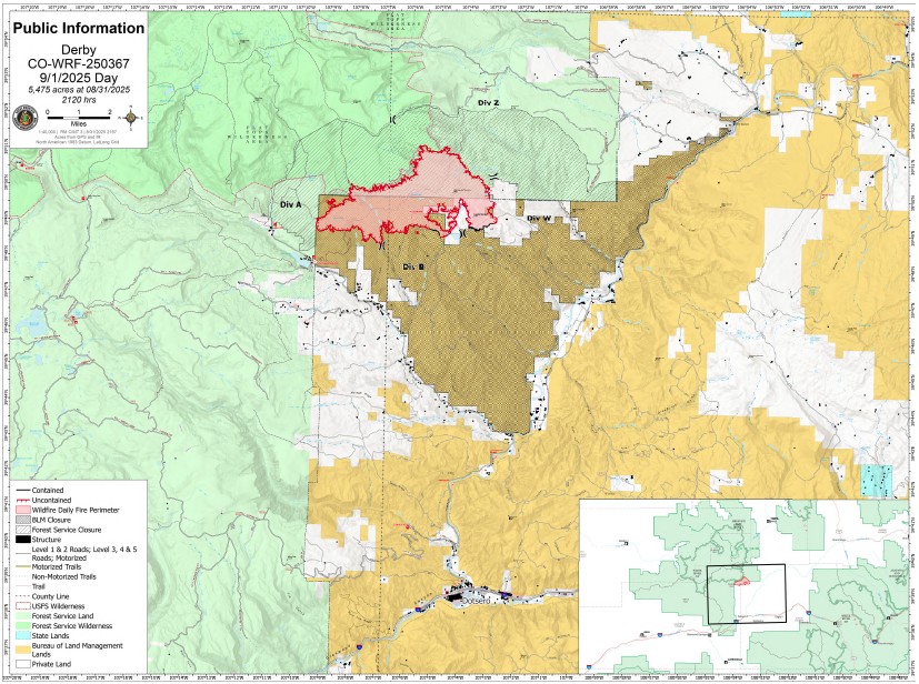
Containment increased to 23% on the Derby Fire, with new gains on the north and south flanks. The fire has burned into a steep rock face on its northern edge which creates a natural barrier to fire spread. Days of dedicated mop-up and cold trailing operations have secured handline and dozer line on the southern edge, contributing to the rise in containment.
Fire intensity increased Monday on the southwestern side of the fire in the area of the county line and West Fork Sheep Creek. Helicopter water drops assisted a fire suppression module on the ground working to extinguish these hot spots. On Tuesday, they will continue their work in the area. Air resources will have a busy day delivering firefighters, medical, and support personnel to all sides of the fire. A hotshot crew will be moved to the north flank of the fire to work direct on the fire’s edge in the West Fork Sheep Creek drainage in the Flat Tops Wilderness Area. Firefighters utilize specific tactics when fighting fire in wilderness areas to minimize near and long-term impacts to the natural environment while most effectively engaging the fire. Additional firefighting resources have arrived on the incident and will be flown to the northeastern corner where they will work south extinguishing hotspots on the fire’s edge. Hand crews spiked near the West Fork Red Dirt Creek will continue to advance handline construction toward crews working north from Poison Creek. Specialized medical personnel will be staged nearby to assist crews in the event of an emergency.
Weather & Fire Behavior:
Fire activity will continue to increase Tuesday as temperatures will be in the low 70’s. Humidity levels are expected to drop into the teens, with a very low chance of precipitation. Lower humidity levels mean that there’s less moisture in the air and light fuels like grasses, leaves and brush dry out. Light fuels are more sensitive to changes in moisture and are more conducive to burning. Fire behavior analysts don’t expect significant increase in fire behavior; however, firefighters will watch for an increase in creeping, smoldering and isolated tree torching.
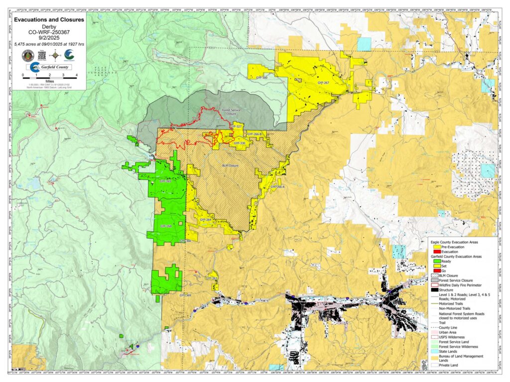
Evacuations and Closures: Fire restrictions and closures remain in place for Bureau of Land Management – Colorado River Valley Field Office areas, https://www.blm.gov/ucr-fire-restrictions. Restrictions and closures remain in the White River National Forest. See Critical and Fire Restriction Forest Alerts at https://www.fs.usda.gov/r02/whiteriver/alerts/.
The Colorado River, Sweetwater, and Red Dirt Creek roads have all been reopened, and the Garfield County and Eagle County Sheriff’s Offices have changed the evacuation status for Sweetwater Valley, Sheep Creek and Red Dirt Creek areas to pre-evacuation (READY) status: https://arcg.is/S0u4G and www.ecemergency.org.
A Temporary Flight Restriction (TFR) is in place over the Derby Fire. For more information, visit https://tfr.faa.gov.
Derby Fire Information
Phone: 970-355-3283 (8:00 a.m. to 8:00 p.m.) Email: 2025.Derby@firenet.gov
Actualización Diaria para el Incendio Derby – el 2 de septiembre de 2025
Equipo 3 del Manejo de Incidentes Complejos del Área de las Montañas Rocosas
Comandantes del Incidente: Casey Cheesbrough, Jay Miller, Ben Sanders
Información del incendio: 970-355-3283 Acres: 5,475 Personal: 531 Contención: 23% Causa: Rayos Recursos: 5 aeronaves | 7 cuadrillas | 26 camiones de bomberos | 9 equipo pesados
Situación Actual:
La contención del incendio Derby aumentó al 23%, con nueva seguridad en los flancos norte y sur. El incendio ha quemado una pared rocosa escarpada en su borde norte, lo que crea una barrera natural para su propagación. Días de operaciones dedicadas de extinción y rastreo en frío han asegurado la línea de fuego manual y la línea de excavadoras en el borde sur, lo que ha contribuido a aumentar la contención.
La intensidad del incendio aumentó el lunes en el lado suroeste, en la zona del límite del condado y West Fork Sheep Creek. El lanzamiento de agua desde helicópteros apoyó a un módulo de extinción de incendios en tierra que trabaja para extinguir estos focos secundarios. El martes, continuarán su trabajo en la zona. Los recursos aéreos tendrán una jornada intensa, transportando bomberos, médicos y personal de apoyo a todos los lados del incendio. Un equipo de bomberos se desplazará al flanco norte del incendio para trabajar directamente en el borde del incendio en el drenaje de West Fork Sheep Creek, en el Flat Tops Wilderness Area. Los bomberos utilizan tácticas específicas al combatir incendios en zonas silvestres para minimizar los impactos a corto y largo plazo en el entorno natural y, al mismo tiempo, combatir el fuego de la manera más eficaz. Recursos adicionales de extinción de incendios han llegado al lugar del incidente y se trasladarán por aire a la zona noreste, donde trabajarán hacia el sur extinguiendo los puntos calientes en el borde del incendio. Las cuadrillas ubicadas cerca de West Fork Red Dirt Creek continuarán avanzando con la construcción de la línea de extinción manual hacia las cuadrillas que trabajan al norte desde Poison Creek. Se desplegará personal médico especializado en las inmediaciones para asistir a las cuadrillas en caso de emergencia.
Clima y el comportamiento del fuego:
La actividad de incendios continuará aumentando el martes, con temperaturas cercanas a los 70°F. Se espera que el nivel de humedad baje entre 10 y 19%, con una probabilidad muy baja de precipitaciones. Una humedad más baja implica menos humedad en el aire y que los combustibles ligeros, como la hierba, las hojas y la maleza, se sequen. Estos combustibles ligeros son más sensibles a los cambios de humedad y más propensos a quemarse. Los analistas del comportamiento del fuego no prevén un aumento significativo; sin embargo, los bomberos estarán atentos a un aumento de incendios sigilosos, latentes y aislados de árboles.
Las restricciones y cierres por incendios se permanecen vigentes en los terrenos bajo la administración de la Oficina de Administración de Tierras del Valle del Río Colorado: https://www.blm.gov/ucr-fire-restrictions. Las restricciones y cierres por incendios se permanecen vigentes en Bosque Nacional White River. Consulte las alertas forestales críticas y de restricciones por incendios en https://www.fs.usda.gov/r02/whiteriver/alerts/.
Se han reabierto los caminos Colorado River Road, Sweetwater Road y Red Dirt Creek. Los condados Eagle y Garfield han cambiado el estado de evacuación para los residentes de Sweetwater Valley, Sheep Creek, y Red Dirt Creek a “LISTOS”, la etapa 1 del proceso de evacuaciones que significa que “esté preparados”: https://arcg.is/S0u4G o https://sites.google.com/eaglec…/ecemergencyespanol/inicio.
Se ha establecido una Restricción Temporal de Vuelo (TFR) sobre el incendio Derby. Para más información, visite https://tfr.faa.gov.
Información sobre el incendio de Derby
Teléfono: 970-355-3283 (de 8:00 a. m. a 8:00 p. m.) Correo electrónico:2025.Derby@firenet.gov
Rocky Mountain Area Complex Incident Management Team 3
#DerbyFire Operations Update, Tuesday, Sept. 2, 2025, Ryan Sharpe Operations Sections Chief, discusses firefighting tactics on the #DerbyFire.
Containment rose to 23% on the Derby Fire with new gains on the north and south flanks. Today will be a busy day for air operations and crews. 80 personnel will be flying to various assignments. Operations Sections Chief Ryan Sharpe explains the duties of the day.
Northern Rockies Complex Incident Management Team 3
Northern Rockies Complex Incident Management Team 3 thanks Garfield and Eagle Counties while welcoming in the new Rocky Mountain Incident Management Team 3.
Northern Rockies Complex Incident Management Team 3
Unaweep Wildfire Module 1 set up a time lapse camera on a prominent lookout west of Sugarloaf Mountain near where they were working on the southeast side of the fire. The view is looking north over the Horse Creek drainage capturing the #DerbyFire as it spread east from the morning of August 21 through the morning of August 24, 2025. Images were captured every 5 minutes. WFM1 Unaweep is based in Grand Junction, CO. #FireYear2025
Video: Clouds move past a dirt road as firefighters and engines periodically move past. Smoke rises from the right-hand side of the video, growing more intense as the Derby Fire spreads east. In the evening hours, the smoke glows yellow and red.
Northern Rockies Complex Incident Management Team 3, Incident Commander Mike Behrens
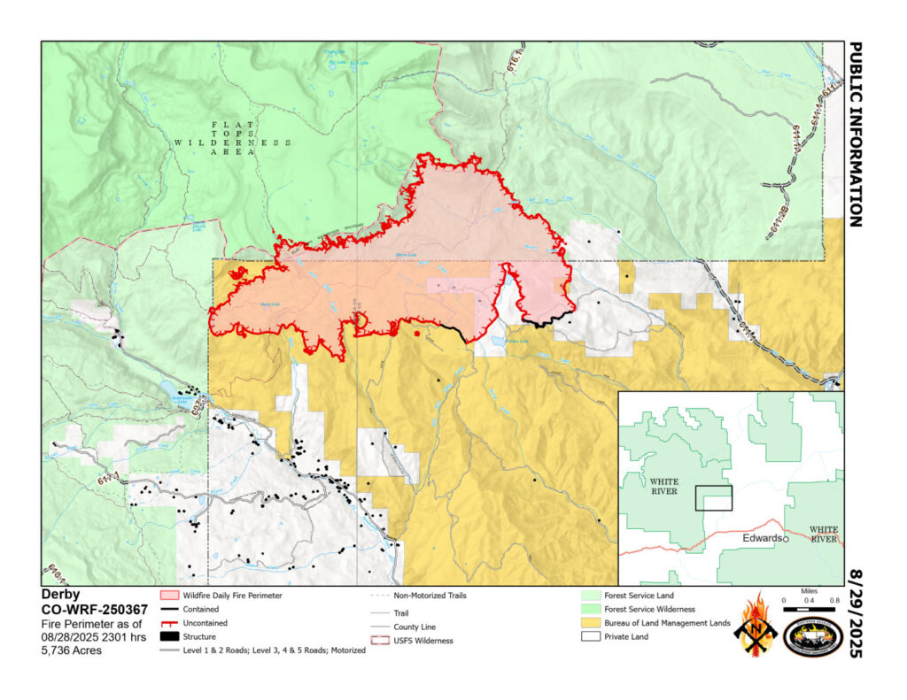
Location: 13 miles north of Dotsero, CO Start Date: 8/16/2025; Cause: Lightning Size: Est. 5,736 acres Completion/Containment: 5% Total personnel 692
Key Message:
Firefighters continue suppression efforts. Smoldering and lone tree torching persist at higher elevations. Transfer of Command from Northern Rockies Complex Incident Management Team 3 to Rocky Mountain Complex Incident Management Team 3 will occur at 6:00 a.m. on Saturday, August 30, 2025.
Current Status:
Firefighters continue scouting opportunities to construct indirect dozer line on the west side of the fire as well as possibilities to engage direct. On the southern and southeastern flanks, crews are patrolling, mopping up and cold trailing. Cold trailing involves gently feeling the ground and partially burned vegetation for residual heat and extinguishing any remaining hotspots. On the eastern perimeter, firefighters are progressing with indirect handline construction as weather conditions permit. Structure protection crews are working to improve and maintain fire defenses around more than 500 structures along Sweetwater Valley, Sheep Creek, and Red Dirt Creek Road.
WEATHER AND FIRE BEHAVIOR:
Remnants of Hurricane Juliette will bring showers and thunderstorms on Friday, with potential for localized flash flooding and light debris flows. Over the past five days, the fire area received 0.75 inches of rain – more than 100 million gallons of water. Fire activity will be minimal until conditions dry out and several days of low relative humidity make fuels more flammable. However, low moisture levels in dead and downed trees will continue to produce isolated pockets of smoldering in higher elevation conifer stands. Isolated tree torching in subalpine firs is possible. Smoke may increase when sunlight re-energizes these pockets of heat. Gradually warmer and drier weather is expected beginning Sunday.
The Colorado River, Sweetwater, and Red Dirt Creek Roads have all been reopened, and the Garfield County and Eagle County Sheriff’s Offices have changed the evacuation status for Sweetwater Valley, Sheep Creek and Red Dirt Creek areas to pre-evacuation (READY) status: https://arcg.is/S0u4G and www.ecemergency.org.
A Temporary Flight Restriction (TFR) is in place over the Derby Fire. All unauthorized aircraft (including drones) are prohibited from flying near the fire, as they can interfere with authorized air support operations. For more information, visit https://tfr.faa.gov.
All monitors showing GOOD air quality this morning and forecasted to remain GOOD all day. Very little smoke seen on the fire yesterday and the IR flight last night showed very little heat.
Equipo 3 de Gestión de Incidentes Complejos de las Montañas Rocosas del Norte, Comandante de Incidente Mike Behrens Ubicación: 13 millas al oeste de Dotsero, CO Fecha de inicio: 08/16/2025; Causa: Rayos Tamaño: Est. 5,736 acres Finalización/Contención: 5% Personal total: 692
Mensaje clave:
Los bomberos continúan las labores de extinción. Persisten las llamas latentes y la quema de árboles solitarios en las zonas más altas. El traspaso del mando del Equipo 3 de Gestión de Incidentes Complejos de las Montañas Rocosas del Norte al Equipo 3 de Gestión de Incidentes Complejos de las Montañas Rocosas tendrá lugar a las 6:00 a. m. del sábado, el 30 de agosto de 2025.
Estado actual:
Los bomberos continúan explorando oportunidades para construir una línea indirecta con excavadoras en el lado oeste del incendio, así como para intervenir directamente. En los flancos sur y sureste, las cuadrillas están patrullando, y continuando con la liquidación y rastreo en frío. Este sistema consiste en tocando con cuidado el suelo y la vegetación parcialmente quemada para detectar calor residual y extinguir cualquier foco de incendio restante. En el perímetro este, los bomberos avanzan con la construcción de una línea manual indirecta según lo permitan las condiciones climáticas. Las cuadrillas de protección de estructuras trabajan para mejorar y mantener las defensas contra incendios en torno a más de 500 estructuras a lo largo de Sweetwater Valley, Sheep Creek y Red Dirt Creek Road.
Comportamiento del clima y el fuego
Los remanentes del huracán Juliette traerán lluvias y tormentas eléctricas el viernes, con potencial de inundaciones repentinas localizadas y flujos de escombros leves. Durante los últimos cinco días, la zona del incendio recibió 0.75 pulgadas de lluvia, lo que equivale a más de 100 millones de galones de agua. La actividad del fuego será mínima hasta que las condiciones se sequen y varios días de baja humedad relativa aumenten la inflamabilidad de los combustibles. Sin embargo, los bajos niveles de humedad en los árboles muertos y caídos continuarán produciendo focos aislados de llamas latentes en las arboledas de coníferas de mayor altitud. Es posible que se quemen algunos árboles en abetos subalpinos. El humo podría aumentar cuando la luz solar revitalice estos focos de calor. Se espera un clima gradualmente más cálido y seco a partir del domingo.
Se han reabierto los caminos Colorado River Road, Sweetwater Road y Red Dirt Creek. Los condados Eagle y Garfield han cambiado el estado de evacuación para los residentes de Sweetwater Valley, Sheep Creek, y Red Dirt Creek a “LISTOS”, la etapa 1 del proceso de evacuaciones que significa que “esté preparados”: https://arcg.is/S0u4G o https://sites.google.com/eaglecounty.us/ecemergencyespanol/inicio.
Se prohíbe el vuelo de aeronaves no autorizadas (incluidos drones) cerca del incendio, ya que pueden interferir con las operaciones de apoyo aéreo autorizadas. Para más información, visite https://tfr.faa.gov.
Northern Rockies Complex Incident Management Team 3
#DerbyFire Ops Update Friday morning, Aug. 29, 2025. Phillip Knaub, Operations Sections Chief, discusses firefighting tactics on the Derby Fire. Northern Rockies Incident Management Team 3 transitions to Rocky Mountain Incident Management Team 3 Saturday August 30th at 6AM. As the drying trend continues through the weekend and into next week, smoke visibility will increase. Crews are working along the southern edge improving containment lines and continuing to extinguish any hot spots. Along the western edge, firefighters are working to create secondary handlines and dozer lines. Along the eastern side, crews are digging handlines to tie into existing lines and continue mopup operations.
Northern Rockies Complex Incident Management Team 3
Derby Fire Weather Update, Friday, August 29, 2025
Samuel Scoleri, Incident Meteorologist trainee, shares the weather forecast for the next few days on the Derby Fire north of Dotsero, CO. Remnants of Hurricane Juliette will bring wetting rain and possible thunderstorms today. Please be cautious as there’s potential for localized flash flooding and light debris flows over roadways. Beginning Sunday, the weather will be gradually warmer and drier.
Northern Rockies Complex Incident Management Team 3
Wildland firefighting can be dangerous work, and our crews are always preparing for the unexpected. In this video, a Forest Service fire suppression module practices training for what to do if a firefighter is hurt on the fireline or in a remote area. These drills make sure that if the unfortunate happens, crews are ready to take care of each other and get everyone home safe.