Northwest Colorado Interagency Fire
Contact: Patrick Kieran, Public Information Officer (720) 679-4234
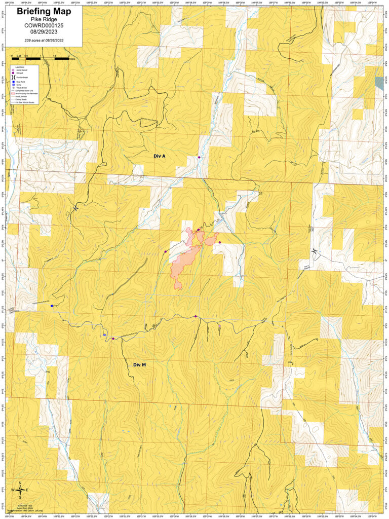
Location: Approximately 28 miles North of Loma, Colorado.
Jurisdiction: Bureau of Land Management, Grand Junction Field Office, and White River Field Office, Private.
Discovered: 08/12/2023 01:52 p.m.
Cause: Lightning
Vegetation type: Beetle Kill Spruce/Conifer, Mountain Brush
Estimated size: 242 acres.
Containment: 0%
Threatened structures: 1 historical homestead
Current status: Weather conditions are drying out and wind gusts of 25 mph are anticipated for Wednesday afternoon. The next round of Monsoon moisture is Friday through the weekend. Some smoke can be seen in the area. The Northern Utah Type 3 Interagency Management Team has completed Transfer of Command on Tuesday, 08/29. Fire suppression actions continue while maintaining safety for the public and firefighters. Current size is 242 acres, burning in a decadent Spruce/Conifer beetle kill Forest. There are now over 120 fire personal comprising of Aviation, Crews, Engines, and Overhead.
Planned actions: Structure protection of non-occupied historic homestead are complete. Suppression actions are ongoing. The Hand Crews and Engines are preparing County Roads as a holding feature. They are removing vegetation along roads to lessen fire intensity if these County Roads need to be ignited to perform a burnout operation. The assistance of a mechanical masticator has sped up the process. Fire and Land Managers are constantly assessing resources, communications, and working partnerships while ensuring public and firefighter safety.
Evacuations and closures: No evacuations.
Closures: To protect persons, property, public lands, and resources these roads are closed to all public use to support the Pike Ridge Fire. BLM lands within Garfield and Rio Blanco Counties. Public lands within ¼ mile south of Garfield County Road 256, East of Pike Ridge, and West of Garfield County Road 257.
Smoke: Smoke will be visible from the Grand Valley, Meeker and Rangely, Co areas. Travelers on Highway 139 from Loma, CO to Rangely, CO will see the most some. Smoke is not impacting any roadway directly. Go to airnow.gov to view local airsheds and national smoke report.
Aviation safety: Aircraft may be used over the Pike Ridge Fire air space. Fire aviation resources are flying at different altitudes and speeds. Pilots should exercise caution when flying near wildfires to keep everyone safe. Temporary Flight Restriction (TFR) FDC 3/9155 is in place through 09/22/2023. Unmanned aircraft systems (UAS) or drones must never fly near wildfires, as UAS are difficult to see and drone pilots have no way of communicating with firefighting aircraft. The only UAS or drones able to fly are agency owned and operated and have been assigned to work on the wildfire and have communication with air operations. Remember if you fly, we can’t!